Showing 500 items
matching mining - maps
-
 Bendigo Historical Society Inc.
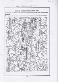
Document - DIAMOND HILL, GOLDEN GULLY COSERVATION AREA
... BENDIGO Mining golden gully Map of Golden Gully conservation area ...Map of Golden Gully conservation area comprising Glasgow and Golconda Consolidated, Glasgow Reef Company (Golden Gully) and New Napoleon. The area is significant because it contains the 'best evidence for hydraulic sluicing on the field as well as several early reef mining sites' On top of page 'Eaglehawk & Bendigo Heritage Study, Significant areas' Mines marked on page: Goldfields Extended shaft South Concord shaft Concord shaft Morning Light shaft Hansel and Mundy shaftbendigo, mining, golden gully -
 Bendigo Historical Society Inc.
Document - STAFFORD REEF MINE SITE, DIAMOND HILL
One page document describing the Stafford Reef Mine Site, Diamond Hill, Site 4.11, prepared by David Bannear. Information includes the map/grid references of the site and an overview of the history of the Stafford Reef Mine. The physical remains of the mine are described..bendigo, mining, stafford reef mine -
 Bendigo Historical Society Inc.
Document - DIAMOND HILL HISTORIC AREA PARKS VICTORIA
Document, two pages, prepared by Parks Victoria in relation to the Diamond Hill Historic Area. Contains information regarding the history of the area; German Miners; Plants and animals. On second page is a map of the area showing historic features: Deborah Consolidated Gold workings Red, White and Blue Extended gold workings Goldfields Extended gold workings Dead Dog Gully, alluvial gold workings Glasgow & Golconda Gold workings and tramway Surface gold mining site Hansel Mundy gold workings Bendigo Goldfields Pty gold workings Stafford gold workings Langdon gold workings Great Opossum Gully alluvial gold workingsbendigo, mining, diamond hill -
 Bendigo Historical Society Inc.
Document - NEW ARGUS MINE - NOTES ON THE NEW ARGUS MINE
One handwritten and four typed copies of notes on the New Argus Mine at Eaglehawk. One typed copy has a locality map attached. Notes mention locality, depth of shaft, early history, prominence, amou;nt of gold obtained and production. References; Special Edition Australian Mining Standard 1/6/1899, Mines Dept. Booklet 'Bendigo Goldfield' 1936, Mines Department Annual and Special Reports, Annals of Bendigo Mining Section 1886 - 1922 and A. Richardson. 4 Typewritten copies of this item have not been scanned.document, gold, new argus mine, new argus mine, notes on the new argus mine, eaglehawk, specimen hill mine, mr cave, mr amos, the argus mine, north specimen hill mine, adlinga and pascoe & co, new hopeful, bendigo amalgamated goldfields, special edition australian mining standard 1/6/1899, mines dept. booklet 'bendigo goldfield 1936, mines dept. annual and special reports, annals of bendigo mining section 1886 - 1922, a richardson -
Bendigo Historical Society Inc.
Document - LAZARUS MINE - NOTES ON THE LAZARUS MINE
... MINING Parish Map lazarus mine Lazarus Mine Lazarus New Chum ...Five pages of notes on the Lazarus Mine including Lazarus New Chum and Lazarus No 1. Notes include locality, depth of shafts, size of lease and plant. Includes the history, prominence, best gold, Total Gold Yield and Dividends.mining, parish map, lazarus mine, lazarus mine, lazarus new chum, lazarus no 1, george lansell, b. c. v. 8 studios, sheepshead, central red white & blue, mr b lazarus, mr george gibbs, black lead, lansell's fortuna, mr ballerstedt, mr barnet lazarus, white lead, mines department special edition 'australian mining standard' 1/6/1899, mines department booklet 'bendigo goldfield' 1936, mines dept. annual and quarterly reports, annals of bendigo mining sections 1868 - 1910, a richardson, the bendigo goldfield registry j n macartney 1/3/1871. -
Bendigo Historical Society Inc.
Map - UNDERGROUND SECTION OF 3 MINES
... MINING Parish Map New Chum United Lansell's 222 (DENIS) Lansell's ...Underground section of three mines - Shaft No 94, New Chum United Co, Cross Section No 89 - Shaft No 93, Lansell's 222 (DENIS), Cross Section No 87 - Shaft No 92A (New Shaft), Lansell's 222, Cross Section No 86. Map shows depth of cross sections below the sill and stone encountered. Poppet legs are drawn at the top of the shafts. Lansell's 222 Shaft No 92A has measurements pencilled in.mining, parish map, new chum united, lansell's 222 (denis), lansell's 222 -
 Bendigo Historical Society Inc.
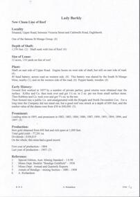
Document - LADY BARKLY MINE - NOTES ON THE LADY BARKLY MINE
One hand written and four typed copies of notes on the Lady Barkly Mine on the New Chum Line of Reef. Hand written copy has a small hand drawn locality map and a reference list attached. Notes include localilty, depth of shaft, size of lease, Plant. Battery was shared by The South St Mungo Mine, Early History, Prominence, Production and Reference. First year of production 1864 and last year of production 1907. One typed copy signed by A Richardson 29 Harrison St Bendigo. 4 typewritten copies not scanned.document, gold, lady barkly mine, lady barkly mine, st mungo group, snobs' hill, sadowa shaft, st mungo shaft, lady barkly, special edition aust. mining standard 1/6/99, mines dept booklet 'bendigo goldfield 1936, mines dept annual and quarterly reports, annalso fbendigo mining section 1880 - 1908, a richardson, kilfoy and co, robbins & co, ringale and north devonshire cos -
Bendigo Historical Society Inc.
Document - KOCH'S PIONEER QUARTZ MINING AND CRUSHING COMPANY, NO LIABILITY - SHARE CERTIFICATE
... MINING Parish Map koch's pioneer Koch's Pioneer Quartz Mining ...Koch's Pioneer Quartz Mining and Crushing Company, No Liability Long Gully Bendigo Share Certificate. Distinctive Numbers 48164 to 48213 in the name of William Grattan of St Kilda. Certificate Number 2930. Dated 7th December 1911. Signed by ?, Hugh Boyd, Directors and J. H. Craig, Manager. On the back is a map of the lease showing where the shaft is and a measurement of 450 yards from one side of the lease to the other beside the shaft. The lease is an irregular shape. Adjoining leases mentioned are Windmill Hill Co., G. Lansell's Sandhurst Mine, Cornish United Co. and the Hercules & Energetic Co. Arthur T. Walker, M. S. printed at the bottom.mining, parish map, koch's pioneer, koch's pioneer quartz mining and crushing company, no liability, koch's pioneer quartz mining and crushing company, no liability share certificate, william grattan, hugh boyd, j h craig, arthur t walker, windmill hill co., g lansell's sandhurst mine, cornish united co., hercules & energetic co. -
Bendigo Historical Society Inc.
Map - HUSTLER'S & CHRISTMAS LINES OF REEFS - PLAN OF LINES OF SECTION OF REEFS
... MINING Parish Map Hustler's & Christmas Lines of Reefs Plan ...Underground Survey of Mines Bendigo. Plan of Cross Section Lines Shewing Connections with Trigonometrical Stations and Base Lines. 13/3/99 Signed ? Stirling. Places and mines mentioned Speciman Hill, Tambour Major, Lansell's 180, Victory and Pandora, Great Extended Hustler's, Windmill Hill on Victoria Reef. Next part of map is a Plan of Lines of Section between the Hustler's and Christmas Lines of Reefs. 8/3/99. Signed ?. Transverse Section. Shows Tambour Major Co., near the Christmas Line of Reef, Crosscuts and their depth, geological features and stone encountered. Then shows Thistle Line, Charshalton Line, Napoleon Line, Nell Gwynne Line, New Chum Line, Lansell's No 180 with levels, depths and geological features. Drawing is continued in three parts to fit on paper. Lansell's East Shaft with levels and depths, geological features and stone encountered. Sheepshead Line, Old Shaft, Garden Gully Line, Victory and Pabndora Co with crosscuts, depths, geological features and stone encountered. Paddy's Gully Line, Derby Line, Millers Line, Hustler's Line, Great Extended Hustler's Co with levels, depths, geological features and stone encountered. A note beside a Saddle Reef: 360,000 pounds paid in dividends from this reef. Average ounces per ton gold noted where found. Reference Table for stone and geological features. Datum Line 700 feet above Sea Level Unscannedmining, parish map, hustler's & christmas lines of reefs, plan of lines of section of reefs, ? stirling, specimen hill, tambour major, lansell's 180, victory & pandora, great extended hustler's, windmill hill, victoria reef, tambour major co, christmas line, hustler's line, thistle line, carshalton line, napoleon line, nell gwynne line, new chum line, lansell's no 180, lansell's east shaft, sheepshead line, old shaft, garden gully line, paddy's gully line, derby line, miller's line, hustler's line, great extended hustler's co -
Bendigo Historical Society Inc.
Document - HUSTLERS REEF - NOTES ON HUSTLERS REEF
... MINING Parish Map hustler's reef Hustlers Reef Hustlers Reef No 1 ...Notes written in red pen: Ref: B. M. L Hustlers Reef No 1 Page 269. Ironbark Co. 200'. 1857 -'64. (Latham & Watson's Trib. Working Party - see Eclipse Co 28 - 2 - 1865. 200' 1857 - 1859.mining, parish map, hustler's reef, hustlers reef, hustlers reef no 1, ironbark co., latham & watson's trib., eclipse co. -
Bendigo Historical Society Inc.
Map - GREAT EXTENDED HUSTLER'S MINE - LONGITUDINAL SECTION OF THE GREAT EXTENDED HUSTLER'S MINE
... MINING Parish Map Great Extended Hustler's Mine Longitudinal ...Longitudinal Section of the Great Extended Hustler's Mine on the Hustler's Line of Reefs. Bulletin No 33, Plate No XIII. Map shows the Hustler's Tribute, 2 Old Shafts, Great Extended Hustler's Shaft, Latham & Watson's Shaft and Ironbark Gully. Datum Line 750 feet above Sea Level. Poppet Legs on the surface and Sill of Shaft 788.99 feet above Sea Level. Levels and their depths are shown and some geographical features. Some amounts of gold mined mentioned. Geological Survey of Victoria emblem and signed by H A Whitelaw, Underground Survey Office Bendigo, September 1913. Note - Plates 4, 8, 13,20, 26 & 31 form a Longitudinal Section from Fortuna Hustlers to Hustler's Consols Mine. This item has not been scanned or photographed.mining, parish map, great extended hustler's mine, longitudinal section of the great extended hustler's mine, geological survey of victoria, underground survey office bendigo, h a whitelaw, hustler's tribute, old shaft, great extended hustler's shaft, latham & watson's shaft, ironbark gully -
Bendigo Historical Society Inc.
Map - GREAT EXTENDED HUSTLER'S MINE - TRANSVERSE SECTION OF THE GREAT EXTENDED HUSTLER'S MINE
... MINING Parish Map Great Extended Hustler's Mine Transverse ...Transverse Section of the Great Extended Hustler's Mine on the Hustler's Line of Reef. Bulletin No 33, Plate No XII. Shows Poppet legs at the surface and Sill of Shaft at 788.99 feet above Sea Level, Cross Cuts and their depths, stone and geographical features encountered and their references and a number of enlarged drawing of sections of the cross cuts, Geological Survey of Victoria emblem and signed by H A Whitelaw, Underground Survey Office Bendigo, September 1913. The depths of crosscuts to No 21 were taken from plans of surveys by Mr Walker and Mr Craven, noted under Reference. Another note: This Saddle Reef is sketched from Mr Walker's plan. Dividends amounting to 360,000 pounds were obtained from it. This item has not been scanned or photographed.mining, parish map, great extended hustler's mine, transverse section of the great extended hustler's mine, old shaft, mr walker, mr craven, geological survey of victoria, underground survey office bendigo, h a whitelaw -
 Bendigo Historical Society Inc.
Map - GREAT EXTENDED HUSTLER'S MINE - PLAN OF THE GREAT EXTENDED HUSTLER'S MINE
... MINING Parish Map Great Extended Hustler's Mine No 2 Shaft Latham ...Plan of the Great Extended Hustler's Mine. Bulletin No 33, Plate No XI. Shows No 2 Shaft, Latham & Watson's Shaft, levels and their depths and some geographical features. Geographical Survey of Victoria emblem and signed by H A Whitelaw, Underground Survey Office, Bendigo, September 1913. Has reference to photos.mining, parish map, great extended hustler's mine, no 2 shaft, latham & watson's shaft, geological survey of victoria, underground survey office bendigo, h a whitelaw -
 Bendigo Historical Society Inc.
Map - GREAT EXTENDED HUSTLER'S MINE - PLAN OF THE GREAT EXTENDED HUSTLER'S MINE
... MINING Parish Map Great Extended Hustler's Mine Hustler's Line ...Plan of the Great Extended Hustler's Mine on the Hustler's Line of Reefs, Bendigo. Bulletin No 33, Plate No X. Lease No 7382. Plan has map of streets. Mine was located in the block bounded by Langston and Anderson Streets and was between the Hustler's Anticline at Surface and the Lightning Hill Anticline at Surface. Latham & Watson's Shaft is also mentioned. Levels are numbered and a table shows the Levels and their Depths. Geological Survey of Victoria. Signed by H A Whitelaw, Underground Suyrvey Office, Bendigo, September 1913. This item has not been scanned or photographed.mining, parish map, great extended hustler's mine, hustler's line of reefs, mining lease no 7382, geological survey of victoria, underground survey office bendigo, h a whitelaw, latham & watson's shaft -
Bendigo Historical Society Inc.
Map - FORTUNA HUSTLER'S MINE - TRANSVERSE SECTION OF THE FORTUNA HUSTLER'S MINE
... MINING Parish Map Fortuna Hustler's Mine Hustler's Line of Reef ...Transverse Section of the Fortuna Hustler's Mine on the Hustler's Line of Reef, Bendigo. Bulletin No 33, Plate No III. Drawing shows poppet legs on the surface and Sill of Shaft 745.38 feet above Sea Level. Shows levels and their depths, geographical features and stone encountered. Reference table to stone and geographical features. Geographical Survey of Victoria emblem. Signed by H A Whitelaw, Underground Survey Office, Bendigo. This item has not been scanned or photographed.mining, parish map, fortuna hustler's mine, hustler's line of reef, geological survey of victoria, underground survey office bendigo, h a whitelaw -
 Bendigo Historical Society Inc.
Map - FORTUNA HUSTLER'S MINE - LONGITUDINAL SECTION OF THE FORTUNA HUSTLER'S MINE
... MINING Parish Map Fortuna Hustler's Mine Longitudinal Section ...Longitudinal Section of the Fortuna Hustler's Mine on the Hustler's Line of Reef, Bendigo. Bulletin No 33, Plate No IV. Shows poppet legs at the surface level, Datum Line 750 feet above Sea Level, levels and their depths, the amount of gold per ton and some geographical features. Geological Survey of Victoria emblem and signed by H A Whitelaw, Underground Survey Office, Bendigo. Note - Plates 4, 8, 13, 20, 26 & 31 form a Longitudinal Section from Fortuna Hustler's to Hustler's Consols Mine. This item has not been scanned or photographed.mining, parish map, fortuna hustler's mine, longitudinal section of the fortuna hustler's mine, geological survey of victoria, h a whitelaw, underground survey office bendigo, hustler's line of reef, hustler's consols mine -
 Bendigo Historical Society Inc.
Map - FORTUNA HUSTLER'S MINE - PLAN OF THE FORTUNA HUSTLER'S MINE
... MINING Parish Map Fortuna Hustler's Mine Plan of the Fortuna ...Plan of the Fortuna Hustler's Mine, Bulletin No 33, Plate No II. Geological Survey of Victoria. Signed by H A Whitelaw, Underground Survey Office Bendigo, September 1913. Map shows levels and depths. There are smaller drawings of some sections of some levels. This item has not been scanned or photographed.mining, parish map, fortuna hustler's mine, plan of the fortuna hustler's mine, geological survey of victoria, h a whitelaw, underground survey office bendigo -
Bendigo Historical Society Inc.
Map - HUSTLER'S CONSOLS MINE - TRANSVERSE SECTION OF THE HUSTLER'S CONSOLS MINE
... MINING Parish Map Hustler's Consols Mine Transverse Section ...Transverse Section of the Hustler's Consols Mine Bulletin No 33, Plate No XXXIII. Map shows poppet legs at the surface and Sill of Shaft 779.42 feet above Sea Level. Shows the different levels and their depths and the different stone and geographical features encountered. Has larger drawing of Section A - B. Geographical Survey of Victoria. Signed by H A Whitelaw, Underground Survey Office Bendigo, September 1913. This Item has not been scanned or Photographed.mining, parish map, hustler's consols mine, transverse section of the hustler's consols mine, geological survey of victoria, underground survey office bendigo, h a whitelaw -
Bendigo Historical Society Inc.
Map - HUSTLER'S REEF MINE - TRANSVERSE SECTION OF THE HUSTLER'S REEF MINE
... MINING Parish Map Hustler's Reef Mine transverse Section ...Transverse Section of the Hustler's Reef Mine on the Hustler's Line of Reefs. Bulletin No 33, Plate No XVIII. Shows cross-cuts and their depth, different types of stone and geological features encountered. Drawing of poppet legs at the surface and Sill of Shaft 756.39 ft above Sea Level. Reference Table shows key to the different stone and geographical features encountered. Geographical Survey of Victoria. Signed by H A Whitelaw, Underground Survey Office, Bendigo, September 1913. Thompson's Reef is also mentioned on the map. This item has not been scanned or photographed.mining, parish map, hustler's reef mine, transverse section of the hustler's reef mine, geological survey of victoria, h a whitelaw, underground survey office bendigo, thompson's reef. -
 Bendigo Historical Society Inc.
Map - HUSTLER'S REEF MINE - EAST & WEST CROSS-CUTS, NORTH & SOUTH OF SHAFT
... MINING Parish Map Hustler's Reef Mine East & West Cross-cuts ...East & West Cross-cuts, North & South of Shaft, Hustler's Reef Mine Bulletin No 33, Plate No XIX. Map shows main shaft and smaller drawing of section with different stone encountered. Also gives location in relation to the shaft, e. g. 225'E & 150'S of Shaft. Reference diagram to show the different stone and features encountered. Geological Survey of Victoria emblem. Signed by H A Whitelaw, Underground Survey Office Bendigo, September 1913. This item has not been scanned or photographed.mining, parish map, hustler's reef mine, east & west cross-cuts north & south of shaft, geological survey of victoria, h a whitelaw, underground survey office bendigo -
Bendigo Historical Society Inc.
Map - HUSTLER'S REEF & HUSTLER'S REEF NO 1 MINES - LONGITUDINAL SECTION OF THE HUSTLER'S REEF & HUSTLER'S
... MINING Parish Map Hustler's Reef & Hustler's Reef No 1 Mines ...Longitudinal Section of the Hustler's Reef & Hustler's Reef No 1 Mines on the Hustler's Line of Reef. Bulletin No 33, Plate No XX. Note - Plates 4, 8, 13, 20, 26 & 31 form a Longitudinal Section from Fortuna Hustler's to Hustler's Consols Mine. Geological Survey of Victoria emblem. Signed by H A Whitelaw, Underground Survey Office Bendigo, September 1913. Shows the two shafts with their levels and depths. Also shows geographical features and yields of gold and amalgam per ton. This item has not been scanned or photographed.mining, parish map, hustler's reef & hustler's reef no 1 mines, longitudinal section of the hustler's reef & hustler's reef no 1 mines, geographical survey of victoria, underground survey office bendigo, h a whitelaw -
Bendigo Historical Society Inc.
Map - HUSTLER'S REEF & HUSTLER'S REEF NO 1 MINES - PLAN OF THE HUSTLER'S REEF & HUSTLER'S REEF NO 1 MINES
... MINING Parish Map Hustler's Reef & Hustler's Reef No 1 Mines Plan ...Plan of the Hustler's Reef & Hustler's Reef No 1 Mines on the Hustler's Line of Reefs Bulletin No 33, Plate No XVII. Two drawings with different levels on each for clarity. Shows depth and some geographical features.Geological Survey of Victoria emblem. Signed by H A Whitelaw Underground Survey Office Bendigo, September 1913. This item has not been scanned or photographed.mining, parish map, hustler's reef & hustler's reef no 1 mines, plan of the hustler's reef & hustler's reef no 1 mines, hustler's line of reefs, geological survey of victoria, underground survey office bendigo, h a whitelaw -
Bendigo Historical Society Inc.
Map - HUSTLER'S REEF & HUSTLER'S REEF NO 1 MINES - PLAN OF THE HUSTLER'S REEF & HUSTLER'S REEF NO 1 MINES
... MINING Parish Map Hustler's Reef & Hustler's Reef No 1 Mines Plan ...Plan of the Hustler's Reef & Hustler's Reef No 1 Mines on the Hustler's Line of Reefs, Bendigo Bulletin No 33, Plate No XIV. No 8 connecting No 10 (Hustler's Reef), No 11 connecting No 13 (Hustler's Reef), No 13 (Hustler's Reef No 1) connecting No 15 (Hustler's Reef) and No 10 Hustler's Reef No 1 rise to Comet Mine. Map shows different levels in relation to the two shafts, the lines of the Hustler's Line of Reefs and the Lightning Hill Line of Reefs, the approximate Boundary of Lease and the Comet Co., the adjoining lease. Table on the left shows the levels and their depths of the two mines. Signed by H A Whitelaw, Underground Survey Office, Bendigo, September 1913. Geological Survey of Victoria emblem. This item has not been scanned or photographed.mining, parish map, hustler's reef & hustler's reef no 1 mines, plan of the hustler's reef & hustler's reef no 1 mines, hustler's line of reefs lightning hill line of reefs, comet co., h a whitelaw, underground survey office bendigo, geological survey of victoria -
Bendigo Historical Society Inc.
Map - HUSTLER'S REEF & HUSTLER'S REEF NO 1 MINES - PLAN OF THE HUSTLER'S REEF & HUSTLER'S REEF NO 1 MINES
... MINING Parish Map Hustler's Reef & Hustler's Reef No 1 Mines ...Plan of the Hustler's Reef & Hustler's Reef No 1 Mines on the Hustler's Line of Reefs, Bendigo Bulletin No 33, Plate No XVI. Plan shows the two shafts and the levels in relation to it. No 9 Level 896 feet 9 inches connecting No 10 Level at 867 feet 2 inches. Plan shows depth of levels and geographical features. Signed by H A Whitelaw, Underground Survey Office, Bendigo. Geographical Survey of Victoria emblem.mining, parish map, hustler's reef & hustler's reef no 1 mines, hustler's line of reefs, plan of the hustler's reef & hustler's reef no 1 mines, h a whitelaw, underground survey office bendigo, geographical survey of victoria, mining -
Bendigo Historical Society Inc.
Map - HUSTLER'S REEF & HUSTLER'S REEF NO 1 MINES - PLAN OF THE HUSTLER'S REEF & HUSTLER'S REEF NO 1 MINES
... MINING Parish Map Hustler's Reef & Hustler's Reef No 1 Mines Plan ...Plan of the Hustler's Reef & Hustler's Reef No 1 Mines on the Hustler's Line of Reefs Bulletin No 33, Plate No XV. Plan shows the two mines with depth of levels, geological features and levels in relation to the shaft. Geological Survey of Victoria emblem and signed by H A Whitelaw, Underground Survey Office Bendigo, September 1913. Note - The Lease Boundaries shown on this plan are only in their approximate relative positions to Nos 13, Intermediate and 14 Levels of the Hustler's Reef No 1 workings, and Nos 15, 16 and 17 Levels of the Hustler's Reef workings.mining, parish map, hustler's reef & hustler's reef no 1 mines, plan of the hustler's reef & hustler's reef no 1 mines, geological survey of victoria, underground survey office bendigo, h a whitelaw, hustler's line of reefs -
Bendigo Historical Society Inc.
Map - HUSTLER'S REEF NO 1 MINE - EAST & WEST CROSS-CUTS OF THE HUSTLER'S REEF NO 1 MINE
... MINING Parish Map Hustler's Reef No 1 Mine East & West Cross-cuts ...Map showing the East & West Cross-cuts, North & South of Shaft of the Hustler's Reef No 1 Mine on the Hustler's Line of Reefs Bulletin No 33, Plate No XXII. Drawing shows where the different levels are, the stone encountered and smaller drawings of other sections near the shaft. Also shows some geographical features. Signed by H A Whitelaw, Underground Survey Office Bendigo, September, 1913. Geological Survey of Victoria emblem .mining, parish map, hustler's reef no 1 mine, east & west cross-cuts of the hustler's reef no 1 mine, geological survey of victoria, h a whitelaw, underground survey office bendigo, hustler's line of reefs -
Bendigo Historical Society Inc.
Map - HUSTLER'S REEF NO 1 MINE - TRANSVERSE SECTION OF THE HUSTLER'S REEF NO 1 MINE
... MINING Parish Map Hustler's Reef No 1 Mine Hustler's Line ...Map of a transverse Section of the Hustler's Reef No 1 Mine on the hustler's Line of Reefs Bulletin No 33, Plate No XXI. Map shows poppet legs at 801.07 feet above Sea Level and drawing of shaft with the different levels. Also shown are geological features and stone encountered. Geological Survey of Victoria emblem H Herman, Director, W Dickson, Secretary of Mines and The Hon. J. Drysdale Brown MLC Minister of Mines. Signed by H S Whitelaw, Underground Survey Office Bendigo, September, 1913. This item has not been scanned or photographed.mining, parish map, hustler's reef no 1 mine, hustler's line of reefs, transverse section of the hustler's reef no 1 mine, geological survey of victoria, underground survey office bendigo, h s whitelaw, h herman, w dickson, the hon j drysdale brown -
Bendigo Historical Society Inc.
Map - MAP: VICTORIA MINING DISTRICTS, MINING DIVISIONS AND THE GOLD FIELDS, 1866
... MAP: VICTORIA MINING DISTRICTS, MINING DIVISIONS AND THE.... Hayward 1st. December, 1950. Map MAP: VICTORIA MINING DISTRICTS ...Map: printed map stuck on backing paper ( waxed ? ) to support material. Shows mining districts, divisions and goldfields of Victoria. Printed in blue ink on bottom ' this map compiled in 1866. Printed in 1869.' Printed on bottom ' engraved by William Slight under the direction of R. Brough Smyth FGS Lon., the Hon John Macgregor MLA Minister of Mines, published 24th. October, 1866. Revised and corrected by Arthur Everitt, January 25th. 1869. On back of map ' this mapp was compiled by the Mines Department of Victoria 24th. October 1866, corrected by Arthur Everett 15th. January 1869. Presented to the Bendigo Historical Society by E. Hayward 1st. December, 1950.map, victoria, victoria, bendigo, goldfields, gold reefs, mining divisions, map -
 Bendigo Historical Society Inc.
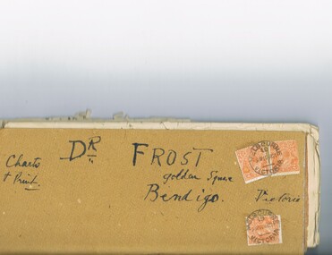
Document - MCCOLL, RANKIN AND STANISTREET COLLECTION: DR FROST, 1920
Correspondence to Dr. Frost re Badak Tin Mine. Binti Binti, Sweet Nell, Bettina, Mascotte & Maconi. Report on inspection of mine reports by Mr. M. Sheard (Mine Manager) & Dr. C. W. Laver of Kalgoorlie, map of Binti lease. Des Frost Golden Square Bendigo Victoria, charts and print.MCCOLL RANKIN & STANISTREETorganization, business, gold mining, mccoll rankin & stanistreet -
Bendigo Historical Society Inc.
Map - HUSTLER'S ROYAL RESERVE NO 2 CO. - LONGITUDINAL SECTION OF THE HUSTLER'S ROYAL RESERVE NO 2 CO
... MINING Parish Map Hustler's Royal Reserve No 2 Longitudinal ...Longitudinal Section of the Hustler's Royal Reserve No 2 Co. on the Hustler's Line of Reef Bulletin No 33, Plate No VIII. Note - Plates 4, 8, 13, 20, 26 & 31 form a Longutudinal Section from Fortuna Hustler's to Hustler's Consols Mine. Mines mentioned are the Hustler's Royal Reserve No 2 Main Shaft, Hustler's Royal Reserve No 2 Park Shaft, Royal Hustler's, Imperial Hustler's, Great Extended Hustler's Freehold and the Great Extended. Section shows depth of levels, datum lines and height of sill above sea levelyield in ozs od gold. Geological Survey of Victoria emblem. H. Herman, Director, W. Dickson, Secretary for Mines and The Hon. J. Drysdale Brown MLC, Minister for Mines and signed by H S Whitelaw, Underground Survey Office Bendigo, September 1913. This item has not been scanned or photographed.mining, parish map, hustler's royal reserve no 2, longitudinal section of the hustler's royal reserve no 2 co, hustler's royal reserve no 2 (main shaft), hustler's royal reserve no 2 (park shaft), royal hustler's, imperial hustler's, great extended hustler's freehold, great extended, geological survey of victoria, underground survey office bendigo, h s whitelaw, h herman, w dickson, the hon j drysdale brown