Showing 265 items
matching mining box
-
 Ballarat Heritage Services
Photograph, Mullock Heap In Victoria Park, Ballarat, 2014, 04/11/2014
The large mullock heap, marks the site of a former quartz mine, and is one of the few visible signs of the former presence of extensive gold mining activities in this area of Ballarat. Originally known as Park Mine, and now known as Mount Holled Smith, the mine associated with this mullock heap puddled 750 tons of washdirt each day. The mine closed down in 1874, at which time 94,699 ounces of gold had been removed from the ground. Colour photograph of a mullock heap in Ballarat's Victoria Park.mullock heap, ballarat gardens, victoria park, park mine -
 Ballarat Heritage Services
Photograph - Photograph - Colour, Clare Gervasoni, Tarilta, 2017, 16/07/2017
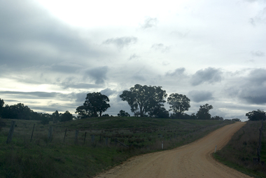
Tarilta is a rural locality and former gold-mining town 12 km south of Castlemaine, 4 km north-west of Guildford and 3 km north-east of Vaughan. The last gold mining activity took place around the 1880s. It was originally Kangaroo Flat, being located where the Kangaroo Creek enters the Loddon River. It was surveyed and named in 1864. Gold was discovered at Tarilta in 1853. The Tarilta School was opened in 1860 in a Wesleyan chapel, and closed i n1925. In 1864 a township was surveyed and named Tarilta, the word being derived from an Aboriginal expression thought to mean kangaroo. In 1865 Bailliere’s Victorian gazetteer described Tarilta as being an alluvial and quartz gold-mining town with three quartz-crushing mills, three horse-puddling machines and two hotels. The elevated nature of the land around Tarilta made it accessible only by horse and dray, or on horseback. Colour photograph of Tarilta in Central Victoria. tarilta, central victoria, landcape -
 Ballarat Heritage Services
Photograph - Colour, Clare Gervasoni, White Night Ballarat, 2017, 04/03/2017
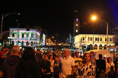
Images of White Night Ballarat which lit up buildings in Lydiard Street Ballarat.white night, white night ballarat, projection, lydiard street, post office gallery, ballarat, ballarat mining exchange, craig's royal hotel, ballarat, lydiard street, ballarat, sturt street, ballarat, former bank of new south wales, ballarat -
 Ballarat Heritage Services
Photograph - Colour, Clare Gervasoni, Port Phillip Mine, Clunes, 2006, 07/12/2006
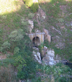
Remains of an arch structure on the site of the Port Phillip Mine at Clunes, Victoria.port phillip mine, clunes, mining -
 Ballarat Heritage Services
Photograph - Photograph - Colour, Ballarat Mining Exchange, 2008, 26/04/2008
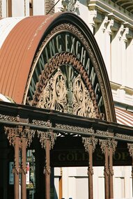
When it was decided to replace the verandah at the Mining Exchange the large detailed piece was found in a junk yard. The pillars were caste in Castlemaine from one remaining original pillar.Colour photograph of the wrought iron at the front of the Ballarat Mining Exchange.ballarat mining exchange, wrought iron, verandah -
 Ballarat Heritage Services
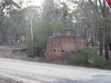
Photograph - Photograph - Colour, Steele's Pioneer Mine Ruins, Yandoit, 2016, 18/01/2016
Steele's Reef was opened in 1859 along with a number of other reefs in the Yandoit area. The reef was worked by small mining parties until the late 1880s. In 1887, the Steele's Reef Quartz Mining Company fixed steam pumping machinery and commenced sinking a shaft. The company were unable to find a profitable ore body and after two years work closed down. By this time their shaft had reached a depth of 150 feet. The mine was then taken over by the Pioneer Quartz Mining Company who appear not to have worked the mine. In 1906, the Steele's Pioneer Company commenced work, erecting a winding winch at the old shaft sunk by the Steele's Company. The next year the company erected a 10-head battery, set of poppet legs, a pumping engine. Sinking the shaft a further 100 feet, the company struggled to find payable ore and soon closed down.Colour photographs of the remnants of Steele's mine at Yandoit, Victoria. steele's mine, yandoit, mining, ruins -
 City of Ballarat Libraries
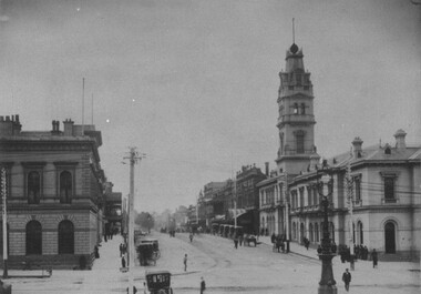
Card Box Photographs, View north along Lydiard Street North, Ballarat 1899
Taken from Sturt Street. The Post Office and Mining Exchange can be seen. There are also Horse Drawn Cabs parked at a rank. The Streetlight stands in the intersection of Sturt and Lydiard Streets.lydiard street north, ballarat, sturt street, post office, mining exchange, horse drawn cabs, streetlight, commercial, streetscape -
 City of Ballarat Libraries
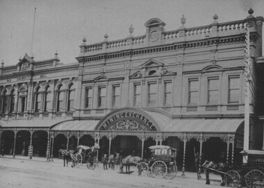
Card Box Photographs, Mining Exchange, Ballarat 1899
Horse Drawn Cabs parked outside of the Mining Exchange, Lydiard Street North. The striped veranda, iron frieze and barbers pole can be seen. Another feature in this photograph is The Old Colonist's Hall. mining exchange, ballarat, lydiard street north, old colonist's hall, horse drawn cab, building, commercial -
 City of Ballarat Libraries
Photograph - Card Box Photographs, Former residence of Walter Davis, Ballarat c1950
This building in Victoria Street has ornamental brickwork, iron frieze balustrade, leadlight and chimney bay windows. It has been used as the Teachers College residence and thought to have been built by mining speculator, Forbes.victoria street, ballarat, private dwelling, building, walter davis, teachers college, forbes -
 City of Ballarat Libraries
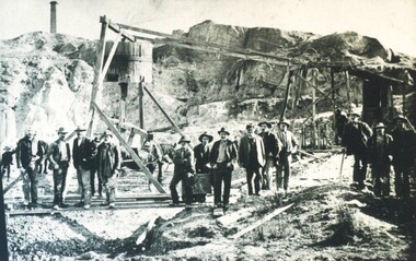
Photograph - Card Box Photographs, Miners at Black Hill, Ballarat circa 1908
Group of 16 miners possibly at the Blue Ribband Mine. A Chilean Horse Whim can be seen in the background.black hill, mining, blue ribband mine, horse whim, people, miners -
 City of Ballarat Libraries
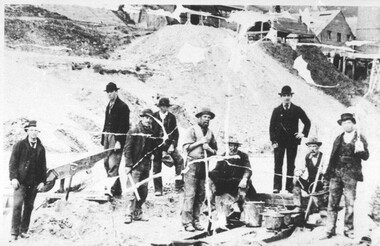
Photograph - Card Box Photographs, Mining for Pyrite, Black Hill circa 1908
Group of 9 miners catching pyrite in creek run off from the Battery located at the south end of Black Hill.mining, battery, miners, pyrite, black hill -
 City of Ballarat Libraries
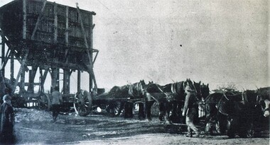
Photograph - Card Box Photographs, Delaland Brothers Removalists, Ballarat 1908
Horse team shifting 60 tonne hopper from Central No. 1 to No. 2 mine.delaland brothers, mining, central mine, vehicle, work, ballarat -
 City of Ballarat Libraries
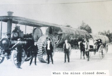
Photograph - Card Box Photographs, Traction engines moving boilers when the mines closed down, Sebastopol circa 1916
traction engine, mining, vehicles, persons, sebastopol, boilers -
 City of Ballarat Libraries
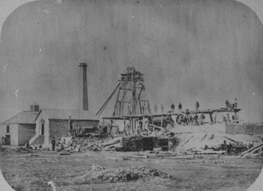
Photograph - Card Box Photographs, Prince of Wales Mine, Sebastopol circa 1865
prince of wales mine, sebastopol, mining, building, poppet head -
 City of Ballarat Libraries
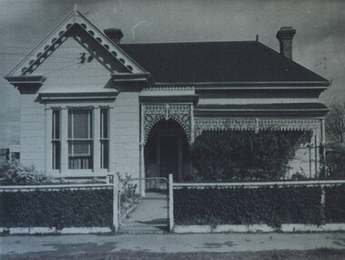
Photograph - Card Box Photographs, South Star Mine Manager's House, Sebastopol circa 1950
Located on Albert Street, the house was built in the 1880s. The Duke of York changed clothes in this house prior to a trip down the mine.south star mine, duke of york, building, gardens, albert street, mining -
 City of Ballarat Libraries
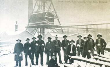
Postcard - Card Box Photographs, Snow scene Last Chance Goldmine, Ballarat circa 1900
last chance gold mine, mining, persons, costume, ballarat -
 City of Ballarat Libraries
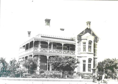
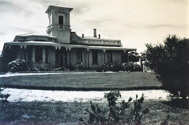
Photograph - Card Box Photographs, Villa Maria, Ballarat circa 1940
The villa was built by mining speculator, Mr Fortune and it became know as 'Fortune's Folly'. The tower was added by Joshua Gregory, a well-to-do grocer originally from Hertfordshire. The Sisters of Mercy acquired the building in 1902. villa maria, melbourne road, fortune street, joshua gregory, sisters of mercy, building, public -
 City of Ballarat Libraries
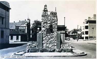
Postcard - Card Box Photographs, Gold Cairn, Ballarat circa 1951
Located on Sturt Street in front of Parent Place. Valentine Series V 42.gold cairn, monument, mining, sturt street, public -
 City of Ballarat Libraries
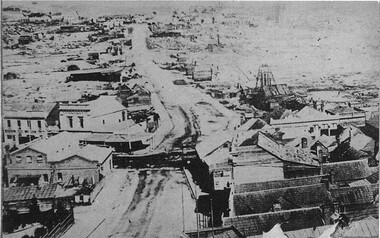
Photograph - Card Box Photographs, View south along Barkly Street from East Ballarat Fire Station tower
Shows the Blue Jacket Mine.east ballarat fire station, blue jacket mine, streetscape, mining, commerical -
 City of Ballarat Libraries
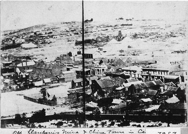
Photograph - Card Box Photographs, View from East Ballarat Fire Station tower circa 1866
Old Llanberris Mine and Chinatown in the centre.east ballarat fire station, llanberris mine, chinese settlement, mining, buildings, commerical -
 City of Ballarat Libraries
Postcard - Card Box Photographs, A Miner's Hut
Two men and a dog outside of a wood, bark and mud hut. Plate 4.building, persons, mining -
 City of Ballarat Libraries
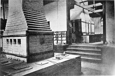
Postcard - Card Box Photographs, Possible Metallurgy Laboratory, School of Mines
school of mines, ballarat, education, mining -
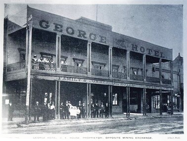 City of Ballarat Libraries
Postcard - Card Box Photographs, George Hotel, C.E. House Proprietor, Opposite the Mining Exchange
... Proprietor, Opposite the Mining Exchange. Postcard Card Box ...Chuck Photo Series.george hotel, lydiard street north, hotel, building, persons -
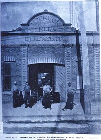 City of Ballarat Libraries
Postcard - Card Box Photographs, Works of H. Troon, 29 Armstrong Street South. General and Mining Blacksmith
... Armstrong Street South. General and Mining Blacksmith. Postcard Card ...Plate 227 Chuck Photo Series.h. troon, armstrong street south, manufacturing, building -
 Whitehorse Historical Society Inc.
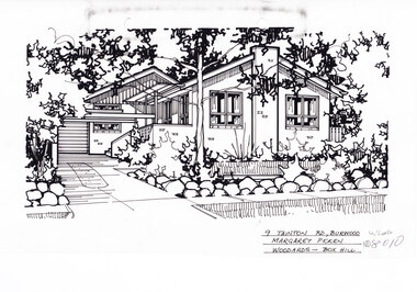
Artwork, other - Ink Line Drawing, 9 Tainton Rd., Burwood, circa 1990's
A property illustration by Margret Picken Commissioned by the real estate agency Woodards Box Hill for the purpose of advertising 9 Tainton Rd., Burwood circa 1990's Made by using Rotring ‘Rapidigraph’ drafting pens with Rotring ink on Rapidigraph polyester drafting film, double matte. This property is listed as having had unit 10 sell for $137,000 in 1990 Trained as a cartographic draftsman within the mining industry, Margaret Picken is an artist who worked producing property illustrations for real estate agencies in eastern suburbs of Victoria from 1983-2005. Retiring from the industry as technological changes favored coloured photography over illustrations, and commissioning companies over sole contractors.This artwork is of Historical Significance as a record of local domestic architecture.A black ink line drawing on drafters film by Margaret Picken, of 9 Tainton St., Burwood. A single story brick house with multiple pitched roofs, to the left is a driveway leading to a garage in the background. and in front of the house is a lawn enclosed by a low rock fence and shrubbery. There are two hole punches near the upper edge, And a black wear mark running left below the upper edge9 Tainton Rd., Burwood Margaret Picken Woodards - Box Hillwhitehorse historical society, schwerkolt cottage, housing, architecture, margaret picken, burwood, house, garden -
 Whitehorse Historical Society Inc.
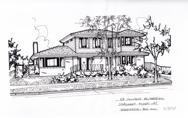
Artwork, other - Ink Line Drawing, Margaret Picken, 53 Jolimont Rd., Forest Hill, 1997
A property illustration by Margret Picken Commissioned by the real estate agency Woodards Blackburn for the purpose of advertising 53 Jolimont Rd., Forest Hill. This property is listed as having sold for $176,000 in 1997. Made by using Rotring ‘Rapidigraph’ drafting pens with Rotring ink on Rapidigraph polyester drafting film, double matte. Trained as a cartographic draftsman within the mining industry, Margaret Picken is an artist who worked producing property illustrations for real estate agencies in eastern suburbs of Victoria from 1983-2005. Retiring from the industry as technological changes favored coloured photography over illustrations, and commissioning companies over sole contractors.This artwork is of Historical Significance as a record of local domestic architecture.A black ink line drawing on drafters film by Margaret Picken, of 53 Jolimont Rd., Forest Hill, depicting a two story brick and weatherboard house set back from a front garden. There are two hole punch holes centre near the upper edge.53 Jolimont Rd., Forest Hill Margaret Picken -97 Woodards - Box Hillwhitehorse historical society, schwerkolt cottage, housing, architecture, margaret picken, house, garden, forest hill -
 Whitehorse Historical Society Inc.
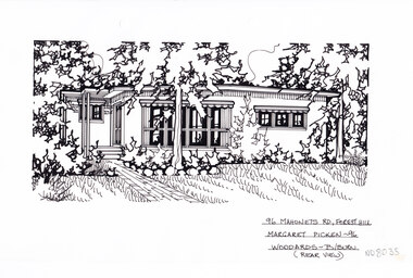
Artwork, other - Ink Line Drawing, Margaret Picken, 96 Mahoneys Rd., Forest Hill, 1997
A property illustration by Margret Picken Commissioned by the real estate agency Woodards Blackburn for the purpose of advertising 96 Mahoneys Rd., Forest Hill. This property is listed as having sold for $170,000 in 1996. Made by using Rotring ‘Rapidigraph’ drafting pens with Rotring ink on Rapidigraph polyester drafting film, double matte. Trained as a cartographic draftsman within the mining industry, Margaret Picken is an artist who worked producing property illustrations for real estate agencies in eastern suburbs of Victoria from 1983-2005. Retiring from the industry as technological changes favored coloured photography over illustrations, and commissioning companies over sole contractors.This artwork is of Historical Significance as a record of local domestic architecture.A black ink line drawing on drafters film by Margaret Picken, of 96 Mahoneys Rd., Forest Hill, featuring a brick path leading to a flat roofed single story house set back from a lawn and garden in the foreground. There are two hole punch holes centre near the upper edge. There is a 1x1.5 dried and discoloured adhesive mark 53 Jolimont Rd., Forest Hill Margaret Picken -96 Woodards - Box Hillwhitehorse historical society, schwerkolt cottage, housing, architecture, margaret picken, house, garden, forest hill -
 Whitehorse Historical Society Inc.
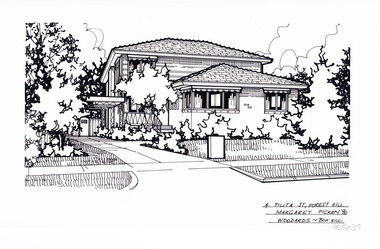
Artwork, other - Ink Line Drawing, Margaret Picken, 4 Pilita St., Forest Hill, 1990
A property illustration by Margret Picken Commissioned by the real estate agency Woodards Box Hill for the purpose of advertising 4 Pilita St., Forest Hill. Made by using Rotring ‘Rapidigraph’ drafting pens with Rotring ink on Rapidigraph polyester drafting film, double matte. Trained as a cartographic draftsman within the mining industry, Margaret Picken is an artist who worked producing property illustrations for real estate agencies in eastern suburbs of Victoria from 1983-2005. Retiring from the industry as technological changes favored coloured photography over illustrations, and commissioning companies over sole contractors.This artwork is of Historical Significance as a record of local domestic architecture.A black ink line drawing on drafters film by Margaret Picken, of 4 Pilita St., Forest Hill, a two story brick and weather board house set back from a front lawn, with a driveway leading to a connected carport. There are two hole punches centre of the upper edge4 Pilita St., Forest Hill Margaret Picken '90 Woodards - Box Hillwhitehorse historical society, schwerkolt cottage, housing, architecture, margaret picken, house, garden, forest hill -
 Ballarat Heritage Services
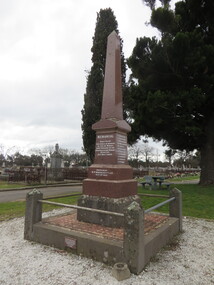
Photograph - Photograph - Colour, Clare Gervasoni, New Australasian Mine Disaster Memorial in Creswick Old Cemetery, 2018, 26/08/2018
The New Australasian Gold Mining Company's No 2 shaft was flooded on 12 December 1882, trapping 27 miners, 22 of whom died despite heroic efforts to save them. A number of photographs of the memorial to those who died in the New Australasian Mine Disaster, including names of those who died.new australasian mine disaster memorial, creswick cemetery, creswick old cemetery -
 Ballarat Heritage Services
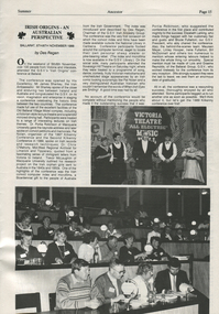
Magazine - Magazine article, Genealogical Society of Victoria, Irish Origins - An Australian Perspective, November 1988
Image (top) of Victoria Theatre Sovereign Hill, with Andrew Dark (2nd from left) and Peter Eyres (2nd from right) The theatre at Soveriegn Hill is a replica of the Victoria Theatre that opened in Ballarat on 16 February 1856 with a season by the legendary Lola Montez. The new theatre claimed to be the largest in the colony outside Melbourne.page 15 black and white typed article with two imagesIRISH ORIGINS - AN AUSTRALIAN PERSPECTIVE BALLARAT, 5TH/6TH NOVEMBER 1988 by Des Reganandrew dark, victoria theatre, sovereign hull, ballarat, gold, mining