Showing 15011 items matching "mt-joonawara"
-
 Federation University Historical Collection
Photograph, Univesity of Ballarat Mt Helen Campus Library Staffmember Helen Wiseman, c1995
The university of Ballarat was a predecesor institutionof Federation University Australia.Portrait of Univesity of Ballarat Mt Helen Campus Library Staffmember Helen Wisemanlibary, e.j. barker library, mt helen library, helen wiseman -
 Federation University Historical Collection
Photograph, Univesity of Ballarat Mt Helen Campus Library Staffmember Jan Ford, c1995
The university of Ballarat was a predecesor institutionof Federation University Australia.Portrait of Univesity of Ballarat Mt Helen Campus Library Staffmember Jan Fordlibary, e.j. barker library, mt helen library -
 Federation University Historical Collection
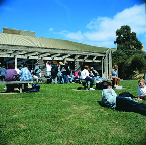
Photograph - Mt Helen Union Building, Federation University Mt Helen Campus U Building, c2005, c2005
Federation University Australia was established on 1 January 2014. Formerly known as the University of Ballarat, its enabling legislation was the University of Ballarat Amendment (Federation University Australia) Act 2013. Although formally created as a University in 1994, the University of Ballarat has a lineage back to 1870 with the establishment of the School of Mines Ballarat, making it the third institution of higher learning to be established in Australia and the first to be established in regional Australia. On 1 January 1994, Ballarat University College became the University of Ballarat and in 1998 the University merged with three TAFE Institutes to become a dual sector institution with multiple campuses. On 1 January 2014, the University of Ballarat amalgamated with the Monash University Gippsland Campus to form Federation University Australia. The Gippsland Campus also had a long lineage dating back to 1928 with the establishment of the Yallourn Technical School which became a predecessor institution to the Gippsland College of Advanced Education formed in 1968. In 1990, it was renamed the Monash University College and in 1993 became the Gippsland Campus of Monash University. In 2016, Federation University Australia announced plans to take possession, over a two-year period, of Monash’s Berwick Campus in the south-east corridor of Melbourne. Federation University Australia, or FedUni, is headquartered in Ballarat and offers programs in Higher Education and Vocational Education and Training to regional Victoria and beyond. The University’s commitment to educational and social equity, teaching excellence, research distinction, environmental sustainability and regional capacity building has enabled it to develop in a way that draws on its proud heritage to inform its future. Its regional character sets a framework for the University’s priorities but does not constrain it from serving wider community interests, nationally and internationally. The name Federation University Australia was chosen to convey the scope and capacity of an expanded regional university with a federated network of campuses.Colour photograph of students on the grass outside the Union Building on Mt Helen Campus.federation university, mount helen campus, buildings, u building, students, union building, albert coates building -
 Federation University Historical Collection
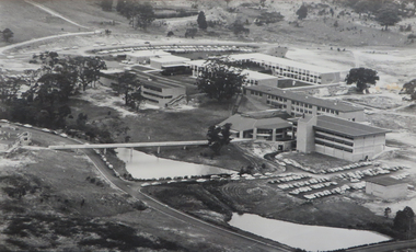
Photograph - Photograph - Black and White, Ballarat College of Advanced Education, Aerial view of the Mt Helen campus from the north, c1975
black and white photograph: Aerial view of Mt Helen campus from the north mount helen campus, mount helen campus aerial, student residences, p building, f building, g building, l building, mt helen library, union building, u building, e.j. barker library, aerial -
 Ballarat Heritage Services
Photograph - Photograph - Colour, Clare Gervasoni, Towards Mt Warrenheip, Ballarat, 29/04/2018
Colour photographooking towards Mt Warrenheip from Armstrong Street South, Ballarat.mount warrenheip, ballarat -
 Glenelg Shire Council Cultural Collection
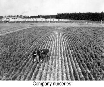
Photograph, Company Nursery, Dartmoor, n.d
Port of Portland Authority archivesFront: (no inscriptions) Back: Company Nursery, Dartmoor (upper left, pencil). 11 (lower right, pencil). Photography by The Arthur Studio. Further copies always available at 27 Commercial St. East, Mt. Gambier (lower right, purple stamp).port of portland -
 Kiewa Valley Historical Society
Postcard Circa 1950, Mt. Beauty Village, Kiewa Hydro-Electricity Project, circa 1950
This postcard was produced in the 1950's for the tourist trade in the Kiewa Valley and Alpine region. It encompasses the period when the State of Victoria was pressured by the ever increasing demand by industry and its population for electricity supplies. Hydro electricity was seen as an untapped natural resource to quench this demand. The Victorian Alps and the rivers flowing into its valleys was ideal for the construction of the Kiewa Hydro Electricity Scheme. The late 1940's saw the development of this scheme and the changing of sections of alpine landscape is covered by this and other postcards/pictures (tourists, construction workers, and established rural populations). This period in time was before the established wildlife and forest/nature groups became political activist who changed legislative acts to protect the environment. The regulatory pondage on the northern aspect of the village had no water over-spill from the unfinished power station.This rural region in 1950 (Kiewa Valley/alpine plains) was at most only significant to a smaller group of winter sports, summer hikers/horse riders and rural farmers/graziers. The numbers of tourists and the increase in the local resident population was boosted by the construction of the Hydro Electricity Scheme. This influx to the regional population resulted in a corresponding diversity in services and brought about an environment that responded to a growing level of tourists and thereby permitting this industry to grow more rapidly than it would have naturally. This postcard details an attraction to the "cleaner" method of providing electricity. This postcard was purchased in 1950 by a surveyor at Landford's Gap. The couple shown in this photograph would have been employed by the S.E.C. under the Kiewa Hydro-Electricity Scheme.This item is a scanned black and white photograph of a panoramic view of Mount Beauty Village in 1950 (a closed village, entry by pass only). The regulatory pondage has earthen walls but no water.See 0480 (A) -(D) and (F) for other photos of similar postcards"MT. BEAUTY VILLAGE KIEWA HYDRO-ELECTRIC PROJECT"kiewa valley tourism, victorian alps, alternate energy supplies, alpine population growth -
 Mt Dandenong & District Historical Society Inc.
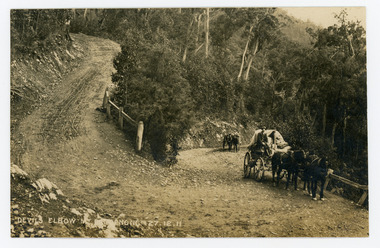
Photograph, Devils Elbow Mt Dandenong 27.12.1911, 1911
Original postcard showing two wagons coming up the hill to round the Devil's Elbow, scene of a wagon disaster where a wagon and horses went over the side on December 27th 1911. The first wagon is pulled by three horses and the second one horse with a man leading it.On front of postcard: DEVILS ELBOW MT DANDENONG 27.12.1911wagon, wagonette, devil's elbow, devils elbow, coach road, old coach road, mt dandenong -
 Buninyong & District Historical Society
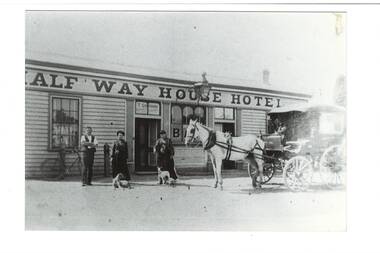
Photograph - B/W photograph, Half Way House, Mt. Clear, 1988
Lost buildingB?W photo, Half way House Mt. Clear, (on site of new church at Mt Clear) licensee T. Gordan and two women in front, two dogs and a horse and carriage, prominent sign across front of buildinghotel, mt clear, half way house hotel -
 Glenelg Shire Council Cultural Collection
Photograph - Photograph - Timber treatment plant, Dartmoor, n.d
Port of Portland Authority archives.Front: (no inscriptions) Back: Inside Timber Treatment Plant Dartmoor (upper left, pencil). Photography by The Arthur Studio. Further copies always obtainable at 27 Commercial St. East, Mt Gambier. (lower right purple stamp), (10 lower right, pencil).port of portland archives -
 Federation University Historical Collection
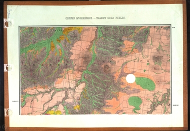
Map, Clunes, Mt Greenock, and Talbot Gold Fields, 1883, 1883
A geological plan of the Clunes, Mt Greenock, and Talbot Gold Fields in two parts. .1) This section of the map includes Talbot, Talbot water supply race, Mt Glasgow, Little Green Hill, Middle Hill, Mt Cameron, Ballarat Hill, Bakery Hill, Goodwoman Hill, Scandanavian Lead, Eglinton Swamp, McCallum's Creek, Tullaroop Creek, Dunach, Maryborough Railway, Middle Creek and includes many mines such as Rip Van Winkel, Union Extended, South Greenock, Nicholl's Freehold. .2) This section of the map includes McCallums, Clunes, Green Hill, Mt Beckworth, Mt Gap, Maryborough Reservoir, and includes mines such as Lothair, Bute, Clyde, Clunes Consols, London and Australian, Oriental,clunes, talbot, water supply, railway, geology -
 Federation University Historical Collection
Photograph, Mt Helen Student Residences, c1980s, 1990s
Colour photograph of the interior of the kitchen in one of the Mt Helen St13.0 x udent Residences.mt helen campus, student residences -
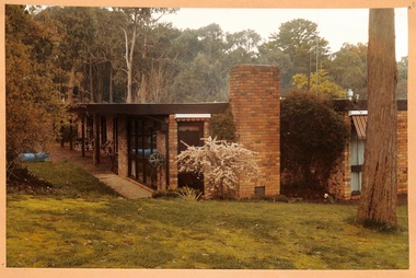 Buninyong & District Historical Society
Photograph - Original Photograph, Late C20th Mt. Helen home in bush setting, 1980's
socialColour photo, Late C20th Mt. Helen home in bush setting, 1980'sbrick house, late c20th, mt. helen -
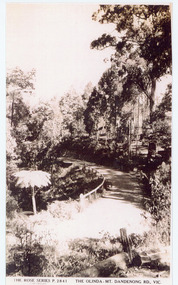 Mt Dandenong & District Historical Society Inc.
Photograph, The Olinda-Mt Dandenong Rd., Vic
Rose Series Postcard number 2841Copy of Rose Series postcard #2841 showing a stretch of the Olinda-Mt Dandenong Road.mount dandenong, mt dandenong road, rose series -
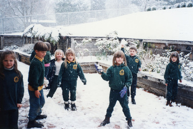 Mt Dandenong & District Historical Society Inc.
Photograph, Snow at Mt Dandenong Primary School 1995, 1995
Children playing in snow at the front of Mt Dandenong Primary School 5th September 1995.mt dandenong school, snow -
 Stawell Historical Society Inc
Map, Shire of Stawell, Quarry Site Mt Difficult Range, Standard Quarries Pty. Ltd, 1976
Shire of Stawell, Quarry Site Mt Difficult Range, Standard Quarries Pty. Ltd.stawell -
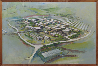 Federation University Art Collection
Painting - Artwork - Painting, Ballarat Institute of Advanced Education, Mt Helen Campus, c1970, c1970
This item is part of the Federation University Art Collection. The Art Collection features over 2000 works and was listed as a 'Ballarat Treasure' in 2007.Painting of the Ballarat Institute of Advanced Education (now Federation University) Mt Helen Campus.art, artwork, mt helen campus, federation university, ballarat institute of advanced education -
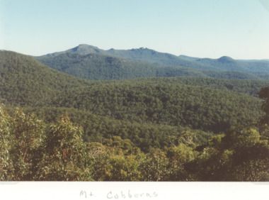 Lakes Entrance Historical Society
Photograph - Wombargo Saddle, Mt Cobberas Victoria, Bessie Larkin, 2/04/1994 12:00:00 AM
Colour photograph taken from Wombargo Saddle in the high country of Mt Cobberas Victoriatopography, mountains, forest -
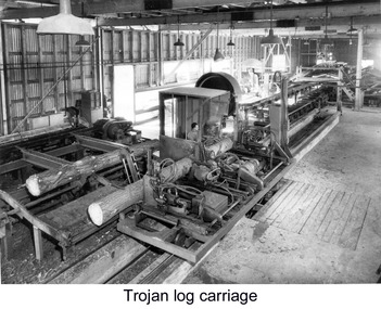 Glenelg Shire Council Cultural Collection
Photograph - Photograph - 'Trojan' Log Carriage with 'Sel-Set' and Feedworks at Dartmoor, n.d
Port of Portland Authority archives.Front: (no inscriptions) Back: "Trojan" Log Carriage with "Sel-Set" & Feedworks at Dartmoor (upper left, pencil). 19 (lower right, pencil). Photography by The Arthur Studio. Further copies always available at 27 Commercial St. East, Mt Gambier (lower right, purple stamp).port of portland archives -
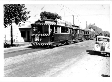 Ballarat Tramway Museum
Photograph - Digital image, Wal Jack, Tram 20 AETA tour Mt Pleasant, 21/04/1962
Photograph of the three trams at the Mt Pleasant terminus during an AETA tour 21-4-1962. No. 20 the service tram, 18 and 37 the tour trams. No. 20 has Advertisements for the SEC, Ilford Film and a dash panel advert for The Age newspaper. See image i2 for rear of photograph. See image i3 for hi res scan of print. See image i4 for hi res scan of negativeYields information about the trams used for an AETA visit in 1962 and worked within the service trams.Digital image from the Wal Jack Ballarat Album. On rear of photograph in ink "SEC, Ballarat AETA Special Tour, No. 20 Service car, Nos. 18 and 37 as specials, Mt Pleasant terminus 21-4-62" and Wal Jack stamp in top right hand corner with number "T1268" written in.trams, tramways, aeta, tours, special trams, mt pleasant, tram 20, tram 18, tram 37 -
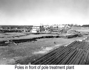 Glenelg Shire Council Cultural Collection
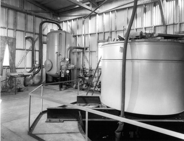
Photograph - Photograph - Dartmoor timber treatment plant and mill, n.d
Port of Portland Authority archives.Front: (no inscriptions) Back: Poles in the background. Timber treatment plant in middle. Mills at background. Photography by the Arthur Studio. Further copies always obtainable at 27 Commercial St. East, Mt. Gambier. (purple stamp, lower right) (upper left, pencil), 22 (lower right, pencil).port of portland archives -
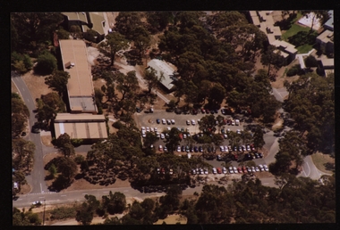 Federation University Historical Collection
Photograph - Colour, Aerial Photographs of the Federation University Mt Helen Campus
Seven colour photographs and a number of negative strips of the Mt Helen Campus, including student residences.mount helen, mount helen campus, federation university, student residences -
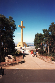 Whitehorse Historical Society Inc.
Photograph, Memorial Cross, Mt. Macedon
Coloured photo of Memorial Cross, Mt. Macedon. Original tiles from Wunderlich Tile Works.wunderlich limited -
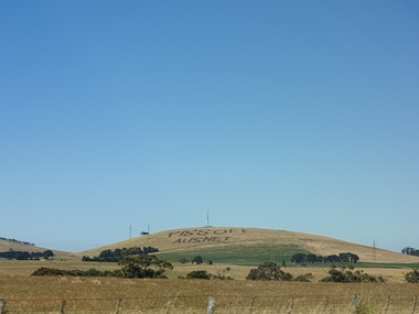 Ballarat Heritage Services
Plaque, Piss Off Ausnet, Mt Prospect
Angry farmers protest Angry farmers protest against huge power transmission land which will destroy pristine views and make some agricultural land unusable. A rural landscape at Mt Prospect on which has been plouhed the words 'Piss Off Ausnet"piss off ausnet, newlyn, mt prospect -
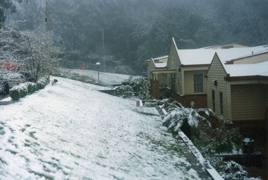 Mt Dandenong & District Historical Society Inc.
Photograph, Snow at Mt Dandenong Primary School 1995, 1995
Snow at Mt Dandenong Primary School 5th September 1995. Snow lasted 3 days.mt dandenong school, snow -
 Ballarat Heritage Services
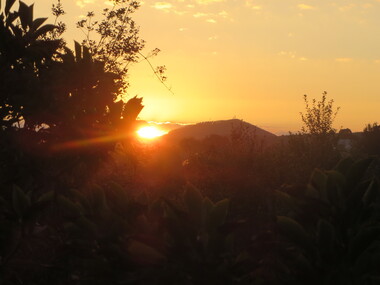
Photograph - Photograph - Colour, Sunrise towards Mt Warrenheip, Ballarat, 16/03/2016
Colour photograph of sunrise looking towards Mt Warrenheip from Armstrong Street South, Ballara.mount warrenheip, sunrise, ballarat -
 Buninyong & District Historical Society
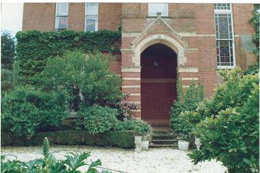
Photograph - Colour photograph, frint porch "Mt. Boninyong" homestead, Front porch, "Mt. Boninyong" homestead
historic, Scott family, settlement, buildingsColour photo, front porch "Mt. Boninyong" homestead, partly covered with ivy, lush garden.scott family, settlement, buildings -
 Mt Dandenong & District Historical Society Inc.
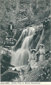
Photograph, Olinda Falls at Mt Dandenong, Early 1900s
Photograph from the Dower family collection taken of the Upper Olinda Falls in the early 1900s. The two men, two women and young boy are all well dressed and posing for a photograph.Black and white photograph received as a jpeg digital image 576KB showing two womwn, two men and a boy at the Olinda Falls early 1900s.On front of image: Early 1900s Olinda Falls at Mt Dandenongolinda falls, mt dandenong, mount dandenong, falls, upper olinda falls -
 Mt Dandenong & District Historical Society Inc.
Photograph, The Mt Dandenong Road c1930, c1930
Formed, unmade road. Possibly between Silvandale Store and FiveWays, Kalorama. Copy of Rose Series postcard # 310. (2 copies)Black and white photograph showing a road passing through trees. THE ROSE SERIES P. 310 THE MT DANDENONG ROAD VICfiveways, rose series, mt dandenong road -
 Linton and District Historical Society Inc
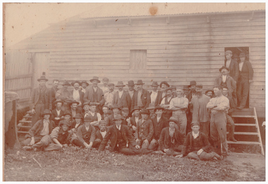
Photograph, Mt Bute Shearing Shed and Shearers
Sepia photograph of a large group of men dressed in working clothes, all wearing hats or caps, some standing behind others kneeling or seated on ground, with three men in suits and hats in the group posed in front of a large wooden building."Mrs Surman / H Kelly / Mt Bute shearing shed".mt bute shearing shed, shearers, rural activity, workers