Showing 32406 items
matching north-west-indies
-
 Eltham District Historical Society Inc
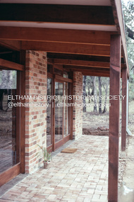
Photograph, Michael Wood, Front verandah, Wood family home post construction, 184 Progress Road, Eltham North, February 1970, 1970
Wood family home (1969-2011) pre and post construction by Knox and HellemonsKodachrome 35mm colour transparency in cardboard mount Processing date FEB70M6Inscribed in ink "Front verandah, 184 Progress Rd Eltham North 1970"alistair knox design, eltham north, hellemon, houses, progress road -
 Ringwood and District Historical Society
Photograph, North west shops in Melbourne Street, Ringwood in 2008, at the corner of Maroondah Highway. Showing the Activate Church and Burdines
Photographic record by Russ Haines, RDHS, in 2008. -
 Ringwood and District Historical Society
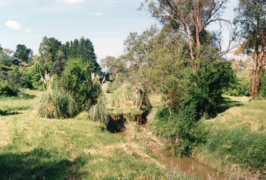
Photograph, Mullum Mullum Creek on 29th Oct 1989, north bank 100m west of Harrison Street, Unknown date
Digital photograph -
 Eltham District Historical Society Inc
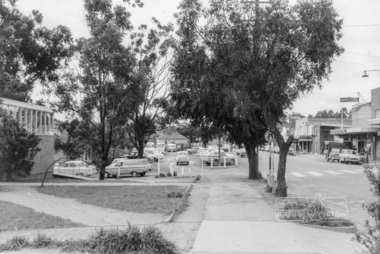
Photograph, Looking north along the west side of Main Road through the shopping centre, Eltham, February 1968, Feb 1968
Shows the pedestrian crossing to the Railway Station and car parking.In February 1968 an unknown person took a series of photos from the Eltham Hotel at Pitt Street heading north along Main Road through the shopping centre to just north of Elsa Court covering the length of the section of Main Road which was duplicated shortly thereafter. Shows the condition and environment of the streesscape of Main Road, Eltham immediately prior to the duplication between Pitt Street and Elsa Court through the shopping centre. Also shows a number of shops and businesses that operated at that time.Black and white photographduplication, eltham, main road, carparks, railway station, post office, shopping centre -
 Eltham District Historical Society Inc
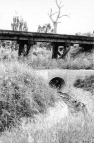
Photograph, Looking west from Main Road from just north of intersection with Diamond Street, Eltham, February 1968, Feb 1968
The watercourse passes under the road and railway at this point. Significant flash flooding occurred along this water course on Christmas Day 2011 causing significant damage to the railway line and road and flooding of Judge Book Village. The drain was swept away including the support pillars of the rail lines timber framework. Judge Book Village had some 40 units flooded before the water entered Diamond Creek. The water had flowed down and flooded Valonia Drive then Grove Street before flowing down the watercourse to Main RoadIn February 1968 an unknown person took a series of photos from the Eltham Hotel at Pitt Street heading north along Main Road through the shopping centre to just north of Elsa Court covering the length of the section of Main Road which was duplicated shortly thereafter. Shows the condition and environment of the streesscape of Main Road, Eltham immediately prior to the duplication between Pitt Street and Elsa Court through the shopping centre. Also shows a number of shops and businesses that operated at that time.Black and white photographduplication, eltham, main road, diamond street, watercourse, drainage, railway line -
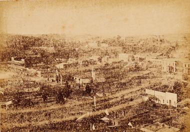 Bendigo Art Gallery
Photograph - Work on paper, Nicholas CAIRE, View From St. Paul's Church, Looking North West, 1875
Inscribed on original mountcard, l.l., gold letterpress, "N.J. CAIRE"bendigo, sandhurst, photograph, work on paper -
 Tatura Irrigation & Wartime Camps Museum
Booklet, Mooroopna North West (Ram Dam), 1978
A recording of history of early times to present day. Foreward by Martin Delaney. 3 copiesHistory of school and district settlement 1878-1978school centenary, ram dam, irrigation, schools, books, history, local -
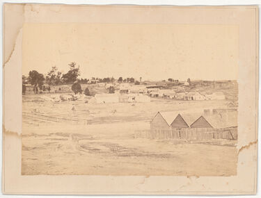 Castlemaine Art Museum
Photograph - Black and white print, Fryerstown, looking north west, taken from High Street on the road going down the hill at "breakneck"
-
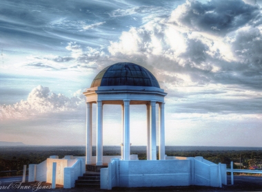 Stawell Historical Society Inc
Photograph, Pioneer Memorial on Big Hill looking North West -- Coloured
Pioneer Memorial looking Northwest with a spectacular sky background. The foundation stone of the memorial was laid in c 1935.Colour photograph of the magnificent Pioneers Memorial on Big Hill. View is looking toward the Northwest just showing the edge of the Grampians. Photo shows the memorial with a spectacular sky background.Carol Anne Jonesstawell -
Stawell Historical Society Inc
Photograph, Davis Open Cut West Wall North End
Photo of Stripping 1987mining, gold, panorama -
Whitehorse Historical Society Inc.
Article, Deputy Mayor returned to North-West ward, 1993
Re-election of Kevin Abbott to council; deputy mayor at the time, Noel Spurr nominated as deputy mayorRe-election of Kevin Abbott to council; deputy mayor at the time, Noel Spurr nominated as deputy mayorRe-election of Kevin Abbott to council; deputy mayor at the time, Noel Spurr nominated as deputy mayorabbott, kevin, spurr, noel, local government, mayors, councillors, city of nunawading -
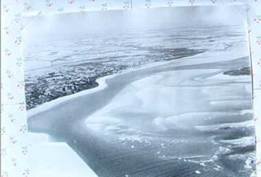
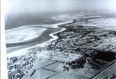 Inverloch Historical Society
001247 - Photograph - circa 1960's - Aerial Photograph - Inverloch from North East (looking South West) - from L Bailey
-
 Inverloch Historical Society
001249 - Photograph - Aeriel View of Inverloch from South West (Looking North East)
-
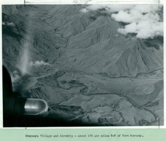 Department of Health and Human Services
Menyamya Village and airstrip about 175 aeronautical miles North West of Port Moresby. Papua New Guinea - Department of Health – National Fitness Office (Sports & Recreation) – Historical Press Release Photo Collection
Department of Health – National Fitness Office (Sports & Recreation) – Historical Press Release Photo - Empire Youth Day & Royals on Tour CollectionDepartment of Health – National Fitness Office (Sports & Recreation) – Historical Press Release Photo - Empire Youth Day & Royals on Tour Collection -
Moorabbin Air Museum
Book - THE NORTH-WEST AERIAL FRONTIER 1919-1934, EDWARD P. WIXTED, 1985
-
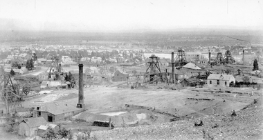 Stawell Historical Society Inc
Photograph, Panorama Of Stawell from Big Hill looking North West 1878 Mines Visible
On very left behind the winding engine shed in the foreground is the South Cross Mines No8 & No9. The next mine to the right not counting the Whims is the Crown Cross United Mine with curved tramway. Tyne Reefing Company is barely visible at centre of image in front of left end of settling dam. The Great Northern is centre right of image, Extended Cross Reef Mine, then Oriental Mine, the Grant Lamont Battery and two Pleasant Creek Cross Reef Poppet Heads.Scotchmans United Quarts Mining Company 1878Victorian Views. C. Herbert, Photo. Stawell 1878stawell mining -
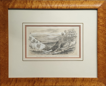 Federation University Art Collection
Work on paper - Lithograph, Ballarat in 1852.(Looking North West from Mt Buninyong), 1887
This item is part of the Federation University Art Collection. The Art Collection features over 2000 works and was listed as a 'Ballarat Treasure' in 2007.Framed chromo-lithograph depicting a landscape with deep slopes. The lithograph is from Withers 'History of Ballarat'.art, artwork, s.t. gill, samuel thomas gill, f.w. niven, buninyong, ballarat, landscape, available -
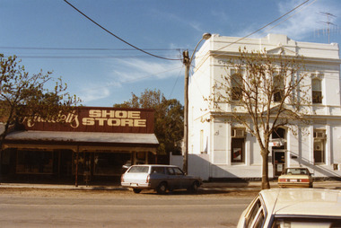 Charlton Golden Grains Museum Inc
Photograph, West end, north side of High St Charlton 1987, c.1987
Arundell's Shoe Store moved to current location from the centre of High St c.1986 . Formerly E. Stowe's fruit shop and cafe. Westpac Bank, formerly Commonwealth Bank of Australasia built 1887. Part of the Shire Council streetscape series 1987.Colour photograph showing Arundell's Shoe Store on the left and the two storey, white Westpac Bank on the right. Blue and white station wagon parked in front of Arundell's and a yellow car is parked in front of the Bank. A white car is in the lower RH corner of the photo.arundell, arundell's shoe store, westpac, westpac bank, e. stowe, charlton, business, industry -
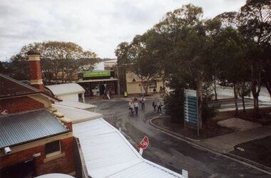 Ringwood and District Historical Society
Photograph, Ringwood Railway Precinct circa 2008, showing the shops on north-west corner, and station entrance
-
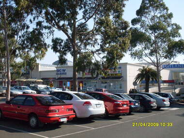 Ringwood and District Historical Society
Photograph, Looking across stage 4 Eastland carpark, towards the north-west, on 21 April 2009. Showing the car park entrance and front Eastland shops
Ron Brons photographic study of Ringwood. -
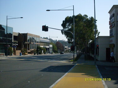 Ringwood and District Historical Society
Photograph, Ringwood Street looking north-west, Ringwood on 21 April 2009. Police Station on left
Ron Brons photographic study of Ringwood -
 Kew Historical Society Inc
Photograph, J F C Farquhar, Bird's Eye View Looking West, 1891
At the beginning of the 1890s, the Kew businessman and Town Councillor, Henry Kellett, commissioned J.F.C. Farquhar to photograph scenes of Kew. These scenes included panoramas as well as pastoral scenes. The resulting set of twelve photographs was assembled in an album, Kew Where We Live, from which customers could select images for purchase.The preamble to the album describes that the photographs used the ‘argentic bromide’ process, now more commonly known as the gelatine silver process. This form of dry plate photography allowed for the negatives to be kept for weeks before processing, hence its value in landscape photography. The resulting images were considered to be finely grained and everlasting. Evidence of the success of Henry Kellett’s venture can be seen today, in that some of the photographs are held in national collections.It is believed that the Kew Historical Society’s copy of the Kellett album is unique and that the photographs in the book were the first copies taken from the original plates. It is the first and most important series of images produced about Kew. The individual images have proved essential in identifying buildings and places of heritage value in the district.Before true aerial photography became possible, photographers such as J.F.C. Farquhar were compelled to shoot their images from the highest vantage point. Here, it is presumed to be the roof of Xavier College, from which the panoramic view extends west towards the rise of Studley Park. The houses in the foreground face the southern end of Gellibrand Street. Wellington Street is at an angle to the camera with the Queen Street intersection on the near right. The wooden building behind the large horse paddock on the other side of Gellibrand Street is the Kew Recreation Hall, built 1888, demolished 1960. It was reputed to have one of the finest dancing floors in or around Melbourne. The Bowling Green at the rear of the Hall belonged to the Kew Bowling Club. Further west is the Kew Railway Station on Denmark Street, opened to the public in 1887. At this period, much of Studley Park was locked up in large landholdings, dominated by large mansions such as ‘Byram’. Bird's Eye View Looking Westkew illustrated, kew where we live, photographic books, henry kellett, denmark street, kew recreation hall, kew bowling club, wellington street -
Stawell Historical Society Inc
Photograph - Framed Photographic Print, North Western woolen Mills, Graeme S Bennett, 1980
Boardroom Photograph Donated from Bennett Family North Western Woolen Mills. Later Norwellan then Aunde Large framed portrait of man in suitGraeme Bennett Managing Director North Textiles 1980 - 1996 manufacture -
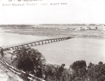 Lakes Entrance Historical Society
Photograph - Timber North Arm Bridge, North Arm bridge, Lakes Entrance Victoria, 1900 c
Black and white photograph of the timber bridge over North Arm showing Club Hotel and guest houses facing front lake Lakes Entrance VictoriaFirst Wooden Bridge over North Armbridges, engineering, gippsland lakes -
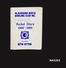 Whitehorse Historical Society Inc.
Book - Pocket Diary 1988-1989, Blackburn North B C
A small book Pocket Diary for 1988-1989 for the Blackburn North Bowling ClubBlackburn North Bowling Club Inc. Pocket Diary 1988-1989 Telephone 8786756 -
Whitehorse Historical Society Inc.
Pamphlet, Junction Road, Blackburn North, 1/05/1995
Auction of 'Harwood', 17-21 Junction Road, Blackburn North, 6/5/1995.auctions, harwood, junction road, blackburn north, nos. 17-21 -
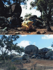 Stawell Historical Society Inc
Photograph, Sister Rocks looking West --2 Photos -- Coloured
Two colour photographs of Sister Rocks Stawell. Looking West. c 2011 Two colour photographs of Sister Rocks taken from the west c 2000 -
 Eltham District Historical Society Inc
Photograph, Michael Wood, Houses on Progress Road viewed from Glen Park Road, Eltham North, February 1970, 1970
Wood family home (1969-2011) pre and post construction by Knox and Hellemons Shows Wood family home on Progress Road in centre of field of viewKodachrome 35mm colour transparency in cardboard mount Processing date FEB70M6Inscribed in ink "Hoses on Progress Rd from Glen Park Rd, Eltham North 1970"alistair knox design, eltham north, hellemon, houses, progress road, glen park road -
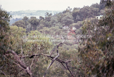 Eltham District Historical Society Inc
Photograph, Michael Wood, View south from 184 Progress Road to houses on Scenic Crescent, Eltham North, February 1970, 1970
Wood family home (1969-2011) pre and post construction by Knox and HellemonsKodachrome 35mm colour transparency in cardboard mount Processing date FEB70M6Inscribed in ink "View south from 184 Progress to Scenic Crescent, Eltham North 1970"alistair knox design, eltham north, hellemon, houses, progress road, scenic crescent -
 Kinglake Historical Society
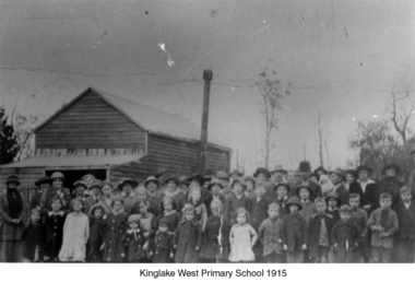
Kinglake West Primary School
Photograph of original Kinglake West Primary (State) School building with children and families. School built in 1896 by the pioneering families as Education Department would not build a school. Built on land selected by the Snell family.Only known photograph of the original school buildingPhotograph of original Kinglake West Primary School building education, school, pioneers, kinglake west