Showing 193 items matching "post war development"
-
 Glen Eira Historical Society
Photograph, Beauville Avenue, 17, Murrumbeena, 2001
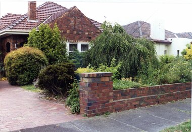
Originally labelled "Beauville Estate, Established 1936, Still Thriving 65 years on, 10th March 2001", the Beauville Estate Album contains colour photographs of houses in the Estate. They were taken around the time of the Beauville Estate’s 65th Heritage Celebration held on 10/03/2001 and donated to the Caulfield Historical Society shortly afterwards. Photographer Bev Baxter. City of Glen Eira’s Heritage Management Plan Vol 2 p79 (this is p84 of the pdf version) – HO12 Beauville Estate and environs, Murrumbeena: The Beauville Historic Area is important at the State level as the first large housing estate undertaken by the AV Jennings Construction Co, later Jennings Group Limited, Victoria’s largest home builder. It is important also as a very early estate development incorporating a range of features other than houses and including made roads, shops and recreation facilities. In this respect it was the forerunner of the comprehensively planned housing estate of the post war era. The estate is distinguished by its aesthetic values, as is the earlier and comparable Hillcrest Estate, which are formed by a combination of restrained diversity in house styles, with the exception of no. 30 in the emerging International style, and by a landscaped garden environment. Colour photograph of an unpainted brown brick house with decorative brickwork. Other features include a porch with 2 arched entrances, tiled roof and low unpainted brick fence in the foreground with "17" on the brick pillar beside the driveway.murrumbeena, houses, beauville avenue, architectural styles, 1930's, inter war style, a.v. jennings, av jennings, jennings, brick houses, beauville estate, porches, arches, sir albert victor jennings, a v jennings construction co, beauville estate heritage area, glen eira city council, architectural features, plans, jennings group limited, land subdivision, gardens, beauville historic area, brick features, brick fences -
 Kew Historical Society Inc
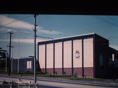
Photograph - Kew City Hall, Ron Setford, 1960
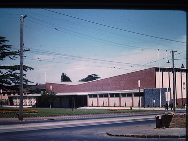
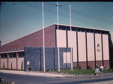
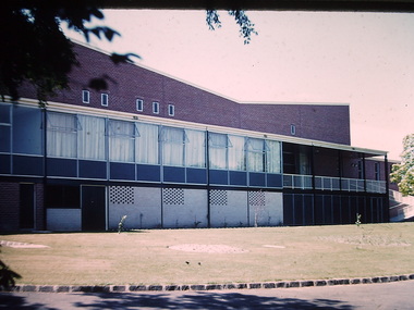
Ron Setford and his wife Grace Setford lived in Tanner Avenue, East Kew, from c.1946 to c.1995. A keen photographer, he recorded the changing face of Kew over a 20 year period. Apart from 30 photographs of built structures and places in Kew dating from 1960 and 1961, 145 of his 35mm colour slides chronicle the development of the Eastern Freeway through the Yarra Valley over a five year period from c.1972 to c.1977. This important collection was donated to the Society by his granddaughter in 2025.This collection of 175 35mm slides is of local and statewide significance, owing to its subject matter, particularly the major development of road transport infrastructure during the 1970s with the construction of the Eastern Freeway. The photographer also took care to annotate and date most of his slides which enable the researcher to pinpoint temporal and spatial locations.The Kew City Hall in Cotham Road, designed by Harold Bartlett, was intended as the initial phase in a scheme to develop an entire civic precinct. This was representative of a widely-held belief, of the immediate post-war era, that a district's civic centre should be precisely that – not just a single grand building for official use, but a dedicated precinct providing a range of community facilities as well as an administrative function. The Kew masterplan was later abandoned. The City Hall was designed to cater for public or official functions. Its interior had a small stage at one end for intimate theatrical productions, a larger stage at the other (with sunken orchestra pit) for musical performances, plus the most up-to-date equipment for live TV transmission."Kew Town Hall"ron setford, photographs -- kew (vic.) -- 1960s, kew town hall -
 Kew Historical Society Inc
Photograph - Country Roads Board and Denmark Street Baby Health Centre, Ron Setford, 1961
Ron Setford and his wife Grace Setford lived in Tanner Avenue, East Kew, from c.1946 to c.1995. A keen photographer, he recorded the changing face of Kew over a 20 year period. Apart from 30 photographs of built structures and places in Kew dating from 1960 and 1961, 145 of his 35mm colour slides chronicle the development of the Eastern Freeway through the Yarra Valley over a five year period from c.1972 to c.1977. This important collection was donated to the Society by his granddaughter in 2025.This collection of 175 35mm slides is of local and statewide significance, owing to its subject matter, particularly the major development of road transport infrastructure during the 1970s with the construction of the Eastern Freeway. The photographer also took care to annotate and date most of his slides which enable the researcher to pinpoint temporal and spatial locations.A photograph providing a visual contrast of the pre and post-World War II architectural styles of the Denmark Street Baby Health Centre and two of the Country Roads Board office buildings. Each was built on part of the land fronting the Kew branch line. In May 1939, the Railway Commissioners agreed to lease a site at the Kew Railway Station for a Baby Health Centre. The single-storey cream brick building was designed by Roland Chipperfield. The Country Roads Board (1913–83), later renamed VicRoads, transferred its headquarters from the Royal Exhibition Building to Kew in 1961, following the completion of two modernist eight-storey office towers in 1960. The VicRoads buildings were closed in 2024, and there is ongoing debate about what replaces them.Nilron setford, photographs -- kew (vic.) -- 1960s, country roads board, vicroads, denmark street -- kew (vic.), denmark street baby health centre -
 Kew Historical Society Inc
Photograph - Kew City Hall, Ron Setford, 1960
Ron Setford and his wife Grace Setford lived in Tanner Avenue, East Kew, from c.1946 to c.1995. A keen photographer, he recorded the changing face of Kew over a 20 year period. Apart from 30 photographs of built structures and places in Kew dating from 1960 and 1961, 145 of his 35mm colour slides chronicle the development of the Eastern Freeway through the Yarra Valley over a five year period from c.1972 to c.1977. This important collection was donated to the Society by his granddaughter in 2025.This collection of 175 35mm slides is of local and statewide significance, owing to its subject matter, particularly the major development of road transport infrastructure during the 1970s with the construction of the Eastern Freeway. The photographer also took care to annotate and date most of his slides which enable the researcher to pinpoint temporal and spatial locations.The Kew City Hall in Cotham Road, designed by Harold Bartlett, was intended as the initial phase in a scheme to develop an entire civic precinct. This was representative of a widely-held belief, of the immediate post-war era, that a district's civic centre should be precisely that – not just a single grand building for official use, but a dedicated precinct providing a range of community facilities as well as an administrative function. The Kew masterplan was later abandoned. The City Hall was designed to cater for public or official functions. Its interior had a small stage at one end for intimate theatrical productions, a larger stage at the other (with sunken orchestra pit) for musical performances, plus the most up-to-date equipment for live TV transmission.Nilron setford, photographs -- kew (vic.) -- 1960s, kew town hall -
 Bendigo Historical Society Inc.
Document - LONG GULLY HISTORY GROUP COLLECTION: HISTORICAL GUIDE TO BENDIGO
Brochure with an invitation to visit Historical and Mining Museum in Mechanic's Institute, Eaglehawk. Drawing of poppet legs on the front with The Royal Historical Society of Victoria Bendigo Branch. Historical Guide to Bendigo including Self Tours of Bendigo's Famous Goldfields. Forward by John Hattam. Contributors are: H Biggs, Miss L J Parry, A Richardson, L C Bennetts and Edith Checcucci. Credits - The Bendigo Advertiser, Cambridge Press, Mines Department (Bendigo) and J R W Purves. Items include Bendigo Tramways Compiled by H Biggs, Early Bendigo Hotels Compiled by L C Bennetts, Eaglehawk Compiled by H Biggs, Noted Events Compiled by June Parry, The Bendigo Post Office Compiled by LC Bennetts, The Bendigo Goldfield. Introduction to Field and Guide to Some Famous Mines Compiled by A Richardson. Photos include: Pall Mall Bendigo, Ravenswood Homestead, An Early Battery at Kangaroo Flat, Historic High Street Golden Square, The Lonely Grave, Battery Tram c1888, Steam Tram c1892, Electric Tram c1903, The New Chum Railway Golden Square, United Hustlers and Redan Mine Sandhurst Road, Central Deborah Violet Street, Deborah Mine Quarry Hill, Deborah Mine 1000 ft level, First Motion Winding Engine at Central Deborah, Victoria Hill Area, and Looking south from New Chum Hill in 1890's. Also 11010.254, 255, 268, 288a, 288b, and 289.bendigo, history, long gully history group, the long gully history group - historical guide to bendigo, the royal historical society of victoria bendigo branch, historical and mining museum, mechanic's institute eaglehawk, librarian mechanic's institute, miss j parry, john hattam, h biggs, a richardson, l c bennetts, edith checcucci, bendigo advertiser, cambridge press, mines department (bendigo), j r w purves, mr a o'keefe, shire of marong, the sandhurst and eaglehawk tramway company, mr j taylor, mr j hanson, the bendigo tramway company, electric supply company, coliban water suply, juvenile industrial exhibition, geo lansell, cr a harkness, salvation army, vine and fruitgrowers association, decentralisation league, constable thomas ryan, miners association, art gallery, post office, miss broadfoot, bendigo hospital, opera company, bendigo development league, victorian women's franchise league, ana hall, the bendigonian, law courts, temperance hall, trades hall (old wardens court), roman catholic cathedral, shamrock hotel, bendigo philosophical society, old bendigonian society, bendigo fire brigade, bendigo volunteers to south african war, hawkins, porcupine inn, criterion hotel, royal hotel, bendigo hotel, black swan hotel, gillies bakery, hibernian hotel, sandhurst hotel, freemasons hotel, courthouse hotel, shamrock hotel, governor hotham, heffernan & crowley, new chum railway, victoria quartz, shenandoah, shamrock mine, hercules no 1 (originally pearl east), hercules new chum (late pearl), carlisle mine, mr arblaster, meurer, sandhurst bee, benevolent asylum, bendigo gas company, a lloyd, coliban water supply scheme, cr w v simons, eaglehawk council, j mouat, sir henry barkly, agricultural and horticultural exhibition, sandhurst and eaglehawk boroughs, cr john mcintyre, latham and watson's mine, galatea (model ship), st paul's church of england, rev g p despard, fine arts exhibition and exposition, bendigo rifle association, strathfieldsaye shire hall, corporate high school, bendigonian society, richard andrews, easter fair, g aspinall, j burnsides, sir h manners sutton, beehive stores, mining exchanges, bendigo water works, city family hotel, bendigo united friendly society medical institute and dispensary, benevolent asylum, jewish synagogue, masonic hall, school of mines, mr j h abbott, australian natives association, royal princess theatre, albion hall, central state school, high school, gravel hill state school, electricity commission, james mouat, warring natives, the rocks, joseph crook, gold discovery, marong district roads board, camp hotel, mr charles sherratt, city of bendigo, mt alexander north run, grice and heape, ravenswood, gibson and fenton, mrs john kennedy, mrs patrick farrel, mr j a paton, mr lachlan mclachlan, theatre royal, sir charles and lady hotham, harney's bridge, e j ennor, sandhurst fire brigade, the health of towns act, mr townsend, cornish & co, bendigo pottery, bendigo agricultural society, pike or pyke, baby health centre, sandhurst post office, government survey office, sandhurst trustees company, mr h b briston, savings bank, telegraph office, sir henry brougham lock, hon sir john nimmo, sandhurst public offices, the new prince of wales mine, new prince of wales no 2, the whip and jersey, lansell's big 180, new chum and victoria mine and battery, new chum railway, koch's pioneer, south new moon, catherine reef united, new moon, virginia mine, south belle vue, new chum railway, central nell gwynne, north nell gwynne, ironbark mine, new chum syncline, hercules, herculesl energetic, roberts & sons, harkness & co, horwoods, great southern, ulster, carlisle, cornish, new st mungo, duchess tribute, south devonshire, hopewell mine, saxby mine, mcnair & co, mr king, bourke and wills, sandhurst hotel, the dascombe nugget, victoria nugget, r r haverfield, ballerstedt, rae, wittscheibe, lazarus, cave and amos, bendigo amalgamated goldfields, bendigo mines limited, the deborah, north deborah, central deborah, the new red white and blue consolidated (big blue), union, lansell's new red white and blue 9later no 3 shaft), h harkness & co, thompson & co, central deborah, lansell's bendigo battery, north red white and blue, central red white and blue, roberts and sons, little 180 (originally lansell's 180 no 2 shaft), john brown knitwear factory, south ironbark originally victoria consols east shaft, ironbark (originally ironbark east shaft), manchester arms hotel, wattle gully mine chewton, hercules, old wheal-owl, central nell gwynne, gold mines hotel, bendigo city council, jack barker, the new chum syncline, the courier of the mines, telegraph office, bendigo cemetery, white hills cemetery, eaglehawk cemetery, kangaroo flat cemetery, new moon, suffolk united, north new moon, fortuna hustlers, buckell & jeffrey's, royal hustlers reserve no 2 (city and park shafts), jonathan harris, latham and watson, great hustlers, great extended hustlers, j hustler, latham, watson, tribute or pups shaft, bendigo's worst mining disaster, hustlers reef (old hustlers), hustlers reef no 1, lansell's comet, the old comet (cooper's claim), united hustlers and redan, comet hill state school, k k shaft, north or new hustlers (agnew hustler), johnson's no 3, south johnson's, lansell's sandhurst needle, cleopatra needle top, british american, collman and tacchi, south virginia, saddle reefs and spurs, pall mall bendigo, ravenswood homestead, an early battery at kangaroo flat, historic high street golden square, the lonely grave, battery tram c1888, steam tram c1892, electric tram c1903, teh new chum railway golden square, united hustlers and redan mine sandhurst road, central deborah violet street, deborah mine quarry hill, deborah mine 1000 ft level, first motion winding engine at central deborah, victoria hill area, looking south from new chum hill in 1890's -
 Eltham District Historical Society Inc
Document - Property Binder, 616 Main Road, Eltham; Plum Cottage
Plum Cottage is covered by Heritage Overelay HO256 in the Nillumbuk Planning Scheme This two-lot land holding was created as a subdivision and sold to Charles Stuart McNeil by May 1955. Sometime in the period 1955-1960, the builder-designer, John Harcourt had created a pise house on the site, straddling the two subdivision lots. The designer, John M. Harcourt was a pioneer builder in pise-de-terre and mudbrick in the Eltham Shire, Eltham being synonymous with alternative lifestyles and building practises until the onset of suburbia in the late 20th and early 21st centuries. This hipped-roof house is set high above Main Road on a V-shape plan characteristic of the Arts & Crafts style, with rammed earth or pise walls, timber joinery and a cement tiled roof. The V shape plan was used by important English and Eltham Arts & Crafts designers. The use of natural materials such as stone and timber construction is an essential part of the Arts & Crafts style and Harcourt’s work. So too is the application of the style on both the exterior and interior of the house as a holistic concept. The house adjoins the Lim Joon adobe house built and designed by Alistair Knox in the same era (HO119), thus forming a distinctive pair, both using an uncommon plan form. This house was identified in the Shire of Shire of Eltham Heritage 1992 as contributory to the Eltham Gateway Conservation Area, then proposed as an urban conservation area (now Heritage Overlay Area). Land Ownership Emily Jane Smith of 12 Woodside Street Fitzroy owned Crown Allotments 1 & 2 Sections 14, 27 by August 1918, selling to William Henry Smith of 12 Woodside Street, Nth Fitzroy May 1921. (John) James Isherwood of Main Road, Eltham owned the property by 1928 (the year of his death) with the beneficiary of his estate and next owner of this site being his widow, Minnie Maria Isherwood of Cemetery Road, Eltham. His holding in Main Road included parts of what was described in rate records as allotments1 & 2 Section E6. In the late 1930s, early 1940s her son Alfred John Isherwood was also rated for the land around this site, with the rated nett annual value varying between £2 and £5. Alfred Isherwood also lived at Main Road, Eltham with his wife Ellen: her early death at the age of 24 was reported in the Argus of 1923. Part of the Isherwood land was divided off and sold to Charles Stuart McNeil by May1955. Sometime in the period 1955-1960, the builder-designer, John Harcourt had created a pise house on the site, straddling the two subdivision lots. The house is visible on an aerial photograph from 1960s. Reputedly the house was called Plum Cottage and erected for Harcourt’s mother-in-law. A garage was added in 1959. Charles McNeil died in1971 aged 87: he was the son of Don McNeil and Margaret Arkell. Available rate records from the construction era start in the of the 1970s (1972-3) and list Mr H.C. & M/S A.V. Charity at 616 Main Road Eltham of this property with a nett annual value of $740. More recent valuer's data describes the property as lots 1 & 2 LP25668, located in the Central Riding of Eltham Shire, owned by Ann Valerie Charity and later, in 1990, by the Chincarini family. Building Description This hipped roof 11 .5 square house is set high above Main Road on a characteristic-shape plan and has rammed earth or pise walls, timber joinery and a cement tiled roof. The V-shape plan was used by Important designers such as C.F.A. Voysey (UK) who interpreted medieval domestic architecture as part of the Arts & Crafts style of the late 19th and early 20th centuries. The pise walls are covered with a textured render while the cement roofing tiles are also seen in the Harcourt Hill examples. Reputedly the ceiling joists are of a deep section and span long lengths with no need for hanging beams in the roof space. The ceilings are low and panelled in main rooms with apparently Caneite soft board infill panels between the exposed ceiling beams. These are painted white but may have been stained at one time. The focus of the house is the large living area with its vast random stone fireplace. Significance Plum Cottage is significant to the locality of Eltham because: Historically: • Plum Cottage is closely associated with the important historical theme of earth construction evident in Eltham and elsewhere in the Shire since theear1y Arts & Crafts inspired creations at Penleigh Boyd's The Robins (1912, HO101) and those at Montsalvat (1934-, HO82) but more prominent from the Second War period when earth building in Eltham was promoted in national periodicals as an alternative building method that avoided the building materials shortages of that era; • The choice of the earth building technique also expresses the theme of refuge or alternative living, synonymous with Eltham in the early to mid 20th century; • as a good example of domestic architecture from John Harcourt who was the first major post Second War figure in an important phase of Eltham’s earth building development, using his characteristic Old English or Arts& Crafts style that relies in this case on the pise wall construction, pitched roof forms, exposed ceiling joists, half timbering, random stonework, and panelled internal wall finishes. Architecturally: • Plum Cottage's pise wall construction is uncommon among the early earth-walled structures in the Shire, that are mainly of adobe or mud brick, and as a building material is uncommon among the Shire’s suburban dwellings generally which are clad typically with either fired clay bricks or timber boarding. Aesthetically: • Plum Cottage is a good and well preserved example of a modern Old English or Arts & Crafts style earth-walled building in the Shire • For the proximity of the significant Lim Joon adobe house designed by Alistair Knox adjoining to the north, providing a distinctive earth wall house pair, with uncommon plan forms. Reference Heritage Assessment of Plum Cottage, 616 Main Road, Eltham; Graeme Butler & Associates 2010main road, eltham, property, houses, (john) james isherwood, alfred john isherwood, ann valerie charity, arts and crafts style, charles stuart mcneil, chincarini family, eltham gateway zone, emily jane smith, h.c. charity, heritage assessment, john harcourt, john m. harcourt, lim joon house, main road eltham, minnie maria isherwood, pise construction, plum cottage -
 Kew Historical Society Inc
Photograph - Kew City Hall, Ron Setford
Ron Setford and his wife Grace Setford lived in Tanner Avenue, East Kew, from c.1946 to c.1995. A keen photographer, he recorded the changing face of Kew over a 20 year period. Apart from 30 photographs of built structures and places in Kew dating from 1960 and 1961, 145 of his 35mm colour slides chronicle the development of the Eastern Freeway through the Yarra Valley over a five year period from c.1972 to c.1977. This important collection was donated to the Society by his granddaughter in 2025.This collection of 175 35mm slides is of local and statewide significance, owing to its subject matter, particularly the major development of road transport infrastructure during the 1970s with the construction of the Eastern Freeway. The photographer also took care to annotate and date most of his slides which enable the researcher to pinpoint temporal and spatial locations.The Kew City Hall in Cotham Road, designed by Harold Bartlett, was intended as the initial phase in a scheme to develop an entire civic precinct. This was representative of a widely-held belief, of the immediate post-war era, that a district's civic centre should be precisely that – not just a single grand building for official use, but a dedicated precinct providing a range of community facilities as well as an administrative function. The Kew masterplan was later abandoned. The City Hall was designed to cater for public or official functions. Its interior had a small stage at one end for intimate theatrical productions, a larger stage at the other (with sunken orchestra pit) for musical performances, plus the most up-to-date equipment for live TV transmission.Nilron setford, photographs -- kew (vic.) -- 1960s -
 Narre Warren and District Family History Group
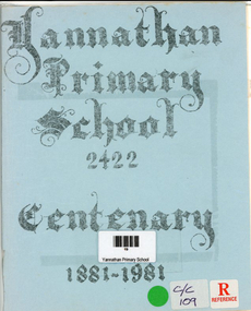
Book, Debra A Crowley, Yannathan Primary School 2422- Centenary 1881 - 1981, 1981
An account of the early history of Yannathan and the development of Yannathan School No. 2422. Lists original selectors, teachers, first committee members of the Yannathan Recreation Reserve and the Yannathan Hall. Also lists Yannathan's fallen war heroes.36 p.; 21 cmnon-fictionAn account of the early history of Yannathan and the development of Yannathan School No. 2422. Lists original selectors, teachers, first committee members of the Yannathan Recreation Reserve and the Yannathan Hall. Also lists Yannathan's fallen war heroes.yannathan (vic.), yannathan primary school no. 2422, yannathan (vic.) -- history -
 Broadmeadows Historical Society & Museum
Book - Souvenir Book, Jacana Primary School, Jacana Primary School No. 4839 Silver Anniversary 1960 to 1985, 1985
History of the Jacana Primary School between the years 1960 to 1985.A5 Book 12 pages with card cover (white).non-fictionHistory of the Jacana Primary School between the years 1960 to 1985.jacana, education, jacana primary school, silver anniversary, 1960 -
Broadmeadows Historical Society & Museum
Book - Community History, Elaine V Brogan OAM, Fifty years 1969-2019: History of the Western Metropolitan group of Historical Societies, 2019
Fifty Years of the WMGHS, from 196948-page white book with stapled card coversnon-fictionFifty Years of the WMGHS, from 1969western metropolitan group of historical societies, 1969, 2019, elaine v. brogan oam -
 Returned Nurses RSL Sub-branch
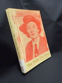
Book, Elizabeth Burchill, The paths I've trod, 1981
... and remained in this important post of increasing development in post ...'Dora Elizabeth Burchill was born in Hawthorn, Victoria and trained as a triple certificate nurse in Melbourne and London. Proving that nursing is the best passport for travel she subsequently travelled widely and became registered as a nurse in seven countries of the world. Cherishing the ideals of Florence Nightingale in peace and war, Sister Burchill volunteered to serve in Ethiopia during the Italian-Abyssinian War in 1936, nursed refugee children during the Spanish Civil War in 1937 and served with the 2nd AIF in Palestine and Egypt in 1940. Following six years as a member of the Australian Army Nursing Service, she took another challenging path, becoming involved in radio broadcasting [Working for 3SR Radio Station, Shepparton p185], writing and lecturing for the Commonwealth Institute in England. Six years later she returned to nursing and started the first full-time infant welfare clinic in Darwin for the Northern Territory Department of Health and remained in this important post of increasing development in post-war Darwin for five years. Sister Burchill continued this work in Thursday Island and the Sepik District of New Guinea into the 1960s. Many published articles in magazines and newspapers and five published books testify to her skill and determination as a factual writer. ?Innamincka?, is her best-known book. Seeking further worthwhile challenges in the 1970s, Sister Burchill studied for the Higher School Certificate which resulted in her earning a place in the Faculty of Arts, Monash University. She graduated as Bachelor of Arts in 1981. In 1986, she graduated as Bachelor of Letters at the University of Melbourne. Includes index. Bibliography: p. [249]-250. Medicine. Nursing. Burchill, Elizabeth, 1908-. Australia. Biographies (ANB/PRECIS SIN 0516392). Includes bibliographical references (pages 249-250) and index.' From TroveBook with green text on cover and spine and red image on coverfiction'Dora Elizabeth Burchill was born in Hawthorn, Victoria and trained as a triple certificate nurse in Melbourne and London. Proving that nursing is the best passport for travel she subsequently travelled widely and became registered as a nurse in seven countries of the world. Cherishing the ideals of Florence Nightingale in peace and war, Sister Burchill volunteered to serve in Ethiopia during the Italian-Abyssinian War in 1936, nursed refugee children during the Spanish Civil War in 1937 and served with the 2nd AIF in Palestine and Egypt in 1940. Following six years as a member of the Australian Army Nursing Service, she took another challenging path, becoming involved in radio broadcasting [Working for 3SR Radio Station, Shepparton p185], writing and lecturing for the Commonwealth Institute in England. Six years later she returned to nursing and started the first full-time infant welfare clinic in Darwin for the Northern Territory Department of Health and remained in this important post of increasing development in post-war Darwin for five years. Sister Burchill continued this work in Thursday Island and the Sepik District of New Guinea into the 1960s. Many published articles in magazines and newspapers and five published books testify to her skill and determination as a factual writer. ?Innamincka?, is her best-known book. Seeking further worthwhile challenges in the 1970s, Sister Burchill studied for the Higher School Certificate which resulted in her earning a place in the Faculty of Arts, Monash University. She graduated as Bachelor of Arts in 1981. In 1986, she graduated as Bachelor of Letters at the University of Melbourne. Includes index. Bibliography: p. [249]-250. Medicine. Nursing. Burchill, Elizabeth, 1908-. Australia. Biographies (ANB/PRECIS SIN 0516392). Includes bibliographical references (pages 249-250) and index.' From Trovenursing in warfare, elizabeth burchill, world war two, wwii, ww2, china-ethiopian war, spanish civil war, australian army nursing service -
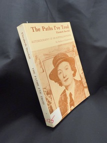 Returned Nurses RSL Sub-branch
Book, Elizabeth Burchill, The paths I've trod, 1981
... and remained in this important post of increasing development in post ...'Dora Elizabeth Burchill was born in Hawthorn, Victoria and trained as a triple certificate nurse in Melbourne and London. Proving that nursing is the best passport for travel she subsequently travelled widely and became registered as a nurse in seven countries of the world. Cherishing the ideals of Florence Nightingale in peace and war, Sister Burchill volunteered to serve in Ethiopia during the Italian-Abyssinian War in 1936, nursed refugee children during the Spanish Civil War in 1937 and served with the 2nd AIF in Palestine and Egypt in 1940. Following six years as a member of the Australian Army Nursing Service, she took another challenging path, becoming involved in radio broadcasting [Working for 3SR Radio Station, Shepparton p185], writing and lecturing for the Commonwealth Institute in England. Six years later she returned to nursing and started the first full-time infant welfare clinic in Darwin for the Northern Territory Department of Health and remained in this important post of increasing development in post-war Darwin for five years. Sister Burchill continued this work in Thursday Island and the Sepik District of New Guinea into the 1960s. Many published articles in magazines and newspapers and five published books testify to her skill and determination as a factual writer. ?Innamincka?, is her best-known book. Seeking further worthwhile challenges in the 1970s, Sister Burchill studied for the Higher School Certificate which resulted in her earning a place in the Faculty of Arts, Monash University. She graduated as Bachelor of Arts in 1981. In 1986, she graduated as Bachelor of Letters at the University of Melbourne. Includes index. Bibliography: p. [249]-250. Medicine. Nursing. Burchill, Elizabeth, 1908-. Australia. Biographies (ANB/PRECIS SIN 0516392). Includes bibliographical references (pages 249-250) and index.' From TroveBook with brown text on cover and spine and brown image on coverfiction'Dora Elizabeth Burchill was born in Hawthorn, Victoria and trained as a triple certificate nurse in Melbourne and London. Proving that nursing is the best passport for travel she subsequently travelled widely and became registered as a nurse in seven countries of the world. Cherishing the ideals of Florence Nightingale in peace and war, Sister Burchill volunteered to serve in Ethiopia during the Italian-Abyssinian War in 1936, nursed refugee children during the Spanish Civil War in 1937 and served with the 2nd AIF in Palestine and Egypt in 1940. Following six years as a member of the Australian Army Nursing Service, she took another challenging path, becoming involved in radio broadcasting [Working for 3SR Radio Station, Shepparton p185], writing and lecturing for the Commonwealth Institute in England. Six years later she returned to nursing and started the first full-time infant welfare clinic in Darwin for the Northern Territory Department of Health and remained in this important post of increasing development in post-war Darwin for five years. Sister Burchill continued this work in Thursday Island and the Sepik District of New Guinea into the 1960s. Many published articles in magazines and newspapers and five published books testify to her skill and determination as a factual writer. ?Innamincka?, is her best-known book. Seeking further worthwhile challenges in the 1970s, Sister Burchill studied for the Higher School Certificate which resulted in her earning a place in the Faculty of Arts, Monash University. She graduated as Bachelor of Arts in 1981. In 1986, she graduated as Bachelor of Letters at the University of Melbourne. Includes index. Bibliography: p. [249]-250. Medicine. Nursing. Burchill, Elizabeth, 1908-. Australia. Biographies (ANB/PRECIS SIN 0516392). Includes bibliographical references (pages 249-250) and index.' From Trovenursing in warfare, elizabeth burchill, world war two, wwii, ww2, china-ethiopian war, spanish civil war, australian army nursing service