Showing 331 items
matching route 11
-
 Ballarat Tramway Museum
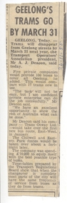
Newspaper, The Courier Ballarat, "Geelong's trams go by March 31", 26/11/1955 12:00:00 AM
Newspaper clipping from the Ballarat Courier? - 26-11-1955, titled "Geelong's trams go by March 31", replacing Geelong's 17 trams by 100 buses using five private companies. Quotes Mr A. J. Decon, Transport Operators Association President, and of Trans Otway Ltd. - about the take over of the first route in Jan. East-West. Contained originally within Reg Item 5623 at the front of this note book. For items see btm5623 loose items list.pdf.has date "26-11-55" in ink on right hand side at top.geelong, buses, closure -
 Ballarat Tramway Museum
Slide - 35mm slide/s - set of 11, Eldon Hogan, mid 1960's to early 1970's
Set of 11 Agfa Plastic mounted slides - from the Eldon Hogan collection - featuring an ARE tour with Nos. 21, 29 and 25 to Bendigo, mid 1960's. Scanned on the Canon scanner at the depot 15/12/1971 at the time of the installation of the scanner. .1 - four trams at Charing Cross - includes 19 and 25. .2 - 21 and 25 at the depot junction. .3 - 21 and 29 Quarry Hill route? .4 - 29 ditto .5 - 24 at Golden Square terminus - photo taken from the city side - note all the little shops and buildings on the left hand side of the photograph. .6 - 29, 21 and 25 at Eaglehawk .7 - 29 - side on view - Eaglehawk line? .8 - ditto with 21 .9 - 29 - North Bendigo line? - side on view .10 - 29 and 21 - vacant paddocks - Eaglehawk line .11 - 29 crossing the railway overbridge, Eaglehawk line, in bound. Trams have SEC roof advertisements. tramways, trams, bendigo, eaglehawk, charing cross, golden square, tram 21, tram 29, tram 25, tram 19 -
 Ballarat Tramway Museum
Photograph - Digital image, 1970s
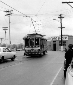
Yields information about the Mt Pleasant route and Barkly St.Digital image, black and white, of No. 11 in bound in Barkly St Mount Pleasant about to turn into Main St. Tram has a Twin Lakes Sign. Photo taken by Peter Bruce 1970's and 1971, prior to the closure of the Ballarat tramway system. Peter's Title of image: "No. 11 Barkly St"trams, tramways, barkly st, mt pleasant, tram 11 -
 Ballarat Tramway Museum
Photograph - Digital image, Peter Bruce, "No. 11 Mt Pleasant", 1970s
Yields information about the Mt Pleasant route and Barkly St.Digital image, black and white, of No. 11 in Barkly St, out bound to Mt Pleasant. Tram has a Twin Lakes sign. Photo taken by Peter Bruce 1970's and 1971, prior to the closure of the Ballarat tramway system. Peter's Title of image: "No. 11 Mt Pleasant" trams, tramways, barkly st, mt pleasant, tram 11 -
 Ballarat Tramway Museum
Photograph - Digital image, Peter Bruce, "No. 11 Setting down.", 1970s
Yields information about the Mt Pleasant route and Barkly St.Digital image, black and white, of No. 11 in Barkly St, out bound to Mt Pleasant setting down passengers. Tram has a Twin Lakes sign. Mini Minor motor car in the front of the tramcar. Photo taken by Peter Bruce 1970's and 1971, prior to the closure of the Ballarat tramway system. Peter's Title of image: "No. 11 Setting down."trams, tramways, barkly st, mt pleasant, tram 11 -
 Ballarat Tramway Museum
Photograph - Digital image, 1970s
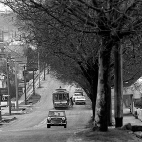
Yields information about the Mt Pleasant route and Main St.Digital image, black and white, of No. 11 in Main St Ballarat, running out to Mt Pleasant. Tram has a Twin Lakes sign. Robson Glaziers shop in the background. Photo taken by Peter Bruce 1970's and 1971, prior to the closure of the Ballarat tramway system. Peter's Title of image: "No. 11 turns out of Barkly St" (not correct location)trams, tramways, mt pleasant, main st, tram 11 -
 Bendigo Historical Society Inc.
Document - R.S.L. BENDIGO COLLECTION: TIME TABLE FOR MARCH
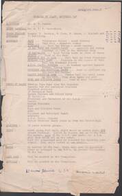
Typed time table for march. Detailed is the Assembly, Order of March, Spacings, Route, Bands, Last Post, Reveille, Traffic arrangements, and Timings. Written at the end of the first page is:'Dawn Service 6.30 ? ?.event, official, anzac day, r.s.l. bendigo collection - time table for march, mr a v palmer, mr w e p carruthers, f jackson, w fern, w green, j murdoch, f schilling, boer war statue, 38 bn band, cenotaph, national bank, bendigo pipe band, ahq carto fortuna, lansell statue, hopetoun and municipal bands, marist brothers bands, bendigo pipe band, memorial hall -
 Bendigo Historical Society Inc.
Slide - DIGGERS & MINING. THE CHINESE ON THE GOLD FIELDS, c1850s
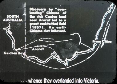
Diggers & Mining. The Chinese on the Gold Fields. Slide reads: Discovery by ''overlanding'' Chinese of the rich canteen load near Ararat led to a great rush to that field (1857). An anti-Chinese riot followed. Slide shows route that the Chinese would have walked. . . . Whence overlanded into Victoria. Markings: 25. Used as a teaching aid.hanimounteducation, tertiary, goldfields -
 Bendigo Historical Society Inc.
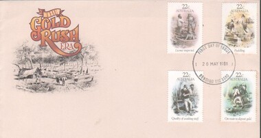
Memorabilia - First day issue envelope and stamp folder
First Day issue envelope and stamp pack for four 22 cent gold related stamps (Licence inspection, Puddling, Quality of washing stuff, & On route to deposit gold)First day of issue stamped envelope - 20/05/1981 Bendigo, Vic, 3550four gold related stamps., stamps -
 Bendigo Historical Society Inc.
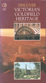
Book - Discover Victoria's Goldfield Heritage
128-page illustrated soft cover book entitled 'Discover Victoria's Goldfield Heritage. Includes Ballarat, Bendigo, Castlemaine and Stawell Written by Douglas Stone and Greg Dunnett First published 1993 by See Australia Guides Pty Ltd Printed and bound by Toppan, Hong Kong Includes route maps, city and town maps, town walks, scenic drives and bike rides.Handwritten in pen PETER RYALL on title page.goldfields, bendigo, ballarat, castlemaine, see australia guides -
 Bendigo Historical Society Inc.
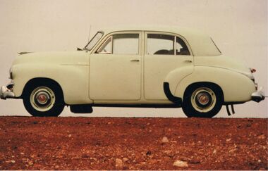
Photograph - PETER ELLIS COLLECTION: HOLDEN CAR
Coloured photograph. Old Holden car. Rocky hill. Back of photo reads: Between Coober Pedy and Marla on route to Alice Springs National Folk Festival Easter 1987. (then in different writing) This car, FJ Holden (1954-1956) was Peter Ellis's, previously used by Doc Robbins to map the Whipstick before Peter bought it.photo, individual, peter ellis car -
 Bendigo Historical Society Inc.
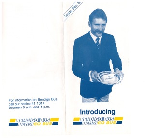
Ephemera - "Bendigo Bus" new routes, 1960 -1970s
BHS CollectionGlossy Brochure introducing "Bendigo Bus" new routes. Map of the new routes and information hotline.history, bendigo, merle lummis collection, bendigo bus -
 Bendigo Historical Society Inc.
Booklet - 7 Routes in and around Bendigo
A thirty-two pages booklet describing seven tourist routs for sightseeing in and around Bendigo. The routes are: 1) Bendigo. 2) Eppalock. 3) Castlemaine. 4) Maryborough. 5) Kyneton, Daylesford. 6) Wedderburn. 7) Whipstick Hill.On cover in blue pen the name John Hattam. Library sticker on spine 0059JWHbendigo, tourism, guide -
 Bendigo Historical Society Inc.
Document - BENDIGO EASTER FAIR COLLECTION: BENDIGO EASTER FAIR PROCESSION SCHEDULE AND RULES
Three pages document titled: Bendigo Easter Fair Society Easter Fair Processions detailing the schedule of event for Easter Saturday, Easter Monday and Easter Tuesday. The procession rules on the second page and map of the procession route on the third page.event, easter fair, bendigo easter fair -
 Bendigo Historical Society Inc.
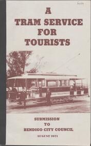
Book - A TRAM SERVICE FOR TOURISTS, 1971
A soft cover booklet 'A Tram Service for Tourists' a submission to Bendigo City Council, August 1971. Prepared by a sub-committee of the BendigoTrust. Includes a history of the tram system and options for a tourist tram route. This came about because the SEC, then current owners, were going to close the tram system.Bendigo Trust -
 Ballarat Tramway Museum
Document - Photocopies, Ballarat Tramway Museum (BTM), newspaper items - Ballarat closure, Mar. 1996
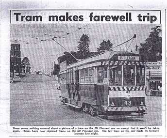
Photocopies of original newspaper clippings from the Ballarat Courier. Originals of cuttings held - see notes below. 278.1 - "Tram makes farewell trip" - photo of No. 43, near dusk on Mt. Pleasant route, fire station in background. - Sunday Sept. 5, 1971. - Courier Monday 6/9/1971 - A4 sheet. - (See Reg. Item 2907 for actual copy of cutting) 278.2. - "Last Journey for 39" - report on tram 39 last trip to Mt. Pleasant by Judy Graham - page 1 of Courier, 6/9/1971 - A4 sheet. - See Reg. Item 2908.1 for actual copy of cutting and 2908.2 for 2nd part on page 2. 278.3 - "Tram Change Uneventful" - report in the Courier of 24/8/1971, day after buses started on Victoria Street and photo of overhead dismantling (A4 sheet). - See Reg Item 1065 for actual copy of the cutting. 278.4. - "Many will miss tram" - report in Courier, Monday 23/8/1971 - following closure of Victoria St. route on 232/8/1971. Photo of No. 31 at Victoria St. (A3 sheet). (See Reg Item 1068 for actual copy of cutting). 278.5 - "Pieces of Tram History" - item in Courier of Wed. 22/9/1971 of tramway Supt. Mr. Denmead, handing over tokens and sample tickets to City of Ballarat - 2 photos - A3 sheet. - (See Reg Item 1846 for actual copy of cutting). Record updated 11/9/2013 for actual cuttings held. See Page 57 of KS Kings, "Ballarat Tramways"trams, tramways, ballarat, secv, closure -
 Ballarat Tramway Museum
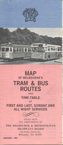
Map, Survey and Mapping for MMTB, "Map of Melbourne's Trams and Bus routes and all night services", Jan. 1967
Fold out sheet coloured map, 12 portions or folds, - title - "Map of Melbourne's Trams and Bus routes and all night services" map shows trams lines, route numbers, terminal points, bus routes, railway lines, blow up of city area with places of interest and key. On rear details, places of interest, suburb index, index to routes, first and last services, Sunday am services, all night bus services and locations of depots and head office. 2nd copy added 11-8-2006. Images of document - scanned to A3 size and overlapping added 30/10/13 On rear "out of date" stamp and 1 "cancelled" stamp - red ink.trams, tramways, melbourne, map, tram & bus services, all night services -
 Ballarat Tramway Museum
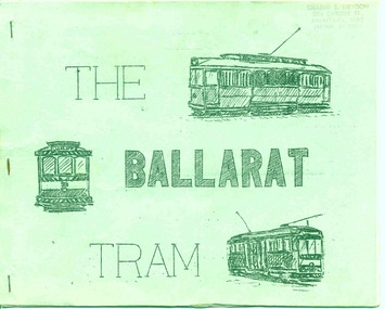
Book, A. Weston & Geoff Clark of North Sydney Boys High School, "The Ballarat Tram", Jul. 1971
Produced by the North Sydney Boys High School Railway club, prior to the closure of the Ballarat system - little else written and published at the time about the history and details of the system. A very good booklet for the time - produced entirely by the wax cut stencil process. Has a strong association with the people who prepared the document.Twenty page booklet on the history, operation and tramcars of Ballarat, produced by the Nth Sydney Boys High School Railway Club in July 1971. Printed on a wax cut stencil process, with green covers, drawings, maps, track layout, fleet list, gives tentative closure dates, route descriptions, sketches, stapled on edge. Title "The Ballarat Tram". Stapled on the left hand side. Three copies held - 3rd copy added 22/10/05. 4th copy added 11/10/2007 and image of cover added as well. pdf image of copy added 2/11/13 - to produce the scan, copy 2 was unstapled and filed loose - may not open properly in dbtext. find file and open directly. See Reg Item 6388 for the Bendigo version.3rd copy - page 3 - in black ink "Ballarat Tramway Preservation Society Catalogue No. 118", On top right hand corner "Graeme Breydon address stamp"trams, tramways, ballarat trams, secv, tramcars -
 Ballarat Tramway Museum
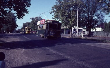
Slide - 35mm slide/s, Wal Jack, 11/03/1964 12:00:00 AM
Photo of Ballarat trams 28, 14, 42 en route to City and 38 in background going to Sebastopol, Drummond St. South, just north of Urquhart St., 11-3-1964. Trams 28 and 14 have small white stripe under dash canopy lights. 28 fitted with Castrol and 'Switch to electric cooking' ads, 14 has ads as well.'Ballarat Trams No. 28, 14, 42 to city, 38 Sebastopol. Drummond St. South, 11-3-64.' in blue inktramways, trams, drummond st. sth, sebastopol, tram 28, tram 14, tram 42 -
 Kew Historical Society Inc
Plan - Subdivision Plan, Erin Heights Estate, East kew, 1917
Pru Sanderson, in her groundbreaking ‘City of Kew Urban Conservation Study : Volume 2 - Development History’ (1988), summarised the periods of urban development and subdivisions of land in Kew. The periods that she identified included 1845-1880, 1880-1893, 1893-1921, 1921-1933, 1933-1943, and Post-War Development. These periods were selected as they represented periods of rapid growth or decline in urban development. An obvious starting point for Sanderson’s groupings involved population growth and the associated economic cycles. These cycles also highlighted urban expansion onto land that was predominantly rural, although in other cases it represented the decline and breakup of large estates. A number of the plans in the Kew Historical Society’s collection can also be found in other collections, such as those of the State Library of Victoria and the Boroondara Library Service. A number are however unique to the collection.The Kew Historical Society collection includes almost 100 subdivision plans pertaining to suburbs of the City of Melbourne. Most of these are of Kew, Kew East or Studley Park, although a smaller number are plans of Camberwell, Deepdene, Balwyn and Hawthorn. It is believed that the majority of the plans were gifted to the Society by persons connected with the real estate firm - J. R. Mathers and McMillan, 136 Cotham Road, Kew. The Plans in the collection are rarely in pristine form, being working plans on which the agent would write notes and record lots sold and the prices of these. The subdivision plans are historically significant examples of the growth of urban Melbourne from the beginning of the 20th Century up until the 1980s. A number of the plans are double-sided and often include a photograph on the reverse. A number of the latter are by noted photographers such as J.E. Barnes.The Erin Heights Estate in Kew included just seven lots in in Valerie Street. These were all that remained of this wartime subdivision, the other 11 allotments on Balfour and Belford Roads having already been sold. Balfour Road was to be only a temporary name as the street is currently called Windella Avenue. Now, the parkland opposite the subdivision is the reserve created from the route of the Outer Circle Railway. This Railway reached Kew East in 1925, but had been planned as far back as 1873. The development focuses on the benefits of living in Kew: being at the highest of Kew’s ‘suburbs’; being a good residential area; its rapid growth; and the proximity of the Kew East tram in High Street. In 1917, the electric tramline only extended to a terminus at the Harp of Erin hotel. The terminus is clearly represented on the plan.subdivision plans - east kew, erin heights estate -
 Glen Eira City Council History and Heritage Collection
Event Run-sheet and Map, "Booran Reserve Official Opening"
This run-sheet and map were used for the opening of Booran Reserve at the corner of Booran and Glenhuntly Roads on Tuesday 11 April 2017. The Reserve was officially opened by the Mayor, Cr. Mary Delahunty and The Hon. Philip Dalidakis, MP, Minister for Innovation. The run-sheet contains information about the Order of Proceedings of the opening ceremony. The map notes the locations of reserved parking, the route taken by Mayor Mary Delahunty and Minister Philip Dalidakis through the Reserve, and the speech and smoking ceremony site. The site of the Reserve was previously the Caulfield Service Reservoir.Black and white printed run-sheet, and green, teal, red, yellow, blue and khaki colour printed map -
 Port Fairy Historical Society Museum and Archives
Photograph, 1930's
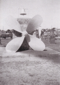
This Memorial was set up in memory of the nine people who drowned when the S.S.Casino sank in Apollo Bay in 1932.The cement plinth carries a bronze plaque with the names of the nine people who drowned on one side, the propeller, the wreck bell used to alert the lifeboat crew that there was an incident in the bay and for many years a large barometer that was consulted by the local fishermen before setting out to sea. A memorial Service is held each year on July the 10th at 11 am the time that the sinking took place. The Casino was about to celebrate her 50th year of plying the southwest trade route. Black and white photograph of Propeller from SS Casino as memorial memorial, s.s.casino, propeller, barometer, moyne river, sea -
 Port Fairy Historical Society Museum and Archives
Photograph, Early 20th Century
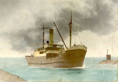
WANNON 567 gross tons. Lbd: 167'4" x 26'6" x 11'. Steel hulled, single screw steam coaster, coal burner (burnt briquettes when on Melbourne-Tassie run); 3cyl triple expansion steam engine, 61 nhp; built 1919 at Enkhuisen, Holland, as Boschpolder; 1920 as British flag Rawlinson; 1922 to Canterbury Steamship Co. Ltd. Lyttleton, N.Z, as Gale; 1935 to Belfast & Koroit Steam navigation Co. Ltd., Melbourne, renamed Wannon to ply the Portland, Port Fairy, Warrnambool, Apollo Bay, Melbourne trade route after the loss of S.S.Coramba off Phillip Island. World War 2 as (S-153) carried general equipment, stores to U.S. Army camps at islands such as Woodlark, Kiriwina, Goodenough. Also served at Lae, Finschhafen and Wewak. Returned to owners and in 1957 went to Hong Kong shipbreakers hand tinted photograph of shipship, boat, sea, river, s.s.wannon -
 Ballarat Tramway Museum
Photograph - Geelong Tramway "Summer Car"
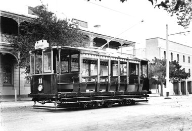
"Summer Car" 11 outside Mac's Hotel in Corio Tce. To the right is Strachan, Murray and Shannon's wool store whose facade still stands. The tramcar, shown in pristine condition was one of the two trailers motorised in 1913 with equipment identical to that of the Duncan & Fraser cars. They were built for use mainly on the new South route to the Barwon River. The coloured destination lights were from left: Red for GEELONG WEST, blank (later blue for the East route), white for SOUTH GEELONG and green for NEWTOWN. Side destination boxes have been added. Late 1913.Black and white print on paperNo. 1 inside a circle, and 13-7 written in ink on reverse. GSR7109/13/1/7 written on reverse in pencil.geelong tramway summer car 11, geelong streetscape, geelong tramway motorised trailer, geelong tram destination lights -
 Ballarat Tramway Museum
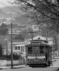
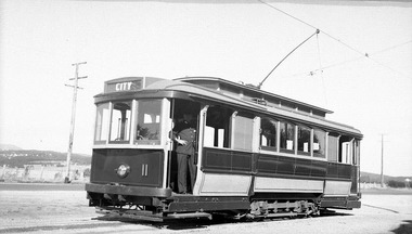
Photograph - Digital Image - tram 11 Sebastopol, c1937
Ballarat tram 11 at Sebastopol c1937 in the first SECV colour scheme or livery with cream rocker panels with the destination of City. Possibly, the photo was taken prior to the introduction of through routing of trams introduced in August 1937 when trams no longer terminated in the City at Grenville St but ran through the city to another terminus. See item 5578. Has the driver or motorman standing in the front doorway. Scan of negative collected by David Critchley of Sydney.Yield information about Ballarat 11, uniforms and the Sebastopol terminus c1938.Digital image of a scan of an original negative.tramways, trams, sebastopol, tram 11, uniforms, motormen -
 Bendigo Military Museum
Photograph - 4th Field Survey Squadron deployed on Operation NERIGHT, Queensland & Northern Territory, 1989
This is a set of 19 photographs taken in 1989 during 4th Field Survey Squadron’s deployment on Operation NERIGHT 89 in Queensland and the Northern Territory. It was a two-part operation in 1989 with work conducted in the areas of Camooweal and Weipa. Part 1 was the field completion of topographic maps conducted near Camooweal QLD, along the Barkley Highway on the border between NT and QLD, from the 12th of September to the 20th of October 1989. A Bell Kiowa LOH helicopter from 162 Recce Sqn supported topographic field completion. Operation NERIGHT 89 Part 2 was the acquisition of mapping control by GPS field parties utilising Texas Instruments TI4100 Global Positioning System receivers around Weipa on Cape York Peninsula from the 22nd of September to the 22nd of October 1989. Part 2 Two Bell UH-1H Iroquois helicopters from RAAF’s 35 Squadron were principally used to deploy GPS field parties. Identification photography of control points was taken by air camera operators in AAAvn Pilatus Porter aircraft from 173 Gen Spt Sqn fitted with an RC10 aerial camera. The two parts of the operation were conducted concurrently. This is a set of 19 photographs taken in 1989 during 4th Field Survey Squadron’s deployment on Operation Neright in Queensland & the Northern Territory. The colour photographs are on 35mm negative film and are part of the Army Survey Regiment’s Collection. The photographs were scanned at 96 dpi. .1) to .3) - Photo, colour, 1989. En-route to areas of survey operations. .4) to .5) - Photo, colour, 1989. Unidentified personnel relax next to river/waterhole. .6) - Photo, colour, 1989. Two Bell UH-1H Iroquois helicopters from RAAF’s 35 SQN utilised in the movement of GPS parties. .7) to .9) - Photo, colour, 1989. Unidentified soldier practices repelling from a UH1H Iroquois helicopter. .10) - Photo, colour, 1989. Inside the cockpit of a UH1H Iroquois helicopter. .11) - Photo, colour, 1989. Field Party camp with GPS equipment in foreground. Unidentified soldier prepares a meal. .12) - Photo, colour, 1989. GPS antenna plumbed over a survey ground mark. Witness post on left. .13) & .14) - Photo, colour, 1989. Unknown Cape York Peninsula beaches. .15) & .16) - Photo, colour, 1989. Dramatic fire next to base camp. .17) - Photo, colour, 1989. Aboriginal rock art at unknown location. .18) - Photo, colour, 1989. Aboriginal rock art at unknown location. L to R: unidentified, SPR Andrew Quin. .19) - Photo, colour, 1989. Aboriginal rock art at unknown location. LT Chris Topovsek..1P to .19P – There are no personnel identified. ‘1989 OP NERIGHT’ annotated on negative sleeve.royal australian survey corps, rasvy, 4 fd svy sqn, op neright 89 -
 Melbourne Tram Museum
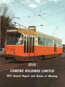
Document - Illustration/s, Letter/s, Commonwealth Engineering - Comeng, "Comeng Holdings Limited 1975 Annual Report and Notice of Meeting", Nov. 1975
.1 - Illustration of Z3 3 on the front cover of "Comeng Holdings Limited 1975 Annual Report and Notice of Meeting" with the Comeng Logo. Tram appears not to have been fitted with its route number and destination equipment. .2 - Letter on stippled paper, Comeng letterhead, with raised printing and watermarked "Z Mattpost" addressed to the donor supplying copies of the cover to him. Dated 19/11/1975. Signed by G. McArley Secretary.trams, tramways, z class, comeng, letterhead, annual reports, tram 3 -
 Melbourne Tram Museum
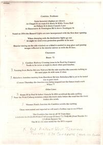
Document - Report, Swanston Trams, "Combino Problems", 2002
Set of 3 reports on A4 sheets about Combino trams. Only top sheet scanned. .1 - 4 pages with hand written notes titled "Combino Problems" - listing many issues on various route during the commissioning phase, includes an email dated 28/2/2002 from Russell Brooks re a meeting of 27/8/2002 and issues from the meeting. .2 - 3 A4 pages titled "Combino Meeting - Minutes" of a meeting of 26/9/2002, following from above meeting. .3 - 1 A4 page of a meeting of 23/11/2002 notes.trams, tramways, siemens, combino, unions, new trams, commissioning -
 Surrey Hills Historical Society Collection
Decorative object - Glass fairy lantern
Item believed to be from Empire Day celebrations held in Surrey Hills. The Empire Day movement was instituted in England in 1904 and a meeting of Surrey Hills residents on 24th May 1906, pledged to do all in their power to make the day a success. Founding members included Arthur 'Empire' Brooks, James 'Rule Britannia' Sneddon and Harry 'Mafeking' Garrett, whose nicknames stemmed from their activities. Empire Day celebrations from 1906-11 attracted tremendous enthusiasm as reported at the time with 40,000 people attending the procession. The procession included horse drawn floats from local businesses, a torchlight parade headed by mounted troopers and local school bands. Rows of lamps and paper Chinese lanterns strung across the streets and lit at night by candles, while every dwelling had it's own decorations. The Progress Association revived the celebrations between 1933 and 1938 and while the route of the procession varied between these years, it would end with a 'monster bonfire' at Beckett Park.Cobalt blue glass fairy lantern with diamond quilt or pineapple pattern. Wire handle with twisted join. Remnants of candle/tealight in bottom.empire day, empire day celebrations, surrey hills progress association, mr james sneddon, mr arthur brooks, mr harry garrett, chinese lanterns, kitchen brothers, john bull, beckett park, canterbury road, union road, surrey gardens, fairy lantern -
 Melbourne Tram Museum
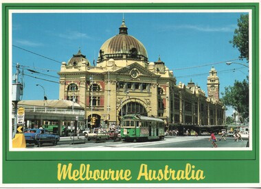
Postcard - Nu-color-Vue - Flinders St Station - W2 637, Nucolorvue Publishing
Postcard - image of Flinders Street Railway Station, corner of Swanston Street with W2 637 (Spencer St, route 48), possibly late 1970s or early 1980s. Tram W6 978 is in Swanston Street.Demonstrates an iconic Melbourne image, Flinders Street Station and a W class tramPostcard colour - Flinders St Station - Nu-color-vue card number 11 ML 138, NCV 4986 Divided back.trams, tramways, flinders street station, w2 class tram, tram 637, swanston street