Showing 272 items
matching settlement house
-
 Box Hill Historical Society
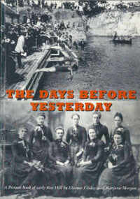
Book, Finlay, Eleanor,Morgan, Marjorie, The days before yesterday: a picture book of early Box Hill, 1993
Pictorial history of early years of settlement in Box Hill up to 1930 including photographs of houses, schools, churches, people, entertainment, wars, transport, commerce, government and the City. 87 pageshistory, box hill, photographs, houses, schools, churches, people, entertainment, war, transport, commerce, government -
 Inglewood & District Historical Society
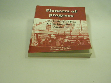
Catto Family Book, Cambridge Press, Pioneers of Progress - Jennifer Lovell & Norma Catto, 2007
Relating the story of two branches of the Catto family who emigrated to Australia in the early 19th century. John Catto (1802-1872) and John Catto (1830-1918) Detailed history of the early settlement and continued residence of the Loddon district by the Catto family (many references to other families also)Soft cover book. 266 pages. Red and white photographic cover. History of two Catto families in Loddon District.ISBN 9780646476766. Limited Edition 2007 / Dedicated to the memory of Norma and Graeme Catto.catto early history in loddon -
 Koorie Heritage Trust
Book, Public Record Office of Victoria, Victorian Aborigines 1835-1901 : a resource guide to the holdings of the Public Record Office, Victoria / prepared by the Public Record Office of Victoria, 1984
Includes a brief history of the Board for the Protection of Aborigines (and its forerunners) and extracts from the papers of M. Sievewright, C.W. Sievewright (on a murder case), W. Thomas (on stone houses), W.A.P. Dana (on native police), E.S. Parker; (biography of Merringoondeet), P. Sohier (on phrenology); Coranderrk revolt; Lake Tyers; Ramahyuck64 p. : ill ; facsims, ports. ; 21 cm.Includes a brief history of the Board for the Protection of Aborigines (and its forerunners) and extracts from the papers of M. Sievewright, C.W. Sievewright (on a murder case), W. Thomas (on stone houses), W.A.P. Dana (on native police), E.S. Parker; (biography of Merringoondeet), P. Sohier (on phrenology); Coranderrk revolt; Lake Tyers; Ramahyuckphrenology. | public records -- victoria. | psychology - cognition - intelligence. | settlement and contacts - colonisation - 1788-1850. | settlement and contacts - colonisation - 1851- crime - against persons. | education. | government policy - initial period and protectionism - 1788-1850. | government policy - initial period and protectionism - 1851-1900. | government policy - state and territory - victoria. | settlement and contacts - government settlements, reserves. | law enforcement - police - native police. -
Koorie Heritage Trust
Book, Billot, C. P. (Cecil Philip), John Batman : the story of John Batman and the founding of Melbourne, 1979
Founder of Melbourne no biography since 1867, the manner of his death may be the reason. Documentary works from a variety of primary sources in State libraries and Public Records have assisted in this work.xiii, 330 p., 8 p. of plates : ill., maps, ports. ; 24 cm.Founder of Melbourne no biography since 1867, the manner of his death may be the reason. Documentary works from a variety of primary sources in State libraries and Public Records have assisted in this work.batman, john, 1801-1839. | victoria. port phillip bay region. settlement. batman, john, 1801-1939. biographies. | land settlement -- victoria -- port phillip bay district. | port phillip bay region (vic.) -- history. -
Koorie Heritage Trust
Book, Library Council of Victoria, Trespassers and intruders : the Port Phillip Association and the founding of Melbourne, 1982
Catalogue for an exhibition held at the State Library of Victoria in 1982 presenting the documents (housed in the La Trobe Library) which led to the founding of Melbourne. Scattered references to Aboriginal people. Deals with early settlement and the founding of Melbourne. Brief descriptions of personalities involved at that time, detailed annotations.[26] p. : ill., facsims. ; 25 cm. Catalogue for an exhibition held at the State Library of Victoria in 1982 presenting the documents (housed in the La Trobe Library) which led to the founding of Melbourne. Scattered references to Aboriginal people. Deals with early settlement and the founding of Melbourne. Brief descriptions of personalities involved at that time, detailed annotations.la trobe library -- catalogs. | port phillip association. | libraries. melbourne. la trobe library. stock: documents associated with port phillip association | land settlement -- victoria -- melbourne -- bibliography -- catalogs. | land settlement -- victoria -- melbourne -- bibliography. | land settlement -- victoria -- melbourne -- exhibitions. -
Whitehorse Historical Society Inc.
Document, Forest Hill, Boyle, Dudley
Information on early settlement of Forest Hill and names of pioneers dating back to 1864.Information on early settlement of Forest Hill and names of pioneers dating back to 1864.Information on early settlement of Forest Hill and names of pioneers dating back to 1864.bolster family, bayle family, mcclare family, oru? family, read family, cawise? family, peacock family, jayau? family, mcarthur family, gregory family, forest hill holiday house, forest hill residents kindergarten -
 Whitehorse Historical Society Inc.
Report, Abraham Rooks holding, ca 1870
Inspection of Abraham Rook's holding of 80 acres including description of house, outhouse, fencing, waterhole, stable by the Crown Lands Bailiffthompson, robert, rooks, abraham, land settlement -
 Ballarat Heritage Services
Image - Black and White, Leeton Irrigation Settlement, c1950, c1950
A black and white image of a wide street in Leeton Irrigation Settlement.corowa, customs house, river, bridge -
 Ballarat Heritage Services
Photograph - Image - Colour, Clare Gervasoni, The First House at Ercildoun, 2008, 10/05/2008
... settlement The First House Learmonth Bros (built 1837) made from hand ...The photograph was taken during an opening of the Ercildoun property during Ballarat Heritage Weekend. Colour image of stone and weatherboard building which was the initial shelter of the Learmonth Brothers who squatted at Ercildoun.The First House Learmonth Bros (built 1837) made from hand split ? and hand made bricks. ?garden, ballarat heritage weekend, ercildoun, ercildoune, architecture, squatter, settlement -
 Ballarat Heritage Services
Photograph - Image - Black and White, Port Campbell Coastal Scene, c1925, c1925
Permission to plant the pines was given by the Heytesbury Shire in March 1915. Black and white image of a coastal settlement at Port Campbell. The two storeyed house to the right is Ocean House (built 1918). Next to it is Port Campbell Hotel.coast, beach, river, mouth, port campbell, ocean house, port campbell hotel -
 Ballarat Heritage Services
Photograph - Photograph - Colour, Former Lake Condah Aboriginal Mission, 17/04/2016
The Lake Condah Mission site includes bluestone ruins and a reconstructed timber building, as well as the cemetery which were part of the original settlement. With European settlement in the 1830s came conflict. Gunditjmara people fought for their land during the Eumerella wars, which lasted more than 20 years. As this conflict drew to an end in the 1860s, many Aboriginal people were displaced and the Victorian government began to develop reserves to house them. Many Aboriginal people refused to move from their ancestral land and eventually the government agreed to build a mission at Lake Condah, close to some of the eel traps and within sight of Budj Bim (Mt Eccles). The mission opened in 1867. The Mission was formally closed in 1918, and Aboriginal people were forced off the Mission, some moving to Lake Tyers. The Gunditjmara protested against the Mission’s closure and many continued to reside in the buildings until the majority of the reserve land was handed over to the Soldier Settlement Scheme in the 1940s. The mission was destroyed by the government in the 1950s in an effort to force the integration of Gunditjmara people with the general community but the Gunditjmara people continued to live in the area and protect their heritage. The mission lands were returned to the Gunditjmara in 1987. Lake Condah Mission is a place with special meaning to the Gunditjmara community - as a community meeting place, an administrative centre, a symbol of political struggle and a link to family histories. As a result the Gunditjmara community do not want open public access to this site. Key Features of Interest Ruins of stone cottages and plot remains of buildings such as the church Reconstructed dormitory building (https://www.budjbim.com.au/visit/cultural-sites/lake-condah-mission/?gclid=EAIaIQobChMIz6j36ZvF-QIV8ZhmAh2tmA3qEAAYASAAEgLxrvD_BwE, accessed 2022)Colour photographs of the former Lake Condah Aboriginal Missionlake condah, lake condah aboriginal mission, aborigines, aboriginal, gunditjmara, eumerella wars -
 City of Ballarat Libraries
Photograph - Card Box Photographs, Pioneer Settlement Selection, Ballarat c1870
This selection was located in Grenville and owned by David Alfred Pattenden. His father, the man leaning on the fence, was a journalist.pioneer settlement selection, ballarat, grenville, private dwelling, house, david alfred pattenden -
 Ballarat Heritage Services
Photograph - Photograph - Colour, Lisa Gervasoni, Remains of Angus McMillan's Bushy Park Home, 2014, 07/06/2014
Angus McMillan was born in 1810 at Glenbrittle in the Isle of Skye. He was one of fourteens sons of Ewan McMillan. Angus McMillan arried i New South Wales in January 1839, and became an overseer for Captai nLachlan Macalister. I n 1839 Angus McMillan travelled south. He settled for a time on Jame MacFarlane's statin at Currawong. IOn 28 May 1839 Angus MacMillan stated travelling southward toward the coast. Angus Macmillan named the Avon River after the river of the same name in his native Scotland. In 1840 he established a pastoral run at Bushy Park, near Maffra. William Odell Raymond established a run in the area in 1842, and built his house, Strathfieldsaye, during 1848–54. European settlement did not take place without resistance, and in return, massacres were inflicted by Angus McMillan and others on Gunai people, especially between the years of 1840 and 1850. (wikipedia) The first application for the 'Bushy Park' run appears in the “Port Phillip Gazette” on 13 August 1843. It was taken up by Angus McMillan, who also took up the 'Boisdale' run for his employer Lachlan Macalister at the same time. In March 1844 a Licence to occupy the 16,000 acre 'Bushy Park' was granted to McMillan. In the late 1840s Andrew Martin and Matt McCraw built Angus McMillan's Bushy Park homestead. Aboriginal killings in Gippsland area most often were never formally recorded, but lived on in folklore, mainly in place names pinpointing what some historians now refer to as "massacres", and others as "conflicts". There is Boney Point, on Lake Wellington, Butchers Creek, near Metung, Slaughterhouse Gully, at Buchan, Skull Creek, at Lindenow, and, notoriously, Warrigal Creek, at Woodside. "Here, according to a couple of contemporary - though not eyewitness - reports, between 50 and 150 blacks were killed in an orgy of revenge after the murder and mutilation of a leading Scots settler, Ronald Macalister. If anybody had any doubts about the fitness of commemorating McMillan's name, no one voiced them then. Gippsland was, and still is, dotted with stone cairns tracing his route from Omeo, down the Tambo Valley to the fertile plains where he was to make (and lose) his fortune. And where, according to a growing body of opinion, he was to lead the "Highland Brigade", a band of armed settlers, against the Kurnai. History is fiction agreed on, and it is written by the winners. For most of the past 150 years, McMillan has been hailed as a trail-blazing pioneer. The legend began to crumble 20 years ago with publication of new histories, which at first outraged Gippsland historical societies and old residents, but which have gradually changed the way McMillan is viewed. ... Still, not all McMillan's contemporaries agreed with the "Highland Brigade" and its methods. Henry Meyrick, an English-born squatter, wrote to relatives in disgust about his neighbours. He estimated that 450 had been killed, and wrote: "Men, women and children are shot down whenever they can be met with. Some excuse might be found for shooting the men by those who are daily getting their cattle speared, but what they can urge in their excuse who shoot the women and children I cannot conceive." (http://www.theage.com.au/articles/2002/04/26/1019441303552.html, accessed 20 September 2016.) The Gippsland electorate is called 'McMillan' in his honour. Photographs of the remains of a timber home used by squatter Angus McMillan at his "Bushy Park" property on the Avon River. angus mcmillan, bushy park, avon river, squater -
Lakes Entrance Regional Historical Society (operating as Lakes Entrance History Centre & Museum)
Photograph, 1/06/1950 12:00:00 AM
... Institute Hall 04738.1 11 x 14 cm Houses Land Settlement Waterways ...Also a black and white photograph of the prize car Austin A 40 outside the RSL club rooms at the Mechanic Institute Hall 04738.1 11 x 14 cmBlack and white photograph of Mr Mann receiving first prize in Art Union draw in photoi are L to R J G Gray Pres, J Bayliss Sec, G Reid Treas G Graham Hon Organiser, Mr Mann, W Jennings VP, E Carstairs VP, V J Carstairs, J Bulmer, ET Harbeck taken at Lakes Entrance Victoriahouses, land settlement, waterways -
Lakes Entrance Regional Historical Society (operating as Lakes Entrance History Centre & Museum)
Photograph, 1991 c
Also three colour photographs of Mitchell River at Bairnsdale taken autumn 1991 04605.1 04605.2 04605.3 10 x 15 cmColour photograph of Mitchell River taken from across the river looking back towards picnic area on right, site of old swimming pool below Court House Bairnsdale Victoriafarm, primary industry, settlement, waterways -
Lakes Entrance Regional Historical Society (operating as Lakes Entrance History Centre & Museum)
Photograph, 1900 c
... Entrance gippsland Second identical copy 04618.1 Houses Land ...Second identical copy 04618.1Black and white photograph of a bark hut showing walls of vertical sheets of bark held in place by horizontal battons. On the roof overlapping sheets of bark are held in place by a horizontal log attached to the saddle pole on the roof ridge by vertical timbers. Nails were not used wooden pegs or greenhide strips kept the frame stable. This building believed to be in the Lake Tyers area Victoriahouses, land settlement -
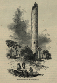 Ballarat and District Irish Association
Image, Round Tower at Monasterboice, c1864, c1864
The historic ruins of Monasterboice are of an early Christian settlement north of Drogheda in County Louth, Ireland. It was founded in the late 5th century by Saint Buithe who died around 521, and was an important centre of religion and learning until the founding of nearby Mellifont Abbey in 1142. The site houses two churches built in the 14th century or later and an earlier round tower, but it is most famous for its 10th century high crosses. The round tower is about 35-metres tall, and is in very good condition, although it is not possible to go inside. The passage of time has laid down layers of earth so now the doorway is almost at ground level. The monastery was burned in 1097. The 5.5-metre Muiredach's High Cross is regarded as the finest high cross in the whole of Ireland. It is named after an abbot, Muiredach mac Domhnaill, who died in 923 and features biblical carvings of both the Old and New Testaments of the Bible. The North and West crosses are also fine examples of this kind of structure, but these have suffered much more from the effects of the weather. (http://en.wikipedia.org/wiki/Monasterboice)Image of a round tower in a graveyard. It is the Round Tower at Monasterboiceballarat irish, monsasterboice -
 Mt Dandenong & District Historical Society Inc.
Photograph, George Barber's Home Forest Edge after 1912 Looking South West, c1912
George Barber built a homestead later named Forest Edge on Barber's Road and lived there with his wife Sarah Ann (nee Richardson).Black and white photograph showing the side view of a house and three outbuildings. Reverse of photograph has handwritten description by John Lundy-Clarke.George Barber's home on bend of Barber's Road on Lot 25, Village Settlement. Showing passionfruit plantation. Buggy shed top right. Hay shed lower right. Stables, cart shed and men's quarters lower left about 1912. Photo copied by JLC in 1973.forest edge, george barber, sarah ann barber, kalorama, barber's road -
 Mt Dandenong & District Historical Society Inc.
Photograph, View Up Valley At Kalorama
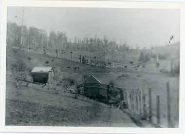
John Lundy-Clarke grew up in the Kalorama/Mt Dandenong area and later in life (1972-74) began to write a comprehensive history of the area working from an original settlement map in an effort to cover all areas. The building in the centre of the photograph is 'Kia-Ora' guest house. Situated on Barber’s Road, ‘Kia-Ora’ was built in 1912 by George Barber. It was later leased by a Mrs Pemberthy. “Kia-Ora’ was one of four places connected when the telephone was brought into the district in 1912. The other places were ‘Mountjoy’, ‘Cherry Farm’ and ‘Callum House’. ‘Kia-Ora’ was burnt down in 1924. Black and White copy of section of a Rose Series postcard. Shows view up the valley at Kalorama with a decorative building centre middle of photograph. Handwritten description by John Lundy-Clarke on reverse.View up valley at Kalorama from near junction of Barbers and Doughty’s Rds. “Kia Ora” guest house in centre. Paynter’s “Iona” top left with “Kalorama” to its right. About 1912. Rose Series copied by JLC 1973.kalorama, kalorama valley, john lundy-clarke, barbers road, george barber, kia-ora, guest house, iona -
 Mt Dandenong & District Historical Society Inc.
Photograph, View of the Kalorama Valley c1905
John Lundy-Clarke grew up in the Kalorama/Mt Dandenong area and later in life (1972-74) began to write a comprehensive history of the area working from an original settlement map in an effort to cover all areas. This photograph c1905 is looking up from George Barber's house 'Forest Edge' on Barbers Road. 'Forest Edge' was built c1898 and was the home of George Barber and his wife Sarah Ann (nee Richardson). The buildings in the foreground are the stables and hayshed.Black and white photograph showing two small buildings in the foreground with cleared hills behind. Handwritten decription on back by John Lundy-ClarkeA 1905 view of the Kalorama Valley towards the Gap. Barbers stables in foreground with hayshed on left. Tait’s house in centre of picture with Logans in the same fold above the hayshed. “Kalorama” is centre of Gap with Paynter’s “Iona” on its left with stables to its left. It was from one of these trees on the top left that the runaway log was cut that leaped over Barbers Road (at the top edge of the cleared land) then over Logan’s house in one bound in 1930.george barber, sarah ann barber, john lundy-clarke, forest edge -
 Mt Dandenong & District Historical Society Inc.
Photograph, View From Ernest Road To Site Of "Kia-Ora"
John Lundy-Clarke grew up in the Kalorama/Mt Dandenong area and later in life (1972-74) began to write a comprehensive history of the area working from an original settlement map in an effort to cover all areas. The photograph taken c1973 from Ernest Road looks over the site of the Kia-Ora guesthouse which is marked by the oalm tree that can be seen at the front of the flat roof close to the gum tree trunk. Situated on Barber’s Road, ‘Kia-Ora’ was built in 1912 by George Barber. It was later leased by a Mrs Pemberthy. “Kia-Ora’ was one of four places connected when the telephone was brought into the district in 1912. The other places were ‘Mountjoy’, ‘Cherry Farm’ and ‘Callum House’. ‘Kia-Ora’ was burnt down in 1924.Black and white photograph showing a house with water tank in right foreground and another flat roof centre foreground. There is a handwritten description by John Lundy-Clarke on the reverse.View 1973 from corner of Ernest Rd and Outlook Drive Lot 24 Village Settlement looking over the site of “Kia Ora” to the pioneers clearings. The palm tree seen above the flat roof (Rex) on left, is on the exact site of “Kia Ora”. Photo JLCernest road, john lundy-clarke, kia=ors, guest house, guesthouse -
 Mt Dandenong & District Historical Society Inc.
Photograph, View Over Roof of "Kalorama"
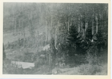
Taken in 1908, this photograph, though rather blurry, gives an indication of the location of the early settler properties in the valley in relation to one another. European trees have been planted at 'Kalorama' , the first home of Ellis Jeeves. John Lundy-Clarke grew up in the Kalorama/Mt Dandenong area and later in life (1972-74) began to write a comprehensive history of the area working from an original settlement map in an effort to cover all areas.Black and white photograph looking across hillside with large trees and rooftops visible. Handwritten description on reverse by John Lundy-Clarke.1908 View over roof of “Kalorama” towards the Falls. Paynter’s house on LOT 29 in low centre (now “Yosemite”). Pimms house on LOT 19 above Paynters and beyond scrub. Logan’s house faint above left of “Kalorama”. Dunbar’s LOT 20 beyond Pimm’s orchard. Gum trees on right were on Price’s LOT 19 now Tosari Rd area. It was one of these that figured in the episode of the runaway log in 1930. It leaped in one bound over Barbers Road at bottom of scrub in centre of picture then over Logan’s house.kalorama, ellis jeeves, jeeves -
 Mt Dandenong & District Historical Society Inc.
Photograph, Walker's LOT 2
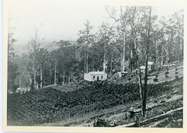
Lot 2 was bought by Harry Walker in the early 1900s. Harry was married to Eva Hand, one of the six daughters of Thomas and Eliza Hand. Harry cleared the land and planted half with raspberries that remained productive until c1928. Harry's son William took over the property. The land was cut in half when the new CRB road went through in the early 1920s. John Lundy-Clarke grew up in the Kalorama/Mt Dandenong area and later in life (1972-74) began to write a comprehensive history of the area working from an original settlement map in an effort to cover all areas.Black and white photograph showing a single storey white house in the centre surrounded by crops. Handwritten description on reverse by John Lundy-Clarke.VIEW 1908 OVER LOT 2 SECTION 1 VILLAGE SETTLEMENT. TAKEN FROM RIDGE ROAD THEN MAIN ROAD FROM HALFWAY BETWEEN MOUNTJOY AND FALLS RD. CRB MAIN RD RUNS BEHIND WALKER’S HOUSE. The house seen in the vista among the tall trees beyond the raspberry patch is “Forest Edge” which was George Barber’s home when the picture was taken. The tall trees to the right of the vista were on Price’s LOT 18 and it was while cutting up one of these for firewood that a length of log weighing about ½ a ton got away downhill and leaped in one bounce over Barbers Road and Logan’s house – 1931.harry walker, william walker, eva hand, crb road, raspberries, kalorama -
 Mt Dandenong & District Historical Society Inc.
Photograph, View of Kalorama Gap 1905
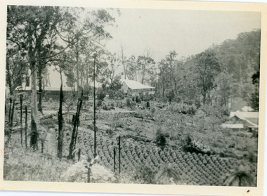
Kalorama Gap viewed from the South West in 1908. Ellis Jeeves' 'Mountjoy' is in the centre with the stables to the left. The raspberry patch belongs to Harry Walker and the building centre right to Edward Joseph Price. John Lundy-Clarke grew up in the Kalorama/Mt Dandenong area and later in life (1972-74) began to write a comprehensive history of the area working from an original settlement map in an effort to cover all areas.Black and white photograph showing an extensive raspberry crop in the foreground with a house and outbuilding in the centre and another dwelling centre right. Handwritten description on reverse by John Lundy-Clarke. 1908 view of Kalorama Gap taken from corner of Village Settlement LOTS 2 and 3 on Ridge (then Main Road) which crosses centre of picture with Walker’s driveway dropping left. Walker’s raspberry patch in foreground. “Mountjoy” in centre of picture with coaching stables on left. Price’s house and shop on right showing large cross room used by the Village Settlers for dancing. Mrs Hand’s “Beulah Tearooms” later Mt Dandenong North Post Office is above Price’s roof.kalorama gap, kalorama, harry walker, walker, edward joseph price, raspberry, mountjoy -
 Mt Dandenong & District Historical Society Inc.
Photograph, Walker's LOT 2
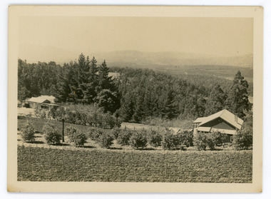
Harry Walker's property would have been run by his son William in 1922. When the CRB Road cut through the property William planted plum trees on the opposite side. These are visible in this photo. An extensive raspberry crop is in the foreground. The building over the road on the left hand side is the corn and produce store built by Edward John Price (son of Edward Joseph Price) to capitalise on the CRB Road cutting through the Price farm. John Lundy-Clarke grew up in the Kalorama/Mt Dandenong area and later in life (1972-74) began to write a comprehensive history of the area working from an original settlement map in an effort to cover all areas.Small black and white postcard showing a crop in foreground with a house to the right. A road passes through the centre with a house on the left on the opposite side of the road. A view to the ranges in the distance. A handwritten description on reverse by John Lundy-Clarke.View at Kalorama. View over LOT 2 (Walkers) 1922.harry walker, william walker, crb road, raspberry, edward john price, edward joseph price, produce store, store -
 Mt Dandenong & District Historical Society Inc.
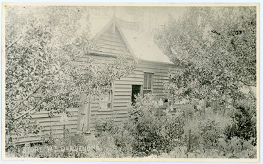
Photograph, Home and Shop of Edward Joseph Price
John Lundy-Clarke grew up in the Kalorama/Mt Dandenong area and later in life (1972-74) began to write a comprehensive history of the district working from an original settlement map in an effort to cover all areas. Edward Joseph Price was the first settler to take up a lot (Lot 1, Section 1) in the Village Settlement. He built a slab hut and brought up his family in 1896. This photograph shows a newer home built in 1908. It had a section used as a shop and also had a large room built that was to be used for public gatherings. Health department regulations led to this being impossible. The house faced Ridge Road.Black and white close up photograph showing a building made from wooden boards with trees in the front. Reverse of photograph has handwritten description by John Lundy-Clarke.On Front STORE MT DANDENONG On Reverse Home and Shop of Edward Joseph Price LOT 1 SECT 1 erected in 1908 on site of earlier dwelling from which goods had been sold without a special room for shop. In picture the room on the extreme left was bedroom for boys Charlie and Ted (Edward John). Under the gable was a large room planned for public use but never used owing to Health Department Regulations. The narrow door (open) and window were the shop which was the district’s first newsagency. Window behind leaves at right was the kitchen. 1908-1912. Gabled portion is now part of home “Mirra Laken” 1975edward joseph price, store, shop -
 Mt Dandenong & District Historical Society Inc.
Photograph
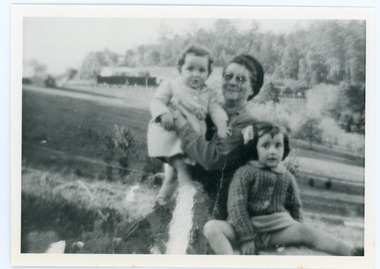
The Wenborn family acquired Ferguson's Lot 19 of the Village Settlement where the original Mount Dandenong School was opened in a shed. WH Collom owned the land after Ferguson and then it passes to the Wenborns. This photograph, taken c1942, shows Ivy Wenborn with her daughters Mary and Joan. John Lundy-Clarke grew up in the Kalorama/Mt Dandenong area and later in life (1972-74) began to write a comprehensive history of the area working from an original settlement map in an effort to cover all areas.Black and white photograph of a woman nursing a young girl Another young girl is seated at her right.Behind is a view of trees and a house. Handwritten inscription on reverse by John Lundy-ClarkeWenborn Family. Looking across what is now Kalorama Park showing Norman Jeeves' house behind the hedge to the left of the child.wenborn, ivy wenborn, mary wenborn, joan wenborn, norman jeeves, kalorama park, jeeves -
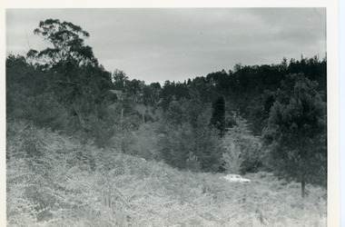
 Mt Dandenong & District Historical Society Inc.
Photograph, View From Doughty's Road 1974
John Lundy-Clarke grew up in the Kalorama/Mt Dandenong area and later in life (1972-74) began to write a comprehensive history of the area working from an original settlement map in an effort to cover all areas. This photograph shows approximately the same area as photograph number KAL0193 but is taken 60 years later. The trees have grown much taller and the buildings changed. On the site of the Paynter house 'Iona' there is now the 'Yosemite' (Villa Toscana) accommodation. The pavilion in the centre of the photo is the site of 'Kalorama', home of early pioneer Isaac Jeeves. The photograph is taken looking up towards The Gap (FiveWays).Black and white photograph showing a forested area with clear sites. Roofs of buildings can be clearly seen. Handwritten inscription on reverse by John Lundy-ClarkeView from near Doughty’s Rd looking north up valley to Kalorama Gap in Jan 1973. Tiny roof in centre is pavilion on site of “Kalorama”. Long roof to its left is Yosemite Motel on site of “Iona”.paynter, kalorama, iona, yosemite, villa toscana, five ways, the gap -
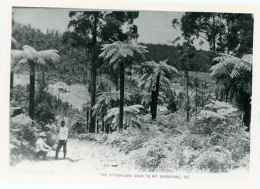 Mt Dandenong & District Historical Society Inc.
Photograph, View From Doughty's Road 1913
Mt Calvin, the homestead of Jeanie and Willie Richardson can be clearly seen in the clearing above the men in the picture. The white roof of the Barber homestead is on the right of the picture. A landslide in 1934 destroyed the tree ferned area. John Lundy-Clarke grew up in the Kalorama/Mt Dandenong area and later in life (1972-74) began to write a comprehensive history of the area working from an original settlement map in an effort to cover all areas.Black and white photograph that is a copy of a Rose series postcard titled 'The Picturesque Road to Mt. Dandenong. Vic.' It shows two men (probably Rose Series employees), one sitting and one standing at the edge of an unmade road. Large tree ferns line the roadside. Handwritten inscription on reverse by John Lundy-Clarke1913 View east from Doughty’s Road showing Jeannie Richardson’s home through the gap in the trees. A little to the right of and below centre of picture can be seen George Barber’s home with Barbers Road turning around the wagon shed that was a little up the hill from the house. The tree ferns in the picture were destroyed in the landslide of 1934. In the distance at the right can be seen F.M. Childs Homestead complex with the Richardson paddocks beyond it.mt calvin, jeanie richardson, willie richardson, george barber, landslide, tree fern -
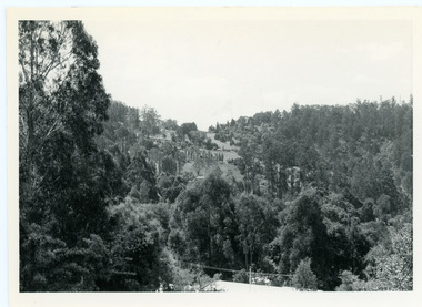
 Mt Dandenong & District Historical Society Inc.
Photograph, View Up Valley Towards Kalorama Gap 1973
John Lundy-Clarke grew up in the Kalorama/Mt Dandenong area and later in life (1972-74) began to write a comprehensive history of the area working from an original settlement map in an effort to cover all areas. This photograph would have been taken to show the changes in the area over the years. Kalorama Gap is now called Five Ways. 'Kia-Ora ' was a guest house built by George Barber. It is no longer standing.Black and white photograph showing a bush scene with a white car visible on the right. Handwritten inscription on reverse by John Lundy-Clarke1973 View up Valley towards Kalorama Gap from what was Crooks LOT 24. White car is on Barbers Road and site of “Kia Ora” is to right of it.kalorama, kalorama gap, five ways, barbers road, george barber, kia-ora