Showing 19396 items matching "shipwreck-coast"
-
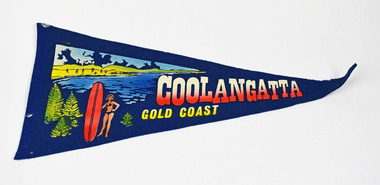 National Wool Museum
Pennant
COOLANGATTA GOLD COASTcoolangatta, queensland -
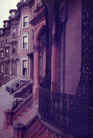 Robin Boyd Foundation
Slide, Robin Boyd, 1956-1957
Robin Boyd developed a close friendship with the founder of the Bauhaus in Weimar Germany, Walter Gropius, who had moved to the USA in the 1930s. Through this connection, Boyd was invited to be the Massachusetts Institute of Technology (MIT) Bemis Professor at the School in the North American academic year 1956-7. Robin and Patricia Boyd, with their youngest daughter Suzy, were based in Cambridge, Massachusetts for the year. Boyd gave some lectures at MIT and he was also invited to give lectures at many other universities, allowing him to travel widely within the USA, especially on the East Coast. This gave him the opportunity to meet architects like Frank Lloyd Wright, Eero Saarinen, Paul Rudolph and many others, and visit the offices of Skidmore, Owings and Merrill, and places like Taliesin and the General Motors Technical Center Detroit. On the way home, the Boyds visited London, Berlin, Paris and Le Corbusier’s Ronchamp Chapel in France.Colour slide in a mount. Brownstone streetscape east coast, possibly New York or Boston, USAMade in USA / Patentedmit bemis professorship, mit, robin boyd, slide -
 Flagstaff Hill Maritime Museum and Village
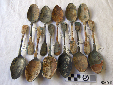
Spoons, Before 1878
Recovered from the wreck of the Loch Ard. HISTORY OF THE LOCH ARD The LOCH ARD belonged to the famous Loch Line which sailed many ships from England to Australia. Built in Glasgow by Barclay, Curdle and Co. in 1873, the LOCH ARD was a three-masted square rigged iron sailing ship. The ship measured 262ft 7" (79.87m) in length, 38ft (11.58m) in width, 23ft (7m) in depth and had a gross tonnage of 1693 tons. The LOCH ARD's main mast measured a massive 150ft (45.7m) in height. LOCH ARD made three trips to Australia and one trip to Calcutta before its final voyage. LOCH ARD left England on March 2, 1878, under the command of Captain Gibbs, a newly married, 29 year old. She was bound for Melbourne with a crew of 37, plus 17 passengers and a load of cargo. The general cargo reflected the affluence of Melbourne at the time. On board were straw hats, umbrella, perfumes, clay pipes, pianos, clocks, confectionary, linen and candles, as well as a heavier load of railway irons, cement, lead and copper. There were items included that intended for display in the Melbourne International Exhibition in 1880. The voyage to Port Phillip was long but uneventful. At 3am on June 1, 1878, Captain Gibbs was expecting to see land and the passengers were becoming excited as they prepared to view their new homeland in the early morning. But LOCH ARD was running into a fog which greatly reduced visibility. Captain Gibbs was becoming anxious as there was no sign of land or the Cape Otway lighthouse. At 4am the fog lifted. A man aloft announced that he could see breakers. The sheer cliffs of Victoria's west coast came into view, and Captain Gibbs realised that the ship was much closer to them than expected. He ordered as much sail to be set as time would permit and then attempted to steer the vessel out to sea. On coming head on into the wind, the ship lost momentum, the sails fell limp and LOCH ARD's bow swung back. Gibbs then ordered the anchors to be released in an attempt to hold its position. The anchors sank some 50 fathoms - but did not hold. By this time LOCH ARD was among the breakers and the tall cliffs of Mutton Bird Island rose behind the ship. Just half a mile from the coast, the ship's bow was suddenly pulled around by the anchor. The captain tried to tack out to sea, but the ship struck a reef at the base of Mutton Bird Island, near Port Campbell. Waves broke over the ship and the top deck was loosened from the hull. The masts and rigging came crashing down knocking passengers and crew overboard. When a lifeboat was finally launched, it crashed into the side of LOCH ARD and capsized. Tom Pearce, who had launched the boat, managed to cling to its overturned hull and shelter beneath it. He drifted out to sea and then on the flood tide came into what is now known as LOCH ARD Gorge. He swam to shore, bruised and dazed, and found a cave in which to shelter. Some of the crew stayed below deck to shelter from the falling rigging but drowned when the ship slipped off the reef into deeper water. Eva Carmichael had raced onto deck to find out what was happening only to be confronted by towering cliffs looming above the stricken ship. In all the chaos, Captain Gibbs grabbed Eva and said, "If you are saved Eva, let my dear wife know that I died like a sailor". That was the last Eva Carmichael saw of the captain. She was swept off the ship by a huge wave. Eva saw Tom Pearce on a small rocky beach and yelled to attract his attention. He dived in and swam to the exhausted woman and dragged her to shore. He took her to the cave and broke open case of brandy which had washed up on the beach. He opened a bottle to revive the unconscious woman. A few hours later Tom scaled a cliff in search of help. He followed hoof prints and came by chance upon two men from nearby Glenample Station three and a half miles away. In a state of exhaustion, he told the men of the tragedy. Tom returned to the gorge while the two men rode back to the station to get help. By the time they reached LOCH ARD Gorge, it was cold and dark. The two shipwreck survivors were taken to Glenample Station to recover. Eva stayed at the station for six weeks before returning to Ireland, this time by steamship. In Melbourne, Tom Pearce received a hero's welcome. He was presented with the first gold medal of the Royal Humane Society of Victoria and a £1000 cheque from the Victorian Government. Concerts were performed to honour the young man's bravery and to raise money for those who lost family in the LOCH ARD disaster. Of the 54 crew members and passengers on board, only two survived: the apprentice, Tom Pearce and the young woman passenger, Eva Carmichael, who lost all of her family in the tragedy. Ten days after the LOCH ARD tragedy, salvage rights to the wreck were sold at auction for £2,120. Cargo valued at £3,000 was salvaged and placed on the beach, but most washed back into the sea when another storm developed. The wreck of LOCH ARD still lies at the base of Mutton Bird Island. Much of the cargo has now been salvaged and some was washed up into what is now known as LOCH ARD Gorge. Cargo and artefacts have also been illegally salvaged over many years before protective legislation was introduced. One of the most unlikely pieces of cargo to have survived the shipwreck was a Minton porcelain peacock - one of only nine in the world. The peacock was destined for the Melbourne International Exhibition in 1880. It had been well packed, which gave it adequate protection during the violent storm. Today, the Minton peacock can be seen at the Flagstaff Hill Maritime Museum in Warrnambool. From Australia's most dramatic shipwreck it has now become Australia's most valuable shipwreck artefact and is one of very few 'objects' on the Victorian State Heritage Register Flagstaff Hill’s collection of artefacts from LOCH ARD is significant for being one of the largest collections of artefacts from this shipwreck in Victoria. It is significant for its association with the shipwreck, which is on the Victorian Heritage Register (VHR S417). The collection is significant because of the relationship between the objects, as together they have a high potential to interpret the story of the LOCH ARD. The LOCH ARD collection is archaeologically significant as the remains of a large international passenger and cargo ship. The LOCH ARD collection is historically significant for representing aspects of Victoria’s shipping history and its potential to interpret sub-theme 1.5 of Victoria’s Framework of Historical Themes (living with natural processes). The collection is also historically significant for its association with the LOCH ARD, which was one of the worst and best known shipwrecks in Victoria’s history. 11 large spoons recovered from the shipwreck of the Loch Ard. Spoons are 8¼" long. Have encrustation and concretion. Have silver hallmark on back.Have silver hallmark on back.flagstaff hill, warrnambool, shipwrecked coast, flagstaff hill maritime museum, maritime museum, shipwreck coast, flagstaff hill maritime village, great ocean road, loch line, loch ard, captain gibbs, eva carmichael, tom pearce, glenample station, mutton bird island, loch ard gorge, silver, spoon, cutlery -
 Flagstaff Hill Maritime Museum and Village
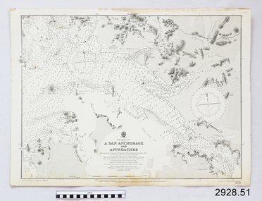
Document - Navigation Chart, A San Anchorage and Approaches
... Shipwreck-coast ...British Admiralty Navigation Chart - Korea - West Coast - A San Anchorage and Approacheswarrnambool, shipwrecked-coast, flagstaff-hill, flagstaff-hill-maritime-museum, maritime-museum, shipwreck-coast, flagstaff-hill-maritime-village, shipwrecked-artefact, navigation chart, british admiralty navigation chart, british admiralty, a san anchorage and approaches -
 Lakes Entrance Historical Society
Photograph - County Antrim, c1940
County Antrim was wrecked off coast of Lakes Entrance Victoria 12 January 1897 Later moved to Port AlbertBlack and white photograph of the figurehead from the County Antrim wrecked off coast, shows wooden figurehead in garden of Kalimna Hotel, where it had been placed as a garden feature soon after the wreck was abandoned. Lakes Entrance Victoriaships and shipping, shipwrecks, hotels -
 Ballarat Heritage Services
Digital photograph, Portland, Victoria, c2015
Colour photograph of the coast at Portland.portland, heritage, building, shops, main street, streetscape, townscape -
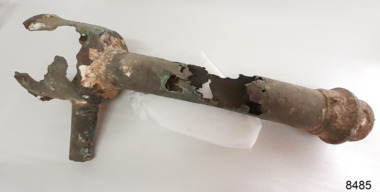 Flagstaff Hill Maritime Museum and Village
Functional object - Plumbing Fitting, Late 19th to early 20th century
The plumbing fitting has been recovered from the sea, as shown by the encrustations on its surface. The source of the fitting is unknown but i is likely to have been part of the fittings of a shipwreck, probably a urinal.The plumbing fitting is an example of a fitting from a ship, late 19th to early 20th century.Plumbing fitting, metal, from an unknown shipwreck. Top of fitting is bowl-shaped with a narrow inlet pipe. Wide pipe attaches to the centre of the bowl and to a threaded fitting at its base. There is a bar across the inside of the threaded fitting and a bolt joined to the bar's centre.flagstaff hill maritime museum and village, shipwreck artefact, great ocean road, flagstaff maritime museum, plumbing, ship's plumbing, urinal -
 Lakes Entrance Historical Society
Book, Reinelt W H, Wreck of the Monumental City, 1979
Monument to a Shipwreck in 1853 in Victorian waters near Mallacootashipwrecks -
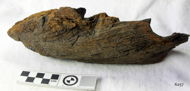 Flagstaff Hill Maritime Museum and Village
Wood Sample, 1854
... shipwreck-coast ...This timber fragment is from the shipwreck of the SCHOMBERG (1855). The bow of the ship broke off after an unsuccessful salvage attempt to tow her off the Peterborough reef. At the wreck-site the submerged hull points north towards the beach but the front section is missing. Parts of the bow have been carried away by the eastward bearing ocean currents and have come ashore on the western coast of New Zealand’s South Island. Don Charlwood writes in Wrecks & Reputations (1977) that in 1871 “a piece of wreckage over 20 feet long and 12 feet wide was brought out” by land from its remote location at Tauperika Creek. In 1875 “an even larger section was brought out by sea”. It was suggested at the time that these relics of a large wooden sailing ship were from the wreck of the SCHOMBERG some 20 years earlier on the Victorian coast. “To corroborate the theory”, Charlwood continues, “a piece was sent to Halls of Aberdeen [the ship’s builders in Scotland]. They identified it as having come from the ship they had launched with such pride in 1852.” Charlwood, whose great-grandparents were passengers on the SCHOMBERG’s fateful maiden voyage, acquired some samples of the wreckage timber recovered in New Zealand, and brought them back with him to Australia. In 1976 “comparison was made of timbers from the New Zealand find and timber from the remains of the hull at Peterborough. They proved to be from the same ship.” The extraordinary journey of these pieces of wood from the once mighty clipper ship SCHOMBERG came to an end in 1984, when they were given to Flagstaff Hill by the author, and reunited with other shipwreck timbers and copper bolts from the vessel that are on display at the Maritime Village. The shipwreck of the SCHOMBERG is of State significance - Victorian Heritage Register S612The artefact is a small piece of wood that was broken from the timbers of the shipwreck of the SCHOMBERG (1855) and carried by the eastern currents to New Zealand (1875). It has 2 drilled holes that show faint screw marks and no metallic residue (possibly for patent treenails). The top surface is rounded, of a dark colour, and showing clear grains that have been worn smooth by the action of the sea. There is a reddish stain on the timber where breakage has occurred. The wood appears to have been strong in its original condition but is now light to lift and soft and crumbly at its exposed edges. The artefact is in fragile condition.flagstaff hill, warrnambool, shipwrecked-coast, flagstaff-hill, flagstaff-hill-maritime-museum, maritime-museum, shipwreck-coast, flagstaff-hill-maritime-village, schomberg, shipwreck timber, don charlwood, ‘wrecks & reputations’ -
Glenelg Shire Council Cultural Collection
Domestic object - Plastic Drink Bottle - Portland Coast Water, n.d
Portland Coast Water plastic drink bottle, opaque, blue lid, Portland Coast Water logo back and front.Front: Side: metric scale from 100-400mls - embossed Back: Base: Bottles of Australia - Logo) Made in Australia ) embossedportland coast water -
 Warrnambool and District Historical Society Inc.
Booklet - Warrnambool Visitor's Handbooks 1979-2024, Collett, Bain and Gaspar, Printers, 1979-2014
This is a collection of eight Warrnambool Visitor handbooks produced between 1979 and 2014 by the City of Warrnambool Tourist Information Centre. They contain maps of Warrnambool, lists of services, accommodation and tourist attractions as well as many advertisements for local businesses.These handbooks give a useful snapshot of businesses and tourist attractions in Warrnambool for each of the years covered. (1979, 1980, 1986, 1990, 1993, 1994, 1995, 2014)[.1a] A 48 page booklet with white pages and blue printing. The front cover has a coloured photograph of Flagstaff Hill with boats on a man made lake in the foreground looking across Lake Pertobe toward South Warrnambool. [.1b] A coloured bifold brochure. The front cover has a fisherman on a cray-boat holding a crayfish in the lower section. The top quarter has a blue back ground with white printing. The rear cover is red and has small photos of the Hopkins River and the Framlingham Forest. [.2] A 48 page booklet with white pages and black printing. The front cover is white with black writing on the left hand side and a colour photograph of the Loch Ard peacock. The Warrnambool Premier Town stylised logo of seven Norfollk pines above blue waves is in the top right hand corner. There is a blank ink Warrnambool Library stamp underneath the logo. The rear cover has photographs of The Twelve Apostles and the Hopkins Falls and the Premier Town Logo [.3] A 40 page booklet with mainly black printing on white paper. There are three fold out maps of Warrnambool and the surrounding district. The glossy cover has a black background with a colour photograph of the Twelve Apostles taken at sunset. The rear cover has three small of Proudfoot's boathouse on the Hopkins River, Flagstaff Hill, and the main beach area. The front cover has black writing inside to peach coloured rectangles. The inside rear cover has a fold out coloured tour map of Western Victoria. [.4] A 40 page booklet printed on glossy white paper with coloured photographs and black and red printing. The front cover has a photograph of The Twelve Apostles surrounded by a white border. There is red writing in the upper border. There is a sandy coloured writing superimposed across the bottom of the photograph and a Victoria's Shipwreck Coast logo in the bottom right hand corner. [.5] A 44 page booklet printed on white paper with black printing. The cream coloured cover has a pale red rectangle with blue writing on the right hand facing edge and includes two stylised Norfolk pines and with waves underneath. There is is an intersecting blue rectangle with cream printing. [.6] A 48 page booklet printed on white paper with black printing. The cover is brown with a cream vertical strip containing black writing on the right hand side. There is a stylised map from Geelong to Mount Gambier showing the Great Ocean Road across the cover. [.7] A 48 page booklet printed on white paper with black print. The glossy colour cover has a photograph of a Southern Right whale fluke. There is white printing on a the blue background of the sky and sea. The bottom left hand side of the front cover has a Tourism Victoria logo made of jigsaw puzzle pieces. The back cover has a stylised coloured map of The Great Ocean Road located in a white rectangle at the top of the page. Within the rectangle is a small map of Australia locating Victoria and the part of Victoria covered by the map. [.8] A 64 page A5 coloured booklet printed on white pages with black print. The white front cover has black and grey print with a colour photograph of two people holding coffee cups watching four race horses being exercised on the beach and in the water of Lady Bay in the early morning. The bottom right hand corner has a Tourism Victoria logo. The rear cover has a mainly blue back ground with a pink orange and green colour splats contains words advertising the 2015 Fun 4 Kids Festival [.1a] Warrnambool The Heart of Victoria's Great Southwest Visitor's Handbook [.1b] Warrnambool City for all seasons; The Heart of Victoria's Great Southwest [.2] Warrnambool visitor's handbook Warrnambool Premier Town 1979-1982 [.3] Warrnambool Handbook Victoria [.4] Warrnambool The Shipwreck Coast [.5] Welcome to Warrnambool Warrnambool Visitors Handbook 1993-1994 [.6] Welcome to Warrnambool Visitors Handbook 1994-95 Rear cover: Warrnambool Centre of Victoria's Shipwreck Coast on Australia's Great Ocean Road [.7] Warrnambool Shipwreck Coast - Great Ocean Road; You'll love every piece of Victoria; Visitors Handbook [.8] Warrnambool Great Ocean Road Official Visitor Guide; It's a wonderful Warrnambool; You'll love every piece of Victoria visitvictoria.com. Rear Cover Live entertainment.Workshops.Creativity.Action 28 June - 5 July 2015 Australia's Best Children's Festival F4K The ultimate winter school holiday adventure Fun 4 kids festival Warrnambool For more information visit Fun4kids.com.au Warrnambool great Ocean Road Victoriawarrnambool, visitor handbooks, tourist information guides, warrnambool maps -
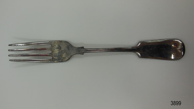 Flagstaff Hill Maritime Museum and Village
Domestic object - Fork, c. 1878
This fork was recovered from the wreck of the Loch Ard. It is the Old English design that has been very popular since the 19th century. It has been restored to resemble its original state prior to the disaster in 1878. The for was originally plated with silver, which is when a base metal such as nickel or nickel alloy with copper and/or zinc has been plated or coated with a thin layer of silver. Wear on the metal will cause the base metals to appear through the silver plating. Some manufacturers gave a warranty that the cutlery was ‘white throughout’ but didn’t necessarily say it was solid silver. LOCH ARD 1873-1878 – The Scottish-built clipper ship Loch Ard was bound for Melbourne in 1878 with 54 people on board. The mixed cargo it carried included items for the 1880 International Exhibition in Melbourne, one of which was the now famous Majorca ware Minton ‘Peacock’ statue. The Loch Ard was wrecked on June 1st when the ship crashed into Mutton Bird Island, east of Port Campbell. The only survivors were Tom Pearce, a crew member, and Eva Carmichael, a young passenger who was rescued by Pearce. The Gibsons, owners of nearby Glenample Homestead, cared for Tom, and for Eva who stayed longer before returning to Ireland. The wreck of the Loch Ard was discovered in 1967, before the introduction of the Victorian historic shipwreck legislation. In 1969 it was decided that all recovered material should be lodged with the Receiver of Wrecks. In 1980 Flagstaff Hill Maritime Museum Divers received a permit to recover artefacts from the wreck to safeguard them from looters. In 1982 the site was listed as a Historic Shipwreck, and the Maritime Archaeology Unit recovered loose artefact material. The fork is recognised as being historically significant as an example of cutlery either as part of the flatware service of the ship ‘Loch Ard’ or part of the ship’s cargo, imported for use in Colonial Victoria in the 19th to early 20th century. Flagstaff Hill’s collection of artefacts from LOCH ARD is significant for being one of the largest collections of artefacts from this shipwreck in Victoria. It is significant for its association with the shipwreck, which is on the Victorian Heritage Register (VHR S417). The collection is significant because of the relationship between the objects, as together they have a high potential to interpret the story of the LOCH ARD. The LOCH ARD collection is archaeologically significant as the remains of a large international passenger and cargo ship. The LOCH ARD collection is historically significant for representing aspects of Victoria’s shipping history and its potential to interpret sub-theme 1.5 of Victoria’s Framework of Historical Themes (living with natural processes). The collection is also historically significant for its association with the LOCH ARD, which was one of the worst and best known shipwrecks in Victoria’s history. Fork; silver plated. The fork is the Old English design and is embossed with several marks. it has recently been restored. Shipwreck artefact from the Loch Ard. 3 letters within an oval (- - S) 4 letters within circles (E) (P) (N) (S) 1 letter within a shield appears to be a [B] flagstaff hill, warrnambool, shipwrecked coast, flagstaff hill maritime museum, maritime museum, shipwreck coast, flagstaff hill maritime village, great ocean road, shipwreck artefact, loch ard, victoria, eva carmichael, tom pearce, cutlery, silver flatware, silver plate, antique, old english flatware pattern, eating utensil, fork, silverware, dining utensil -
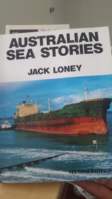 Peterborough History Group
Australian Sea Stories Book by Jack Loney, Australian Sea Stories, Published 1985, reprinted 1989
covers lesser known shipwrecks, mysteries and adventures of the Australian coast.149 page soft cover book by Jack Loney; with a list of Contents and index of ship names and surnames.loney, jack; -
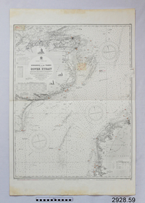 Flagstaff Hill Maritime Museum and Village
Document - Navigation Chart, Dungeness to the Thames and the Dover Strait
... shipwreck-coast ...British Admiralty Navigation Chart - England - South Coast - Dungeness to the Thames and the Dover Straitwarrnambool, shipwrecked-coast, flagstaff-hill, flagstaff-hill-maritime-museum, maritime-museum, shipwreck-coast, flagstaff-hill-maritime-village, shipwrecked-artefact, navigation chart, british admiralty navigation chart, british admiralty, dungeness to the thames, dover strait -
 Phillip Island and District Historical Society Inc.
Photograph, Bryant West
One of a collection of over 400 photographs in an album commenced in 1960 and presented to the Phillip Island & Westernport Historical Society by the Shire of Phillip IslandPhotograph of Rocky south coast shoreline.local history, photography, photographs, coastline, phillip island, southern coastline phillip island, john jenner, bryant west -
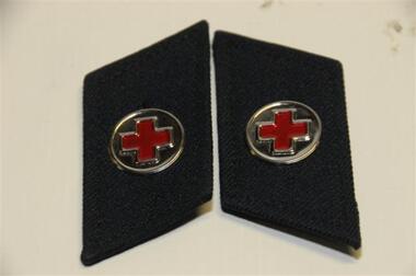 Running Rabbits Military Museum operated by the Upwey Belgrave RSL Sub Branch
Epaulettes
Epaulettes N.V.A. Coast Guard Medicuniform, vietnam -
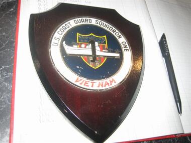 Running Rabbits Military Museum operated by the Upwey Belgrave RSL Sub Branch
Plaque
US Coast Guard Sqd Oneplaque -
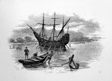 Ballarat Heritage Services
Image, Anchored Ship
First Published in Picturesque Atlas of Australia.Line drawing of a ship anchored on the coast.ship, exploration, immigration -
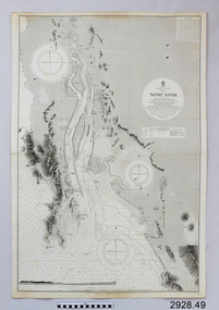 Flagstaff Hill Maritime Museum and Village
Document - Navigation Chart, Tavoy River
... Shipwreck-coast ...British Admiralty Navigation Chart - Bay of Bexgal - East Coast - Bruma - Tavoy Riverwarrnambool, shipwrecked-coast, flagstaff-hill, flagstaff-hill-maritime-museum, maritime-museum, shipwreck-coast, flagstaff-hill-maritime-village, shipwrecked-artefact, navigation chart, british admiralty navigation chart, british admiralty, tavoy river, bay of bexgal, bruma -
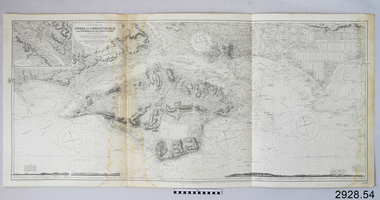 Flagstaff Hill Maritime Museum and Village
Document - Navigation Chart, Owers to Christchurch with Spithead and the Isle of Wight
... Shipwreck-coast ...British Admiralty Navigation Chart - England - South Coast - Owers to Christchurch with Spithead and the Isle of Wightwarrnambool, shipwrecked-coast, flagstaff-hill, flagstaff-hill-maritime-museum, maritime-museum, shipwreck-coast, flagstaff-hill-maritime-village, shipwrecked-artefact, navigation chart, british admiralty navigation chart, british admiralty, owers to christchurch -
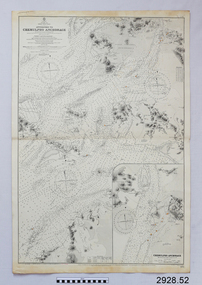 Flagstaff Hill Maritime Museum and Village
Document - Navigation Chart, Approaches to Chemulpho Anchorage
... Shipwreck-coast ...British Admiralty Navigation Chart - Yellow Sea - Korea East Coast - Approaches to Chemulpho Anchoragewarrnambool, shipwrecked-coast, flagstaff-hill, flagstaff-hill-maritime-museum, maritime-museum, shipwreck-coast, flagstaff-hill-maritime-village, shipwrecked-artefact, navigation chart, british admiralty navigation chart, british admiralty, approaches to chemulpho anchorage, korea -
 Ballarat Heritage Services
Photograph - Image - Black and White, Portsea on Port Phillip Bay, c1950, c1950
A black and white image of the coast at Portsea, Victoria.beach, portsea, port phillip bay -
Hand Tool Preservation Association of Australia Inc
Photographs
This item is part of the Thomas Caine Tool Collection, owned by The National Trust of Australia (Victoria) and curated by the Hand Tools Preservation Association of Australia.7 photos, jetty - ship - coast scenes -
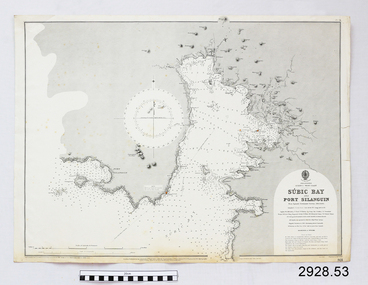 Flagstaff Hill Maritime Museum and Village
Document - Navigation Chart, Sùbic Bay and Port Silanguin
... Shipwreck-coast ...British Admiralty Navigation Chart - Phillipines - Luzom I. - West Coast - Sùbic Bay and Port Silanguinwarrnambool, shipwrecked-coast, flagstaff-hill, flagstaff-hill-maritime-museum, maritime-museum, shipwreck-coast, flagstaff-hill-maritime-village, shipwrecked-artefact, navigation chart, british admiralty navigation chart, british admiralty, phillipines, sùbic bay and port silanguin -
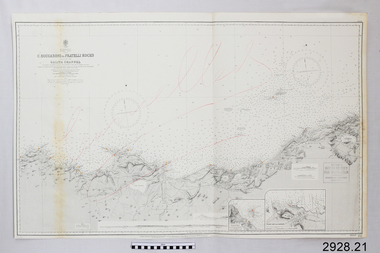 Flagstaff Hill Maritime Museum and Village
Document - Navigation Chart, C. Bougaroni to Fratelli Rocks including the Galita Channel
... shipwreck-coast ...British Admiralty Navigation Chart - Africa, North Coast - C. Bougaroni to Fratelli Rocks and including The Galita Channelwarrnambool, shipwrecked-coast, flagstaff-hill, flagstaff-hill-maritime-museum, maritime-museum, shipwreck-coast, flagstaff-hill-maritime-village, shipwrecked-artefact, british admiralty navigation chart, navigation chart, c. bougaroni to fratelli rocks including the galita channel -
 Phillip Island and District Historical Society Inc.
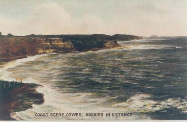
Photograph, Early 20th Century
One of a collection of photographs donated by Bruce BennettColoured copy of a postcard showing the coastal cliffs on Westernport with The Nobbies in the distance"Coast Scene, Cowes, Nobbies in Distance."phillip island coastline, cliffs and shoreline westernport, bruce bennett -
 National Wool Museum
Pennant
Queensland's GOLD COAST FUN IN THE SUNgold coast, queensland -
 Flagstaff Hill Maritime Museum and Village
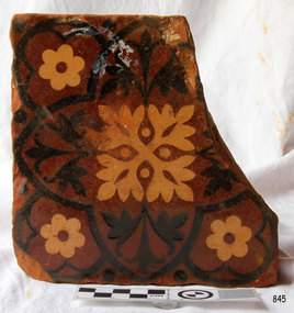
Ceramic - Tile, circa 1878
This Minton floor tile is from the wreck of the LOCH ARD along with other examples of this manufacture recovered from the wreck site and form part of the collection at Flagstaff Hill. The iron-hulled clipper ship from the Loch Line was heading for Port Phillip from London when it ran into the cliffs of Mutton Bird Island near Port Campbell and was wrecked on June 1st, 1878. The LOCH ARD was laden with high-value cargo including luxury goods intended for display at the Melbourne International Exhibition in 1880. One notable survivor from the ship’s freight manifest was the well-packed Minton porcelain peacock, a two-metre-high ceramic masterpiece of vivid glazed colours. The almost total loss of life and property from the LOCH ARD registered as a shocking tragedy for the Colony of Victoria, at a time when social confidence and economic optimism were otherwise high. The wealth generated from Gold and Wool was increasingly being spent on grandiose private residences and imposing public buildings. The demand for quality furnishings and fittings was therefore strong. Among the products consigned to burgeoning colonial markets by the Milton Pottery at Stoke upon Trent, were their new range of colourfully patterned but very durable floor tiles – ideal for the high-traffic spaces in the large civic buildings then being constructed in Australia and America. These new floor tiles were “encaustic”, meaning that their designs and colours were encased “within” the depth of the tile. Rather than their decorative patterns being glazed onto the surface of the tile, their inlaid designs were created during the manufacturing process, as “coloured slips” (or liquid clay) were poured into a deep pre-moulded casting. When fired, the resulting tile was colour-fast and design-fast. A brief history of the Loch Ard (1873-1878): - The sailing ship Loch Ard was one of the famous Loch Line ships that sailed from England to Australia. Barclay, Curdle and Co. built the three-masted iron vessel in Glasgow in 1873. It had sailed three trips to Australia and one trip to Calcutta before its fateful voyage. Loch Ard left England on March 2, 1878, under the command of recently married, 29-year-old Captain Gibbs. It was bound for Melbourne with a crew of 37, plus 17 passengers. The general cargo reflected the affluence of Melbourne at the time. Onboard were straw hats, umbrellas, perfumes, clay pipes, pianos, clocks, confectionery, linen and candles, and a heavier load of railway irons, cement, lead and copper. Other cargo included items intended for display in the Melbourne International Exhibition of 1880. The Loch Ard had been sailing for three months and was close to its destination on June 1, 1878. Captain Gibbs had expected to see land at about 3 am but the Loch Ard ran into a fog that greatly reduced visibility and there was no sign of land or the Cape Otway lighthouse. The fog lifted at 4 am and the sheer cliffs of Victoria's west coast were much closer to them than Captain Gibbs expected. He tried to manage the vessel but failed and the ship struck a reef at the base of Mutton Bird Island, near Port Campbell. The top deck loosened from the hull, and the masts and rigging crashed down, knocking passengers and crew overboard. The lifeboat was launched by Tom Pearce but crashed into the side of Loch Ard and capsized. He clung onto its overturned hull and sheltered under it. He drifted out to sea and the tide brought him back to what is now called Loch Ard Gorge. He swam to shore and found a cave for shelter. A passenger, Eva Carmichael, had raced onto the deck to find out what was happening and was confronted by towering cliffs above the ship. She was soon swept off the ship by a huge wave. Eva saw Tom Pearce on a small rocky beach and yelled to attract his attention. He swam out and dragged her to the shelter of the cave. He revived her with a bottle of brandy from a case that had washed up on the beach. Tom scaled a cliff in search of help and followed some horse hoof prints. He came from two men from Glenample Station, three and a half miles away. He told the men of the tragedy and then returned to the gorge while the two men rode back to the station to get help. They reached Loch Ard Gorge and took the two shipwreck survivors to Glenample Station to recover. Eva stayed at the station for six weeks before returning to Ireland by steamship. In Melbourne, Tom Pearce received a hero's welcome and was presented with a medal and some money. Of the 54 crew members and passengers on board, only two survived: the apprentice, Tom Pearce and the young woman passenger, Eva Carmichael, who lost her family in the tragedy. One of the most unlikely pieces of cargo to have survived the shipwreck was a Minton porcelain peacock - one of only nine in the world. The peacock was destined for the Melbourne International Exhibition in 1880. It had been well packed, which gave it adequate protection during the violent storm. Today, the Minton peacock can be seen at the Flagstaff Hill Maritime Museum in Warrnambool. From Australia's most dramatic shipwreck, it has now become Australia's most valuable shipwreck artefact and is one of very few 'objects' on the Victorian State Heritage Register. The Minton floor tile is significant for its hard-wearing yet attractive design. The shipwreck of the LOCH ARD is of State significance. Victorian Heritage Register S417. Flagstaff Hill’s collection of artefacts from LOCH ARD is significant for being one of the largest collections of artefacts from this shipwreck in Victoria. It is significant for its association with the shipwreck, which is on the Victorian Heritage Register (VHR S417). The collection is significant because of the relationship between the objects, as together they have a high potential to interpret the story of the LOCH ARD. The LOCH ARD collection is archaeologically significant as the remains of a large international passenger and cargo ship. The LOCH ARD collection is historically significant for representing aspects of Victoria’s shipping history and its potential to interpret sub-theme 1.5 of Victoria’s Framework of Historical Themes (living with natural processes). The collection is also historically significant for its association with the LOCH ARD, which was one of the worst and best-known shipwrecks in Victoria’s history. A square Minton floor tile with a black and apricot pattern against a chocolate brown background. There is a large chip missing. This decorative floor tile was recovered from the shipwreck of the LOCH ARD. On the back, or base, of the tile is inscribed the number “46” and the letters “Minton & Co Patent Stoke upon Trent”.flagstaff hill, warrnambool, shipwrecked coast, flagstaff hill maritime museum, maritime museum, shipwreck coast, flagstaff hill maritime village, great ocean road, loch line, loch ard, captain gibbs, eva carmichael, tom pearce, glenample station, mutton bird island, loch ard gorge, encaustic tile, melbourne international exhibition, floor tile, minton floor tile -
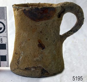 Flagstaff Hill Maritime Museum and Village
Domestic object - Tankard
Metal tankards often come with a glass-bottom. There is a legend that the glass-bottomed tankard was developed as a way of refusing the King's shilling, i.e. conscription into the British army or navy. The drinker could see the coin in the bottom of the glass and refuse the drink, thereby avoiding conscription. However, this is likely to be a myth, for the Navy could use force by using “press gangs” to conscript recruits rendering this type of deception unnecessary. Other legends are that in a bar fight, a recipient with a glass bottom tankard could see if a first punch was thrown whilst they had the tankard raised to drink. Another has it that the glass bottom was implemented so the drinker while drinking could observe his surroundings and the dubious people within the Tavern such as thieves, ladies of the night or anyone that could, or may do him harm. A further story is that the glass bottom merely allowed the drinker to judge the clarity of their drink while forgoing the expense of using a fragile and expensive pint glass. If this item is an early tankard from the 18th or 19th century it would be a significant item. Also if a known maker from these time periods could be established it would make the tankard quite valuable. Tankards from this time are snapshots of peoples past everyday lives and form a significant part of our social history so are worthy of preservation in all there forms. Pewter tankard with glass bottom, marine encrusted, recovered from unknown shipwreck.tankard, pewter, mug, flagstaff hill, warrnambool, shipwrecked coast, flagstaff hill maritime museum, maritime museum, shipwreck coast, flagstaff hill maritime village, great ocean road, vessel, drink, tavern, drinkware, kings shilling -
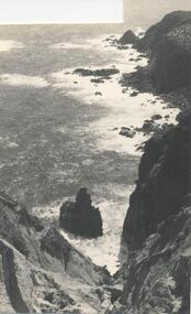
 Phillip Island and District Historical Society Inc.
Photograph, Unknown
One of 6 photographs donated by M. BattyBlack & White photograph of the South Coast of Phillip Island.phillip island coastline, south coast phillip island, phillip island, m batty