Showing 67512 items
matching shire-of-orbost
-
 Lakes Entrance Historical Society
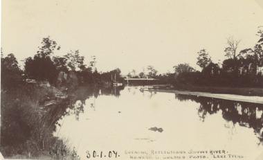
Postcard - Snowy River bridge, H D Bulmer Lake Tyers, Orbost Victoria, 1905 c
Black and white postcard taken of Snowy River with bridge in distance at Orbost VictoriaEvening Reflections Snowy Riverwaterways, bridges, rivers -
 Lakes Entrance Historical Society
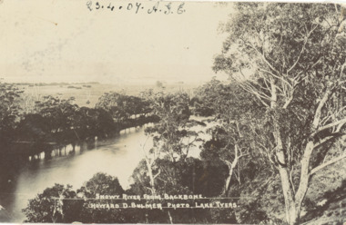
Postcard - Snowy River showing Backbone Point, H D Bulmer, Orbost Victoria, 1905 c
Black and white postcard of Snowy River showing Backbone point Orbost VictoriaSnowy River from Backbonerivers, topography -
 Lakes Entrance Historical Society
Postcard - Brodribb River Bridge, Sherwood, Orbost, 1907 c
Black and white postcard of the bridge over the Brodribb River near Orbost VictoriaBrodribb River 6.4.07waterways, bridges, topography -
 Greensborough Historical Society
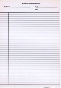
Form, Shire of Diamond Valley, Shire of Diamond Valley: Inter-office memo, 1990_
... Shire of Diamond Valley: Inter-office memo...Shire of Diamond Valley ...Inter-office memo pad from Shire of Diamond Valley.Inter-office memo: 2 copies on padshire of diamond valley -
![Sign, Shire of Eltham, St Faiths Road, Shire of Eltham [street sign], 1960s](/media/collectors/4f729f5697f83e03086015b8/items/67db6caab13536720ddc4bb9/item-media/67f21a5be76666667ba86b1f/item-fit-380x285.jpg) Greensborough Historical Society
Greensborough Historical SocietySign, Shire of Eltham, St Faiths Road, Shire of Eltham [street sign], 1960s
... St Faiths Road, Shire of Eltham [street sign]...Shire of Eltham ...Road sign pre 1994 of St Faiths Road, Montmorency, formerly in the Shire of Eltham. This early sign does not have the Shire of Eltham 'branding' of later signs. Following the redistribution of local government areas in 1994, St Faiths Road was allocated to the City of Banyule.Double Sided Metal sign, white with black writing shire of eltham, road sign, st faiths road montmorency -
 Eltham District Historical Society Inc
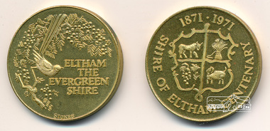
Medallion, Shire of Eltham, Medallion, Shire of Eltham Centenary 1871-1971, 1971
... Medallion, Shire of Eltham Centenary 1871-1971...Shire of Eltham ...The medallion was issued to all ratepayers in celebration of the Shire of Eltham's Centenary in 1971Gold coloured medallion approx 2.5 cm diameter in a clear plastic sleeveshire of eltham, shire of eltham centenary, medallion -
 Greensborough Historical Society
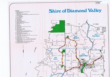
Map, Map - Shire of Diamond Valley, 1990c
... Map - Shire of Diamond Valley...Shire of Diamond Valley ...Map issued by the Shire of Diamond Valley showing location of key organisations and features Map printed in colour, one sideshire of diamond valley -
 Orbost & District Historical Society
minute book, 24.8.1884 - 19.11.1926
A Mechanics’ Institute hall was constructed in 1885 and opened as Orbost's first library. It was situated in Browning Street, Orbost. The hall is still in use today as a community venue. Mechanics' Institutes are the forerunners of public libraries and adult education in Australia. The origin of mechanics' institutes is attributed to Dr George Birkbeck, who in 1799 gave a series of free lectures for the working men of Glasgow. At the time, 'mechanic' meant artisan, tradesman or working man. The movement spread quickly throughout the British Empire. The first Victorian Mechanics' Institute was the Melbourne Mechanics' Institute established in 1839. From the 1850s, Mechanics' Institutes quickly spread throughout Victoria wherever a hall or library, or a school was needed. This ledger was used by the Orbost Mechanics' Institute from 1884 until 1926. The item was donated to Orbost & District Historical society from P.R.O.V. as a Place of Deposit (POD) item for safe keeping by a local history group or museum.The Mechanics' Institute was a very early feature of the Orbost community. The building became a community facility used for a variety of essential civic needs in particular a library. It also provided a suitable venue for community social requirements and functions.A heavy minute book with faded black covers and brown binding. The edges of the pages are marbled as are the end covers. Pages inside are blue with hand-written black ink records. It contains minutes from the Orbost Mechanics Institute.on spine on red leather in gold lettering: "MINUTE BOOK"minute-book orbost-mechanics'-institute -
 Tatura Irrigation & Wartime Camps Museum
stationery, Shire of Rodney stationery
... Shire of Rodney stationery ...Shire of Rodney stationery 1886 - 1997Two sheets of Shire of Rodney stationery (A4), including Shire logo, Phone No 2, Box No 13. two copies, pre 1925Shire of Rodney 1886 - 1997shire of rodney, official stationery, council stationery -
 Greensborough Historical Society
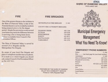
Pamphlet, Municipal Emergency Management: what you need to know: Shire of Diamond Valley, 1990c
... : Shire of Diamond Valley...Shire of Diamond Valley ...Shire of Diamond Valley Municipal Emergency Management pamphlet with emergency phone numbers and procedures. Circa 1990s.Pamphlet 2 sided printed on cream paper, text only.shire of diamond vallety, emergency services -
 Orbost & District Historical Society
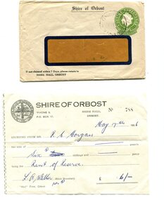
envelope and receipt, Snowy River Mail as "Mail" Print, May 17 1956
This receipt was issued to R. C. Morgan of Orbost. on May 17, 1956. It was for rent of reserve for six shillings. It was issued by the Orbost Shire Council. The Shire of Orbost was a local government area about 380 kilometres east of Melbourne, the state capital of Victoria, Australia. The shire covered an area of 9,347 square kilometres and existed from 1892 until 1994. Originally, Orbost was part of the Bairnsdale Road District which was created on 30 April 1867. Splitting away as part of the Shire of Tambo in 1882, Orbost was first incorporated as a shire in its own right as the Shire of Croajingolong on 30 May 1892. It received its present name on 17 February 1893. On 3 January 1913 part of its western riding was annexed to Tambo as its Cunninghame Riding. Local governments play an important role in the lives of citizens in Australia. Local government authorities exist to provide services and amenities to local communities, and are also responsible for regulating and providing services for land and property in their district. This item is representative of a time when Orbost had its own Shire Council. A widow - faced envelope with a green threepence stamp top right corner. At the top is "Shire of Orbost". Bottom right is "If not claimed within 7 Days please return to SHIRE HALL, ORBOST".There is a receipt to R.C. Morgan for 6/- being for the "rent of reserve" and signed by L.A. Walker. It has the Orbost Shire logo in the top left corner.orbost-shire-council morgan-r.c. -
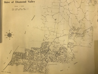 Greensborough Historical Society
Map, Shire of Diamond Valley, 1964-1994
... Shire of Diamond Valley...Shire of Diamond Valley ...Map of the former Shire of Diamond Valley, 1964-1994, showing the local government area from Greensborough to Hurstbridge.Map on yellowed paper.shire of diamond valley, greensborough, hurstbridge -
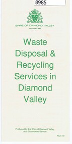 Greensborough Historical Society
Pamphlet - Pamphlet and document, Shire of Diamond Valley, Waste Disposal & Recycling Services in Diamond Valley, 01/02/1992
... Shire of Diamond Valley, Waste Disposal & Recycling...Shire of Diamond Valley ...Shire of Diamond Valley Pamphlet and letter to Householders regarding the Kerbside Recycling Collection Services being implemented in 1993.Pamphlet, folder printed in green on buff paper; Letter to Householders, black text on white paper.shire of diamond vallety, recycling, waste management -
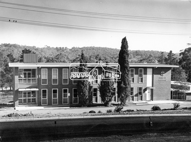 Eltham District Historical Society Inc
Photograph, Eltham Shire Office, shortly after duplication of Main Road, c.1968
... Eltham Shire Office, shortly after duplication of Main Road...Shire of Eltham ...Eltham Shire Council office built 1964 on the former site of Shillinglaw Cottage. In 1971 the offices were extended with a southern wing (to the left of the building) which housed the Eltham Library and planning offices. Taken shortly after widening of Main Road between Pitt Street and Elsa Court which was undertaken between February 1968 and August 1968. Image was most probably commissioned by Eltham Shire Council and taken by Hugh Fisher, photographer who operated from premises between Arthur and Dudely streets and was often contracted by the shire for official photographic work. The image was used in the August 1971 issue of Australian Municipal Journal This photo forms part of a collection of photographs gathered by the Shire of Eltham for their centenary project book,"Pioneers and Painters: 100 years of the Shire of Eltham" by Alan Marshall (1971). The collection of over 500 images is held in partnership between Eltham District Historical Society and Yarra Plenty Regional Library (Eltham Library) and is now formally known as the 'Shire of Eltham Pioneers Photograph Collection'. It is significant in being the first community sourced collection representing the places and people of the Shire's first one hundred years.Digital image and 120 format B&W negativesepp, shire of eltham pioneers photograph collection, eltham, main road, duplication, road widening, shillinglaw trees, local government -
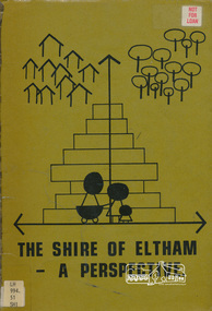 Eltham District Historical Society Inc
Book, Shire of Eltham, The Shire of Eltham - A Perspective, July 1981
... The Shire of Eltham - A Perspective...Shire of Eltham ...This report was produced by the Shire of Eltham (Planning Department) following a population study of the Shire. It also includes other areas of general interest. The Document contents includes Present and Future - Population - Housing - Residential Lands - Social Characteristics - Development and History. Includes maps, tables and diagrams. Part 1: The Existing situation - introduction, the Shire of Eltham, physical characteristics, historical development, population growth. Characteristics of the population - size and distribution, age / sex, natural increase, migration. Socio-Economic Factors: socio-economic status, employment/workforce, education, other social factors. Housing/ building statistics: characteristics of Housing stock, current residential trends, other types of building activity. Residential Land: existing vacant lots, estimated additional lots. Part 2: The Future. Land availability, the future population.The Shire of Eltham Council resolved on publication of this report "to commend it to the ratepayers as a most valuable resource document". It provides a comprehensive statistical review of the Shire of Eltham, Victoria in 1981 with some population and development predictions for the future.Spiral bound, soft cover, includes indexBarcode and identification markings including stamped "WITHDRAWN" from Heidelberg Regional Library Serviceshire of eltham, planning, population -
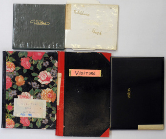 Orbost & District Historical Society
visitor books, 1987 -1989
These books were used at the Slab Hut (Orbost Visitor Information Centre) as visitor sign in books. Orbost. This slab hut was built in 1872 as a family dwelling on a site about 3 km upstream from the junction of the Buchan and Snowy Rivers about 40 kms from Orbost on the Yalmy Rd. No nails were used in the construction; it was all wired together. After a period in storage the slab hut was opened in its present location in Orbost as the Information Centre in 1987. The Slab Hut is an Orbost icon.Five books used by the Slab Hut (Orbost Visitor Information Centre) as visitor sign in books. 2467.1 has a green cover with "Visitors" in gold print and is dated 28.3.87 - 6.7.87. 2467.2 has a black cover with a gold border and "Visitors" in gold print. It is dated 11.6.87 - 3.11.89. 2467.3 has a black cover with red corners and spine. 2467.4 has pink and red flowers on a black background and is dated Sept 93 - 9.3.98. 2467.5 is a Children's Visitor Book and has a white cover with gold print. It is dated 9.4.87 -23.7.89. All contain handwritten comments, details of visitors to the Orbost Visitor Information Centre.2467.1 - Inside front cover - OFFICIALLY OPENED 28.3.1987 by VIC. GOVERNOR DAVIS McCAUGHEY 2467.2 - label on spine - VISITOR BOOK 2 inside a circle. 2467.3 - label on front - VISITORS ; label on spine - dates Feb 89 - Sep 93 2467.4 - label on front - VISITOR'S BOOK Sept 93 -9.3.98 tourissm slab-hut orbost-visitor-information-centre -
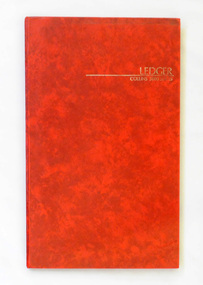 Orbost & District Historical Society
ledger, November 1971
Orbost Aero Club began in 1969 with Basil Dowie as Chair, David Nixon as Secretary/Treasurer. The group went into recess from 1977-1991 closing in 1997. The mid 1960s were boom years in flying training in Australia and the number of Aero Clubs grew rapidly. The Club played a significant role in the establishment of the small airport at Marlo and in the ongoing operation and development of the airport over the years particularly for patient transfer by aerial ambulance. The Orbost Aero Club Club played a significant role in the establishment of the small airport at Marlo and in the ongoing operation and development of the airport over the years.A red covered ledger book of hand-written membership records for the Orbost Aero Club. It is alphabetically indexed. The book is a Collins 3880 Series Ledger.orbost-aero-club -
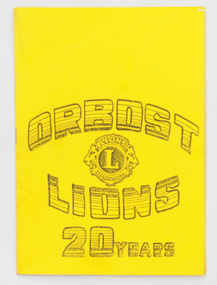 Orbost & District Historical Society
program, Orbost Lions Club, 1989
Orbost Lions Club was established in 1969. The first president was Don McKenzie. David Nixon was a director. In 1989 the president was Rom Konieczny. The club was formed to assist with local community fundraising for special causes. This program was produced to be used at the 20 Year Celebration held in 1989.The Lions Club of Orbost is a volunteer service club which contributes to the Orbost community. A program printed in black type on yellow paaper. It was used for the Orbost Lions Club 20 years celebration. It contains a program for the event, a list of 1969 and 1989 members as well as the Lions Charter.lions-orbost community -
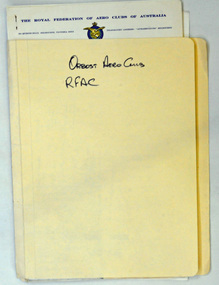 Orbost & District Historical Society
documents in folder, late 1960 - 1990's
The Royal Federation of Aero Clubs of Australia is the national body of Aero Clubs and other aviation associations. The prime objectives of the Federation are to foster aviation in Australia, to ensure adequate flying training is available to all pilots and to encourage national and local competitions, air races and other aviation events.(ref R.F.A.C. web site) Orbost Aero Club began in 1969 with Basil Dowie as Chair, David Nixon as Secretary/Treasurer. The group went into recess from 1977-1991 closing in 1997. The mid 1960s were boom years in flying training in Australia and the number of Aero Clubs grew rapidly. The Club played a significant role in the establishment of the small airport at Marlo and in the ongoing operation and development of the airport over the years particularly for patient transfer by aerial ambulance. The Orbost Aero Club Club played a significant role in the establishment of the small airport at Marlo and in the ongoing operation and development of the airport over the years.A cream coloured folder ( NORMAN BROS) containing documents pertaining to membership of the Royal Federation of Aero Clubs of Australia. It contains membership cards, receipts, correspondence, minutes, application forms for gold, silver and bronze seals.On front - Orbost Aero Club R F A Corbost-aero-club royal-federation-aero-clubs -
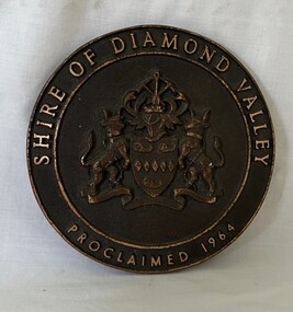 Greensborough Historical Society
Plaque, Shire of Diamond Valley, Shire of Diamond Valley, Proclaimed 1964 Plaque, 1960s
... Shire of Diamond Valley, Proclaimed 1964 Plaque...Shire of Diamond Valley ...This Logo was from the front door of the original Diamond Valley Library under Shire of Diamond Valley offices, Civic Ave, Greensborough. This was before the current Diamond Valley branch was built.Round brass plaque with writing and logoshire of diamond valley, plaques, diamond valley library -
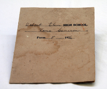 Orbost & District Historical Society
school report, 1936
Roma CAMERON was the daughter of Harry Purchase CAMERON and Lilian Gladys (nee HARDING). She was the youngest of three siblings: Jean (Mrs John Gavin (Jack) RALSTON) and James (Jim) (m. Joan HOSSACK). , Harry's father, James Cameron, came to Bellagoogan on Majors Creek in 1882. Bellagoogan was on Majors Creek near Orbost and was the site of the first race course. Like many others at the time, the Camerons bred race horses.Harry died in 1964 aged 75. Roma married Ronald Richard SMITH in 1944.Orbost High School / Orbost Secondary College has played a significant role in the education of senior students in the district. It is the sole institution for secondary education. This item is representative of its history. The Cameron families were early settlers in the Orbost area.A school report on card/paper for Roma Cameron, Form F at Orbost Elementary High School. It is dated 1936. Typewritten with handwritten entries.education orbost-elementary-high-school school-report cameron-roma -
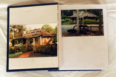 Orbost & District Historical Society
album, Orbost Visitor Information Centre, 1997
The original slab hut was built in 1872 as a family dwelling on a site about 3 km upstream from the junction of the Buchan and Snowy Rivers about 40 kms from Orbost on the Yalmy Rd. No nails were used in the construction; it was all wired together. After a period in storage the Slab Ht was opened in its present location in Orbost as the Information Centre in 1987. This album documents an important event in Orbost.A photo album with a navy blue cardboard cover with gold embossing on the front and spine. It contains 32 photos of the 1997 10 year anniversary celebration of the establishment of the Slab Hut - the Orbost Visitor Information Centre. It also contains 3 postcards and 2 fridge magnets.slab-hut album orbost -
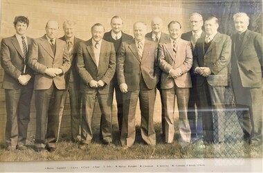 Pyrenees Shire Council
Photograph, Shire of Lexton Councillors, 1980
... Shire of Lexton Councillors ...Photograph of Shire of Lexton Councillors 1980 significant to the Pyrenees Shire and Lexton communityframed photograph of Shire of Lexton Councillors Inscribed front: Lexton Shire Councillors 1980 -
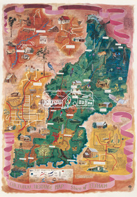 Eltham District Historical Society Inc
Map (item), Megan Evans, Cultural Heritage Map, Shire of Eltham, 1993
... Cultural Heritage Map, Shire of Eltham...Shire of Eltham ...Copy of artist's map of the Shire of Eltham with numerous historical and cultural places of interest illustrated and notated including evidence of original Wurundjeri occupation and local flora and fauna. The original watercolour is held in the Nillumbik Shire Council Civic Collection. "Evans remembers being surprised they had asked an artist to create this map rather than a designer. Originally made as a watercolour, the map was later made into posters and adorned many homes around the area. The map creatively interprets the town and provides a wayfinding to both cultural and historical points in the area." Nillumbik Arts News December 2023. artist, buildings, cultural heritage map, fauna, flora, map, megan evans, shire of eltham, wurundjeri -
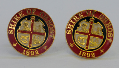 Orbost & District Historical Society
cuff links, 1992
This pair of cuff links was produced in 1992 as a memento/souvenir to commemorate the centenary of the formation of the Shire of Orbost - 1892-1992. Orbost was at first included in the Bairnsdale Shire from 1882 and was later part of the Tambo Shire. Because of travelling distances the Croajingalong Shire was created in 1892 (name changed to Orbost Shire 17.2.1893 with James Cameron as the first Shire President. In 1994 it amalgamated to become part of East Gippsland Shire Council.A pair of gold-plated and enamel cuff links embossed with the Shire of Orbost Coat of Arms and the year of inauguration.Shire of August 1892cuff-links souvenir memento orbost-shire-council -
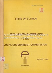 Eltham District Historical Society Inc
Document, Shire of Eltham, Shire of Eltham Preliminary submission to the Local Government Commission, August 1986
... Shire of Eltham Preliminary submission to the Local...Shire of Eltham ...Report produced by the Shire of Eltham in August 1986 as a prelimary response to proposed municipal restructure in the state of Victorianon-fictionReport produced by the Shire of Eltham in August 1986 as a prelimary response to proposed municipal restructure in the state of Victoriacouncil amalgamation, annexation, rates -
Hume City Civic Collection
Sticker, Shire of Bulla
... Shire of Bulla ...This adhesive sticker with Shire of Bulla Sunbury printed on it along with City Living/Country Style a slogan used by the Shire in the 1980's to early 1990's. They were used to stick on any type of flat surface to help promote the area within the Shire of Bulla especially Sunbury.This is a rectangle shape adhesive sticker promoting the Shire of Bulla.Shire of Bulla/City Living/Country Styleshire of bulla, councils, advertising -
 Bacchus Marsh & District Historical Society
Map, O'Hagan v Shire of Bacchus Marsh, Allotment 5, Sec 16, Parish of Korkuperrimul
... O'Hagan v Shire of Bacchus Marsh, Allotment 5, Sec 16...Shire of Bacchus Marsh ...The purpose for this map being created or the date when it was made has not been established. It appears to be documentation relating to a legal dispute by a landowner named O'Hagan and the Shire of Bacchus Marsh. Features identified on the map are allotment 5, section 16, Parish of Korkuperrimul, a 'cultivation paddock', a section of the Werribee River, the path of a section of a 'Main Channel', and a barrier or filled in section across the Werribee River called 'Lee's Filling'. The O'Hagan is likely to be Patrick O'Hagan, 1829-1914 who arrived in Bacchus Marsh in 1864 and was a prominent citizen and landowner in the area for many years until his death in 1914.Single page map showing allotment 5, section 16 in the Parish of Korkuperrimul, Scale 4 chains to inch. Part of a set of maps which are pasted into a bound volume containing 76 maps or plans in total. High resolution digital image stored on BMDHS computer network. Stamped: Munzt, Bace and Muntz, Civil Engineers and Licensed Surveyors , 388 Collins Streetbacchus marsh victoria maps, water supply structures and establishments, watercourses -
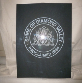 Greensborough Historical Society
Decorative object - Door Pane, glass, Shire of Diamond Valley, 30/09/1964
... Shire of Diamond Valley ...This glass door insert is one of a pair previously inserted into the entrance doors to the Shire of Diamond Valley offices in Greensborough. The Shire of Diamond Valley was a Local Government Area located about 20 kilometres northeast of Melbourne. The shire covered an area of 74.38 square kilometres and existed from 30/09/1964 until 1994. After the local government mergers of 1994, the Shire of Diamond Valley offices were used by the Nillumbik Council.This etched glass is a reminder of the Shire of Diamond Valley. As a large piece of glass it is fragile and could have easily been lost or broken when the Diamond Valley offices changed ownership.Clear glass door insert. Etched with insignia of Shire of Diamond Valley.Glass is etched with the coat of arms of the Shire of Diamond Valley surrounded by inscription 'Shire of Diamond Valley. Proclaimed 1964'.shire of diamond valley, emblems, glass etching, local government buildings, door panels -
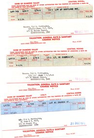 Greensborough Historical Society
Financial record - Account, Shire of Diamond Valley, Shire of Diamond Valley rates notices 1969-1970, 26/03/1958
... Shire of Diamond Valley rates notices 1969-1970...Shire of Diamond Valley ...3 Shire of Diamond Valley Rates assessments issued jointly to Trevor and Gary Partington and their sisters, Mrs Elinor Rowe and Mrs Faye Fort. The locations of the land are Lot 41 Church Street and Lot 67 Scotland Avenue Greensborough. It is possible that this land was purchased by Alan Partington in his adult children's names.Part of the property owned by the Partington family in the original Greensborough farmland. 3 Rates notices, printed in red text with black typed details.Date stamped with rubber stampalan partington, william alan partington, partington family, land deals greensborough, church street greensborough, scotland avenue greensborough