Showing 10763 items
matching sites
-
 Warrnambool and District Historical Society Inc.
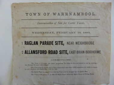
Document, Voting paper Cattle Yards 1883, 1883
This voting card was to determine the site of the new cattle yards in Warrnambool. The choice was between a Raglan Parade site (the present Swan Reserve Children’s Services centre and an Allansford Road site east of the Old Bryen Boiroimhe Hotel (Corner of japan Street and Raglan Parade. The Raglan Parade site at the corner of Kepler Street was the preferred site polling 373 to 222. These saleyards were moved to the present site in Caramut Road in 1970. Portions of the old stone walls around the Raglan Parade / Kepler Street site can still be seen.This document has local interest particularly as the site of the Warrnambool saleyards is still a matter of some discussion.White paper with black text Town of Warrnambool in Capital letters at top of document. The document reads Determination of site for cattle yards. Wednesday February 7th 1883. The back has small sticker W22cattle yards warrnambool, warrnambool, warrnambool saleyards -
 Hume City Civic Collection
Photograph, Late 1980s
A study was conducted to locate a number of Aboriginal sites in Sunbury in the 1980s. This study took place as a result of the expanding development on Sunbury's outskirts.A black and white aerial view of one of the Aboriginal ring sites in Sunburyaboriginal sites, aboriginal rings, george evans collection -
 Port Melbourne Historical & Preservation Society
Photograph - J Kitchen & Sons perimeter survey, Woodruff Street, Dec 2013
As the former j Kitchen & Sons site was being cleared, Lionel Layfield, who had worked at the site for many years undertook several pictorial perimeter surveys. These photos were taken in Dec 2013.Series 1 of colour photographs taken by Lionel Layfield as he walked around the perimeter of the J Kitchen & Sons Pty Ltd factory site during the early demolition of most of the buildings. .31-.36 - looking into the factory site from Woodruff Streetindustry - manufacturing, built environment - industrial, business and traders - soaps/candles, j kitchen & sons pty ltd, symex holdings ltd, north port oval, port melbourne cricket and football oval -
 Sunbury Family History and Heritage Society Inc.
Postcard, Murfett Publishers, 'Rupertswood', C1970s
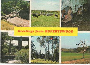
The post card waas assembled by Salesian College, which is in Rupertswood Mansion. The six images are sites within the Rupertswood Estate and are as follows: Clockwise from L-R- Sheep at the Bridge crossing at Jacksons Creek, Friesan Stud sale, Shearing sheep, Jackson Creek flats, Rupertswood Mansion, Railway bridge spanning Jacksons Creek. Initially Salesian College started as an agricultural school training boys in farm skills. It is now a co-educational secondary college.A postcard with six non-digital photographs of sites within the Rupertswood Estate. Information about each site and the manufacturer's details are on the back of the card.Across the centre of the postcard: GREETINGS FROM RUPERTSWOODrupertswood mansion, salesian college, railway viaduct, jacksons creek, sheep shearing, friesan cattle, sunbury -
 Falls Creek Historical Society
Document - Hand-Written - Change Of Name Of Site 4a Buildings To "Southern Cross Flats"
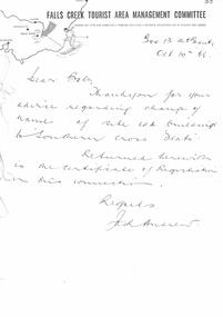
Bob (Herman) Hymans (a former member of the Royal Netherlands Navy) was born in Bloemendaal, Holland on 30th September 1922. During World War II he fought against the Japanese in the Dutch East Indies (now Indonesia) and was imprisoned in Changi and on the Burma Railway. After gaining qualifications as a Ski Instructor, Bob arrived in Falls Creek in July 1950. Working as an Instructor and Supervisor at Bogong Lodge, Bob decided his future was in accommodation. He was successful in negotiating an indenture for land from the State Electricity Commission (SEC). It took Bob two years to build his Grand Coeur Chalet but, tragically, it was burned down in August 1961. Bob also built the first Chairlift in Australia. This was a single chairlift and the structure was built from wooden electricity poles. He was constantly full of new ideas and proposals for the village. Bob Hymans died on 7th July 2007. This Collection of documents and letters tells the story of Bob's endeavours to develop Falls Creek into the ski village it is today.This item is significant because it documents actions taken by the Falls Creek Tourist Area Management Committee in their role overseeing the Tourist Area.A handwritten note from Jack Andrew acknowledged the change of name of Site 4A to 'Southern Cross Flats". The Certificate of Registration was enclosed.TRANSCRIPT Dear Bob Thank you for your advice regarding change of name of site 4A buildings to “Southern Cross Flats”. Returned herewith is the Certificate of Registration in this connection. Regards Jack Andrewfalls creek tourist area management committee, falls creek administration, bob hymans -
 Marysville & District Historical Society
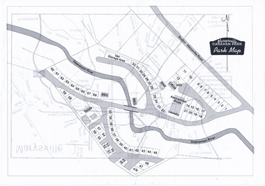
Map (Item) - Marysville Caravan Park map, Marysville CARAVAN PARK-Park Map, Unknown
A map of the Marysville Caravan Park showing the location of the various sites and facilities available to guests.A map of the Marysville Caravan Park showing the location of the various sites and facilities available to guests.marysville, victoria, australia, marysville caravan park, map -
 Clunes Museum
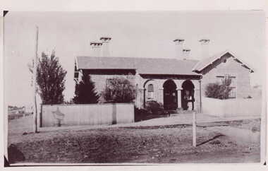
Photograph
PHOTOGRAPH COPIED FROM EARLIER PHOTOGRAPH BY MR. E J SEMMENS. FIRST STAGE OF POST OFFICE - SINGLE STORY BUILDING WITH FIVE CHIMNEYS, SECTIONS OF BUILDING BUILT WITH SMALL BRICKS. GALVANISED IRON FENCE.BLACK AND WHITE PHOTOGRAPH CLUNES POST OFFICE ON SITE OF FORMER POST OFFICE. SINGLE STORIED BUILDING WITH GALVANISED FENCING.On back of photo handwritten in pencil "Clunes" "Clunes Post Office on present site of Post Office" "Copied 30/5/48 EJS" Sticker with "P.D.C 810" handwritten in pencil "20/6" handwritten in pencillocal history, photography, photographs, post office -
 Buninyong & District Historical Society
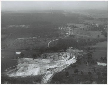
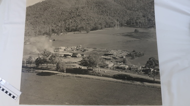
Photograph - Original Photograph, N.L. Harvey and Sons, Ballarat, B/W photo of early site works Mt. Helen Campus of University of Ballarat, 13 May 1968
Educational historyB/W aerial photo of early site works Mt. Helen Campus of University of Ballarat.On rear, "Tertiary Institute site work at Mt. Helen commenced March 1968 (see A.R. 1967-68, p.8 Knowles and Stapleton had earthworks contract" also stamp " N.L. Harvey & Son Photographers 131 Sturt Street Ballarat"buninyong, mt. helen, ballarat university, campus, earthworks -
 Hume City Civic Collection
Photograph, c late 1990s
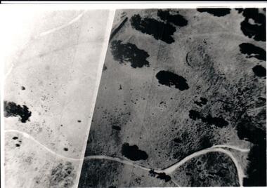
The series of 9 photographs were taken to be included in a study of archaeological sites and Aboriginal rings in the Sunbury area. Five earth rings which are thought to be associated with male initiation ceremonies have been identified in Sunbury. Only 3 others have been found in the rest of Victoria. Despite rapid development in the area, those sites are protected heritage sites.A coloured photograph of an open hillside which is a sacred site. Gum trees and grassy tufts are dotted across the hillside.aboriginal culture, aboriginal rings, sacred sites, george evans collection -
 Kiewa Valley Historical Society
Photo - Tawonga Sawmill
Photo of the Tawonga Sawmill at Tawonga. It was operated by Mt Beauty Timbers P/L circa 1960s. Prior to transfer to Mt Beauty site.The Mt Beauty Timber mill closed in the 1990s due to changes to government legislation regarding logging in the National Park.Black/grey and white aerial photo of the Tawonga Mill site circa 1960s.tawonga sawmill, mt beauty timbers pty ltd, logging -
 Flagstaff Hill Maritime Museum and Village
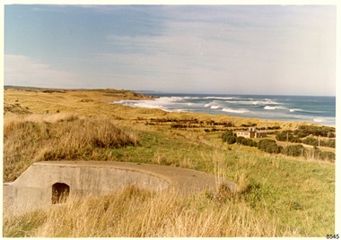
Photograph - Historical, Flagstaff Hill, Warrnambool Garrison Fortifications looking towards the Moyjil (Point Ritchie), 1970s
The photograph shows the location of the concrete, horseshoe shaped gun emplacement erected for the cannons. It is part of the Historic Precinct on Flagstaff Hill. The area was accessed either through the space between the Lighthouses (through the cottage grounds) or a service entrance, past the iron huts used by the Lands Department. This photograph, a print, is one of a set of five that show the site of Flagstaff Hill. It is presumed to have been taken by John Lindsay, Founding Director of Flagstaff Hill Maritime Museum and Village. One of the photographs in the set has the pencil inscription "Photo J Lindsay". It was taken in the early 1970s during the initial stages of the development of Flagstaff Hill as a Museum and Maritime Village. The photographs belonged to the donor's grandparents, who lived in the Warrnambool district of Allansford/Naringal. The photograph is a record of the site and surrounds of Flagstaff Hill Maritime Museum and Village before its development and opening in 1975. It shows the east side of the Surfside Holiday Park in its earlier days. The photograph is significant for recording the location and condition of the original concrete cannon emplacement on the Hill.Coloured photograph, glassy print, one of a set of five. Photograph shows the original site of one of the gun emplacements for the cannons, cannons Historical, looking towards the Moyjil, ,Point Ritchie and overlooking Lady Bay, Warrnambool. The horseshoe shaped concrete gun emplacement is in the foreground on the grassed slopes overlooking the Bay. The site and ablution block of the Surfside Holiday Park is centre right. The left shows the sore of Lady Bay with the cliffs of the Southern Ocean in the distance. The photograph's paper has the printer's watermark on the back. The early 1970s scene is presumed to have been photographed by John Lindsay, Warrnambool.Label on the back: "FIRST GUN EMPLACEMENT LOOKING TOWARDS THE HOPKINS / This is the original site of one of the cannons overlooking the Bay. Access to this area could be between the light-houses (throught the cottage grounds), or a service entrance - past the iron huts used by Lands Department."flagstaff hill, flagstaff hill maritime museum and village, warrnambool, maritime museum, maritime village, great ocean road, shipwreck coast, 1970s, photograph, gun emplacement, surfside holiday park, lady bay, hopkins river, flagstaff hill site, john lindsay, concrete gun emplacement, cannon emplacement, original emplacement -
 Buninyong & District Historical Society
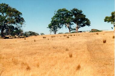
Photograph - Photograph colour of site of Mt Helen Ballarat Institute of Advanced Education 1968, View of Ballarat Institute of Advanced Education (Federation University) site Mt Helen, 1968
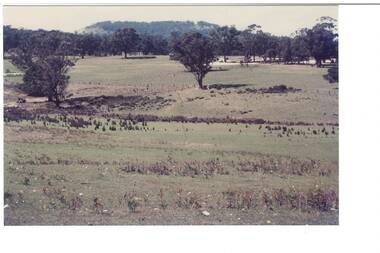
Colour photograph of site of Ballarat Institute of Advanced Education 1968 showing Mount BuninyongThe construction of the Mt. Helen campus in the 1970s in the predominately rural area was an important milestone in the expansion of tertiary education in the Central HighlandsColour photograph of Ballarat Institute of Advanced Education site Mt Helen toward Mount Buninyong1968Mt. Helen - Towards Mt Buninyong from N.W. 1968 Before Campus Beginseducation, ballarat institute of advanced education, federation university, landscape, mt. helen, mount buninyong -
 Whitehorse Historical Society Inc.
Document - Pamphlet, Blackburn - a mural depicting its history, 1996
Leaflet describing a mural sponsored by Blackburn Library Arts ProjectLeaflet describing a mural sponsored by Blackburn Library Arts Project depicting 33 local people, places and sites.Leaflet describing a mural sponsored by Blackburn Library Arts Project blackburn, murals, landcare and environment action group program, blackburn library arts program -
Marysville & District Historical Society
Document (item) - Historic Site Register Sheet, Parks Victoria, Historic Site Recording System-Site Register Sheet-Chester & Locke Mine, 1989
A copy of a historic site register sheet for the Chester and Locke gold mine near Marysville in Victoria.A copy of a historic site register sheet for the Chester and Locke gold mine near Marysville in Victoria. The Golden Bower gold mine was a quartz reef mine. William Edward Chester discovered the Golden Secret gold vein which became part of the Golden Bower Mine at Chesterville near Donovans Creek on the Cumberland goldfield which he mined with George Locke until the late 1930s. chester and locke mine, william chester, george locke, cambarville, yarra ranges, walker's hotel, marysville, victoria -
 Hume City Civic Collection
Photograph, c late 1990s
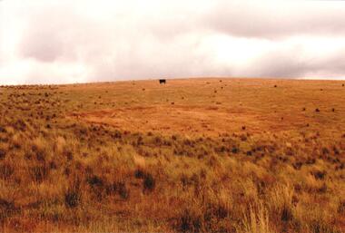
The series of 9 photographs were taken to be included in a study of archaeological sites and Aboriginal rings in the Sunbury area. Five earth rings which are thought to be associated with male initiation ceremonies have been identified in Sunbury. Only 3 others have been found in the rest of Victoria. Despite rapid development in the area, those sites are protected heritage sites.A coloured photograph of an Aboriginal Ring which is a proclaimed sacred site on an open grassy hillside. A black cow is standing in the distance.aboriginal culture, aboriginal rings, sacred sites, george evans collection -
 Hume City Civic Collection
Photograph, c late 1990s
The series of 9 photographs were taken to be included in a study of archaeological sites and Aboriginal rings in the Sunbury area. Five earth rings which are thought to be associated with male initiation ceremonies have been identified in Sunbury. Only 3 others have been found in the rest of Victoria. Despite rapid development in the area, those sites are protected heritage sites.A view of the Aboriginal ring and sacred site and its close proximity to a proposed housing estate at Sherwood near Racecourse Road.aboriginal culture, aboriginal rings, sacred sites, george evans collection -
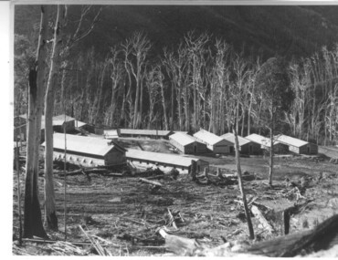 Kiewa Valley Historical Society
Photograph of Howmans Dam Camp, Howmans Dam Camp, circa 1948
Howman's Gap camp was erected in 1948. The proposed dam to be built at this site was postponed in 1954 because of financial restraints imposed by the government at this time. It was to have supplied water for No. 2 Power Station at the Junction of the Pretty Valley and Rocky Valley branches of the East Kiewa River. This power station was not constructed until 2008 - 2010 and now gets it water from McKay Creek Power Station. The site of this camp is now occupied by the Howman's Gap Alpine Centre. Some of the original buildings still remain. An excellent photographic record of the type of buildings and size of the camp for accommodation of workmen during construction of the Kiewa Hydro Electric Scheme.Black and white photograph of the buildings erected at Howmans Dam site as accommodation for workmen.Handwritten in blue ink on the back of photograph "Howmans Dam Camp"howman's gap, camp, water, dam -
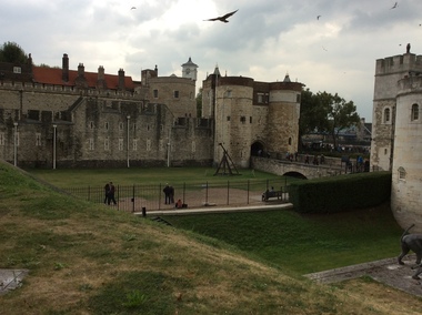 Ballarat Heritage Services
Digital photograph, Dorothy Wickham, Tower of London, 2016
The Tower of London, officially Her Majesty's Royal Palace and Fortress of the Tower of London, is a historic castle located on the north bank of the River Thames in central London. It lies within the London Borough of Tower Hamlets, separated from the eastern edge of the square mile of the City of London by the open space known as Tower Hill. It was founded towards the end of 1066 as part of the Norman Conquest of England. The White Tower, which gives the entire castle its name, was built by William the Conqueror in 1078, and was a resented symbol of oppression, inflicted upon London by the new ruling elite. The castle was used as a prison from 1100 (Ranulf Flambard) until 1952 (Kray twins),[3] although that was not its primary purpose. A grand palace early in its history, it served as a royal residence. As a whole, the Tower is a complex of several buildings set within two concentric rings of defensive walls and a moat. There were several phases of expansion, mainly under Kings Richard the Lionheart, Henry III, and Edward I in the 12th and 13th centuries. The general layout established by the late 13th century remains despite later activity on the site. The Tower of London has played a prominent role in English history. It was besieged several times, and controlling it has been important to controlling the country. The Tower has served variously as an armoury, a treasury, a menagerie, the home of the Royal Mint, a public record office, and the home of the Crown Jewels of England. From the early 14th century until the reign of Charles II, a procession would be led from the Tower to Westminster Abbey on the coronation of a monarch. In the absence of the monarch, the Constable of the Tower is in charge of the castle. This was a powerful and trusted position in the medieval period. In the late 15th century the castle was the prison of the Princes in the Tower. Under the Tudors, the Tower became used less as a royal residence, and despite attempts to refortify and repair the castle its defences lagged behind developments to deal with artillery. The peak period of the castle's use as a prison was the 16th and 17th centuries, when many figures who had fallen into disgrace, such as Elizabeth I before she became queen, Sir Walter Raleigh, and Elizabeth Throckmorton were held within its walls. This use has led to the phrase "sent to the Tower". Despite its enduring reputation as a place of torture and death, popularised by 16th-century religious propagandists and 19th-century writers, only seven people were executed within the Tower before the World Wars of the 20th century. Executions were more commonly held on the notorious Tower Hill to the north of the castle, with 112 occurring there over a 400-year period. In the latter half of the 19th century, institutions such as the Royal Mint moved out of the castle to other locations, leaving many buildings empty. Anthony Salvin and John Taylor took the opportunity to restore the Tower to what was felt to be its medieval appearance, clearing out many of the vacant post-medieval structures. In the First and Second World Wars, the Tower was again used as a prison, and witnessed the executions of 12 men for espionage. After the Second World War, damage caused during the Blitz was repaired, and the castle reopened to the public. Today the Tower of London is one of the country's most popular tourist attractions. Under the ceremonial charge of the Constable of the Tower, it is cared for by the charity Historic Royal Palaces and is protected as a World Heritage Site.(Wikipedia) A World Heritage Site is a landmark which has been officially recognized by the United Nations, specifically by UNESCO. Sites are selected on the basis of having cultural, historical, scientific or some other form of significance, and they are legally protected by international treaties. UNESCO regards these sites as being important to the collective interests of humanity. More specifically, a World Heritage Site is an already classified landmark on the earth, which by way of being unique in some respect as a geographically and historically identifiable piece is of special cultural or physical significance (such as either due to hosting an ancient ruins or some historical structure, building, city, complex, desert, forest, island, lake, monument, or mountain) and symbolizes a remarkable footprint of extreme human endeavour often coupled with some act of indisputable accomplishment of humanity which then serves as a surviving evidence of its intellectual existence on the planet. And with an ignoble intent of its practical conservation for posterity, but which otherwise could be subject to inherent risk of endangerment from human or animal trespassing, owing to unmonitored/uncontrolled/unrestricted nature of access or threat by natural or accelerated extinction owing to local administrative negligence, hence it would have been listed and demarcated by the United Nations Educational, Scientific and Cultural Organization (UNESCO) to have been identified or recognised and officially christened and internationally elevated through multilateral declaration by UNESCO as a universally protected zone. [1] The list is maintained by the international World Heritage Programme administered by the UNESCO World Heritage Committee, composed of 21 UNESCO member states which are elected by the General Assembly. (Wikipedia)The Tower of London is a UNESCO world heritage site.tower of london -
 Whitehorse Historical Society Inc.
Photograph, Stanley Works, c1972
In 1970 - Titan Pty Ltd acquired Turner Industries of Nunawading (Turner had commenced making tools there in 1936). In 1971 the Stanley Works was formed from Stanley-Titan and Turner Industries. Stanley Works ceased manufacture on the Nunawading site in 1992. The site now belongs to Harvey NormanBlack and white photo c1972 of Stanley Works, Whitehorse Road, Nunawading. Now the site of Harvey Normanstanley works pty ltd, tools -
Whitehorse Historical Society Inc.
Document, 56-74 Station Street Nunawading, 2013
Major commercial property sale, 394 x 164 metres, sold for $22,000,000. The site is expected to be vacated in April 2015.Major commercial property sale, 394 x 164 metres, sold for $22,000,000. The site is expected to be vacated in April 2015.Major commercial property sale, 394 x 164 metres, sold for $22,000,000. The site is expected to be vacated in April 2015.station street nunawading, nos.56-74, daniel robertson australia pty ltd., brickworks -
Whitehorse Historical Society Inc.
Article, $3.4 million road development opened
Article about the opening of home units for the agedArticle about the opening of home units for the aged in the former migrant hostel site in Rooks Road, Nunawading. With photo.Article about the opening of home units for the agedretirement homes and villages, harrowfield, john, mccutcheon, andrew, bradley, norman, bradley, agnes, rooks road, nunawading -
Federation University Historical Collection
Document, Eureka Stockade Site, 1991, 14/05/2014
The Eureka Stockade was attached on 03 December 1854. It is not certain where the actual site of the stockade is. Ten typed pages of notes relating to the site of the Eureka Stockade by Iain Stuart of the Victoria Archaeological surveyeureka, eureka stockade, eureka stockade site, phillip clingin, iain stuart, eureka, eureka stockade, eureka stockade site, phillip clingin, iain stuart -
 Whitehorse Historical Society Inc.
Photograph, Vermont Primary School
In 1872, pupils began the school year in the building. By 1958 a new site opened in Nurlendi Road, Vermont. After standing derelict for many years, the old Vermont Primary School was moved to the Nurlendi site in 1992Coloured photo of Vermont Primary School No.1022 on the original site on the north-west corner of the junction of Mitcham and Canterbury Roads.vermont primary school no.1022, primary schools -
Whitehorse Historical Society Inc.
Article, Plans To Consolidate Three Campuses, 21/09/1994 12:00:00 AM
Article on the consolidation of Millauna Secondary Colleges, three campuses on to one site at Mitcham Road, due to operate in 1996.Article on the consolidation of Millauna Secondary Colleges, three campuses on to one site at Mitcham Road, due to operate in 1996.Article on the consolidation of Millauna Secondary Colleges, three campuses on to one site at Mitcham Road, due to operate in 1996.secondary schools, millauna secondary college -
 Greensborough Historical Society
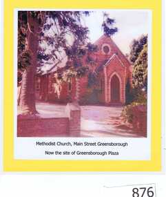
Photograph, Unknown, Methodist Church Main Street Greensborough, 1940c
The Greensborough Methodist Church stood in Main Street Greensborough and was central to the social life of the suburb in the early 20th century. This original site is now part of the Greensborough Plaza shopping complex. The Church moved to the new building in Grimshaw Street circa 1970s. This photograph shows the red brick church, now demolished.Copy of colour photograph of red brick church, mounted on yellow card and laminated.Caption: 'Methodist Church, Main Street Greensborough. Now the site of Greensborough Plaza'methodist church greensborough -
Whitehorse Historical Society Inc.
Map, Kylana Estate Tunstall, 1926
Auctioneer's plan of sub-division of Kylana Estate Tunstall.Auctioneer's plan of sub-division of Kylana Estate Tunstall, 8 sites, 2nd Oct 1926. Auctioneer: Sergeant & LehmannAuctioneer's plan of sub-division of Kylana Estate Tunstall.heather grove tunstall, kylana estate, springvale road tunstall, tunstall -
 Melbourne Tram Museum
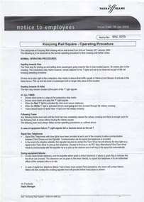
Document - Notice to Employees, Yarra Trams, "Kooyong Rail Square - Operating Procedure", Jan 2008
Document provides information on the operation of the rail square (also known as a tram square, railway Square) at the Kooyong Glenferrie Road level crossing. Provides a site plan, signal information and operational procedures including when items fail. Dated 16/1/2008.Demonstrates an instruction into the operation of the Kooyong rail squareSingle A4 sheet, printed double sided, with a coloured site plan.trams, tramway square, rail square, railway square, glenferrie road, kooyong level crossing, operations, instructions -
 Whitehorse Historical Society Inc.
Photograph, Original Site of Schwerkolt Home, 14/02/2001 12:00:00 AM
Photographed by Ted Goode to record the topography of site. Proposed Eastern Freeway Extension will cut through the treed area.Three copies of the view of original site of Schwerkolt home - now horse paddock adjoining Cottage Reserve.schwerkolt family, schwerkolt, original cottage site., goode, ted, horse paddock -
 Lakes Entrance Historical Society
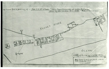
Photograph - New Works Plan, 1898
Map traced from a photocopy of :- Map TP8A Bairnsdale. 'Site. Sand Hummocks of Lakes Entrance'. Drawn by John Lardner 18 January 1898. Scale two chains to one inch. ( A photocopy of this map in Latrobe Library map collection, June 1983)Black and white photograph showing sketch map of 1898 by John Lardner Plan of Sites - sand hummocks. Drawing shows sites of buildings at entrance along Cunninghame Arm shoreline at Lakes Entrance, Victoria.land settlement, plan -
Whitehorse Historical Society Inc.
Article, Grant To Improve Mullauna College, 5/07/2000 12:00:00 AM
Article on State Government's $3.7 million grant to consolidate the three campuses of Millauna Secondary College oneArticle on State Government's $3.7 million grant to consolidate the three campuses of Millauna Secondary College at one site on Mitcham Road by 1996.Article on State Government's $3.7 million grant to consolidate the three campuses of Millauna Secondary College one secondary schools, millauna secondary college