Showing 91537 items matching "tambo-shire-history"
-
 Learmonth and District Historical Society Inc.
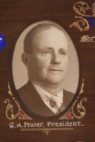
Photo - Fraser, Thornton Richards & Co Ballarat, Fraser. G.A. Shire President, 1954, 1954 (exact)
Councilor George Alexander Fraser was elected to council in 1947 and served until 1960. On Monday 7th September 1953 he was sworn in as Shire President for the 1953/54 year, having been nominated by Cr. Edwards. This collection Of photos was taken to comemorate the visit on the 6th of March 1954,to Ballarat, of Her Majesty Queen Elizabeth 11,and was presented to Council by the Shire President to mark the occaision.Section of the Original Historic Photo of Councilors for the year 1954.Sepia/Brown Photo Councilor G.A.Fraser who was Shire President for the year 1953-54.It is in the top left hand corner of a composite photo of Councilors for that year.Collection of Photos showing Shire Presidrnt & Councilors for the Financial Year 1953-54..george alexander fraser shire president 1953 54, visit queen elizabeth 11 ballaret 6th march 1954 -
 Ringwood and District Historical Society
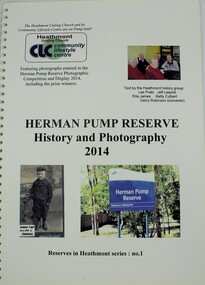
Book, Heathmont History Group, Herman Pump Reserve, Heathmont - History and Photography 2014, 2014
Soft cover metal & plastic bound book featuring photographs entered in the Herman Pump Reserve Photographic Competition and Display 2014, including the prize winners.Reserves in Heathmont series: no.1. Text by the Heathmont History Group - Les Prato, Jeff Leipold, Gerry Robinson (convenor), Rita James, Betty Colbert. -
 Ringwood and District Historical Society
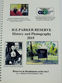
Book, Heathmont History Group, H.E. Parker Reserve, Heathmont - History and Photography 2015, 2015
Soft cover metal & plastic bound book featuring photographs entered in the H.E. Parker Reserve Photographic Competition and Display 2015, including the prize winners.Reserves in Heathmont series: no.2. Text by the Heathmont History Group - Les Prato, Jeff Leipold, Gerry Robinson (convenor), Rita James, Betty Colbert. -
 Ringwood and District Historical Society
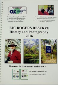
Book, Heathmont History Group, FJC Rogers Reserve, Heathmont - History and Photography 2016, 2016
Soft cover metal & plastic bound book featuring photographs entered in the FJC Rogers Reserve Photographic Competition and Display 2016, including the prize winners.Reserves in Heathmont series: no.3. Text by the Heathmont History Group - Les Prato, Jeff Leipold, Gerry Robinson (convenor), Rita James, Betty Colbert. -
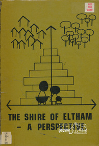 Eltham District Historical Society Inc
Book, Shire of Eltham, The Shire of Eltham - A Perspective, July 1981
This report was produced by the Shire of Eltham (Planning Department) following a population study of the Shire. It also includes other areas of general interest. The Document contents includes Present and Future - Population - Housing - Residential Lands - Social Characteristics - Development and History. Includes maps, tables and diagrams. Part 1: The Existing situation - introduction, the Shire of Eltham, physical characteristics, historical development, population growth. Characteristics of the population - size and distribution, age / sex, natural increase, migration. Socio-Economic Factors: socio-economic status, employment/workforce, education, other social factors. Housing/ building statistics: characteristics of Housing stock, current residential trends, other types of building activity. Residential Land: existing vacant lots, estimated additional lots. Part 2: The Future. Land availability, the future population.The Shire of Eltham Council resolved on publication of this report "to commend it to the ratepayers as a most valuable resource document". It provides a comprehensive statistical review of the Shire of Eltham, Victoria in 1981 with some population and development predictions for the future.Spiral bound, soft cover, includes indexBarcode and identification markings including stamped "WITHDRAWN" from Heidelberg Regional Library Serviceshire of eltham, planning, population -
 Lakes Entrance Historical Society
Book, Barned, Kim, Tambo Upper Low Level Bridge, 2003
Research, interpretation and management recommendations for the Tambo Upper Low Level Bridge, East Gippsland,Victoria, by a Forestec student.bridges, waterways, natural disasters -
Tatura Irrigation & Wartime Camps Museum
Archive Box, Shire of Rodney, 2009
Grey Archive Box contains Shire of Rodney recordsLabelled "Shire of Rodney" and numbered "4359"shire of rodney, archive, box -
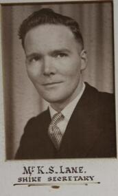 Learmonth and District Historical Society Inc.
Photo - Kane, Possibly Drummond Studios, Kane.K.S.( Mr).Shire Secretary,1959, 1959
Mr. K.S.Lane was Shire Secretary for the Ballarat Shire Council in 1959.This forms part of a composite collection of photos presented by the Shire Preident,to commemorate the opening of the Wendouree Municiple Centreon 20th November 1959. Original Historical Photo of all Councilors for the year 1959Mr.K.S. Lane,(Shire Secretary).Sepia photo (rectangular) on white mount,situated left hand side of middle row,of composite photo of all councilors for the year 1959. Shire President Charles Edward,"Ted" Brown and councilors,commemorating opening of Wendouree Municiple Centre 20th November 1959.wendouree municiple centre opening 20th november 1959, ballarat shire council, lane k s mr, shire secretary 1959 -
Lakes Entrance Historical Society
Book, East Gippsland Shire Council, East Gippsland Shire Rating Strategy Document 1995, 1995
Strategy document which examines the options East Gippslands Shire Council has to introduce a fair and uniform rate over the newly amelgamated municipality considering that the State Government requires a 20% reduction in rate income in the first year Easlocal government -
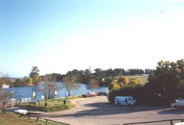 Lakes Entrance Historical Society
Photograph, M Holding, Jetty and boat ramp Tambo River Johnsonville 1999, 1999
Colour photograph of Johnsonville jetty boat ramp and parking area before installation of new jetty on Tambo River Johnsonvillehouses -
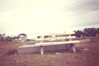 Lakes Entrance Historical Society
Photograph - Cemetery Lakes Entrance Victoria, Vera Bennett, timber seat in the cemetery Lakes Entrance Victoria, 1991
donated by the Tambo Shire Historical Society Colour photograph of the timber seat donated by the Tambo Shire Historical Society in memory of early residents in the cemetery Palmer Road Lakes Entrance Victoriahistorical society, historic sites, cemeteries, trees -
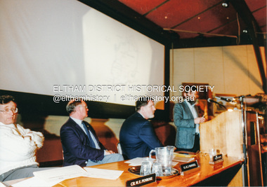 Eltham District Historical Society Inc
Photograph, Shire of Eltham, Meeting to discuss the new Nillumbik Shire, November 1994
Nillumbik Shire Council - Shire of Eltham Archives Series 046Nillumbik Shire Council - Shire of Eltham Archives Series 046 Series consists of colour photographs, 215mm x 150mm, depicting citizens and speakers at the meeting, including CEO Rodney Roscholler.Colour photograph1994, council amalgamation, nillumbik shire, public meeting, shire of eltham, series 46, shire of eltham archives -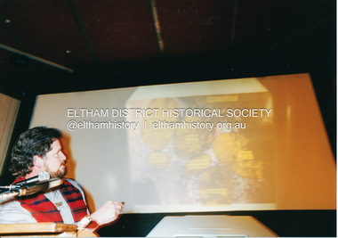
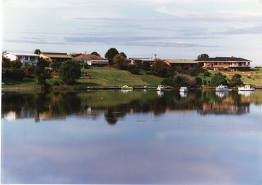 Lakes Entrance Historical Society
Photograph - Lakes Entrance, Tambo Shire, 1994 c
Also second identical copyColour photograph of a section of the North Arm adjacent to Ferndale Parade, shows the rear view of six houses, five small boats moored at lake edge. Lakes Entrance Victoriajetties, houses, waterways, boats and boating, township -
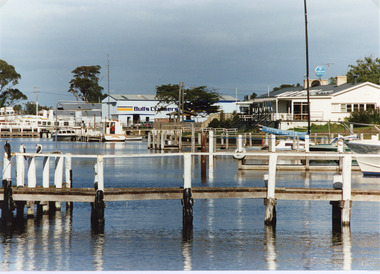 Lakes Entrance Historical Society
Photograph - Metung Hotel, Tambo Shire, 1994 c
Also second identical copyColour photograph of the waterfront adjacent to Metung Hotel, showing jetties, hotel and Bulls Cruisers. Metung Victoriajetties, boats and boating, waterfront, hotels -
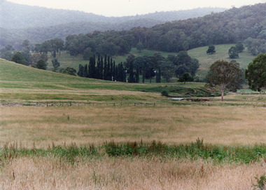
 Lakes Entrance Historical Society
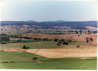
Photograph - Mossiface Flats, Tambo Shire, 1994
Also second identical copyColour photograph of the Mossiface Flats, near Bruthen, shows paddocks of the rich river flats, timbered foothills in the distance, with mountain range behind. Some paddocks have been mown for grass hay. Farm buildings in foreground and background. Dam in foreground. Bruthen Victoriaanimals, agriculture, vegetation, topography -
 Lakes Entrance Historical Society
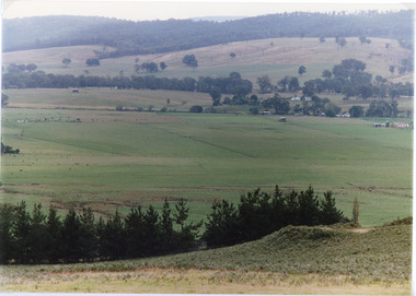
Photograph - Sarsfield Flats, Tambo Shire, 1994 c
Also second identical copyColour photograph of Sarsfield Flats. Distant view of cattle grazing and farm buildings, foothills in background, and glimpse of mountains. Pine trees in the foreground. Bruthen Victoriaagriculture, topography -
 Lakes Entrance Historical Society
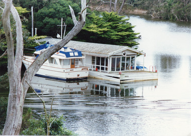
Photograph - Box's Creek, Tambo Shire, 1994
Also second identical copyColour photograph of a holiday house, built over the water at Box's Creek, a motor cruiser moored beside the house. Metung Victoriawaterways, tourism, boats and boating -
 Lakes Entrance Historical Society
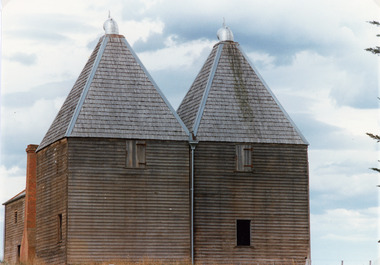
Photograph - Hop Kiln, Tambo Shire, 1994
Also second identical copyColour photograph of the hop kilns at Mossiface, shown buildings and shingle roof in good order. Mossiface Victoriabuildings, historic sites -
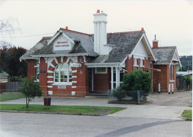 Lakes Entrance Historical Society
Photograph - Postal Office Bruthen, Tambo Shire, 1994 c
Also second copy identicalColour photograph of Post Office, shows a brick building, slate covered, gable roof, decorative brickwork around windows, tall chimneys with chimney pots, decorative tiles on roof ridges. Commonwealth Savings Bank sign under window. Bruthen Victoria buildings, postal services -
 Lakes Entrance Historical Society
Photograph - Timbarra, Tambo Shire, 1994 c
Colour photograph of grazing country in the Timbarra region, showing well grassed paddocks in foreground farm buildings in valley wooded foothills in background. Timbarra Victoriaagriculture, primary industry, animals -
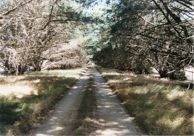 Lakes Entrance Historical Society
Photograph, Tambo Shire, 1994 c
Also second identical copyColour Photograph of a typical farm driveway, shows a long driveway bordered with cypress trees. Nicholson Victoriaroads and streets -
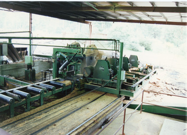 Lakes Entrance Historical Society
Photograph, Tambo Shire, 1996 c
Also second identical copyColour photograph taken from inside sawmill, showing saw bench and machinery. Nowa Nowa Victoriamachinery -
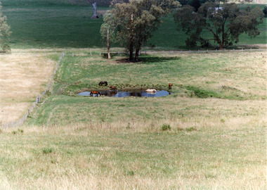 Lakes Entrance Historical Society
Photograph, Tambo Shire, 1994 c
Also second identical copyColour photograph of a rural view near Buchan, shows five horses in and around a dam, farming building in distance glimpsed through trees. Bruthen Victoria topography, agriculture -
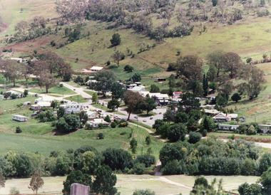 Lakes Entrance Historical Society
Photograph - Buchan, Tambo Shire, 1994 c
Also second identical copyColour photograph of the township of Buchan, taken from a high point above the town which is situated in a valley with hills rising on all sides. Buchan Victoriatownship, topography -
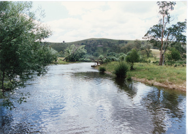 Lakes Entrance Historical Society
Photograph - Buchan River, Tambo Shire, 1994 c
Colour photograph of the Buchan river, showing stream flowing between low banks, hills rising in distance. Buchan Victoria topography, waterways -
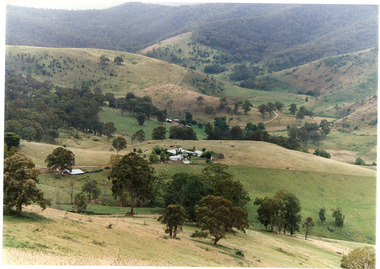
 Lakes Entrance Historical Society
Photograph - Buchan Station, Tambo Shire, 1994 c
Also second identical copyColour photograph of Buchan Station, shows farming buildings situated among trees, both cultivated and uncultivated paddocks around property, forested hills in background. Buchan Victoriaagriculture, animals, topography -
 Lakes Entrance Historical Society
Photograph, Tambo Shire, 1994 c
Also second identical copyColour photograph of grazing country near Buchan, showing cattle on grassy flat rugged rocky hill in background. Buchan Victoriavegetation, primary industry -
 Lakes Entrance Historical Society
Photograph, Tambo Shire, 1994
Also second similar copyColour photograph taken at The Basin, showing hilly farmland, dense forest on ranges in distance. Buchan Victoriatopography, vegetation -
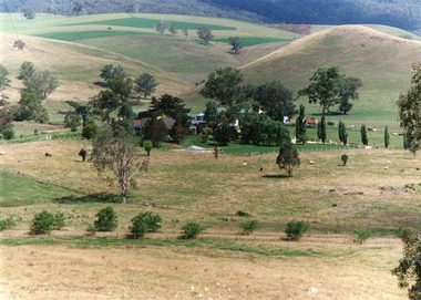
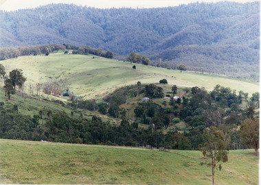
 Lakes Entrance Historical Society
Photograph - Gillingal Station, Tambo Shire, 1994 c
Also second identical copyColour photograph of Gillingal Station, showing the farm buildings situated on a hillside and surrounded by rising hill country and fertile valleys, cattle grazing in home paddock. Buchan Victoriaagriculture, primary industry