Showing 10017 items matching "the dandenongs"
-
 Dandenong & District Historical Society
Journal, Dandenong & District Historical Society, Gipps-Land Gate Vol.4 No.4, 1974
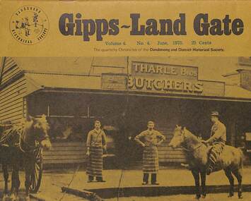
An interesting group of Early Dandenong Personalities, Places and EventsA5 size publication of the Gipps-Land Gate, December 1974. 16 pages, featuring an old picture of Dandenong on the cover.An interesting group of Early Dandenong Personalities, Places and Eventshotel history, early education in dandenong, interesting milestones, family histories -
 Dandenong & District Historical Society
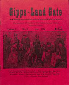
Journal, Dandenong & District Historical Society, Gipps-Land Gate Vol.5 No.2, 1976
An interesting group of Early Dandenong Personalities, Places and EventsA5 size publication of the Gipps-Land Gate, December 1974. 16 pages, featuring an old picture of Dandenong on the cover.An interesting group of Early Dandenong Personalities, Places and Eventshotel history, early education in dandenong, interesting milestones, family histories -
 Dandenong & District Historical Society
Journal, Dandenong & District Historical Society, Gipps-Land Gate Vol.5 No.1, 1975
An interesting group of Early Dandenong Personalities, Places and EventsA5 size publication of the Gipps-Land Gate, December 1974. 16 pages, featuring an old picture of Dandenong on the cover.An interesting group of Early Dandenong Personalities, Places and Eventshotel history, early education in dandenong, interesting milestones, family histories -
 Dandenong & District Historical Society
Journal, Dandenong & District Historical Society, Gipps-Land Gate Vol.5 No.3, 1976
An interesting group of Early Dandenong Personalities, Places and EventsA5 size publication of the Gipps-Land Gate, December 1974. 16 pages, featuring an old picture of Dandenong on the cover.An interesting group of Early Dandenong Personalities, Places and Eventshotel history, early education in dandenong, interesting milestones, family histories -
 Dandenong & District Historical Society
Journal, Dandenong & District Historical Society, Gipps-Land Gate Vol.5 No.4, 1976
An interesting group of Early Dandenong Personalities, Places and EventsA5 size publication of the Gipps-Land Gate, December 1974. 16 pages, featuring an old picture of Dandenong on the cover.An interesting group of Early Dandenong Personalities, Places and Eventshotel history, early education in dandenong, interesting milestones, family histories -
 Southern Sherbrooke Historical Society Inc.
Information folder - Dandenong Ranges Steiner School, 2007
Information folder containing items pertaining to the Dandenong Ranges Steiner School, Menzies Creek & Lysterfield. Contents:/- typescript, "The Dandenong Ranges Steiner School", a brief history of the school written by Louise Reidsimmons for Lisa Hall's update of Menzies Creek Primary School's centenary book, n.d. but c. 2007, one sheet."For Lisa Hall" written in blue ink at top of pagedandenong ranges steiner school, menzies creek hall, menzies creek shop, melbourne water buildings, cardinia reservoir -
 Ringwood and District Historical Society
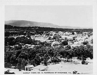
Photograph/Postcard, Souvenir photograph - Murray Views No.13. Panorama of Ringwood, Vic
Black and white "Murray Views" souvenir photograph overlooking Ringwood towards Dandenong Ranges from Loughnan Hill, circa 1940s. -
 Ringwood and District Historical Society
Photograph-B&W, Joan Walker, East Ringwood 2000-Maroondab Club in Mount Dandenong Road Ringwood East, 2000
East Ringwood 2000-Maroondab Club in Mount Dandenong Road Ringwood East- B&W Photo from Album 6501 -
 Bendigo Historical Society Inc.
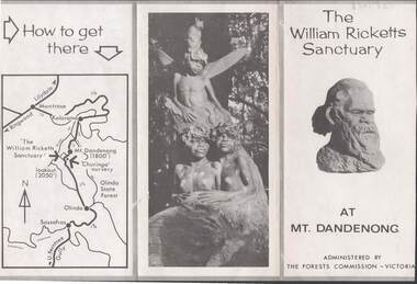
Document - LYDIA CHANCELLOR COLLECTION: THE WILLIAM RICKETTS SANCTUARY
A leaflet about the history and location of the William Ricketts Sanctuary at Mt. Dandenong. Is administered by The Forests Commission Victoria. C 1964 mapplace, public gardens, willilam ricketts sanctuary, mt. da, lydia chancellor, collection, tourism, geography, travel, map, the william ricketts sanctuary, dandenong, recreation, victoria, exploration, history, place -
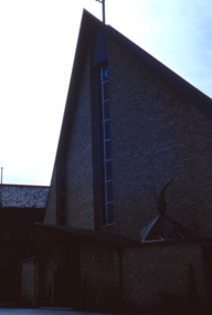
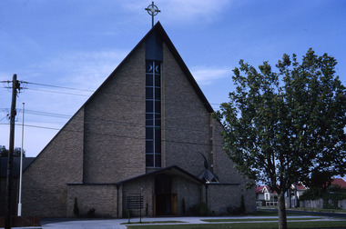 Robin Boyd Foundation
Slide, Robin Boyd, 1965
Colour slide in a mount. Church of the Holy Eucharist, 1241 Dandenong Road, East Malvern, 1962. (Architects: Alan Robertson and Associates.)Made in Australia / 36 / JAN 65Mmelbourne, slide -
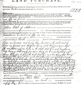 Whitehorse Historical Society Inc.
Legal record - Land Title, Land Purchase, 2/02/1858
Photocopy of agreement for land purchase by auction held on 2 February 1858.Photocopy of agreement for land purchase by auction held on 2 February 1858. Purchase by Nelson Polak of land adjacent to Dandenong Creek.Photocopy of agreement for land purchase by auction held on 2 February 1858. polak, nelson, dandenong creek, land sales -
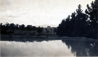 Whitehorse Historical Society Inc.
Photograph, Jones Flower Farm
Jones Family Collection - NP2565 to NP2606. See also ND3831.Black and white photograph of water storage dam with the Dandenongs in the backgounnd - Jones' Flower Farm in Mt Pleasant Road, Nunawading, in 1928jones, bette, walter, rolf, geoffrey, arthur, keith, lionel, muriel, jones flower farm, mount pleasant road nunawading -
Whitehorse Historical Society Inc.
Document - Correspondence, Roads, 01/06/-/10/1933
Correspondence between shires of Blackburn and Mitcham, and Dandenong and City of Chelsea to declare Springvale Road a main road, June- October 1933.springvale road, nunawading, victoria. country roads board, shire of blackburn and mitcham, shire of dandenong, city of chelsea, roads and streets -
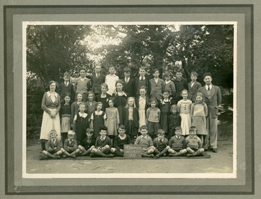 Mt Dandenong & District Historical Society Inc.
Photograph, Mt Dandenong School 3284 1937, 1937
Formal school photograph showing staff and students of Mt Dandenong State School No. 3284 taken in 1937. Mounted on stiff cardboard.Handwritten on rear of photograph: Betty Jeeves (Law Smith) 3rd from right second front row. Ken Jeeves 1st left, back row. Stamped on back G.E.HAINS Photographer 61 HARCOURT ST. HAWTHORN EAST, E3 1/6mt dandenong school, betty jeeves, ken jeeves, elizabeth law smith -
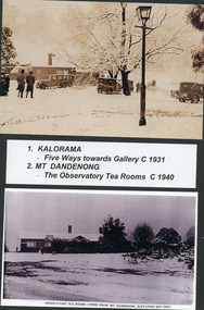 Mt Dandenong & District Historical Society Inc.
Photograph, Kalorama Snow Scenes 1 & 2, c1931
1. Snow at FiveWays c1931. Lamp, cars and gallery visible. 2. Snow at Observatory Tea Rooms Mt. Dandenong c1940kalorama, snow -
 Dandenong/Cranbourne RSL Sub Branch
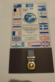
Work on paper - Korean War Medal, Circa 1950
Korean Veterans Association of Australia Inc. Donated to Dandenong RSL by Major General J C Hughes AO DSO MC.Korean Veterans Association Patron: Major General J C Hughes AO, DSO, MC. The Korean War 1950 - 1953. Bordered by the Flags of 21 Nations. -
 Federation University Historical Collection
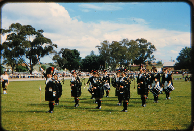
Photograph - Photograph - slide transparency, Ballarat Ladies' Highland Pipe Band at Dandenong, 1957
"After the war Pipe-Major Duncan McLennan, moved to Ballarat and took up a position as cadet instructor and leader of the Ballarat Highland Pipe Band and the Ballarat Ladies Pipe Band. " (Victorian Historical Journal Vol. 85, No. 1, June 2014)Coloured photograph of taken from a slide.Written on slide - Dandenong Nov 57 Ballarat Ladies Bpipe band, ballarat, ladies, ladies pipe band, highland pipe band, photograph, coloured photograph, slide -
Dandenong/Cranbourne RSL Sub Branch
Tribute Certificate
Details of PTE Griffiths' service can be found in the attached service record.Cardboard certificate with various flags and photographs of King George V, Sir Edward Grey and Lord Kitchener.A tribute from the citizens of the Shire of Dandenong to Herbert Wallace Griffiths. -
 Mt Dandenong & District Historical Society Inc.
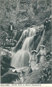
Photograph, Olinda Falls at Mt Dandenong, Early 1900s
Photograph from the Dower family collection taken of the Upper Olinda Falls in the early 1900s. The two men, two women and young boy are all well dressed and posing for a photograph.Black and white photograph received as a jpeg digital image 576KB showing two womwn, two men and a boy at the Olinda Falls early 1900s.On front of image: Early 1900s Olinda Falls at Mt Dandenongolinda falls, mt dandenong, mount dandenong, falls, upper olinda falls -
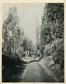
 Mt Dandenong & District Historical Society Inc.
Photograph, The Mt Dandenong Road c1930, c1930
Formed, unmade road. Possibly between Silvandale Store and FiveWays, Kalorama. Copy of Rose Series postcard # 310. (2 copies)Black and white photograph showing a road passing through trees. THE ROSE SERIES P. 310 THE MT DANDENONG ROAD VICfiveways, rose series, mt dandenong road -
 Mt Dandenong & District Historical Society Inc.
Photograph, Jeeves Coach on CRB Road at Foot of Farringdon Road Kalorama, 1920, 1920
Scene looking down Farringdon Road showing Jeeves horse drawn coach going along the CRB road (Mt Dandenong Tourist Road) in 1920. Detailed inscription on the back handwritten by John Lundy-Clarke in 1974.Jeeves Coach on CRB road at foot of Farringdon Road Kalorama (Mt Dandenong North) 1920. Road was formed most of the length from Montrose by contractors Bladin and Dick employing Robert Logan the younger, in 1919 and lay unmetalled till metalled by the contractors in 1922. Mountain ash trees in foreground were on Thomas Hand’s original 23 acre holding. Those beyond coach were on Isaac Jeeves original 160 acre holding Selection Crown Allotment 925(B). This was the area forming part of the inheritance lost by John William Richardson because of the expense of his wife’s illness. Hand enlarged his 23 acres to 305 in 1874. William and his family grew large crops of raspberries on his area, part of which is in the foreground. It had been cleared by his father’s employees before 1877. The section below the Main Road was cultivated by Fred hand, son of William and grandson of Thomas in the twenties before he moved to Redcliffes where he is today (1974). Comment by John Lundy-Clarke 10.5.1974 coach service, jeeves, crb road, farringdon road, kalorama, mt dandenong north, mt dandenong tourist road, john lundy-clarke, coach -
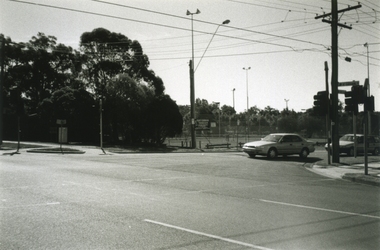
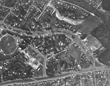 Ringwood and District Historical Society
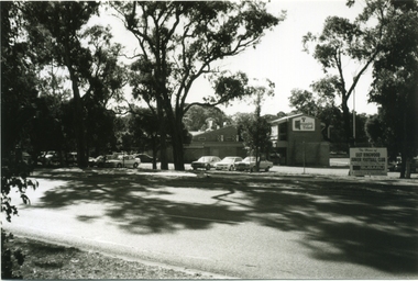
Photograph, Aerial view showing East Ringwood oval, Mount Dandenong Road, and Civic Centre, Braeside Avenue/Maroondah Hwy, c.1970
Aerial view showing East Ringwood oval, Mount Dandenong Road, and Civic Centre, Braeside Avenue/Maroondah Hwy, c.1970. -
National Vietnam Veterans Museum (NVVM)
Memorabilia, Memorabilia of Richard Keith Vines, 1966
Contains copies of his National Service call-up notices and also a copy of his honorary membership card for the RSL in Dandenong in 1970vietnam war, 1961 - 1975 -- veterans -- australia, national service - australia, 8 rar, vines, keith vines -
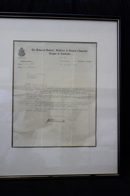 Dandenong/Cranbourne RSL Sub Branch
Document - Framed letter of thanks, The Returned, Sailors', Soldiers' & Airmen's Imperial League of Australia, unknown
RSL memorabilia Black wooden frameLetter of thanks to Mr. G. Kingsbury as President of the Dandenong Sub. Branch -
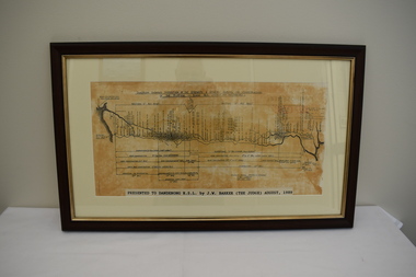 Dandenong/Cranbourne RSL Sub Branch
Map - Framed photograph, Diagram of Burma-Siam Railway
Major historical significance.Wooden framed photograph with diagram of the Railway. Illustrates the construction of the Railway. Began in October 1942 and completed on October 1943.Presented to Dandenong RSL by J. W. Barker (The Judge) August 1989. -
 Ringwood and District Historical Society
Photograph-B&W, Joan Walker, East Ringwood 2000-East Ringwood Tennis Courts and the Cnr: Mount Dandenong & Dublin Roads, 2000
East Ringwood 2000-East Ringwood Tennis Courts and the Cnr: Mount Dandenong & Dublin Roads.- B&W Photo from Album 6501 -
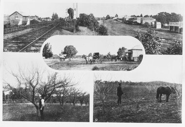 Ringwood and District Historical Society
Photograph, Photos from a Weekly Times newspaper article featuring images of early Ringwood and East Ringwood circa 1910 (6 photos), Circa 1910
Shops, houses and hotel(s) were originally regarded as being in central Ringwood and later as Ringwood East after the commercial and residential developments gradually centered further west around the Railway Station precinct after train services commencedFive photographs; Ringwood Railway Crossing; Ringwood Shopping Strip; Pruning Demonstration; Shops, houses and hotel(s) in Mount Dandenong Road; Ploughing.Written on backing sheet, "Photos from Weekly Times. Check with H.A." -
 Robin Boyd Foundation
Slide, Robin Boyd, 1965
Colour slide in a mount. Church of the Holy Eucharist, 1241 Dandenong Road, East Malvern, Victoria, Australia, 1962. (Architects: Alan Robertson and Associates.)Made in Australia / 37 / JAN 65Mmelbourne, slide -
Whitehorse Historical Society Inc.
Article, Land Which Overlooks Dandenongs, 1935
Sale of Land which overlooks Dandenongs.Land which overlooks Dandenongs : Real Estate is reviving between Box Hill and Croydon. Article on Box Hill to Croydon land development 1935.Sale of Land which overlooks Dandenongs.eastern suburbs, melbourne, real estate, transport, local government -
Whitehorse Historical Society Inc.
Letter - Correspondence, Removal of fern trees, 1870
Correspondence between David Boyle of Nunawading (Shire?) and Melbourne Botanical Gardens and an unnamed government office regarding removal of tree ferns from the Dandenongs.Correspondence between David Boyle of Nunawading (Shire?) and Melbourne Botanical Gardens and an unnamed government office regarding removal of tree ferns from the Dandenongs.Correspondence between David Boyle of Nunawading (Shire?) and Melbourne Botanical Gardens and an unnamed government office regarding removal of tree ferns from the Dandenongs.ferns, boyle, david