Showing 1913 items
matching the rock
-
 Stawell Historical Society Inc
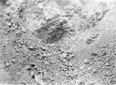
Photograph, Jubilee Open Cut Wonga Company ore body 1899
B/W photo Jubilee Open Cut - Wonga Company ore body 1899Rock wall of open cut.stawell mining -
 Lakes Entrance Historical Society
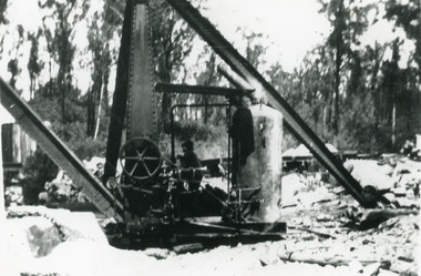
Photograph - Mississippi Creek Landing, 1930c
Black and white photograph of the steam crane used to unload rock from the tramway which brought rock from the Colquhoun quarry to the Mississippi Creek landing, placing the rock into barges for transport to the entrance at Lakes Entrance, Victoria.Steam Crane Mississippi Creek transport, historic site -
 Halls Gap & Grampians Historical Society
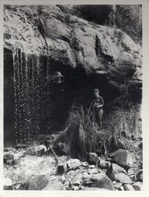
Photograph - B/W, C 1960s
Waterfall is known as Bridal Veil and is on the Wonderland/Pinnacle walk. The photo is typical of those produced by 'Victorian Railways' for tourism.Photo shows a young woman standing beside a waterfall. A rock overhang appears at top of photo with rock rubble and reeds in foreground.No.65scenery, waterfalls -
 Orbost & District Historical Society
fossil
Inspected by George Rawlings 6.2 2013.A piece of rock which is calcified vegetation.fossil -
 University of Melbourne, Burnley Campus Archives
Slide - Glass slide, 1891-1905
Arch Rock Mackinac Is.' Michigan, USA.overseas images, usa -
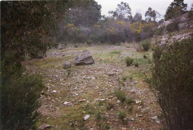
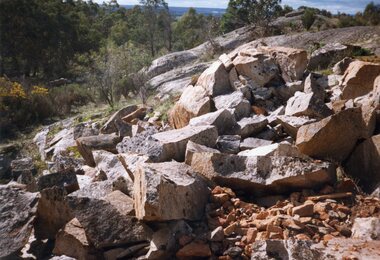 Stawell Historical Society Inc
Photograph, Don Rickard, Black Range Quarry Site, 1999
Black Range Quarry SiteOut Croppping of Rock at Quarry Sitestawell -
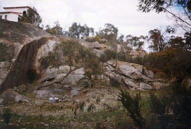
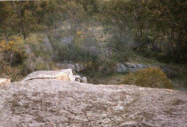 Stawell Historical Society Inc
Photograph, Don Rickard, Black Range Quarry Site, 1999
Black Range Quarry SiteOut Croppping of Rock at Quarry Sitestawell -
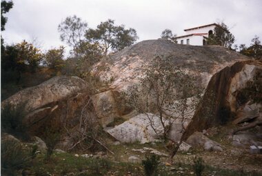
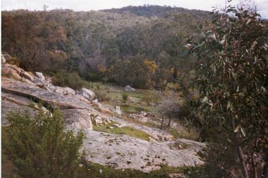 Stawell Historical Society Inc
Photograph, Don Rickard, Black Range Quarry Site, 1999
Black Range Quarry SiteOut Croppping of Rock at Quarry Sitestawell -
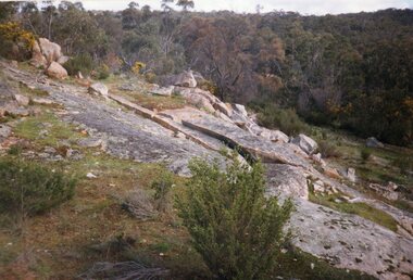 Stawell Historical Society Inc
Photograph, Don Rickard, Black Range Quarry Site, 1999
Black Range Quarry SiteOut Croppping of Rock at Quarry Sitestawell -
 Stawell Historical Society Inc
Photograph, Don Rickard, Black Range Quarry Site, 1999
Black Range Quarry SiteOut Croppping of Rock at Quarry Sitestawell -
 Stawell Historical Society Inc
Photograph, Don Rickard, Black Range Quarry Site, 1999
Black Range Quarry SiteOut Croppping of Rock at Quarry Sitestawell -
 Stawell Historical Society Inc
Photograph, Don Rickard, Black Range Quarry Site, 1999
Black Range Quarry SiteOut Croppping of Rock at Quarry Sitestawell -
University of Melbourne, Burnley Campus Archives
Photograph - Black and white print, X/27
Rock Bank from Yarra Boulevardrock bank, yarra boulevard, e. m. gibson collection -
University of Melbourne, Burnley Campus Archives
Photograph, James Leslie Provan, Burnley 1942 Album Page 1, 1942
Rock Point on left and ponds on right.rock point, ponds, burnley, 1942, j.l. provan -
University of Melbourne, Burnley Campus Archives
Photograph - Black and white print, 572/4
Constructing Rock Wall Swan Street.construction, rock wall, swan street, e. m. gibson collection -
University of Melbourne, Burnley Campus Archives
Photograph - Black and white print, 572/5
Constructing Rock Wall Swan Street.construction, rock wall, swan street, e. m. gibson collection -
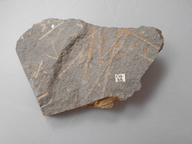 Bendigo Historical Society Inc.
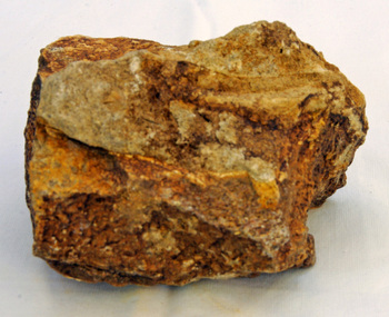
Geological specimen - GRAPTOLITE COLLECTION: ISOGRAPTUS CADUCEUS VAR. VICTORIAE HARRIS
Isograptus caduceus var. victoriae Harris Castlemanian Dark Grey rock, multiple graptolite fossils on 2 faces of rock. Sticker with 'Ca38' on rock. Fossil collection formerly held in the School of Mines Museum, Pall Mall, Bendigo. -
 Royal District Nursing Service (now known as Bolton Clarke)
Photograph - Photograph, black and white, 30 08 1967
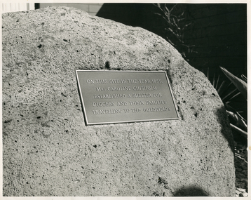
The rock and attached plaque to Caroline Chisholm stand in front of the Royal District Nursing Service (RDNS) Essendon Centre. It was unveiled at the opening of the Centre on the 30 August 1967.The plaque has a deep silver colour background, light silver colour writing with gold coloured edging.Caroline Chisholm visited the goldfields of Victoria in 1854 and was horrified by the conditions en-route. The Memorial plaque to Caroline Chisholm, in front of the RDNS Essendon Centre which is situated on Crown Land, is in recognition for her work in establishing, with Government assistance, shelter sheds about a days walk apart, to enable the prospectors and their families heading for the goldfields shelter on their way. Caroline Chisholm, a Philanthropist, began her work in Madras in 1834 founding a Female School of Industry for the daughters of European soldiers. They were taught to read, write, cook, keep house and were given instructions in nursing. After coming to Sydney in 1838, she set up accommodation for poor young unemployed migrant women and families. This work was extended when she arranged employment for assisted immigrant women and families into the countryside, many times travelling with groups of young women to check their employment conditions. In seven years she placed 11,000 people in homes and employment. On her return to England she fought for, and won, free passage to Australia for wives and children of former convicts, and for children left behind in England by circumstances, when the family migrated. She established the Family Colonisation Loan Society in 1849, which set up a saving scheme for emigrants, and later loaned them half of their passage to Australia. The Society's Agents found them employment on arrival, and the loan was paid back within two years by a humane payment scheme. At first they used emigrant ships, but then the Society provided ships with much improved conditions, and this led to the upgrading of the passenger Act.. The Chisholm's lived in Kyneton for several years, returning to Sydney for health reasons, before going back to England where Caroline died, aged 68 years, on the 25th of March 1877.Black and white photograph of the Memorial plaque to Caroline Chisholm. The rectangular plaque sits on a rough light grey rock, and has light colour writing and edging, on a dark grey background. The inscription on the plaque is in five lines and reads: "On this site in the year 1855"/, "Mrs Caroline Chisholm"/, "Established a Shelter for"/, "Diggers and their families"/ "Travelling to the Goldfields"/.Photographers stamp. Quote No. GJ 56rdns, royal district nursing service, rdns centre, caroline chisholm, memorial plaque -
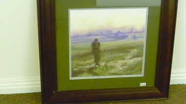 National Vietnam Veterans Museum (NVVM)
Painting, 'Back to Base'
Commemorates the war in Vietnam.Helicopter - Huey - Picture (Pastel on Board) in brown timber frame with olive green mat. Harris, Jan P.O.Box 332 Black Rock 3193helicopter - huey, vietnam, solider -
National Wool Museum
Book, An analysis of the records of the registered Australian merino stud flocks
"An analysis of the records of the registered Australian merino stud flocks"-B F Short and H B Carter, Council for Scientific and Industrial Research, Bulletin no 276, 1955.From the library /of/ Edward Mosig/ Black Rock Victoriasheep breeding merino sheep, council for scientific and industrial research new south wales sheepbreeders' association, sheep breeding, merino sheep -
Stawell Historical Society Inc
Book, Phillip Byrne, Byrne's or Burnsides Hotel Stawell's Rock of Cashell, 2019
Hotel Located on Corner of Patrick Street and Upper Clemes StreetClear Plastic Cover with black wire bindingByrne's Hotel Stawell's Rock of Cashel Phillip Byrnehotel, byrne's hotel, rock of cashel -
![Photograph - Construction of the F19 [Eastern Freeway], Ron Setford, May 1973](/media/collectors/550653872162f11fb04854aa/items/67ff9d333b378d43a2a8b6f3/item-media/67ff9d4d3b378d43a2a8b8cb/item-fit-380x285.jpg) Kew Historical Society Inc
Kew Historical Society IncPhotograph - Construction of the F19 [Eastern Freeway], Ron Setford, May 1973
Ron Setford and his wife Grace Setford lived in Tanner Avenue, East Kew, from c.1946 to c.1995. A keen photographer, he recorded the changing face of Kew over a 20 year period. Apart from 30 photographs of built structures and places in Kew dating from 1960 and 1961, 145 of his 35mm colour slides chronicle the development of the F19 (later renamed Eastern) Freeway through the Yarra Valley in Kew over a five year period from c.1972 to c.1977. This important collection was donated to the Society by his granddaughter in 2025.This collection of 175 35mm slides is of local and statewide significance, owing to its subject matter, particularly the major development of road transport infrastructure during the 1970s with the construction of the Eastern Freeway. The photographer also took care to annotate and date most of his slides which enable the researcher to pinpoint temporal and spatial locations."Eastern Freeway / Rock facing to embankment / May 73"ron setford, eastern freeway, f19 freeway -
 Halls Gap & Grampians Historical Society
Photograph - Sepia
A side vie of Silverband Falls.The photo shows a side view of a waterfall (Silverband Falls). To the right of the falls there is a rock face and in the foreground there is a large log and a rock among bracken.scenery, silverband falls -
 Victorian Interpretive Projects Inc.
Photograph - Colour, Clare Gervasoni, Mouth of the Hopkins River, Warrnambool, 2013, 22/12/2013
The Hopkins River flows through WarrnamboolFive colour photographs of Warrnambool's Hopkins River. This area, also known as Blue Hole, features ciiffs, rock formations and rock pools. warrnambool, hopkins river, mouth, blue hole -
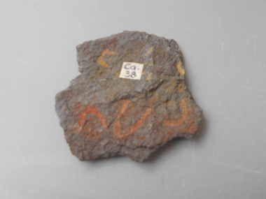 Bendigo Historical Society Inc.
Geological specimen - GRAPTOLITE COLLECTION: ISOGRAPTUS CADUCEUS VAR. VICTORIAE HARRIS
Isograptus caduceus var. victoriae Harris, Castlemainian. Dark grey rock. Four specimens on rock, largest with 2 cm stipes. Sticker with 'Ca38' on rock. Graptolite specimen was formerly held in the School of Mines Museum, Pall Mall, Bendigo. -
Bendigo Historical Society Inc.
Photograph - AUSTIN COLLECTION: Operating rock drill, Central Deborah Gold Mine, Possibly 1990's
Central Deborah Gold Mine history: At its peak, Central Deborah Gold Mine reached a depth of 412 metres. It has 17 separate levels and 15 kilometres of drives and cross cuts (tunnels). The Central Deborah was very much a hands-on mine and the conditions that the miners worked in would be considered shocking by today's standards – being lowered underground in a cage with only two sides, often working ankle to knee deep in water, filling up to 32 ore trucks a shift by hand which were then pushed a mile or more along rails in the drives, working by carbide lamp, breathing in the fumes and rock dust and communication by bells. Geez, they were ironmen. However, at the time working conditions were considered to be among the best on the goldfields at Central Deborah, after all it was one of the only mines that had hot showers. Following Central Deborah Gold Mine's closure, the Bendigo skyline began to noticeably change. Obvious remnants of mining such as poppet heads, engine rooms, service quarters, battery houses and chimneys were steadily disappearing. After intense lobbying by the local community, the Bendigo City Council purchased the still very much intact Central Deborah Gold Mine in 1970 for a mere $6,000 to ensure that a vital link to Bendigo's historic golden past was maintained. The Bendigo Trust was then formed to oversee the operations of the Central Deborah Gold Mine, which led to the surface of the mine being opened to the public in 1971. Initially the surface was open for just 12 hours a week and as the demand for viewing a part of Bendigo's history increased, so did the opening hours. In 1974 the mine was gazetted as a Public Historical Purposes Reserve and attracted such visitors as H.R.H Prince Charles. By far the greatest shortcoming at this stage was that no one could view the underground workings, as these had become flooded. After what could only be described as a monumental effort by everyone involved, Level 2 of the mine was officially opened to the public by the Premier of Victoria, the Honourable John Cain, on 20 June 1986, which brought to fruition a long standing dream.Black and white photograph. Two men with hard hats and lights standing in front of underground rock surface at Central Deborah Gold Mine. Man on left hand side of image is operating a small rock drill. Man on right hand side is observing the procedure. gold mining, central deborah gold mine, rock drill, underground -
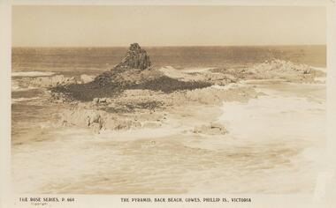 Phillip Island and District Historical Society Inc.
Photograph - Post Card, Early 1900's
Donated by Bernard GraydenSepia Postcard of Pyramid Rock surrounded by sea.The Rose Series. P. 664. The Pyramid, Back Beach, Cowes, Phillip Is., Victoria.pyramid rocks phillip island, phillip island, rock formations -
 Phillip Island and District Historical Society Inc.
Photograph, Bryant West
One of a collection of over 400 photographs in an album commenced in 1960 and presented to the Phillip Island & Westernport Historical Society by the Shire of Phillip IslandPhotograph of Rock Formation Cape Woolamai - The Elephants.local history, photography, photographs, coastline, cape woolamai, rock formations, phillip island, the elephants cape woolamai, john jenner, bryant west -
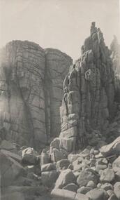
 Phillip Island and District Historical Society Inc.
Photograph, Bryant West
One of a collection of over 400 photographs in an album commenced in 1960 and presented to the Phillip Island & Westernport Historical Society by the Shire of Phillip IslandPhotograph of Rock Formation, Cape Woolamai - The Watchtower.local history, photography, photographs, coastline, cape woolamai, rock formations, phillip island, the watch tower cliffs, the watch tower cape woolamai, john jenner, bryant west -
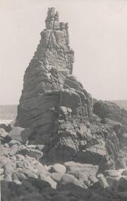
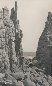 Phillip Island and District Historical Society Inc.
Photograph, Bryant West
One of a collection of over 400 photographs in an album commenced in 1960 and presented to the Phillip Island & Westernport Historical Society by the Shire of Phillip IslandPhotograph of Rock Formation - Cape Woolamai - The Pinnacles.local history, photography, photographs, coastline, cape woolamai, phillip island, black & white photograph, rock formations, the pinnacles cape woolamai, john jenner, bryant west