Showing 2474 items
matching township
-
 Kinglake Historical Society
Kinglake West township
Kinglake West corner with post office (formerly Tommys Hut) and Carman's garage on left. In the days of dirt roads.Early photograph of intersectionPhotograph of Kinglake West corner with the post office on the right and Carman's shop and garage on the left.post office, kinglake west, tommys hut, carman -
 Port Melbourne Historical & Preservation Society
Plan - Sandridge, Department of Lands and Survey, "The Township of Sandridge", 5 Nov 1860
Map of Sandridge, lithographed 1860, showing subdivisions on Evans Street, but no other development West of the railway Lihographed at the Department of lands and Survey, Melbourne 5th November 1860. Hand drawn annotations added at unknown date.Hand written "clay ground" 18 chains long, 7.5 chains broad, 26 chains from railwayengineering - roads streets lanes and footpaths, sandridge lagoon, transport - railways, town planning, local government - borough of sandridge -
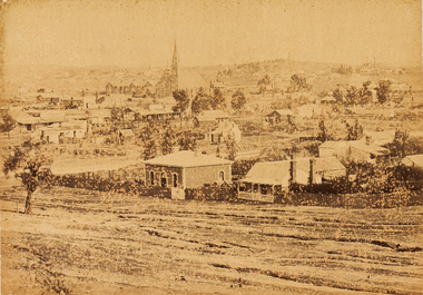 Bendigo Art Gallery
Photograph - Work on paper, Nicholas CAIRE, View of the Golden Square Township, 1875
l.l; N.J.Caireaustralian photographer, albumen, bendigo, golden square, sandhurst, town, city, skyline -
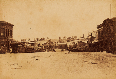 Bendigo Art Gallery
Photograph - Work on paper, Nicholas CAIRE, Township of Eaglehawk, 1875
Inscribed on original mountcard, l.l., gold letterpress, "N.J. CAIRE"eaglehawk, albumen, photograph, regional victorian. civic, roads, town, bendigo, sandhurst -
Tatura Irrigation & Wartime Camps Museum
Booklet, Kyabram The Larger Valley Township, 1989
Presented by author to Tatura Historical SocietyYellow soft cardboard cover with brown printed titletown of kyabram, books, history, local -
Tatura Irrigation & Wartime Camps Museum
Booklet, Kyabram - The Larger Valley Township, 1989
Covering the history of Kyabram from the early settlement, railways and businesses and Kyabram CanneryBeige cover, brown writing. Swirls of brown top and bottom of frontcoverkyabram early settlement, railways, kyabram businesses, kyabram cannery, tatura, books, history, local -
 Lake Bolac & District Historical Society
Colour photograph, Lake Bolac township. 1963
Crossroads at Lake Bolac, 1963. Junction of the Ballarat/Hamilton and Ararat/Mortlake roads. Starting centre left, the large building on the south-east side of the Ballarat road is Goodall's garage. Next door is the original Bush Nursing centre, then Dalgety's, the Bakery, the Milkbar and on the corner is the Bank of New South Wales building, Elder's, Green's drapery shop and the Lake Bolac Memorial Hall. On the traffic island in front of the Hall is the War Memorial and across the Woorndoo road is the Hotel (with the maroon roof) with stables behind. Across the road again is the Stanbury's General Store with their large warehouse behind.lake bolac, 1963, goodall, bush nursing, dalgety, elders, green, bank of new south wales, stanbury. -
 Inverloch Historical Society
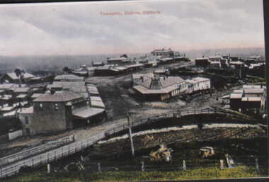
000450 Postcard - Scene of Outrim mine and township, Victoria - Should be Outtrim - Photocards by SGP Wonthaggi 5672 1749
-
 Inverloch Historical Society
000453 Postcard - Township Outrim, Victoria - Should be Outtrim - Photocards by SGP Wonthaggi 5672 1749
-
 Nillumbik Historical Society Incorporated
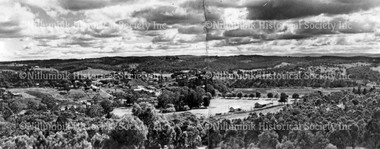
Photograph - Black & white photograph, Diamond Creek township panorama from Fraser Street 1944
-
 Nillumbik Historical Society Incorporated
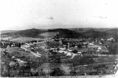
Photograph - Black & white photograph, Diamond Creek township from Fraser Street c1900
Black & white photographdiamond creek, view from fraser street, nillumbik -
 Nillumbik Historical Society Incorporated
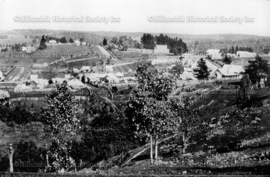
Photograph - Black & white photograph, Diamond Creek township from Ness Street c1900
-
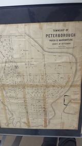 Peterborough History Group
Map - Map of the township of Peterborough, Township of Peterborough
Undated but indicative of the layout of the town. includes printed notes regarding the landscape and flora.Old map of the township of Peterborough from J S Irvine.A3 size paper map with tape around the sides. Includes handwritten notes.Handwritten on the rear is J.S Irvinepeterborough, old maps -
Stawell Historical Society Inc
Map, Stawell Gold Mines, Plan View of Township Area Showing Known Old Workings. 2003, 13/06/2003
Two AO Maps that Overlap Showing Old workings on Map of Town North of Patrick StreetScale 1 : 5000 -
Stawell Historical Society Inc
Map, Department of Crown Lands and Survey Victoria, Allotments in the Township of Banyana. Parish of Burrum Burrum. 1946 / 1971, 1971
Richardson River. Avon River JunctionPaper Map of County of BorungReprint of the 1946 edition. Drawn and reproduced at the Department of Crown Lands and Survey Victoria 1971.survey -
Stawell Historical Society Inc
Map, Stawell Gold Mines, Stawell Township proposed Town zoning showing Special Uses ( Mining) 1998, 1998
Shows Mining activity Stockpiles Tracks, Plant, Dams, Waste heap, Tailing Dams, IronbarksMap Printed in Colour with Coloured LegendStawell Gold Mines Pty Ltd Date April 1998mining -
Stawell Historical Society Inc
Map, Stawell Gold Mine, Stawell Gold Mine Photo Map of Stawell Township showing Underground Declines in mining lease, 2007
SGM photo Map 2007 Produced for Public Consultation over Big Hill Open Pit Proposal. Aerial Views Stawellmining, gold, map -
Stawell Historical Society Inc
Map, MPI Mines, Plan View of Township Area 2003, 13/6/2003
goldShowing known gold workings & Houses Stawell Gold Mines. 13 June 2003 1 : 7500 MPI Minesmining -
Stawell Historical Society Inc
Map, MPI Mines, Plan View of Township Area 2003, 13/6/2003
goldShowing known old gold workings Stawell Gold Mines. 13 June 2003 1 : 7500 MPI Minesmining -
Stawell Historical Society Inc
Map, Stawell Gold Mine, Tenement Boundaries Stawell Township 2001, August 2001
Showing Underground Development Stawell Gold Mines Victoria Scale 1 : 20000mining, gold -
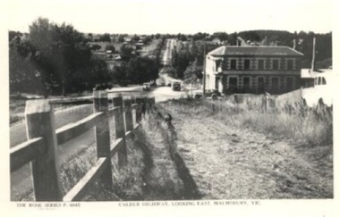
Malmsbury Historical Society
Photograph (Item), "Malmsbury Township, Daffodil Plantation", Malmsbury c1991
Associated with - "M.H.S., M.A.A." Buildings - Taken From Barker St -
![Photograph (Item), Township Of Malmsbury (1879) [Duplicate Entry], Malmsbury ca1990](/media/collectors/510b3f7f023fd725b4cd52a4/items/60062caeff312d11a81298e4/item-media/60062d78ff312d11a812b31d/item-fit-380x285.jpg) Malmsbury Historical Society
Malmsbury Historical SocietyPhotograph (Item), Township Of Malmsbury (1879) [Duplicate Entry], Malmsbury ca1990
People - "Williamson, Florence" -
 Malmsbury Historical Society
Postcard (Item), "Postcard Township Of Malmsbury, Rose Series P4845", Malmsbury c1938
Associated with - Rose Series P4845 Buildings - The Mansions -
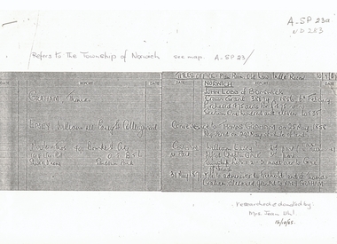 Whitehorse Historical Society Inc.
Document, Township of Norwich, C1860
List of names from Titles OfficeList of names from Titles Office concerning proposed Norwich Village Vermont 1850sList of names from Titles Officeland titles, norwich village, vermont, graham, thomas, easey, william, moule, lobb, john, gale, alfred chaplin -
Whitehorse Historical Society Inc.
Document, Blackburn Township Estate, 1906
110 business and residential sites for sale.110 business and residential sites for sale, Saturday 6th October 1906. Stamped by T.R.B. Morton, Financial and Estate Agent, 80 Swanston St. Melbourne.110 business and residential sites for sale.blackburn township estate, morton, thomas richards burrowes, haughton maps -
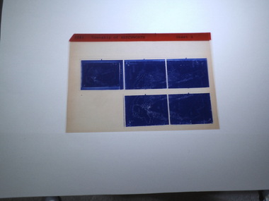
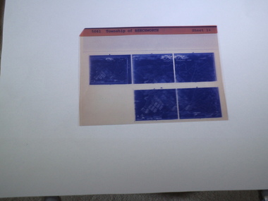 Rutherglen Historical Society
microfich sheet, Victorian Land Tiltes Office, Township of Beechworth
Town layout of Beechworth5 Aperture Sized microfilms on a single microfiche in a paper sleeve plan, town, boundries, lots, roads -
 Rutherglen Historical Society
microfiche sheet, Victorian Land Tiltes Office, Township of Beechworth
Town layout of Beechworth5 Aperture Sized microfilms on a single microfiche in a paper sleeve plan, town, boundries, lots, roads -
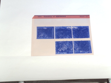 Rutherglen Historical Society
microfiche sheet, Victorian Land Tiltes Office, Township of Beechworth
Town layout of Beechworth5 Aperture Sized microfilms on a single microfiche in a paper sleeve plan, town, boundries, lots, roads -
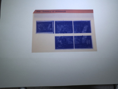 Rutherglen Historical Society
microfiche sheet, Victorian Land Tiltes Office, Township of Rutherglen
Town layout of Beechworth5 Aperture Sized microfilms on a single microfiche in a paper sleeve plan, town, boundries, lots, roads -
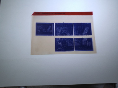 Rutherglen Historical Society
microfiche sheet, Victorian Land Tiltes Office, Township of Rutherglen
Town layout of Beechworth5 Aperture Sized microfilms on a single microfiche in a paper sleeve plan, town, boundries, lots, roads