Showing 331 items
matching victoria quartz
-
 Bendigo Historical Society Inc.
Administrative record - South New Chum Syncline Gold Mine Labour Covenants suspension, 1936
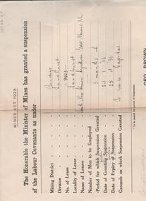
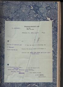
... as the Victoria Quartz. Lansell’s Big 180, North Old Chum and New Chum... as the Victoria Quartz. Lansell’s Big 180, North Old Chum and New Chum ...South New Chum Syncline South New Chum Syncline Gold Mines, N.L., has been floated with a capital of £27,500 in 55,000 shares of 10/ each. Forty thousand have been issued at 1/,10,000 fully paid shares go to vendors, and 5000 will be held in reserve. - Messrs. Savage and Nicholas report that the issue was heavily over-subscribed. The property is situated in the central portion of the Bendigo field, adjoining such former producers as the Victoria Quartz. Lansell’s Big 180, North Old Chum and New Chum. (Bendigo Advertiser, 29th September 1932).Two documents from Department of Mines, 25th January, 1936. 'Cover letter, addressed to McColl, Rankin and Stanistreet, Commonwealth Bank Chambers, Charing Cross, Bendigo, informs 'that the Honorable the Minister has granted a suspension of the Labour Covenant of Lease No. 9903 Bendigo ...expiring on 25th April, 1936. Suspension is for the Mining District of Bendigo, division Sandhurst, No. of lease 9903 for 3 months from 24.1.36 to 25.4.36. Document is part of the Margaret Roberts Collection of mining records. bendigo, gold mining, south new chum syncline gold mine, j.j. stanistreet, legal manager, margaret roberts collection, labour convenant -
 Bendigo Historical Society Inc.
Administrative record - South New Chum Syncline Gold Mines N.L. Minute Book, 1932 - 1940
... as the Victoria Quartz. Lansell’s Big 180, North Old Chum and New Chum... as the Victoria Quartz. Lansell’s Big 180, North Old Chum and New Chum ...South New Chum Syncline South New Chum Syncline Gold Mines, N.L., has been floated with a capital of £27,500 in 55,000 shares of 10/ each. Forty thousand have been issued at 1/,10,000 fully paid shares go to vendors, and 5000 will be held in reserve. - Messrs. Savage and Nicholas report that the issue was heavily over-subscribed. The property is situated in the central portion of the Bendigo field, adjoining such former producers as the Victoria Quartz. Lansell’s Big 180, North Old Chum and New Chum. (Bendigo Advertiser, 29th September 1932).Green hard cover book, maroon binding on spine, 284 pages of which 94 are used. 'Minute Book' on front cover. Written in pencil across top of name ' South New Chum Syncline'. Inside front cover affixed to page, document 'Registrar-General re Notice of Office and of Manager, filed 23.10.32 in connection with South New Chum Syncline Gold Mines N.L. Minutes in book date from 5th October 1932 to 23rd August 1935. First minutes of meeting describes the Company as having 55,000 shares of ten shillings each. Final two pages have documents affixed that relate to the closure and sell-off of the free-hold property and mine equipment in 'Happy Valley Road, Bendigo for the sum of not less than Two Hundred and fifty pounds and that out of the proceeds thereof the following amounts be paid', An amount of 120 pounds, thirteen shillings and two pence are listed. Minute Book is part of the Margaret Roberts Collection. bendigo, gold mining, south new chum syncline gold mine, j.j. stanistreet, legal manager, margaret roberts collection, -
 Clunes Museum
Photograph, CLUNES IN THE 1860'S
... PRINT - VICTORIA QUARTZ MINING COMPANY, REGISTERED, CLUNES .6... COMPANY, CLUNES .5 PHOTO PRINT - VICTORIA QUARTZ MINING COMPANY ...CRITERION. QUARTZ MINING COMPANY REGISTERED CLUNES VIEW IN TOWNSHIP, CLUNES, SOUTH EAST CAMP PARDE, CLUNES, SOUTH WEST PORT PHILLIP AND COLONIAL GOLD MINING COMPANY, CLUNES VICTORIAN QUARTZ MINING COMPANY, REGISTERED CLUNESCLUNES IN THE 1860S FIVE VIEWS BY CHARLES NETTLETON .1 LARGE ENVELOPE WITH DESCRIPTIONS OF EACH OF THE PHOTOS. PUBLISHED BY SHIRE OF TALBOT AND CLUNES FROM ORIGINAL PHOTOGRAPHS. .2 PHOTO PRINT - VIEW IN TOWNSHIP, CLUNES, SOUTH EAST .3 PHOTO PRINT - CAMP PARADE, CLUNES, SOUTH WEST .4 PHOTO PRINT - PORT PHILLIP AND COLONIAL GOLD MINING COMPANY, CLUNES .5 PHOTO PRINT - VICTORIA QUARTZ MINING COMPANY, REGISTERED, CLUNES .6 PHOTO PRINT - CRITERION QUARTZ MINING COMPANY, REGISTERED. CLUNESC. NETTLEFOLD, PHOTO, MELBOURNElocal history, photography, photographs, mining, clunes in the 1860's five views by charles nettlefold -
Bendigo Historical Society Inc.
Document - VICTORIA HILL - VICTORIA HILL IRONBARK
... , Cinderella Mine, Lansell's 180, North Old Chum, Victoria Quartz..., Cinderella Mine, Lansell's 180, North Old Chum, Victoria Quartz ...Typed copy of notes on Victoria Hill, Ironbark and New Chum Hill - An Historic Landmark. Notes include locality, some of the early mines, their depth, gold produced, dividends paid, vertical winding engine and crushing battery. Mines mentioned are: Rae's, Wittscheibe and Company 'Jeweller's Shop', the Advance, Cinderella Mine, Lansell's 180, North Old Chum, Victoria Quartz, Burrowes and Sterry's, Lazarus' Claim, Gibbs and Lazarus, Bonatti's, Menzies, Hildebrandt and Kock's, Ellesmere, Old Chum, New Chum and Victoria, New Chum United, New Chum Consolidated and the Garibaldi.document, gold, victoria hill, victoria hill, victoria hill ironbark, rae's, wittscheibe and company 'jeweller's shop', hopetoun band room, advance, cinderella mine, geo lansell, lansell's 180, new chum hill, fortuna mansion, new chum drainage association, north old chum, b c v 8 television studio, royal survey regiment, burrowes and sterry, lazarus claim, gibbs and lazarus, bonatti's, menzies, hildebrandt and kock's, ellesmere, old chum, p m g repeater station, ballerstedt, mr geo lansell, new chum and victoria, phoenix, mt alvernia hospital, new chum united, new chum consolidated, garibaldi, mr clarke magee -
 Bendigo Historical Society Inc.
Administrative record - South New Chum Syncline Gold Mines Share Transfer Journal, 1934 to 1939
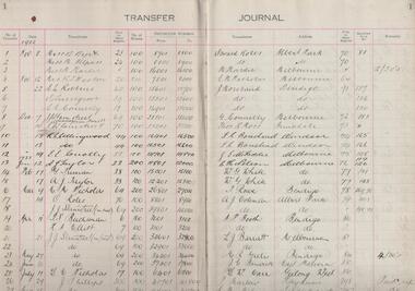
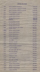
... such former producers as the Victoria Quartz. Lansell’s Big 180, North... such former producers as the Victoria Quartz. Lansell’s Big 180, North ...South New Chum Syncline (The Sun News-Pictorial (Melbourne, Vic. : 1922 - 1954; 1956) Thu 29 Sep 1932 ) Page 21: 'South New Chum Syncline Gold Mines,N.L., has been floated with a capital of £27,500 in 55,000 shares of 10/ each. Forty thousand have been issued at 1/, 10,000 fully paid shares go to vendors ,and 5000 will be held in reserve. -Messrs. Savage and Nicholas report that the issue was heavily over-subscribed. The property is situated in the central portion of the Bendigo field, adjoining such former producers as the Victoria Quartz. Lansell’s Big 180, North Old Chum and New Chum'.Black cover, red spine, fifty page journal. Written on front cover in black text on white background 'Transfer Journal' Purple stamp above 'Transfer Journal' 'South New Chum Syncline Gold Mines' . Entries detail the transferror, page in share register, number of shares, distinctive numbers, transferee, address, folio in share register, cancelled script number and remarks. Entries date from November 3rd. 1932 to June 27th 1939. Journal is part of the Margaret Roberts Collection. bendigo, gold mining, shareholders, share transfers, south new chum syncline gold mines, new chum line of reef -
 Bendigo Historical Society Inc.
Document - ALBERT RICHARDSON COLLECTION: VICTORIA HILL IRONBARK
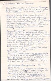
... 180 Mine, Victoria Quartz Mine; Wittscheibe's 'Jewellers Shop... on Victoria Hill; Lansell's Big 180 Mine, Victoria Quartz Mine ...Three page handwritten document outlining the history of the Victoria Hill area. The open cuts on Victoria Hill; Lansell's Big 180 Mine, Victoria Quartz Mine; Wittscheibe's 'Jewellers Shop', Luffman and Sterry, Central Nell Gwynne and New Chum Hill are mentioned in the article. A description of the suitability of the Victoria Hill site as a potential mining museum is discussed as 'it is centrla to both the northern and southern ends of the main portion of the Bendigo and Eaglehawk mines'. William Rae built two fine residences on Happy Valley Road, and also set up a 30 head battery out of his gains from Victoria Hill.bendigo, mining, victoria hill -
 Bendigo Historical Society Inc.
Document - ALBERT RICHARDSON COLLECTION DEEP MINES ON THE BENDIGO FIELD
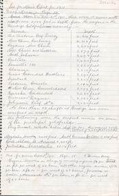
... , The Victoria Quartz 4614 feet, New Chum Railway 4318 feet, Lazarus New... of mines and depths, The Victoria Quartz 4614 feet, New Chum ...One page document titled ' Secretary for Mine's Report for 1911, Deep Mines page 24. List of mines and depths, The Victoria Quartz 4614 feet, New Chum Railway 4318 feet, Lazarus New Chum 3682 feet, New Chum and Victoria 3579 feet, North Johnson's 3498 feet, Carlisle 3460 feet, Lansell's 180 3365 feet, Clarence 3310 feet, Great Extended Hustlers 3290 feet, Ironbark 3250 feet, Victoria Consols 3114 feet, New Chum Consolidated 3099 feet, Eureka Extended3060 feet, Princess Dagmar 3020 feet, Johnsons Reef No 2 2020 feet.bendigo, mining, deep mines on the field -
Bendigo Historical Society Inc.
Book - VICTORIA HILL - VICTORIA HILL BENDIGO
... Booklet titled: 'Victoria Hill Bendigo A Publication... in the 1870's, compressor beds, The victoria Quartz Mine, burnt ground ...Booklet titled: 'Victoria Hill Bendigo A Publication of the Bendigo Trust'. Booklet has photos of the Central Nell Gwynne Mine, Victoria Hill in the 1860's, with Rae's Battery in the foreground, geographical features, Rae's Open Cut, Victoria Hill from the New Chum Hill in the 1870's, compressor beds, The victoria Quartz Mine, burnt ground from quartz roasting, the remains of a twenty head crushing battery, a view from Ballerstedt's Open Cut showing the historic Gold Mines Hotel built in 1857 and the engine beds of Lansell's '180' mine. There are also two maps, History of Victoria Hill and geographical notes on the area.book, bendigo, victoria hill, victoria hill, victoria hill bendigo -
 Bendigo Historical Society Inc.
Document - ALBERT RICHARDSON COLLECTION: EARLY HISTORY OF THE BENDIGO GOLDFIELD
... by the Victoria Quartz Company. About 100 shafts exceed a depth of 1,000... by the Victoria Quartz Company. About 100 shafts exceed a depth of 1,000 ...Typed foolscap two sided document with information about the early history of the Bendigo Goldfield. Topics include the first gold discovery, how gullies were worked, quartz reefing, gold cakes, hand dollies and Chilian mills. Some brief statistics of the Bendigo goldfield include the total gold yield of 17,370,561 ounces plus 5,000,000 oz sold outside Bendigo. The greatest depth reached by any mine in the State, 4,593 feet below surface, or 3,700 feet below sea-level, was attained by the Victoria Quartz Company. About 100 shafts exceed a depth of 1,000 feet, of which 40 are between 2,000 and 3,000 feet deep, fifteen are between 3,000 and 4,000 feet and two are over 4,000 feet.bendigo, mining, mines department -
 Bendigo Historical Society Inc.
Document - PREMIER COMPANIES (GOLD MINING)
... Devonshire, Old Chum, Victoria Quartz, North Johnson's, Johnson's... Devonshire, Old Chum, Victoria Quartz, North Johnson's, Johnson's ...Document. 2 page typed document titled 'Premier Companies'. Lists various mining companies from 1870 to 1920 and the amount in pounds that each mine yielded. Mentions mines - Great Extended Hustlers, Great Extended Hustlers Tribute, Garden Gully United, Victory, Pandora, United Hustlers, Redan Garden Gully, United Devonshire, Old Chum, Victoria Quartz, North Johnson's, Johnson's Reef, New Red White and Blue, New Chum United, Lady Barkly, New Chum Railway, Great Southern, South New Moon, New Argus, Virginia, Central Red White and Blue, New Chum Goldfields, Victoria Consols, Carlisle, Hercules and Energetic, New Golden Fleece, Bendigo Amalgamated Goldfields.cottage, miners, premier companies (mining), bendigo mines -
 Bendigo Historical Society Inc.
Photograph - VIEWS OF BENDIGO: NORTH OLD CHUM CLAIM, c. 1870's
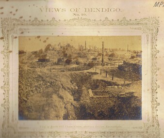
... Chum and Victoria Company's Quartz Crushing Battery... No. 180 Claim, Welch Expo. 'New Chum and Victoria Company's Quartz ...Photograph 10. Sepia photograph of View of North Old Chum Claim, showing surface Excavations. Printed below photograph: J.W. Forbes, Agent, Lansell's No. 180 Claim, Welch Expo. 'New Chum and Victoria Company's Quartz Crushing Battery', 'the dividing range between Happy Valley, Victoria Hill and Iron Bark'. Nicholas CaireN J Cairetopic, mining, old chum mine -
 Bendigo Historical Society Inc.
Document - BENDIGO AND VICTORIA HILL REPORT ON GEOLOGY
... Victoria, Victoria Quartz, Lansells 180, North Old Chum. Maps...; Victoria Consols, Great Central Victoria, Victoria Quartz, Lansells ...Report, 8 pages, on the geology of Bendigo district and Victoria Hill, produced by the Geological Survey Dept., Victorian Government. G.J. Medwell, Geologist. 19.10.1967. On front 'Geological Survey of Victoria. Mines Department Victoria. Report on Geology of Bendigo and of Victoria Hill Area' Letter attached inside front cover to J.C.Balfour, Minister of Mines to G.A. Lambert, Liberal Party, Sunshine, Victoria, sent with book for his information. Report contains: Cobaw batholith and North Harcourt Bendigo goldfield generally Trought, reefs, saddles and spurs Victoria Hill mines; Victoria Consols, Great Central Victoria, Victoria Quartz, Lansells 180, North Old Chum. Maps attached show part of New Chum line of reef and a handdrawn map of Rae's Cutting.bendigo, mining, victoria hill, bendigo goldfield -
 Bendigo Historical Society Inc.
Document - THE BENDIGO GOLDFIELDS - A FEW FACTS, c1970
... United in Golden Square, The Victoria Quartz in Victoria Hill... Quartz in Victoria Hill Ironbark, The United Devonshire Mine ...Document. A Few Facts (7 copies). Two page typed, timelined document on the Goldfield area of Bendigo 1851 1954 by the Bendigo Branch of the Royal Historical Society of Victoria. Mentions Ravenswood sheep run, German Gully, Derwent Gully, Peg Leg Gully, 'The Dascombe' & 'The Victoria' gold nuggets. Watson's Kentish mine in Long Gully, Garden Gully United in Ironbark, The Great Extended Hustlers Tribute on Hustlers Hill, The New Chum United in Golden Square, The Victoria Quartz in Victoria Hill Ironbark, The United Devonshire Mine in Eaglehawk, The Famous Devonshire Valley, Portion of the New Chum Group in Golden Square, The New Moon, The South New Moon, The 'Flying Fox' which conveyed the quartz from the Central Red, White and Blue mine to New Chum Hill, Lansell's'222' Mine, The Mine in the Heart of the City, The Fortuna Hustlers Mine; Snob's Hill, Sailors Gully & Devonshire Gully at Eaglehawk, California Gully, Long Gully, Victoria Hill at Ironbark, New Chum Hill & New Chum Valley at Golden Square, Hustlers Hill & Comet & Redan Hills at North Bendigo.cottage, miners, the bendigo goldfields, a few facts -
 Bendigo Historical Society Inc.
Document - LONG GULLY HISTORY GROUP COLLECTION: 1852 - 1950'S
... Big 180, Ballerstadt's Open-Cut, and the Victoria Quartz Mine...., and the Victoria Quartz Mine. Document LONG GULLY HISTORY GROUP COLLECTION ...Two hand written pages with year dates and what took place at that time. Dates range from 1852 to 1950's. 1950's - mining stopped in Long /G. 1926 - First Teachers training College established. Taylor Horsefields Engineering works - Horsefield a genius. Pioneered local production of compressed air driven roak-drills, specialized in rock bores and drills exported them throughout the world. Harvester - for f/ter in Harvest equipment. 1856 - Anglican School opened held church as well as school. Manchester Arms, Admiral Arms both has pretentious music halls attracted large crowds. 1862 - Ironbark, Long Gully sought annexation by the Municipality of Sandhurst. 1872 - Long Gully Fire Brigade was formed. Keen rivals. 1850 - recognised Chinese camp. ? Long Gully - due to the sinking deeper and the rewards generally richer, became the heart of 'Little Cornwall' - Cornish people. * Tent Church services held in 1862. Long Gully Mine opened April 1852. On the back of the first page is written - Mines - Reefs. mines mentioned are New Chum Hill, the New Chum and Victoria, The Victoria HIll Ironbark, The North Old Chum, Lansell's Big 180, Ballerstadt's Open-Cut, and the Victoria Quartz Mine.bendigo, history, long gully history group, the long gully history group - 1852 to 1950's, first teachers training college, taylor horsefields engineering works, anglican school, manchester arms, admiral arms, municipality of sandhurst, long gully fire brigade, chinese camp, little cornwell, long gully mine -
 Bendigo Historical Society Inc.
Map - GUIDE MAP OF BENDIGO & EAGLEHAWK, Late 1920's
... at 82,000,000 pounds. Deepest mines - Victoria Quartz 4,614 ft., New... - Victoria Quartz 4,614 ft., New Chum Railway 4,318 ft. 13 mines over ...Map. Guide Map of Bendigo & Eaglehawk. Light brown coloured booklet containing folded map of Bendigo and Eaglehawk. Outer cover is printed in blue and red ink and states - With compliments of J H Curnow & Son, Auctioneers, Real Estate Agents, Farm & Dairy Produce Merchants, Bendigo. Printed by J B Young, Lithographer. Map shows tramways & bus routes. Map shows Agricultural Showgrounds located between Park Street, Water Street, Barnard Street and Bridge Lane. Also shows Acclimitization Reserve located behind The Botanical Gardens at White Hills. Shows the location of Sailors Gully, Peg-Leg Gully, Jobs Gully, California Gully, Long Gully, Ironbark Gully, Golden Gully, Poverty Gully, Sheepshead Gully, Charcoal Gully, Eaglehawk Creek, Bendigo Creek and Back Creek. Contains interesting facts about Bendigo - Area 7,900 acres. Population - 26,000. First Council elected - 1855. Proclaimed a Borough - 1863. Proclaimed a City - 1871. Gold Rush broke out - 1851. For first 10 years gold yield averaged 8,600 ozs. per week . Total gold yield to 1923 - 572 tons valued at 82,000,000 pounds. Deepest mines - Victoria Quartz 4,614 ft., New Chum Railway 4,318 ft. 13 mines over 3.000 ft. deep. 53 mines over 2,000 ft. deep. Sewering of City commenced 1922, all principal buildings now sewered. Map printed by Arnall & Jackson, General Printers, Stationers & Engravers, 476 Collins Street. Map displays advertisement for J H Curnow & Son, Bendigo's leading Auctioneer and Estate Agents, Mitchell & Queen Sts. Bendigo. Map Scale 20 chs. = 1 in.cottage, miners, guide map of bendigo and eaglehawk -
 Bendigo Historical Society Inc.
Map - GUIDE MAP OF BENDIGO & EAGLEHAWK, Late 1920's
... valued at 82,000,000 pounds. Deepest mines - Victoria Quartz... at 82,000,000 pounds. Deepest mines - Victoria Quartz 4,614 ft., New ...Map. Guide map of Bendigo & Eaglehawk. Folded map of Bendigo & Eaglehawk with blue outer cover booklet. Map is compiled by E E Parker, Eaglehawk. Map shows tramways, bus routes and cost one shilling. Map shows Agricultural Showgrounds located between Park Street, Water Street, Barnard Street and Bridge Lane. Also shows Acclimitization Reserve located behind the Botanical Gardens at White Hills. Shows the location of Sailors Gully, Peg-Leg Gully, Jobs Gully, California Gully, Long Gully, Ironbark Gully, Golden Gully, Poverty Gully, Sheepshead Gully, Charcoal Gully, Eaglehawk Creek, Bendigo Creek and Back Creek.Contains interesting facts about Bendigo:- Area - 7,900 acres, Population - 26,000, First Council elected - 1855, Proclaimed a City - 1871. Gold Rush broke out - 1851. For first 10 years gold yield averaged 8,600 ozs. Per week. Total gold yield to 1923 - 572 tons valued at 82,000,000 pounds. Deepest mines - Victoria Quartz 4,614 ft., New Chum Railway 4,318 ft., 13 mines over 3,000ft. deep, 53 mines over 2,000 ft. deep. Sewering of City commenced 1922. All principal buildings now sewered. Map printed by Arnall & Jackson, General Printers, Stationers & Engravers, 476 Collins Street. Outer map blue cover printed in red and blue ink by J B Young, Lithographer. Map displays advertisement for Bendigo Timber Co. Outer blue cover displays advertisement for Campbell Connelly & Co. Pty. Ltd, Ironmongers, Timware Manufacturers, Plumbers, Sewerage Contractors, High and Forest Sts, Bendigo 9outside back cover) and for Hartleys ( J L Shoosmith) Bendigo, displaying Indian Motor Cycles (inside back cover).map, bendigo, township, guide map of bendigo & eaglehawk -
 The Beechworth Burke Museum
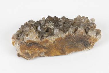
Geological specimen - Smoky quartz crystals, unknown
... , including Beechworth in Victoria. Other places quartz can be found..., including Beechworth in Victoria. Other places quartz can be found ...Quartz is an extremely common mineral to find across the world. Quartz can have two forms; Microcrystalline quartz or Crystalline quartz. Microcrystalline quartz is a fine grain quartz where crystalline quartz is often a large crystal. This specimen is a crystalline quartz. Made of silicon oxide, this specimen is called smokey quartz crystals because of its brownish colour. However, the colour of quartz can vary. In addition, quartz are formed in deep-seated igneous rocks and crystallized through hot aqueous solutions. This type of crystal can be found all over Australia, including Beechworth in Victoria. Other places quartz can be found is the Ashburton River area in Western Australia, Marlborough in Queensland, the Lune River area in Tasmania and Kingsgate in New South Wales. This specimen is significant because it is common to find this kind of mineral. While the location of where this specimen was originally from is unknown, it highlights the many places in Australia where quartz is found. It demonstrates that quartz makes up a large portion of Australia's geology. In addition, quartz itself can vary in its colour and shape. This specimen represents one of these variations. That being smoky quartz crystals. This specimen is part of a larger collection of geological and mineral specimens collected from around Australia (and some parts of the world) and donated to the Burke Museum between 1868-1880. A large percentage of these specimens were collected in Victoria as part of the Geological Survey of Victoria that begun in 1852 (in response to the Gold Rush) to study and map the geology of Victoria. Collecting geological specimens was an important part of mapping and understanding the scientific makeup of the earth. Many of these specimens were sent to research and collecting organisations across Australia, including the Burke Museum, to educate and encourage further study.A large hand-sized quartz mineral with shades of brown and gray throughout.Smoky quartz / crystals /locality/ unknown / (needs a wash) /BBgeological specimen, geology, geology collection, burke museum, beechworth, microcrystalline, quartz, quartz mining, quartz reefs beechworth, smokey quartz crystals, crystals, crystalline, silicon oxide, brown, colour, igneous rocks, magma, ashburton river, western australia, marlborough, queensland, lune river, tasmania, kingsgate, new south wales, nsw -
 Bendigo Historical Society Inc.
Photograph - Victoria Hill, Bendigo, 1973
... . Victoria Hill Quartz Gold Mines are registered as a site.... Victoria Hill Quartz Gold Mines are registered as a site ...Gold was discovered on Victoria Hill in 1854 and by 1861, 1,200,000 ounces of gold had been extracted from the site. The first claim was bought for 80 pounds by Prussian immigrant Christopher Ballerstedt and his son Theodore. Christopher Ballerstedt was nicknamed the "Father of the Hill" and was the first to prove that gold reefs extended below the surface. His 200-foot plus mine shafts yielded quartz rich with gold, inspired other miners, and were instrumental in Bendigo becoming the world's deepest and richest goldfield. The site still features relics of nineteenth century mining including quartz crushing machinery and the foundations of George Lansell’s 180 mine. These features are characteristic of Bendigo’s mining history and represent two prominent nineteenth century miners, Christopher Ballerstedt and George Lansell, who held important roles in the development of Bendigo. Victoria Hill Quartz Gold Mines are registered as a site of significance. The site is of historical, archaeological and scientific importance to Victoria. The mines represent the symbolic heart of Bendigo’s gold mining history and the importance that mining played in wealth creation and the development of Victoria. The diggings reserve is accessed from the rear of Albert Richardson Reserve located at 40-56 Marong Road, Ironbark. The site has steep and unformed paths and is closed to the public at dusk. It is important to stay to the paths to avoid the diggings. Interpretive signs help visitors to appreciate the importance of the site and the remaining relics of Bendigo’s mining history.Victoria Hill Ironbark, Bendigo. Photos of the poppet head, sand heap, tailings, shafts and tunnels. Before development into a tourist attraction.history, bendigo, victoria hill, ironbark, diggings -
 Federation University Historical Collection
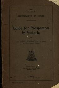
Book, Guide for Prospectors in Victoria, 1931, 1931
... of a portion of Victoria showing auriferous areas and mineral... quartz reefs alluvial deposits indicators victorian goldfields ...The handbook was intended for those with little experience who wanted to prospect of fossick.Grey soft covered book of 90 pages. Includes fold out map of a portion of Victoria showing auriferous areas and mineral localities. Also show Counties of Victoria and localities of minerals such as tin, antimony, copper, silver lead, Malybdenite, tungsten ores, manganese, platinum, osmiridium and iron. Chapter heading s include: working alluvial deposits, equipment, geology of Victoria, gold deposits, quartz reefs, indicators, economic minerals, assistance to prospectors, Miners' Right, mining bye-law, mining leases, forest regulations and glossary. Descriptions are given of a god dish, puddling tub, cradle, puddling machine, ground sluicing, boring, windlass, whim, hand dollying, sweeping, California pump, and wing dam.mining, baragwanath, gold, prospector, geology, quartz reefs, alluvial deposits, indicators, victorian goldfields, miners rights, mining leases, forest regulations, sluicing, sluice box, puddling machine, miner's cradle, whim, whip, california pump, gold nuggets, saddle reef, ballarat indicators, state batteries -
 Bendigo Historical Society Inc.
Document - LANSELL RELATED DOCUMENTS
... ., Victoria Consolidated Co., Great Central Victoria Co., Victoria...., Victoria Consolidated Co., Great Central Victoria Co., Victoria ...Document.Copy of Williamstown Historical Society Newsletter No 17 (1977).On the second and third page of this Newsletter is an article entitled ''The guns of the 'Nelson''', written by Doug Mills, Castlemaine. The Warship NELSON underwent alterations in 1860, including cut down to two decks and lengthened, her armaments reduced to 72 guns. Two 7inch 68 pounder guns were added to her armament. In February 7 1867 she was officially given to the Colony of Victoria by the Imperial Government. At the time her Commander was Captain Charles B. Payne. The Warship reached Melbourne in 4th February 1868. Relics of the NELSON were auctioned at Williamstown Victoria Naval Depot, and her two anchors are preserved for public display at Williamstown. An active demand for a share of the guns from various towns in the State. Ballarat received four (4) guns, Bendigo and Castlemaine two (2) each, while one has been given to each of the following towns: - Ararat, Tarnagulla, Hamilton, Bacchus Marsh, Echuca and Geelong. Collection of Lansell related documents: a. Copy of photograph - Lansell's Big 180 Victoria Hill - early 1870s - New Chum Hill in background. B. Lansell Estate mines - compiled from the annual report of the Hon Minister of Mines for Victoria, 1906. A listing of the George Lansell Mining Company interests at the time of his death. These were, New Moon Co, N.L., Clarence, New Prince Of Wales Co. N.L., Virginia G. M. Co., Catherine Reef United Co N.L., Great Northern Co N.L., Williams United, McDuff Amalgamated Co, South Mungo Co, South Prince Of Wales Consolidated, Constellation Co. Golden Pyke Co, Johnson's Reef Extended Company, Golden Age Co., Princess Dagmar Co, New St Mungo Co, Johnson's Reef Co, North Johnson's Co, Collman and Tacchi Co, Confidence Extended Co, G. Lansell Sandhurst Mines, Pearl Co., Windmill Hill Co., United Hustlers and Redan, Koch's Pioneer Co., Hercules and Energetic Co., Lansell's Comet, Cornish United Co., Ironbark Co., Hustler's Reef Co., and No. 1 Lansell's 83, Carlisle Co., Great Extended Hustler's Co., Victoria Consolidated Co., Great Central Victoria Co., Victoria Quartz Co., Victory and Pandora , Lansell's Big 180, Tambour Major, New Chum and Victoria Co., Garden Gully United Co., G. Lansell, Lansell's 222, Lazarus Co., Sea Amalgamated Co., Hustler's Royal Reserve Co., Horwood and Burrowe's Co., New Chum Consolidated Co., G Lansell's Sheepshead, Gariboldi Co., Londonderry Co., Shamrock Co., Great Britain Co., Fortuna Hustler's Co., Eureka Extended Co., G. Lansell's G.V.L., New Red White and Blue Consolidated, Great Southern Co., Lansell's Concord Mines, True Blue Co., G. G. Consolidated Co., Extended Red White and Blue Co., Great Columbian, Sedgwick and New Birthday. Also, a listing: ''Among the biggest yields to ate (sic) (date?) in ozs or Pounds were''; New Moon.Co. N.L. 180,087 ounces, Clarence £303,932, Catherine Reef United N.L. £762,815, Great Northern Co Ltd £394,525, Johnson's Reef Co 277,320ounces, Windmill Hill Co. 113,842ounces, Hustler's Reef Co. And No.1 1,144,923ounces, Carlisle Co 307,835ounces, Great Extended Hustlers Co £1,038,125, Garden Gully United Co. £1,653,900, Great Southern 97,752ounces, New Chum Consolidated 89,526ounces. This part (b) has handwritten inscription ''compiled by J Sarvaas MCE(??) Certified Mining Surveyor; 22/8/06''; c. Copy of Deed dated Dec 1886 between George Lansell, Wooten Lansell and the Bank of New South Wales relating to a wall and windows and openings etc etc. (3 pages of legalese!!!!!). Also, a (related?) page copy of a Grant -by purchase to the Bank of New South Wales with a date of August 1855 on it ''Enrolled in the Office of the Registrar of the Supreme Court of the Colony of Victoria - signed by Acting Registrar.document, gold, mines -
 The Beechworth Burke Museum
Geological specimen - Feldspathic Sandstone
Feldspathic arenites are sandstones that contain less than 90% quartz, and more feldspar than unstable lithic fragments, and minor accessory minerals.Feldspathic sandstones are commonly immature or sub-mature.These sandstones occur in association with cratonic or stable shelf settings. Feldspathic sandstones are derived from granitic-type, primary crystalline, rocks. If the sandstone is dominantly plagioclase, then it is igneous in origin Sandstone features prominently in public buildings throughout Victoria. Most of the sandstone used as dimension stone in the State came from three sources: the Heatherlie quarry in the Grampians (Silurian), the Bacchus Marsh area (Permian), and the Barrabool Hills near Geelong (Cretaceous).Sandstone features prominently in public buildings throughout Victoria, making this specimen special as it shows the materials used by Victorian building companies. Sandstone can also be crushed, crushed stone is used in the construction of roadways and road structures such as bridges, and in buildings, both commercial and residential. This specimen is part of a larger collection of geological and mineral specimens collected from around Australia (and some parts of the world) and donated to the Burke Museum between 1868-1880. A large percentage of these specimens were collected in Victoria as part of the Geological Survey of Victoria that begun in 1852 (in response to the Gold Rush) to study and map the geology of Victoria. Collecting geological specimens was an important part of mapping and understanding the scientific makeup of the earth. Many of these specimens were sent to research and collecting organisations across Australia, including the Burke Museum, to educate and encourage further study. A feldspar-rich sandstone, a sandstone intermediate in composition between an arkosic sandstone and a quartz sandstone, containing 10% to 25% feldspar and less than 20% matrix material of clay, sericite, and chlorite. Feldspathic arenite containing less than 90 percent of the composition of quartz. Feldspar is the main composition. Feldspathic arenite may contain fragments of unstable rock, and a little amount of other minerals such as mica and heavy minerals. Some feldspathic arenite have pink or red color because of the presence of potassium feldspar or iron oxide. There are also colored light gray to white. These sandstones are usually medium to coarse grained and can contain a high percentage of granules with angular until subangular roundness. The content of the matrix can appear as the rest up to more than 15 percent, and sorting of grains can present as moderate to poorly sorted. Feldspathic sandstones are generally immature in textural maturity. Feldspathic arenite can not be judged from the structure of the sediment. Bedding can emerge from the laminate parallel to the crossbed. Fossils may appear in the layer deposited on the sea. Feldspathic arenites usually appear on the craton or the continental shelf, which can be associated with conglomerate, quartz lithic arenite, carbonate rock, or evaporites. This sandstone may also appear on the succession of sedimentary basins deposited on an unstable or deep sea, and moving arc setting. According to Pettijohn (1963) Arkose make up about 15 percent of all sandstones. Some Arkose formed in situ when the granite and related rocks disintegrate and generate granular sediments. Most of the material feldspathic sandstones derived from primary crystalline granitic rocks, such as granite or metasomatic rocks containing abundant potassium feldspar. Mineral contained in sandstones is mostly a form of plagioclase feldspar derived from quartz diorite or volcanic rock. Feldspar contained on this sandstone comes from arid to cool climates when the chemical weathering process is reduced.sandstone, natural stone, feldspathic sandstone, burke museum, geology, geological, geological specimen -
 The Beechworth Burke Museum
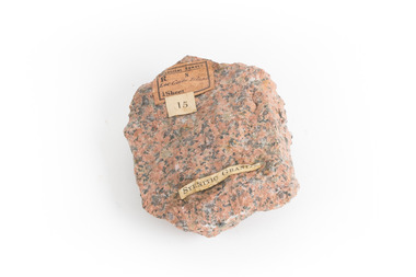
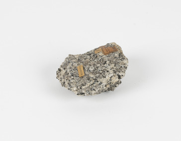
Geological specimen - Granite
Gabo Island sits off the coast of East Gippsland in Victoria, with cliffs of granite in a relatively unique red/pink colour. Early attempts to build a lighthouse on the island were abandoned due to poor foundations, but when a ship ran aground on the nearby Tullaberga Island in 1853 and led to the death of 37 people, efforts were reignited. Construction of a new lighthouse was completed by 1858, using Gabo Island granite. The lighthouse is Australia's second tallest in Australia and continues to play an important role in guiding boats around the coast as they journey between Melbourne and Sydney. The distinct pink colour from the granite means the lighthouse continues to be a defining feature of the island. Gabo Island granite was also used to construct the Treasury Building at 117 Macquarie Street in Sydney, now the Intercontinental Hotel.Granite in the pink colour of this specimen is relatively rare. The connection to the lighthouse on Gabo Island also gives the specimen historic significance and social significance regarding the maritime history of Victoria. This specimen is part of a larger collection of geological and mineral specimens collected from around Australia (and some parts of the world) and donated to the Burke Museum between 1868-1880. A large percentage of these specimens were collected in Victoria as part of the Geological Survey of Victoria that begun in 1852 (in response to the Gold Rush) to study and map the geology of Victoria. Collecting geological specimens was an important part of mapping and understanding the scientific makeup of the earth. Many of these specimens were sent to research and collecting organisations across Australia, including the Burke Museum, to educate and encourage further study.A solid palm-sized mineral, coloured by flecks of pink, red, and grey. Granite is formed by the slow crystallisation of magma below the earth's surface. It is typically composed of a mix of quartz, feldspar, and other minerals, though syenitic granite like this sample has a smaller amount of quartz than typical granite. This different mineral composition leads to the more distinct pink and red colouring.First sticker: [torn]logical survey / R........ S........ / Loc Gabo Island / 1/4 Sheet / Second Sticker: 15 Third Sticker: Syenitic Graniteburke museum, beechworth, indigo shire, beechworth museum, geological, geological specimen, mineralogy, gabo island, gabo island lighthouse, lighthouse, granite, coast, coastal, granite specimen, victoria, coastal cliffs -
 The Beechworth Burke Museum
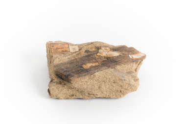
Geological specimen - Yellow Sandstone
This specimen is from Barefoot Hills, Victoria. Sandstones are economically important as major reservoirs for both petroleum and water, as building materials, and as valuable sources of metallic ores. Most significantly, they are the single most useful sedimentary rock type for deciphering Earth history. This specimen is part of a larger collection of geological and mineral specimens collected from around Australia (and some parts of the world) and donated to the Burke Museum between 1868-1880. A large percentage of these specimens were collected in Victoria as part of the Geological Survey of Victoria that begun in 1852 (in response to the Gold Rush) to study and map the geology of Victoria. Collecting geological specimens was an important part of mapping and understanding the scientific makeup of the earth. Many of these specimens were sent to research and collecting organisations across Australia, including the Burke Museum, to educate and encourage further study.A sedimentary rock composed mostly of quartz sand. Sandstone is the second most common sedimentary rock after shale. Sandstones consist of sand-sized grains principally quartz, feldspar and rock fragments. The two major classes of sandstone are arenite and wacke. the colour of sandstone varies from grey, yellow, red and white reflecting the variation in mineral content and cement and is gritty to touch (like sandpaper).Geological survey / R.... S 61 / Loc Bareboot Hills / Sheet / 24SE / 94 /burke museum, beechworth, indigo shire, beechworth museum, geological, geological specimen, mineralogy, sandstone, yellow sandstone, victoria, barefoot hills -
 The Beechworth Burke Museum
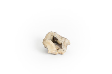
Geological specimen - Chalcedony
This specimen was recovered from Philip Island in Victoria. Chalcedony is composed of Quartz and Silicon Dioxide represented as SIO2. It has and is still used as a gemstone for thousands of years. This is an excellent specimen Chalcedony that shows its aesthetic properties. This specimen is part of a larger collection of geological and mineral specimens collected from around Australia (and some parts of the world) and donated to the Burke Museum between 1868-1880. A large percentage of these specimens were collected in Victoria as part of the Geological Survey of Victoria that begun in 1852 (in response to the Gold Rush) to study and map the geology of Victoria. Collecting geological specimens was an important part of mapping and understanding the scientific makeup of the earth. Many of these specimens were sent to research and collecting organisations across Australia, including the Burke Museum, to educate and encourage further study. Uniquely shaped piece of Chalcedony with opening in the centerburke museum, beechworth, geological, geological specimen -
 The Beechworth Burke Museum
Geological specimen - Granodiorite, Unknown
This specimen was found in Harcourt, Victoria. Harcourt is a small historic gold rush town located in a valley at the foot of Mount Alexander (741 m) in the Central Highlands of Victoria. In recent times the goldrush origins of the town have been replaced by a district known for apples, cider and wine. The Traditional owners of Harcourt are The Dja Dja Wurrung people. Granodiorite is a coarse-grained intrusive igneous rock similar to granite, but containing more plagioclase feldspar than orthoclase feldspar. Granodiorite has greater than 20% quartz by volume, and between 65% and 90% of the feldspar is plagioclase. This piece is of significance due to its provenance in Harcourt, Vic. Granodiorite is commonly produced in volcanic arcs, and in mountain buildings where it emplaces as large batholiths in mountain roots. Granodiorite is the plutonic equivalent of dacite. This specimen is part of a larger collection of geological and mineral specimens collected from around Australia (and some parts of the world) and donated to the Burke Museum between 1868-1880. A large percentage of these specimens were collected in Victoria as part of the Geological Survey of Victoria that begun in 1852 (in response to the Gold Rush) to study and map the geology of Victoria. Collecting geological specimens was an important part of mapping and understanding the scientific makeup of the earth. Many of these specimens were sent to research and collecting organisations across Australia, including the Burke Museum, to educate and encourage further study.Granodiorite is a coarse-grained intrusive igneous rock similar to granite, but containing more plagioclase feldspar than orthoclase feldspar. According to the QAPF diagram, granodiorite has a greater than 20% quartz by volume, and between 65% and 90% of the feldspar is plagioclase.GRANDIORITE. / Locality: / Harcourt, Victoria / Other label: Geological survey / R S / Loc Harcourt quarries [?] Alexander / 1/4 Sheet. | 4 | Granite /granodiorite, granite, burke museum, harcourt, coarse-grained, igneous, plagioclase feldspar, orthoclase feldspar, quartz, mount alexander, the dja dja wurrung people, the traditional owners, central highlands of victoria, gold rush -
 The Beechworth Burke Museum
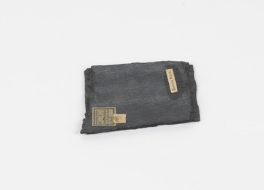
Geological specimen - Slate (Metamorphic), Unknown
This particular specimen was found in the Moorabool Slate quarries in Victoria. The Moorabool Slate quarries was established in the 1860’s by a company of Welshmen with a crew of six who purchased land by the riverside to mine for slate. Under the promise of adding to existing recourses the crew mined the slate which was used for paving and roofing. Slate is a fine-grained, low-grade metamorphic rock that is formed by the transformation of mudstone, shale or sometimes volcanic ash under low pressure and temperatures. It dark colour is due to carbonaceous material or to finely divided iron sulphide. It is believed that Evan Rowlands and Theophilus Williams of Ballarat were the first to discover the slate veins. Slate is a one of the most common natural stones in general use. Being used as paving, flooring, roofing and more. However, its history of being mined in Australia is not common as it is considered that the best places to mine slate is Spain and parts of the United Kingdom. This specimen is part of a larger collection of geological and mineral specimens collected from around Australia (and some parts of the world) and donated to the Burke Museum between 1868-1880. A large percentage of these specimens were collected in Victoria as part of the Geological Survey of Victoria that begun in 1852 (in response to the Gold Rush) to study and map the geology of Victoria. Collecting geological specimens was an important part of mapping and understanding the scientific makeup of the earth. Many of these specimens were sent to research and collecting organisations across Australia, including the Burke Museum, to educate and encourage further study.A somewhat rectangular foliated metamorphic rock composed of quartz, sericite and minerals from the chlorite group that make up the compounds of slate. The rock is dark grey almost black.Geological survey / R S / Loc Moorabool /Slate quarries / 1/4 sheet | 78 | Roofing Slate /burke museum, beechworth, geological, slate, metamorphic, slate (metamorphic), geological specimen, slate specimen, indigo shire -
 The Beechworth Burke Museum
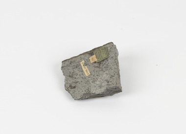
Geological specimen - Spotted Slate, Unknown
This specimen was recovered from Sedgwick, VIC. Spotted slate is a fine-grained porphyroblastic metamorphic rock with a number of compounds including muscovite, quartz, graphite with cordierite poikiloblasts and more. The cordierite poikiloblasts are rounded crystals that size up to 2.5 mm. the growth of these crystals is in response to metamorphism of low to medium intensity. The town Sedgwick was named after British geologist Adam Sedgwick This specimen is part of a larger collection of geological and mineral specimens collected from around Australia (and some parts of the world) and donated to the Burke Museum between 1868-1880. A large percentage of these specimens were collected in Victoria as part of the Geological Survey of Victoria that begun in 1852 (in response to the Gold Rush) to study and map the geology of Victoria. Collecting geological specimens was an important part of mapping and understanding the scientific makeup of the earth. Many of these specimens were sent to research and collecting organisations across Australia, including the Burke Museum, to educate and encourage further study.A solid rectangular hand-sized spotted slate specimen in a shade of light grey with darker flecks throughout Spotted Slate / Locality: Sedgwick Victoria | This is an early specimen / from the Quarter sheet / map. See sample 62 / page 18. Described as 'Spotted Slate' but these / days we would call it spotted hornfels / C. William 15/4/21 slate, spotted slate, victoria, beechworth, burke museum, geological specimen, mineralogy, sedgwick, sedgwick victoria, spotted slate specimen -
 The Beechworth Burke Museum
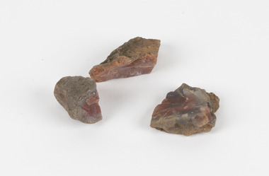
Geological specimen - Unknown, possible Carnelian Agate or Chalcedony
Although it is not known where these specimens were collected, Victoria and other regions of Australia were surveyed for sites of potential mineral wealth throughout the 19th Century. The identification of sites containing valuable commodities such as gold, iron ore and gemstones in a locality had the potential to shape the development and history of communities and industries in the area. The discovery of gold in Victoria, for instance, had a significant influence on the development of the area now known as 'the goldfields', including Beechworth; the city of Melbourne and Victoria as a whole. Agate occurs when amygdales (gas pockets) form in the upper levels of basaltic lava flows. If these pockets or bubbles are iniltrated by water bearing silica in solution, the fluid dries and hardens in layers, forming round or egg shaped nodules or geodes within the rocky matrix. Agate is formed of a silica mineral chalcedony similar to quartz. The term carnelian primarily refers to the reddish shading of the stone; whether the stone is termed an agate or chalcedony type is often influenced by the degree of colour banding the specimen shows. The specimens are significant as examples of surveying activity undertaken to assess and direct the development of the mineral resource industries in Victoria and Australia, as well as the movement to expand human knowledge of earth sciences such as mineralogy and geology in the nineteenth century.Three small geological specimens that appear visually consistent with images of rough or unpolished Carnelian Agate or Chalcedony. geological specimen, geology, geology collection, burke museum, beechworth, indigo shire, north-east victoria, gemstones, agate, carnelian -
 The Beechworth Burke Museum
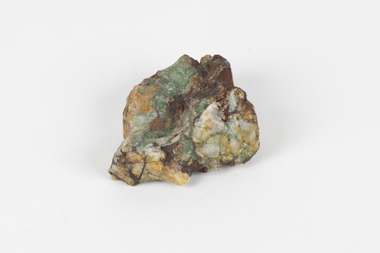
Geological specimen - Malachite in Conglomerate, Unknown
Malachite is a green copper carbonate hydroxide mineral and was one of the first ores used to make copper metal. Malachite has been utilised as a gemstone and sculptural material in the past as its distinctive green color does not fade when exposed to light or after long periods of time. Malachite is formed at shallow depths in the ground, in the oxidizing zone above copper deposits. The material has also been used as a pigment for painting throughout history. Malachite is considered a rare gemstone in that the original deposits for the stones have been depleted leaving behind very few sources. In addition, the use of Malachite as gemstones and sculptural materials remains just as popular today as they were throughout history. It is quite common to cut the stone into beads for jewellery. The fact that Malachite has such a rich colour and one that does not fade with time or when exposed to light makes it particularly rare. Although there is no indication available of the locality from which the specimen was sourced, it is likely that the specimen was collected either in South Australia in the vicinity of the Burra Burra mines or in Victoria as part of programs of geological surveying undertaken in the Nineteenth and Twentieth centuries. This specimen is part of a larger collection of geological and mineral specimens collected from around Australia (and some parts of the world) and donated to the Burke Museum between 1868-1880. A large percentage of these specimens were collected in Victoria as part of the Geological Survey of Victoria that begun in 1852 (in response to the Gold Rush) to study and map the geology of Victoria. Collecting geological specimens was an important part of mapping and understanding the scientific makeup of the earth. Many of these specimens were sent to research and collecting organisations across Australia, including the Burke Museum, to educate and encourage further study.A solid hand-sized copper carbonate hydroxide mineral with quartz pebbles in red conglomorate matrix presenting shades of cream, brown and green.Existing label: Malachite / (green) in / conglomerate / (white quartz / pebbles / in red matrix /geological specimen, geology, geology collection, burke museum, beechworth, geological, indigo shire, malachite, malachite specimen, australian mines, mines, geological survey, conglomorate, matrix -
 The Beechworth Burke Museum
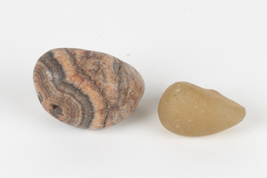
Geological specimen - Agate and Quartz pebbles
... of quartz can vary. These specimens were collected in Victoria ...Agate occurs when amygdales (gas pockets) form in the upper levels of basaltic lava flows. If these pockets or bubbles are iniltrated by water bearing silica in solution, the fluid dries and hardens in layers, forming round or egg shaped nodules or geodes within the rocky matrix. Agate is formed of a silica mineral chalcedony similar to quartz. Although relatively common and semi-precious, agate has been prized since at least 1450 BC - an intricately carved agate seal was found in the 2015 excavation of a grave belonging to a Mycenaeum priest or warrior near Pylos in Greece. Agate is also used in jewellery and other decorative or ritual purposes due to its often striking appearance. Quartz is found all over Australia, including Beechworth in Victoria. It is formed in deep-seated igneous rocks and crystallized through hot aqueous solutions. It can have two forms; Microcrystalline quartz or Crystalline quartz. Microcrystalline quartz is a fine grain quartz where crystalline quartz is often a large crystal. The colour of quartz can vary. These specimens were collected in Victoria in the vicinity of the Burke Museum. Victoria and other regions of Australia were surveyed for sites of potential mineral wealth throughout the 19th Century. The identification of sites containing valuable commodities such as gold, iron ore and gemstones in a locality had the potential to shape the development and history of communities and industries in the area. The discovery of gold in Victoria, for instance, had a significant influence on the development of the area now known as 'the goldfields', including Beechworth; the city of Melbourne and Victoria as a whole.The specimens are significant as examples of surveying activity undertaken to assess and direct the development of the mineral resource industries in Victoria and Australia, as well as the movement to expand human knowledge of earth sciences such as mineralogy and geology in the nineteenth century.Geological specimens of Agate and Quartz respectively; the fist-sized piece of Agate has peach/coral colouring with grey concentric patterning and the smaller piece of quartz is a uniform yellow/orange shade. Existing label: Local pebbles / (agate and / quartz / (yellowish) / egg-shaped). / BB geological specimen, geology, geology collection, burke museum, beechworth, agate, quartz, north-east victoria, indigo shire, geological surveys