Showing 18088 items matching "view-master"
-
 Victorian Railway History Library
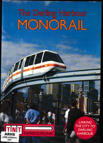
Booklet, View Productions, The Darling Harbour monorail, 1988
An account of the ill fated Darling Harbour monorailIll, map, p.16.non-fictionAn account of the ill fated Darling Harbour monorailmonorails - sydney, transit - sydney -
 Linton and District Historical Society Inc
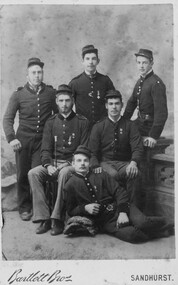
Photograph, Bartlett Bros, View Place, Sandhurst, Linton Fire Brigade Members, circa 1887, 1887
Sepia photograph of a group of six young men in uniform two standing at back, three seated, one seated on floor."Don't know identities of these taken about 1887. Linton Fire Brigade" / "Mrs E Monti 56-58 Rea St, Shepparton 3630".linton fire brigade, fire fighters -
 Greensborough Historical Society
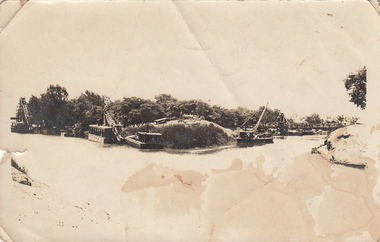
Photograph - Digital image, Charles Marshall et al, View of two small branches of the Nile River, 1917_
Photograph of two small branches of the Nile River, Cairo.Digital copy of black and white photograph"View of two small branches of the Nile Cairo"charles marshall, world war 1, cairo -
 Stawell Historical Society Inc
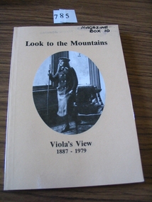
Book, Catherine Good, Look to the Mountains – Viola’s View 1887-1979, 1985
Recollections of a long life 1887-1979 Including childhood at Carrs Plains. Growing up in the Grampians the 90 years of Violet Good (nee Wettenhall) Orange card, Black Print B/W oval photo of a young woman standing next to a leather chair looking out a window Looking to the Mountains Viola's View 1887 - 1979stawell -
 Ringwood and District Historical Society
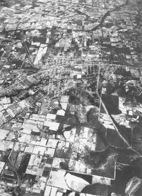
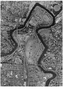
Photograph, Aerial view of Park Orchards and Ringwood - c.1960
Catalogue card reads, "Aerial view of Ringwood". -
 Charlton Golden Grains Museum Inc
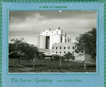
Postcard, A view of Charlton
A view of Charlton. The Season's Greetings from Charlton.charlton, noske bros, noske's, flour mill -
 Stawell Historical Society Inc
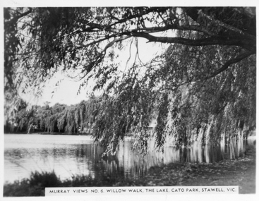
Photograph, Cato Lake -- Willow Walk
Murray Views No. 6. Willow Walk Cato Park. Photograph of willows overhanging Cato Park lake. Two small photos of Murray View appear to be original photos both are the same size. Two small black & white photos of Willow Walk Cato Park Stawell and one enlargement. The photo is by Murray View No 6. The view shows the willows overhanging Cato Lake. Murray Views No 7Murray View No 6. Willow Walk The Lake Cato Park Stawell Vic. Murray Views No 7 stawell -
 Bendigo Historical Society Inc.
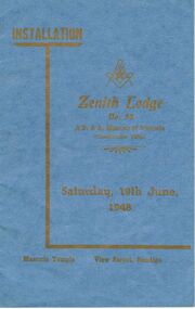
Book - LODGE COLLECTION: ZENITH LODGE NO. 52 PROGRAM, JUNE 1948, Saturday 19th June, 1948
Blue booklet, on front Installation, Zenith Lodge No. 52, A.F. & A. Masons of Victoria. Saturday 19th. June, 1948. (constituted 1866) Masonic Temple, View Street, Bendigo. On front page 'Installation of Brother James King Collis'. Document contains list of past Masters of LodgeCambridge Press. Wor. Bro E.W. Turner, Master, Assisted by Past Masters, will Conduct the Ceremonybendigo, clubs, zenith lodge -
 Federation University Historical Collection
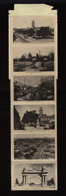
Postcard, Picturesque View of Ballarat
Twelve views of Ballaratballarat, town hall, eureka memorial, ballarat conservatory, sturt street gardens, ballarat panorama, ballarat arch of victory, sturt street ballarat, bridge street, ballarat statuary pavilion, lake wendouree -
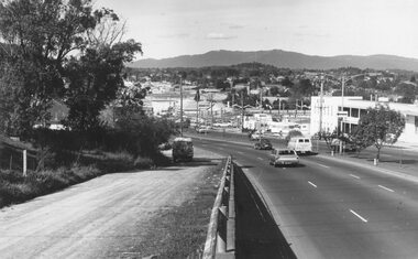
 Ringwood and District Historical Society
Photograph, Maroondah Highway East, Ringwood- 1960. North-easterly view from Ringwood Clocktower, cnr Maroondah Hwy and Warrandyte Road
Black and white photographWritten on back of photograph: "View from clocktower, 1960". -
 Ringwood and District Historical Society
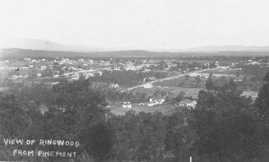
Photograph, View of Ringwood from Pinemont (no date)
Writing on photograph reads, "View of Ringwood from Pinemont". -
 Stawell Historical Society Inc
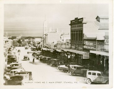
Photograph - Postcard, Murray View No 5 Main Street
Main Street Stawell Murray View No 5 Main Street Stawell Vicstawell streetscape -
 University of Melbourne, Burnley Campus Archives
Photograph - Black and white print, 30c Rose Bed & View of Trees Near River
Labelled,"Rose Bed & View of Trees Near River."rose bed, trees, mrs. jessep, alexander william jessep, principal, a.w. jessep -
 University of Melbourne, Burnley Campus Archives
Photograph - Black and white print, Aerial View of Burnley Campus, 1972
Black and white photograph. Aerial View of Burnley Campus. Enlargement of B92.553C. Aerial view of Burnley Campus.Inscribed on reverse, "30.1.72 2602/62."burnley campus, aerial view, freeway -
![View of a Victorian Sheep Station / [by] Nicholas Caire, circa 1876](/media/collectors/550653872162f11fb04854aa/items/577b58dad0cdd10948cfdc7b/item-media/577b5942d0cdd10948d01fbf/item-fit-380x285.jpg) Kew Historical Society Inc
Kew Historical Society IncPhotograph, View of a Victorian Sheep Station, c.1876
Nicholas Caire was born on Guernsey in the Channel Islands in 1837. He arrived in Adelaide with his parents in about 1860. In 1867, following photographic journeys in Gippsland, he opened a studio in Adelaide. From 1870 to 1876 he lived and worked in Talbot in Central Victoria. In 1876 he purchased T. F. Chuck's studios in the Royal Arcade Melbourne. In 1885, following the introduction of dry plate photography, he began a series of landscape series, which were commercially successful. As a photographer, he travelled extensively through Victoria, photographing places few of his contemporaries had previously seen. He died in 1918. Reference: Jack Cato, 'Caire, Nicholas John (1837–1918)', Australian Dictionary of Biography.An original, rare photograph from the series 'Views of Victoria: General Series' by the photographer, Nicholas Caire (1837-1918). The series of 60 photographs that comprise the series was issued c. 1876 and reinforced a neo-Romantic view of the Australian landscape to which a growing nationalist movement would respond. Nicholas Caire was active as a photographer in Australia from 1858 until his death in 1918. His vision of the Australian bush and pioneer life had a counterpart in the works of Henry Lawson and other nationalist poets, authors and painters.Views of Victoria (General Series) No.29 / ‘View of a Victorian Sheep Station’ / Albumen silver photograph mounted on boardOn Reverse: ‘The present illustration is characteristic of a Squatter’s Station in Victoria, and is situated near Elphinstone. In the centre of the picture may be seen the Squatter’s residence or head-quarters surrounded by sheds and out-houses, and in the foreground is a flock of sheep in charge of a lad. Of late years it has become the practice to erect fences around the Australian Sheep Stations, which necessitates only the services of a boundary rider, and dispenses with those of a number of shepherds.’nicholas caire (1837-1918), landscape photography -
![View of Sailor’s Creek Falls / [by] Nicholas Caire, circa 1876](/media/collectors/550653872162f11fb04854aa/items/577b5d13d0cdd10948d24e07/item-media/577b5d7dd0cdd10948d282ff/item-fit-380x285.jpg) Kew Historical Society Inc
Kew Historical Society IncPhotograph, Anglo-Australasian Photographic Company, View of Sailor’s Creek Falls, c. 1876
Nicholas Caire was born on Guernsey in the Channel Islands in 1837. He arrived in Adelaide with his parents in about 1860. In 1867, following photographic journeys in Gippsland, he opened a studio in Adelaide. From 1870 to 1876 he lived and worked in Talbot in Central Victoria. In 1876 he purchased T. F. Chuck's studios in the Royal Arcade Melbourne. In 1885, following the introduction of dry plate photography, he began a series of landscape series, which were commercially successful. As a photographer, he travelled extensively through Victoria, photographing places few of his contemporaries had previously seen. He died in 1918. Reference: Jack Cato, 'Caire, Nicholas John (1837–1918)', Australian Dictionary of Biography.An original, rare photograph from the series 'Views of Victoria: General Series' by the photographer, Nicholas Caire (1837-1918). The series of 60 photographs that comprise the series was issued c. 1876 and reinforced a neo-Romantic view of the Australian landscape to which a growing nationalist movement would respond. Nicholas Caire was active as a photographer in Australia from 1858 until his death in 1918. His vision of the Australian bush and pioneer life had a counterpart in the works of Henry Lawson and other nationalist poets, authors and painters.Views of Victoria (General Series) No.32 / 'View of Sailor’s Creek Falls’ / Albumen silver photograph mounted on boardOn Reverse: ‘The Sailor’s Creek Falls are situated near Daylesford, in one of the valleys of the Jim Crow Ranges. The Creek at this particular juncture is naturally adapted for the formation of a large reservoir. The stream of water is small during summer months, but a great body of water may sometimes be seen during the winter or wet seasons.’nicholas caire (1837-1918), sailor's creek (vic), jim crow ranges, daylesford, sailor's falls, photography - landscapes - victoria -
 Ringwood and District Historical Society
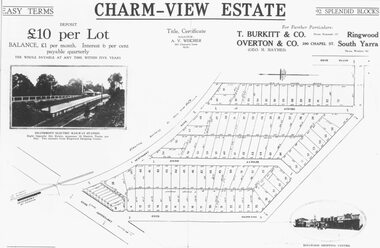
Photograph, Land sale advertisement for Charm View Estate, Heathmont - 1927
Map - Charm-View EstateTyped below photograph, "From 1927 land subdivision brochure". -
Federation University Historical Collection
Image, Aerial View of Ballarat
Lithograph of an aerial view of Ballarat.ballarat, aerial -
 University of Melbourne, Burnley Campus Archives
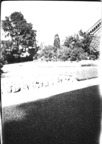
Photograph - Black and white negative, Garden View, 1922-1923
Garden View. Pavilion in background.pavilion, j.l. provan, garden view -
Whitehorse Historical Society Inc.
Article, A Living, working view of our heritage, 1992
Matheson's Orchard, the last working orchard in NunawadingMatheson's Orchard, the last working orchard in Nunawading will soon be open to the public. Council purchased the orchard in 1988. The plan is to run the orchard as it would have operated in the 1930's providing a living and working view of Nunawading's heritage. The eldest child, Marjory, wife of Rev Rhys miller is writing a history of the orchard for Council.Matheson's Orchard, the last working orchard in Nunawading orchards, matheson, charles, city of nunawading -
 Mt Dandenong & District Historical Society Inc.
Photograph, View From George Barber's Home On Olinda Creek Towards The Gap. c1905, 1905
Black and white photograph showing view towards The Gap (Jeeves Saddle), (Five Ways) taken c1905. Detailed inscription on back handwritten by John Lundy-Clarke in 1973.1905 (c ) view from Barber’s home on Olinda Creek, towards the Gap, then known as Jeeves Saddle. Barber’s stable in foreground. “Shiloah” Complex centre right. Tait’s house in gully just left of centre. Logan’s house can just be seen under magnifier at top of same gully near line of Barber’s Road. “Kalorama” just below lowest portion of Gap skyline with Barnes (Paynters) house “Iona” to its left. Photo copied 1973. JLC. george barber, shiloah, kalorama, iona, olinda creek, the gap, jeeves saddle, tait, paynter, barber -
 Ringwood and District Historical Society
Photograph, Maroondah Highway West, Ringwood- 1974. Easterly view from Heatherdale Road
Black and white photograph (2 copies)Written on backing sheet, "View from Ringwood Hill - 1974". -
 Ringwood and District Historical Society
Photograph, View of the Dandenongs from Loughnan Hill (no date)
Catalogue card reads, "View of the Dandenongs from Loughnan Hill". -
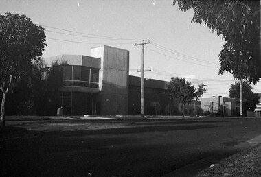 Ringwood and District Historical Society
Photograph, View of Telephone Exchange, Ringwood 1981
B&W PhotoWritten on back of photograph, "2/81. View Telephone Exchange". -
 Ithacan Historical Society
Photograph, View of Exoghi and Afales Bay - Ithaca, c1970s
At an altitude of 340m, the picturesque village of Exogh in northern Ithaca, lies on the Homeric mountain of Neion. The village overlooks Aphales Bay and across the water the neighbouring island of Lefkada. During the Middle Ages and at the beginning of the Venetian rule, it was one of the most populated villages of the island, offering safety from the pirates, and an excellent view of the channel, the sea and the bays around the northern Ithaca.Some of the earliest Ithacan settlers in Melbourne were from the mountain village of Exoghi, including the founding president AJ.J. Lekatsas (Lucas). The village now has very few permanent residents with most having migrated or moved to the cities of Greece. A coloured photograph of a view overlooking the village of Exoghi and Aphales Bay on the island of Ithaca. The photograph was taken from the bell tower of the church of Panagias (the Virgin/Our Lady) sta Pernarakia located at the top of the mountain. The mountains which are visible across the skyline are the neighbouring island of Lefkada. mountain villages, ithaca -
 Mt Dandenong & District Historical Society Inc.
Photograph, 1913 View Over Logan's House in Village Settlement, 1913
Photograph taken in 1913 from Barbers Road showing the view down the valley. Roof in foreground is house on Bob Logan's Lot 28 in the Village Settlement. This photograph has a detailed inscription on the back handwritten by John Lundy-Clarke in 1974.1913 view over Logan’s house on Village Settlement Lot 28 taken from Barber’s Road. This is the house that the runaway log leaped over in 1930 to land far down the orchard row beyond the house. “Shiloah” is centre partly behind the clump of trees and the paddocks of Child and Richardsons pioneer selections are in the background. Link Road is centre right.logan, bob logan, robert logan, barbers road, shiloah, child, richardson, link road -
 Ringwood and District Historical Society
Flyer, Land Sale Advertisement and auction notice - Range View Estate, Ringwood, Victoria - 1920
Advertisement for sale of 150 residential allotments with terms of sale, summary of local features and services, and map showing location and layout of subdivision within the boundary of Mitcham to the west of Ringwood, Victoria. Copy of newspaper advertisement (The Herald, Melbourne, Wednesday 3 March, 1920) refers to public auction date for Range View Estate Ringwood - Saturday, 27th March, 1920.Subdivision includes Deep Creek Road, Range View Grove, Warnes Road, Tarrangower Avenue, Prince Edward Avenue, James Avenue, and White Horse Road, Mitcham. Agents - Phillips & Nicholson, 281 Collins Street, Melbourne, Telephone Central 10907. -
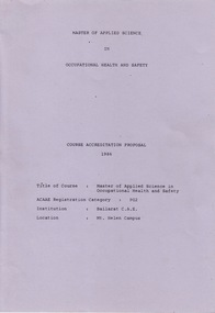 Federation University Historical Collection
Document - Document - Accreditation Proposal, VIOSH: Course Accreditation Proposal, Master of Applied Science in Occupational Health and Safety, 1986
Victorian Institute of Occupational Safety and Health (VIOSH) Australia is the Asia-Pacific centre for teaching and research in occupational health and safety (OHS) and is known as one of Australia's leaders on the field. VIOSH has a global reputation for its innovative approach within the field of OHS management. VIOSH had its first intake of students in 1979. At that time the Institution was known as the Ballarat College of Advanced Education. In 1990 it became known as Ballarat University College, then in 1994 as University of Ballarat. It was 2014 that it became Federation University. VIOSH Australia students are safety managers, senior advisors and experienced OHS professionals. They come from all over Australia and industry. Students are taught active research and enquiry; rather than textbook learning and a one-size fits all approach. VIOSH accepts people into the Graduate Diploma of Occupational Hazard Management who have no undergraduate degree - on the basis of extensive work experience and knowledge. Document is a detailed proposal for Course Accreditation: Master of Applied Science in Occupational Health and Safety, Ballarat College of Advanced Education, Mount Helen Campus.Lecturers involved in the teaching of aspects of the Course include Keith Brown, Jack Harvey, Dennis Else, R Gillies, Tom Norwood, Max Brooke, Ronald Kemp, Brian Lees, P Swan, Margaret Torode, Derek Viner, Eric Wigglesworth. Gerald Fernandez, R Lang, J Lowing, G Bradley, Peter Reid, and Ruan Maud. Dulce Brooke was the Information Librarian and also co-ordinator with Dennis Else in Manual and On-Line Information Retrieval. Some of these people were involved in more than one area. Dennis Else was main co-ordinator for this course. 114 typed A4 pages outlining proposal plus supporting articles. vialet coloured cover. Stapled togetherviosh, victorian institute of occupational safety and health, ballarat college of advanced education, master of applied science in occupational health and safety, accreditation proposal, keith brown, jack harvey, dennis else, r gillies, tom norwood, max brooke, ronald kemp, brian lees, p swan, margaret torode, derek viner, eric wigglesworth, gerald fernandez, r lang, j lowing, g bradley, peter reid, run maud, dulcie brooke -
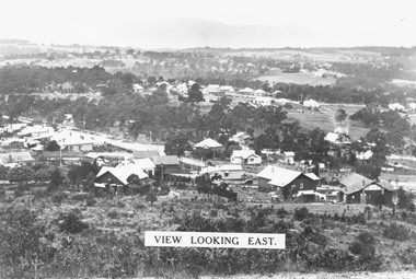 Ringwood and District Historical Society
Photograph, View from Loughnan's Hill looking east c1930
Black and white photograph taken from vacant land on hill. Scene overlooks housing and trees. Mountains in background. (2 copies)Typed on photograph, "View looking east". Typed below photograph, "View from Loughnans Hill c1930. Maroondah Highway, Catholic church all top right corner". -
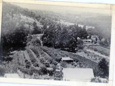
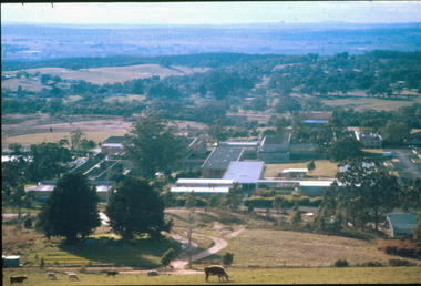 Federation University Historical Collection
Photograph, Aerial View of Mount Helen Campus, 1985
Aerial views of Mount Helen Campusmount helen campus, aerial