Showing 1144 items
matching west side
-
 Ballarat Tramway Museum
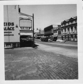
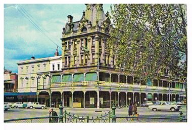
Photograph - Digital image, Chris Phillips, late 1950's?
... in Lydiard St North with the various buildings on the west side... in Lydiard St North with the various buildings on the west side ...Yields information about the tram operations in Lydiard St North during the 1950's and the appearance of the buildings.Digital image, black and white, of a bogie tram north bound in Lydiard St North with the various buildings on the west side of the street - 1950's photo, prior to the installation of the lights on the tramcars. Has Reid's Coffee Palace in the photograph. Taken from the Railway Station entry.trams, tramways, lydiard st north, tram 13 -
 Linton and District Historical Society Inc
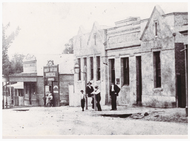
Photograph, Streetscape, Sussex Street, Linton, Railway Hotel, James Nelson Undertaker, Linton Public Library
... no. 338) which shows both east and west sides of Sussex Street... both east and west sides of Sussex Street. The photograph has ...Photograph taken after 1901 as James Nelson took over his family's undertaker's business in that year.This is a cropped version of a photograph (Registration no. 338) which shows both east and west sides of Sussex Street. The photograph has been mounted on card (for use at LDHS exhibition, 1983). This version of the photograph (showing Sussex St east side) is also Mounted photo 444.sussex street linton, railway hotel linton, james nelson undertaker, linton public library -
 Port of Echuca
A coloured rectangular photograph, November 1979
... , and in 2010 the new Echuca Libray was built on the west side... the new Echuca Libray was built on the west side of this building ...This photograph was taken from Hare Street and shows the City of Echuca council offices, before the Shire of Campaspe came about. As the Shire got bigger these offices were extended, and in 2010 the new Echuca Libray was built on the west side of this building.This photograph is significant because it shows the City of Echuca building at the end of the 1970's.A coloured rectangular photograph of the City of Echuca offices, taken in 1979 from Hare Street.Stamped in red on the back 'Print made by Kodak M Nov. 79. It's Kodak for Color.' In blue pen in the top left hand corner is an uppercase R. shire of campaspe, city of echuca, hare street, 1979 -
![Plan, Improvements on the Camp Reserve Ballarat, 1870, 26/4/1870 (exact); Traced by Henry [Mornes?], district surveyor, on the above date](/media/collectors/4f729f6797f83e0308601707/items/4f72a4fa97f83e0308602508/item-media/59b79d3921ea680200c6b8a7/item-fit-380x285.jpg) Federation University Historical Collection
Federation University Historical CollectionPlan, Improvements on the Camp Reserve Ballarat, 1870, 26/4/1870 (exact); Traced by Henry [Mornes?], district surveyor, on the above date
... shown in on the west side of Camp Street is now used... shown in on the west side of Camp Street is now used ...The Ballarat Camp housed the Goldfields administrators. It was from this site that the troopers left on the morning of 3 December 1854 to attack the Eureka Stockade. Much of the area shown in on the west side of Camp Street is now used by the Federation University Arts Academy.Hand-drawn plan on white linen showing the camp reserve in what is now known Ballarat's Camp Street. The plan shows allotments in an area bounded by Mair, Sturt and Lydiard Streets. The plan has colours indicating wooden buildings, stone buildings, brick buildings, Wood & zinc buildings, and wood & brick buildings.ballarat, camp street, horace walker, henry mornes, goldfields architecture, reserve for public, buildings, goldfields administration, eureka stockade -
 Glenelg Shire Council Cultural Collection
Photograph - Photographic print - Weatherboard building, c. 1970
... on road outside weatherboard building. Victoria Hotel, west side.... Victoria Hotel, west side Percy Street, between Tyers and Fern ...Photographic print of a rephotographed photograph. Image shows a weatherboard building with 2 attic windows, next to a single storey stone building. Small Norfolk pine in treeguard on road outside weatherboard building. Victoria Hotel, west side Percy Street, between Tyers and Fern Streets. -
 Bendigo Historical Society Inc.
Postcard - PALL MALL, BENDIGO
... along west side of street. War Memorial on LH side, garden... towards Post Office along west side of street. War Memorial on LH ...Postcard, color. View looking north towards Post Office along west side of street. War Memorial on LH side, garden in front, iron fencing along footpath. On back of card: Bendigo, Victoria, Looking to the Post Office, Pall Mall, from Charing Cross.'Nu Color Vuebendigo, streetscape, pall mall, bendigo, post office, war memorial, pall mall -
 Whitehorse Historical Society Inc.
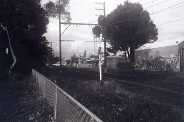
Photograph, Railway Station from Car Park, 1/06/2009
... . This photograph is of the station taken from the car park on west side.... This photograph is of the station taken from the car park on west side ...One of a collection of photographs taken of the Nunawading Railway Station prior to the lowering of the railway line and building of the new railway station on the western side of Springvale Road so that the Springvale Road Rail Crossing can be eliminated.Black & white photograph of the precinct surrounding the Nunawading Station and the Springvale Road Railway crossing. This photograph is of the station taken from the car park on west side of Springvale Road, north of railway line behind Recreation Centre. See NP 3545 to NP3567 for the complete set of photographsnunawading railway station, springvale road nunawading, redevelopment of railway line/springvale road, nunawading recreation centre -
 Ballarat Tramway Museum
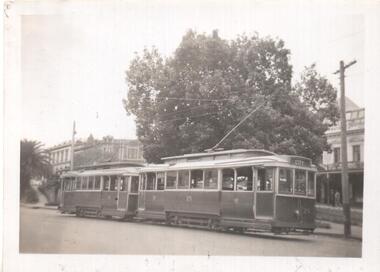
Photograph - Black & White Photograph/s, Lee A Ratten, late 1940's to early to mid 1950's
... of City. In the background are the building on the west side... the destination of City. In the background are the building on the west ...Yields information about tram operations in Ballarat using City Loop.Black and white photograph of Ballarat 25 and another single trucker at the City Loop. Tram 25 has the destination of City. In the background are the building on the west side of Sturt St and an advertisement for Penfolds Wines. Photo possibly Lee A Ratten - see related document and Reg Item 7185.trams, tramways, ballarat, sturt st, city loop, tram 25 -
 Kew Historical Society Inc
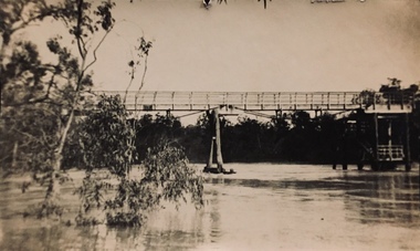
Photograph - Zig-zag Bridge, Kew, Henry Beater Christian, 1920s
... to transport stone from the west side of the Yarra to the east side... was built in the 1870s to transport stone from the west side ...An item from an outstanding and diverse photographic collection, assembled by members of the Christian family of Pakington Street, Kew, comprising professional and amateur photography, depicting individuals, natural and settled environments and the interactions between these worlds. Many of the photographs vividly capture the worlds of three generations of men - Henry Christian, his son Orlando Henry Beater Christian, and his grandson of Henry Beater Christian. The most important photographer was the youngest, Henry Christian, who was a keen explorer, not just of his immediate environment but also of the Victorian wilderness. His major opus is contained in two albums in which he records, sometimes in majestic detail and on other occasions the intimate features of the natural world. His photographic travels during the 1920s, often in solitary ramblings but on other occasions with companions, recall the heroic landscape photography of an earlier era, pioneered by Nicholas Caire. In addition to their aesthetic value, the albums are historically significant records within the State of Victoria, of what is now a distant point in time, and of places that have become radically altered through human intervention.Sepia photograph of the wooden trestle Zig-Zag Bridge across the River Yarra. The bridge was built in the 1870s to transport stone from the west side of the Yarra to the east side. The stone was used in the construction of the Kew Asylum. The bridge continued to link the two asylums on each side of the river. yarra river -- kew (vic), zig-zag bridge -- kew (vic.), henry beater christian, christian-washfold collection -
 Melton City Libraries
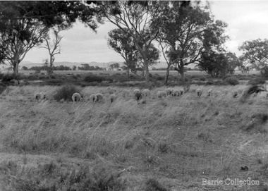
Photograph, Ferris Road Landscape, Unknown
... Barrie House on Ferris Road was located on the west side... Barrie House on Ferris Road was located on the west side south ...Barrie House on Ferris Road was located on the west side south of Highway. Weather board house was moved from Harkness Rd in 1941 and was moved to Bulmans Road near Porteous Road 1988/90 The site was near the entrance to the Harness Racing Complex.Black and white photos of the Ferris Road landscapeagriculture -
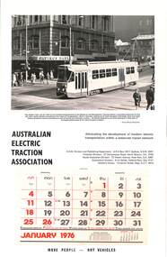 Melbourne Tram Museum
Document - Calendar, AETA 1976 featuring a new Z class tram
... it was fully demolished - buildings on the west side have already been... demolished - buildings on the west side have already been demolished ...The AETA published calendars on an annual basis through to 2005, promoting electric transport in Public Transport. In the background is the old State Savings Bank buildiing before it was fully demolished - buildings on the west side have already been demolished. Photo by Shane McCarthy.Yields information about the AETA promotional activities.Australian Electric Traction Association (AETA) Calendar for 1976, featuring a photograph of a then new Z class in Bourke St Melbourne at the intersection with Elizabeth St. Gives contact details for the AETA divisions. Stapled to the sheet is a 12 sheet preprinted calendar for 1976 with various details of holidays etc. Printed on card with a punched hole on the top edge.calendars, aeta, bourke st, z class, state savings bank -
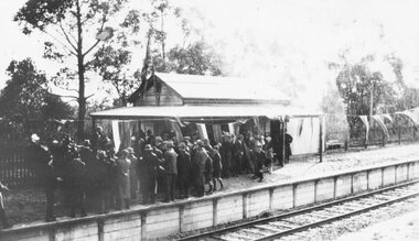 Ringwood and District Historical Society
Photograph, Opening Heathmont Railway Station in May 1926, 1926
... to the railway platform. The Station building was located on the west... building was located on the west side of the tracks, near ...Opening Heathmont Railway Station in May 1926. The photo shows the audience, including Bill Everard MLA, at the entrance to the railway platform. The Station building was located on the west side of the tracks, near the corner of Heathmont and Canterbury Roads. At the officially opening, the ribbon was cut by Louise Pump, wife of Herman. -
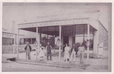 Clunes Museum
photograph, JOHN PHILLIPS, SADDLER
... ON WEST SIDE OF BUILDING IN FRASER STREET. .1 PHOTOGRAPH... AND CUSTOMERS STANDING IN FRONT OF SHOP. SMALL PICKET GATE ON WEST SIDE ...PHOTOGRAPH OF BLUESTONE BUILDING, WITH PICKET GATE. BUSINESS OWNED BY JOHN PHILLIP.PHOTOGRAPH OF JOHN PHILLIP SADDLER & HARNESS MAKER SHOP, FRASER STREET. THREE HORSE COLLARS DISPLAYED ON VERANDAH POSTS.. WORKMEN AND CUSTOMERS STANDING IN FRONT OF SHOP. SMALL PICKET GATE ON WEST SIDE OF BUILDING IN FRASER STREET. .1 PHOTOGRAPH OF BUILDING AND WORKERS .2 COPY OF PHOTOGRAPHlocal history, photography, photographs, shops, john phillip saddler & harnes maker shop., buildings. -
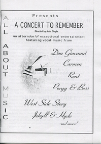 Ballarat Heritage Services
Program, A Concert to Remember
... vocal music from Don Giovanni, Carmen, Rent, Porgy & Bess, West..., Porgy & Bess, West Side Story, Jekyll & Hyde and more! A program ...A program on A4 white paper with black text of 8 pages with a sketch of a grand piano on coverALL ABOUT MUSIC Presents A CONCERT TO REMEMBER Directed by John Dingle An afternoon of exceptional entertainment featuring vocal music from Don Giovanni, Carmen, Rent, Porgy & Bess, West Side Story, Jekyll & Hyde and more!concert, musical, jacqueline dark, andrew dark, singers, singing, music, opera -
Glenelg Shire Council Cultural Collection
Photograph - Photograph - Main Breakwater construction, Portland, Feb-54
... Black & white photo taken from Battery Point. West Side... Battery Point Black & white photo taken from Battery Point. West ...Port of Portland Authority ArchivesBack: Purple PHT Stamp Print No. 227 Date taken 3-2-54 Subject Main Breakwater from Battery Pointport of portland archives, main breakwater, construction, battery point, harbour development -
Glenelg Shire Council Cultural Collection
Photograph - Photograph - Main Breakwater construction, Portland, Mar-54
... Black & white photo taken from Battery point. West Side... point. West Side Main Breakwater under construction. One man ...Port of Portland Authority ArchivesBack: Purple PHT Stamp - Print No - 4/34 Neg. No. 231 Date taken 2.3.54 Subject Main Breakwater from Battery Pointport of portland archives, battery point, main breakwater, construction, harbour, portland -
 Bendigo Historical Society Inc.
Postcard - SHAMROCK HOTEL, BENDIGO
... west side of Pall Mall. Iron fence in foreground, cars..., looking from west side of Pall Mall. Iron fence in foreground ...Postcard, color. Image shows Shamrock Hotel, looking from west side of Pall Mall. Iron fence in foreground, cars in street. On back of card: ' Shamrock Hotel, Bendigo, Victoria. The present Shamrock Hotel was built in 1897, and has become one of the city's best loved land marks'Nu Color Vuebendigo, buildings, shamrock hotel, bendigo, shamrock hotel, pall mall -
Port Melbourne Historical & Preservation Society
Photograph - Port Melbourne, Pat Grainger, 1996
... of the 1910 post office .04 View north of Bay Street footpath, west... Street footpath, west side Photograph Port Melbourne Pat Grainger ...Four panoramic black&white photos taken c1996 .01 View toward city of Nott Street and the school .02 View toward city of Nott Street, vertical .03 Pedestrian crossing in front of the 1910 post office .04 View north of Bay Street footpath, west sidebuilt environment, nott street, bay street -
 Bendigo Historical Society Inc.
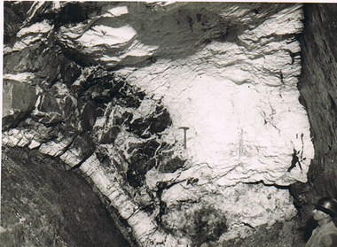
Photograph - MCCOLL, RANKIN AND STANISTREET COLLECTION: MONUMENT HILL MINE
... of south face showing western side of upper roof. On west side... side of upper roof. On west side is main w fault. On the face ...Photograph. Black and white photo - "Monument Hill Mine 655'. Int stope below 640' level 150' south of shaft. Picture of south face showing western side of upper roof. On west side is main w fault. On the face is a rock hammer. Details at ? qtz and intrusions above it.photograph, landscape, monument hill mine 655 -
 Whitehorse Historical Society Inc.
Photograph, Car Park - rear of Recreation Centre, 1/06/2009
... . This photograph is of the car park on north side of railway line and west... on north side of railway line and west side of Springvale Road ...One of a collection of photographs taken of the Nunawading Railway Station prior to the lowering of the railway line and building of the new railway station on the western side of Springvale Road so that the Springvale Road Rail Crossing can be eliminated.Black & white photograph of he precinct surrounding the Nunawading Station and the Springvale Road Railway crossing. This photograph is of the car park on north side of railway line and west side of Springvale Road behind the Recreation Centre. This will be site of new station. See NP 3545 to NP3567 for the complete set of photographsnunawading railway station, springvale road nunawading, redevelopment of railway line/springvale road. -
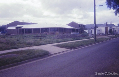
 Sunbury Family History and Heritage Society Inc.
Photograph, 17 December 1985
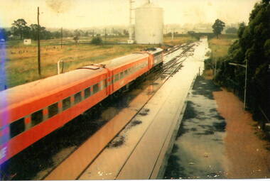
... and the open ground with the storage silo on the west side... silo on the west side of the railway line. sunbury railway ...On 17th December 1985 record torrential rain fell in Sunbury, which flooded the main Melbourne Bendigo rail line and disrupted traffic. The photograph is looking to the north of the station and takes in the historic Macedon Street bridge and the open ground with the storage silo on the west side of the railway line. A coloured photograph of a former V Line train stopped at a station where the railway line has been flooded. A storage silo occupies vac ant ground adjacent to the railway line.sunbury railway station, storage silos, horne street -
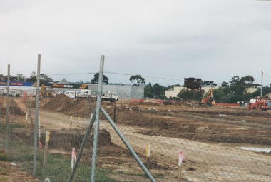 Sunbury Family History and Heritage Society Inc.
Photograph, 13 April 2000
... of railway land on the west side of Sunbury station... on the west side of Sunbury station for the construction of commercial ...In 2000 work commenced on the further development of railway land on the west side of Sunbury station for the construction of commercial and entertainment facilities. Prior to this time the land had been undeveloped and was often used to accommodate visiting circus troupes. Cereal storage silos also occupied this area for some time. The development of this area has been a reflection of the rapid expansion of settlement within Sunbury and surrounding areas that occurred during the early years of the twentieth century.A coloured photograph of a fenced off area undergoing development with earthmoving equipment and trucks in operation and some commercial buildings visible in the middle distance.sunbury railway station -
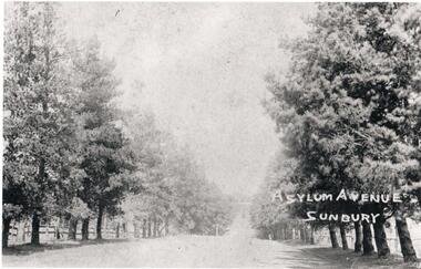 Hume City Civic Collection
Photograph, Asylum Avenue Sunbury
... . In the late 1990s the trees along the west side of The Avenue were.... In the late 1990s the trees along the west side of The Avenue were ...This is a photograph of The Avenue leading to the Sunbury Asylum. it is lined with pine trees and post and rail fences. At some stage oak trees were also planted along the avenue. In the late 1990s the trees along the west side of The Avenue were removed as a result of housing development. They were later replaced.The Avenue was the main entrance leading to the former Sunbury AsylumA non-digital copy of a black and white photograph of a tree lined avenue with a white border. Unmounted.Written on the photo: Asylum Avenue/ Sunburysunbury asylum, trees, fences, the avenue, george evans collection -
 Melton City Libraries
Photograph, High Street Elizabeth Dowling Daley property, Unknown
... death. Max Myers built a house on the west side of the cottage. ... death. Max Myers built a house on the west side of the cottage ...Elizabeth Daley later turned her father's bootmaker shop into a haberdashery shop. She died in 1949. Her sister Annie had a tiny house nearby according to Edna. John Lugg rented the house after her death. Max Myers built a house on the west side of the cottage. Elizabeth Daley's property with Max Myers' house in the backgroundlocal identities -
 Ringwood and District Historical Society
Photograph, Opening Heathmont Railway Station in May 1926, 1926
... building was located on the west side of the tracks, near... platform. The Station building was located on the west side ...Opening Heathmont Railway Station in May 1926. The photo shows the audience, including Bill Everard MLA, just behind the gate at the entrance to the railway platform. The Station building was located on the west side of the tracks, near the corner of Heathmont and Canterbury Roads. At the officially opening, the ribbon was cut by Louise Pump, wife of Herman. -
 Bendigo Historical Society Inc.
Document - LONG GULLY HISTORY GROUP COLLECTION: PART OF SANDHURST ROLL
... street by street and also listed East or West side or North... or West side or North or South side. Document LONG GULLY HISTORY ...Copies of part of the Sandhurst Roll approx 1850's. Copies of pages 23, 24, 31, 32, 33, 34, 37, 38, 51, 52, 53 and 54. Pages contain the name of the resident and occupation. Names are listed street by street and also listed East or West side or North or South side.bendigo, history, long gully history group, the long gully history group - part of sandhurst roll -
 Ringwood and District Historical Society
Photograph, Opening Heathmont Railway Station in May 1926, 1926
... building was located on the west side of the tracks, near... building was located on the west side of the tracks, near ...Opening Heathmont Railway Station in May 1926. The photo shows Herman Pump (centre) and Bill Everard MLA (left), at the gate at the entrance to the railway platform. The Station building was located on the west side of the tracks, near the corner of Heathmont and Canterbury Roads. At the officially opening, the ribbon was cut by Louise Pump, wife of Herman. -
 Linton and District Historical Society Inc
Photograph, Murrell's Newsagency, Sussex Street, Linton, circa 1940
... William Murrell ran a newspaper shop on the west side...William Murrell ran a newspaper shop on the west side ...William Murrell ran a newspaper shop on the west side of Sussex Street until 1932, when he moved his business to a site formerly occupied by Dan Cornish (who ran it as a shoe shop). After William Murrell died the newsagency was run for many years by his daughter Carrie Murrell.Black and white photograph which shows buildings along the east side of Sussex Street, including Murrell's newsagency, the fire brigade building, and another shop or dwelling.murrell's newsagency, linton fire brigade building, buildings, shops, sussex street linton -
Glenelg Shire Council Cultural Collection
Photograph - Photograph - Percy Street, Portland, 1970s
... shows west side of Percy Street between Henty and Tyers Streets... print of a rephotographed photograph. Image shows west side ...Photographic print of a rephotographed photograph. Image shows west side of Percy Street between Henty and Tyers Streets. Four single story buildings (one behind wooden fence) facing street. Robertson Store - 2 storey, round roof, far right of photo. Several people and horses and carts in street (unmade).Front: 'Robertson Store' - green inkportland street scene, percy street -
 Tatura Irrigation & Wartime Camps Museum
Photograph, Williams House, Hogan St, 2001
... Williams house Hogan St North side, West of Pres. Church... Williams house Hogan St North side, West of Pres. Church Williams ...Williams house Hogan St North side, West of Pres. Churchwilliams house, hogan st, photograph, people