Showing 11008 items matching " land"
-
 Whitehorse Historical Society Inc.
Document - Land Auction and History, Trove Park Drive, Vermont, 1969
Subdivisional land auction documents for Trove Park Drive off Terrara Road, Vermont and history of the site, including maps and photographs.Subdivisional land auction documents for Trove Park Drive of Terrara Road, Vermont and history of the site, including maps and photographs.non-fictionSubdivisional land auction documents for Trove Park Drive off Terrara Road, Vermont and history of the site, including maps and photographs.trove park drive estate vermont, trove park drive vermont, terrara road vermont, uplands vermont, chris round, murray round -
 Sunbury Family History and Heritage Society Inc.
Photograph
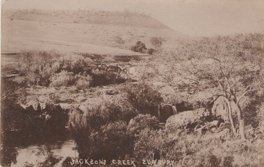
he photograph was taken of Jacksons Creek near the waterfalls and weir which are downstream from Macedon Street.A sepia photograph in postcard format of a creek with the water tumbling over rocks. The land in the distance rises above the surrounding valley.JACKSONS CREEK SUNBURYjacksons creek, sunbury -
 Queen's College
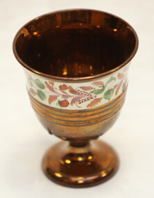
Lustreware chalice, c.1850
Lustreware chalice supposedly used in a communion service when John Wesley preached his first sermon at Land's End -
 Camberwell Historical Society
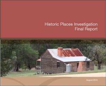
Booklet (Item) - Report, Phil Honeywood, Historic Places Investigation Final Report, 2016
melbourne, victoria, council -
 Bendigo Historical Society Inc.
Document - LAND SALES REGISTER 27.7.1860 TO 12.9.1882 - SANDHURST SALES
Large register, brown cover. On spine Special Land Sales Book, Sandhurst Sales. No. 5 printed on top of spine.sandhurst, bendigo, land sales -
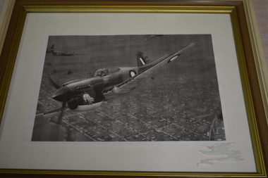 Wangaratta RSL Sub Branch
Framed photocopy of photograph, Unknown
Kitty Hawk planeCream brown and gold coloured frame containing a photocopy image of plane with two planes in background flying over land.kitty hawk, ww2 -
Lakes Entrance Historical Society
Book, Department of Conservation and Environment, Lake Tyers Foreshore Reserves Management Plan, 1991
An approved management plan relating to the public foreshore land between Lake Bunga and Mill Point. Contains plans and appendices.waterfront, vegetation -
Clunes Museum
Document - BUSINESS CARD
BUSINESS CARD FOR D MATHIAS HOUSE & LAND AGENT. INSPECTOR OF WEIGHTS & MEASURES. CHURCH ST. THOMAS TOWN MERTHYRd mathias, business card, house & land agent -
Lakes Entrance Historical Society
Book, Hibbins, Fahen and Askew, Local History Handbook, 1985
A guide to sources with information on people, land and buildings in Victoria, written for the amateur local history and family history researcher. Indexedhistory -
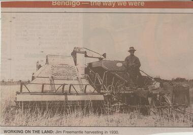 Bendigo Historical Society Inc.
Newspaper - JENNY FOLEY COLLECTION: WORKING ON THE LAND
BHS CollectionBendigo Advertiser ''The way we were'' from 2002. Working on the land: Jim Freemantle harvesting in 1930. The clip is in a folder.newspaper, bendigo advertiser, the way we were -
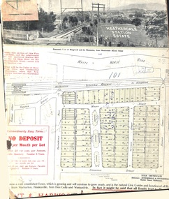 Ringwood and District Historical Society
Card - Land Subdivision Clipping, Heatherdale Station Estate, Ringwood, Vic. - circa 1923
Cardboard-backed partial front page copy of a land sale advertisement map with penciled sales notations for some blocks.Subdivision includes Heatherdale Road, Molan Street, Yallourn Parade, Newman Street, and Madden Street. Location map inset shows Purches Street and Forster Street, Mitcham, and approved site for Heatherdale railway station. -
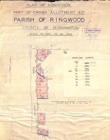 Ringwood and District Historical Society
Map - Plan of Subdivision, Part of Crown Allotment 40C, Parish of Ringwood, County of Mornington - (Undated, circa 1940s)
Copy of land title map in manilla folder showing layout and size of residential allotments in Allens Road Heathmont, Victoria.J.S. Watson & Associates, Surveyors & Chartered Engineers, 7 Main Street Mornington, (Tel) Mornington 86. Typewritten sales notations attached for some allotments with rubber stamp impression - H.G. McLean, Builder, 5 Whitehorse Road, Ringwood. -
 Bendigo Historical Society Inc.
Document - H. A. & S. R. WILKINSON COLLECTION: CONTRACT OF SALE
Contract of sale of land dated 12th January, 1955n Mr. L. W. & Mrs. L. M. Dennis (vendor) and Mrs. A. M. Praetz (purchaser). Property: land delineated and coloured purple on the map in the margin being lot 11 on plan of subdivision 21180 lodged in the office of titles being part of Crown allotment 457 section H Parish of Sandhurst, City of Bendigo, land described in certificate of title volume 7793 folio 149 and situate 7 Margaret Crescent, Bendigo, together with 5 rooms weatherboard dwelling and all sundry buildings on said land, also all floor coverings, blinds and electric light fittings and shades. Price: 4,150 pounds.organization, business, h.a. & s.r wilkinson real estate -
 Bendigo Historical Society Inc.
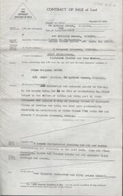
Document - H.A. & S.R. WILKINSON COLLECTION: CONTRACT OF SALE
This business was owned by father and son, Henry Archibald Wilkinson and Samuel Ronald "Ron" Wilkinson. Henry (1882-1954) was born in Shepparton and died in Bendigo. He was married to Grace Hovendon in 1908. Samuel Ronald "Ron" (1914-1995), Henry's son, was married to Florence Jean McKerlie in 1937.Contract of sale of land dated 10th February, 1956 between Mr. T.J.K. Gilbert (seller) and Mr. L.F. Rule (buyer) for land being allotment 14p section L, containing 19 acres 3 roods and being land described in certificate of title volume 6375 folio 936 and situate Marong Road, Bendigo. Together with all buildings thereon, also piping and loose galvanized iron on ground, with State Rivers and Water Supply Authority to irrigate 1 acre land. Price 650 pounds. Also attached a letter in two copies signed by Mr. Rule agreeing to the purchase, the letter is dated 7th February, 1956 and is on H.A & S.R. Wilkinson letterhead.organization, business, h.a. & s.r wilkinson real estate -
 Bendigo Historical Society Inc.
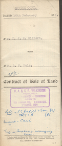
Document - CONVEYANCE DOCUMENTS FOR R. H. S. ABBOTT
Conveyance document for sale of land from Dr. James Boyd to Richard Hartley Smith Abbott. Dated 21.6.1900. Sale of three blocks of land for the sum of six hundred and fifty pounds. a. Allotment 6 of Section 8C b. Allotment 14 of Section 8C c. Allotment 13 of Section 8C -
 Southern Sherbrooke Historical Society Inc.
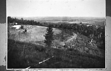
Photograph - Puffing Billy line near The Tanks
B&W photo of the Puffing Billy line near The Tanks below Glen Park Farm. On the left is the house of the Dunham family, with shedding in the background. The land slopes down to the track then falls quite steeply away to a treed area. In the distance can be seen land which is now part of Cardinia Reservoir. -
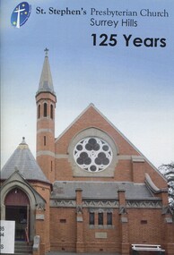 Surrey Hills Historical Society Collection
Book, St Stephen's Presbyterian Church Surrey Hills 125 years
This brief description of St. Stephen's Presbyterian church, Surrey Hills, on the corner of Canterbury and Warrigal Roads, Surrey Hills, dates back to 1887 when Surrey Hills was a settled emerging community. It documents the changes from then, including the land and buildings, their ministry, hymn books and bibles, church camps, mission work, PMWU, men's activities, outreach groups, multi-cultural groups until 2012.This brief description of St. Stephen's Presbyterian church, Surrey Hills, on the corner of Canterbury and Warrigal Roads, Surrey Hills, dates back to 1887 when Surrey Hills was a settled emerging community. It documents the changes from then, including the land and buildings, their ministry, hymn books and bibles, church camps, mission work, PMWU, men's activities, outreach groups, multi-cultural groups until 2012.(mr) j. k. blogg, 1887, surrey hills, (mr) (rev) john ewing, (mr) (rev) alexander mcdonald, (mr) (rev) frederick darling, surrey college, kleppers orchard, balmoral crescent, st. stephen's presbyterian church, uniting church, (mr) (rev.) david innes, (rev) w. howden, (mr) (rev) david bradshaw, churches, canterbury road, warrigal road -
 Kew Historical Society Inc
Plan - Subdivision Plan, Oswinia Estate, East Kew, c.1925
Prue Sanderson, in her groundbreaking ‘City of Kew Urban Conservation Study : Volume 2 - Development History’ (1988), summarised the periods of urban development and subdivisions of land in Kew. The periods that she identified included 1845-1880, 1880-1893, 1893-1921, 1921-1933, 1933-1943, and Post-War Development. These periods were selected as they represented periods of rapid growth or decline in urban development. An obvious starting point for Sanderson’s groupings involved population growth and the associated economic cycles. These cycles also highlighted urban expansion onto land that was predominantly rural, although in other cases it represented the decline and breakup of large estates. A number of the plans in the Kew Historical Society’s collection can also be found in other collections, such as those of the State Library of Victoria and the Boroondara Library Service. A number are however unique to the collection.Subdivision plans are historically important documents used as evidence of the growth of suburbs in Australia. They frequently provide information about when the land was sold on which a built structure was subsequently constructed as well as evidence relating to surveyors and real estate and financial agents. The numerous subdivision plans in the Kew Historical Society's collection represent working documents, ranging from the initial sketches made in planning a subdivision to printed plans on which auctioneers or agents listed the prices for which individual lots were sold. In a number of cases, the reverse of a subdivision plan in the collection includes a photograph of a house that was also for sale by the agent. These photographs provide significant heritage information relating house design and decoration, fencing and household gardens.The ‘Oswinia Estate’ subdivision in East Kew was planned and auctioned in the first half of the 1920s. 169 allotments were created in the triangular section of land bordered by High Street, Burke Road and the Government Boulevard (later Kilby Road). The only piece of land excluded was that where the previous Kew Pound had been located at the east tip of the triangle. Allotments were created fronting Glass, High, Namur, Oswin Streets, Irymple Avenue, and the Government Boulevard. The name for the Estate was derived from Oswin’s farm, which had been one of the largest landholdings in East Kew. The selling agents annotated the plan in our collection with crosses indicating those lots that had been sold. The inset locality plan is particularly interesting as it shows the route and stations of the Outer Circle Railway. When the subdivision plan was created, it included the proposed bridge over the Yarra at Burke Road. The bridge was to be officially opened in 1926.subdivision plans - east kew, oswinia estate, high street, glass street, namur street, government boulevard - kilby road, irymple street, oswin street -
 Melbourne Legacy
Document - Report, Ownership and lease of permanent camp at Balnarring, 1932
Documents concerning Legacy having a legal hold over land owned by Sir Stanley Savige in Balnarring in order to erect permanent camp buildings. 00253.1 and .2 Report of Meeting of sub committee considering the questions of title re permanent camp building at Balnarring. Meeting held at Hotel Austalia 2nd October 1929. Legatees Armstrong, Carleton, Tregent, Hall and Massey in attendence. 00253.3 Signed letter from Charles H. Peters to Brian Armstrong, Messers Plante and Henty Solicitors. 00253.4, .5, .6, .7, .8 Report on Balnarring Camp Property. Same as collection item 00250 but with different corrections and additional notes. 00253.9 Cover letter to L Armstrong signed from Dudley Tregent. 00253.10 Letter to Blatchford, Deputy Chairman Junior Legacy Club from unknown author. 00253.11, .12 Minutes of Meeting of Board of Management. Camp Premises Agreement and negotiations mentioned on page 3. Melbourne Legacy provides camps for junior legatees. The camps gave the children an opportunity of a summer beach holiday with other Legacy children. It started with camps on the property of Legacy founder, Legatee Stan Savige, who had a place in Balnarring, close to the beach. Permanent camp buildings were built in 1930. These documents relate to those buildings. Legacy Somers Camps continued intermittently at Stan's property until it was decided in 1951 to make other arrangements for holidays. Including two other camps in the Somers area: Lord Somers Camp and the Somers School Camp (owned by the Education Department). Camps provided for junior Legatees have been very important from early in Legacy's history. In the 1920s Legacy started camps at Stan Savige's property at Balnarring. By the 1930s a permanent camp kitchen and building had been built at Somers Camp. These documents relate to the official status of the property.White paper with black type x 12 pages relating to land ownership and lease questions around the Balnarring Camp. Six sets of documents kept together. Total of twelve pages, some double sided.land transfer, deed of trust, option to purchase, properties, savige property, legacy somers camp -
 Kew Historical Society Inc
Photograph - Flooding of the Yarra Valley at Kew East, 1974
Flooding of the Yarra Valley, including that section of the Yarra bordering Kew and Kew East in the north and west of the municipality, was a regular occurrence. Extreme flood events of the Yarra River are recorded to have occurred in 1891, 1901, 1916, 1923 and 1934. The Municipality of Kew's response to these floods was to enact planning decisions restricting residential development in flood prone areas following the floods of 1916, 1921 and 1934. While floods continued after the development of the Upper Yarra Reservoir (construction 1948-57), the regularity and extent of these inundations diminished. During the nineteenth century, the land abutting the south side of the Yarra in Kew was devoted to dairy farming. In the twentieth century, before and after the construction of the Eastern Freeway, much of this low-lying area was used as golf courses and public parks.Late example of the capacity of the Yarra Valley at Kew to flood, even though drainage works and the Upper Yarra Reservoir had reduced their regularity.Original black and white print photograph of the low-lying land at East Kew under floodwater on 16 May 1974. The vantage point of the photographer is Lister Street. In the photo, the fences of the Kilby Farm can be seen. Flooding was caused by overflowing water in Glass' Creek and the River Yarra. Annotation verso: "Hay's Paddock op No.30 Lister Street / 16 May 1974 11.50am / R.L. 46.04"hays paddock, floods, yarra river, glass' creek, lister street -
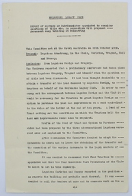
 Surrey Hills Historical Society Collection
Photograph, Hamilton Street, Mont Albert in 1919, 1919
The land occupied by the Hamilton Street shops was subdivided in the 1880s and the first purpose-built shop was 'Pope and Moran, Grocers'. This shop later became Tom Morris' Grocery. By 1930 shops stretched along both sides of Hamilton Street and part way along Churchill Street. The donor the late Norman Carter took many photos documenting Mont Albert and Surrey Hills from the 1920s. His subject matter often related to Church of England events and activities.Black and white photo taken from the centre of the road in Hamilton Street, Mont Albert. Three single storey shops can be seen with vacant blocks of land in between them. They have verandas extending over the pavement to the edge of the road which appears to have bluestone curb and channelling. One shop sells dairy produce and small goods.hamilton street, shops -
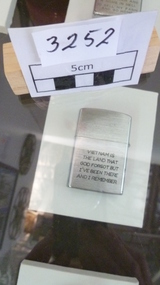 National Vietnam Veterans Museum (NVVM)
Functional Object - Cigarette Lighter
Silver lighter with inscription engraved.Vietnam is the land that God forgot, but I've been there and I remember: Vietnam 70-71 Saigon B-52H Bomberzippo lighter, b52 -
Kew Historical Society Inc
Journal - Visitor Book, Fairyland 1959-1960
"Fairyland", the home of Jim and Grace Tabulo, was a major local, state and international tourist attraction situated in Kew, Victoria during the mid twentieth century. Located at 57 Malmsbury Street, Kew, the weatherboard house and its garden were heavily decorated with statues, crockery and other collected items. A series of notebooks were used to record the messages of child and adult visitors to the property from the 1940s to the 1960s. After Mrs Tabulo's death, these visitor books are believed to have formed part of the Dorothy Rogers Collection. They entered the Kew Historical Society's collection following her death in 1973.This series of visitor books are the most important primary sources relating to the internationally renowned 'Fairyland' cottage in Malmsbury Street, Kew. Their social significance is that they record in the post war period the values and beliefs of children and adults who visited this historically significant tourist attraction.Foolscap visitor book and containing handwritten comments and drawings primarily made by children during visits to the home of Grace Tabulo, May 1959- August 1960. Commonly known as "Fairyland", the house was located at 57 Malmsbury Street Kew. The book is wrapped in brown paper, which covers blue and red card covers with green cloth strip binding. Several pages of the book have entries which have been made upside-down. Unpaginated, 80pp. Handwritten on paper front cover: "1959 / 1960" Handwritten inside cover: "Fairy Land / 57 Malmsbury St/ Kew""grace tabulo, fairyland - 57 malmsbury street (kew), tourism - kew - 1945-1965, childhood - kew, collectors and collecting, gardens - kew (vic), scrapbooks - 20th century -
 National Vietnam Veterans Museum (NVVM)
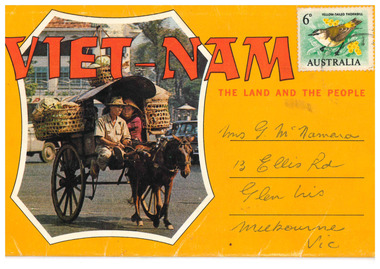
Postcard - Postcard -Foldout booklet, Asia-Pacific Color Productions Ltd
Deep yellow/orange with red print. Green postage stamp featuring yellow-tailed Thornbill. Postcard contains 14 pictures of Vietnamese people and places. Front page shows picture of couple in a horse-drawn two wheeled cart having two luggage baskets and sunshade.Viet-Nam The Land and the People Addressed to - Mrs. G McNamara / 13 Ellis Road / Glen Iris / Melbourne Vicpostcard, mcnamara, julian peter mcnamara, australian army, 3794332, trooper, royal australian armoured corps, national service, b squadron, a squadron, 1st armoured regiment -
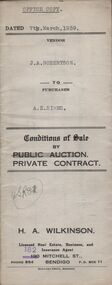 Bendigo Historical Society Inc.
Document - H.A. & S.R. WILKINSON COLLECTION: CONTRACT OF SALE
Conditions of sale by private contract dated 7th March, 1939 between J.A. Robertson (seller) and A.E. Simms (buyer) for land situate Prowse Road, Bendigo, at present occupied by Mrs. Harbour as tenant, being the land described in right to occupy residence area No. 190. Also all the vendor's right, title and interest to the land as fenced adjoining the above mentioned property, together with 5-roomed weatherboard dwelling and all sundry. Price 250 pounds. Attached copy of application to register a Lienorganization, business, h.a. & s.r wilkinson real estate -
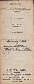 Bendigo Historical Society Inc.
Document - H.A. & S.R. WILKINSON COLLECTION: CONTRACT OF SALE
Conditions of sale by private contract dated 4th April, 1933 between E.M. Dudley (seller) and C.J. Tyack for land situate No.161 honeysuckle street, Bendigo being land described in certificates of registration as residence area no. 32525 and residence area no. 32526, together with 6-roomed weatherboard dwelling, garage and all sundry outbuildings and erections on said land. Also all electric light fittings, duck blinds in sleep-out, all wire doors and windows, window blinds and name plate. Price 545 pounds.organization, business, h.a. & s.r wilkinson real estate -
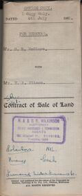 Bendigo Historical Society Inc.
Document - H.A. & S.R. WILKINSON COLLECTION: CONDITION OF SALE
Contract of sale of land dated 4th July, 1952 between Mr. D. R. McClure (seller) and Mr.. H. A. Pitson for land described in right to occupy residence area No. 9508, together with all buildings and erection thereon, also all sundries inside and outside the building. Price 60 pounds. Also attached various receipt from Department of lands and survey, copy of the right to occupy land issued in 1942, letter from the City of Bendigo dated in 1951 drawing attention to unpaid rates on the property.organization, business, h.a. & s.r wilkinson real estate -
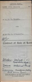 Bendigo Historical Society Inc.
Document - H.A. & S.R. WILKINSON COLLECTION: CONDITION OF SALE
Contract of sale of land dated 29th January 1954 between Mr. E.M. Hopper (seller) and Mr. G.J. O'Donnell (buyer) for land being Lot 2 on plan of subdivision No. 23332 registered in the office of titles, Melbourne and situate in Lindsay Street Kangaroo Flat part of Crown allotment 11 section 23, township of Kangaroo Falt described in Certificate of title volume 7446 folio 423, together with weatherboard dwelling, wood shed-lavatory also fencing on the said land. Price 2,700 pounds.organization, business, h.a. & s.r wilkinson real estate -
 Bendigo Historical Society Inc.
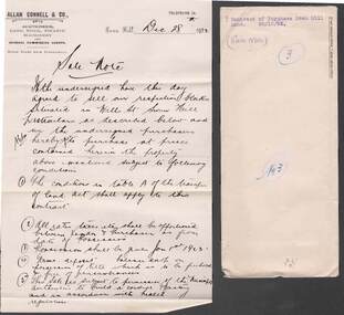
Document - COHN BROTHERS COLLECTION: CONTRACT TO PURCHASE SWAN HILL LAND
[a] Manilla envelope with Cohn Victoria Brewery printed on reverse flap. Typed front caption 'Contract of Purchase Swan Hill Land. 28/12/22, Handwritten No 3 , and Sale Note. [b] Handwritten sale note on Allan Connell & Co Swan Hill Auctioneer printed paper dated Dec 28th 1922, specifying sale conditions and particulars of land. [c] Handwritten particulars of land owned by O G Burton and sold to Cohn's for proposed cordial factory site. £305 purchase amount.bendigo, industry, cohn bros brewery -
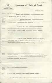 Bendigo Historical Society Inc.
Document - H. A. & S. R. WILKINSON COLLECTION: CONTRACT OF SALE
Contract of sale of land dated 27th February, 1964 between Mr. Edward John Hynam (vendor) and Mr. M.F. Sexton (purchaser). Solicitor for vendor: Watson, James & Rogers, Bull Street, Bendigo. Solicitor for purchaser: E.S. Cahill& Son, View Street, Bendigo. Property 51 King Street, Bendigo, land being part of Crown allotment 22 section 52C land comprised in certificate of title volume 4445 folio 974 including floor coverings, curtains and blinds. Price: 1,800 pounds.organization, business, h.a. & s.r wilkinson real estate