Showing 2910 items matching "australian maps"
-
 Ballarat Heritage Services
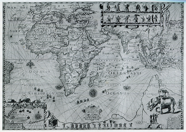
Map, Plancius's Map (Amsterdam), 1594, 1594
Copy of a Dutch map published in Amsterdam. showing a large stretch of outhern land called Terra sustralis Copy of a map from 'A Short HIstory of Australia' by Ernest Scott.map, plascius, placius's map, terra australis, dutch map -
 Ballarat Heritage Services
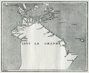
Map, Map of Java La Grande, 1542, 1542
... from 'A Short HIstory of Australia' by Ernest Scott. Map ...Copy of a map from 'A Short HIstory of Australia' by Ernest Scott.map, chart of the southland, hessel gerritsz, dutch discovery of australiaj.e heres het aandael -
 Ballarat Heritage Services
Map, Map Illustrating Voyage of Ban Neck's Fleet to Dutch East Indies, 1598-1600, 1598-1600
... of a map from 'A Short HIstory of Australia' by Ernest Scott. Map ...Copy of a map from 'A Short HIstory of Australia' by Ernest Scott.map, van neck's fleet, dutch east indies -
 Ballarat Heritage Services
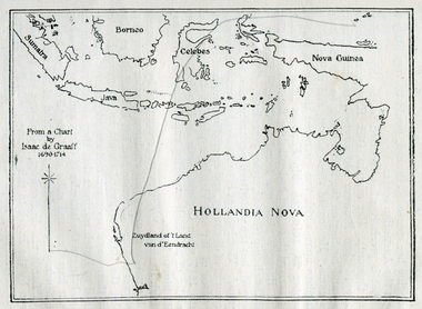
Photograph - Map, Map of New Holland from a chart by Isaac de Graaf (1690-1714), c1714
... from 'A Short HIstory of Australia' by Ernest Scott. Map of New ...Copy of a map from 'A Short HIstory of Australia' by Ernest Scott.map, new holland, hollandia nova, isaac de graaff, new guinea, australia of the holy spirit, papua, new hebrides, new zealand, nuyts land, van dieman's land, tasman's track -
 Ballarat Heritage Services
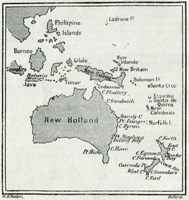
Map, New Holland and New South Wales as Known after Cook's Voyages
Copy of a map from 'A Short HIstory of Australia' by Ernest Scott.map, explorers, exploration, new holland, norfolk island, point hicks, timor -
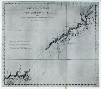 Ballarat Heritage Services
Photograph - Map, Portion of Captain James Cook's Chart of New South Wales, 1770, 1770
Copy of a map from 'A Short HIstory of Australia' by Ernest Scott.map, explorers, exploration, voyages, captain james cook, new south wales coast -
 Ballarat Heritage Services
Map, Map of Abel Tasman's Voyages, 1642-1644
... Copy of a map from 'A Short HIstory of Australia' by Ernest ...Copy of a map from 'A Short HIstory of Australia' by Ernest Scott.map, explorers, exploration, abel tasman, voyages -
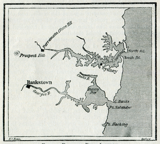 Ballarat Heritage Services
Map, Botany Bay and Port Jackson
Copy of a map from 'A Short HIstory of Australia' by Ernest Scott.map, explorers, exploration, voyages, new south wales coast, port jackson, botany bay bankstown, prospect hill, parramatta, rose hill, sydney -
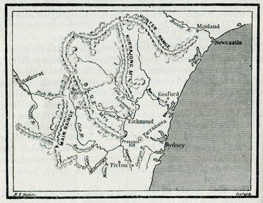 Ballarat Heritage Services
Map, The Blue Mountains, New South Wales
Copy of a map from 'A Short HIstory of Australia' by Ernest Scott.map, explorers, exploration, new south wales coast, parramatta, sydney, gosford, maitland, newcastle, blue mountains, picton -
 Ballarat Heritage Services
Photograph - Map, Freycinet's Map, Showing 'Terre Napoleon'
... napoleon australia Copy of a map from 'A Short History of Australia ...Copy of a map from 'A Short History of Australia' by Ernest Scott.map, explorers, exploration, freycinet, terre napoleon, australia -
 Ballarat Heritage Services
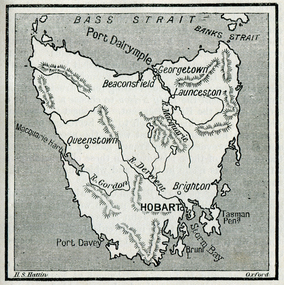
Photograph - Map, Hobart and Port Dalrymple
Copy of a map from 'A Short History of Australia' by Ernest Scott.map, explorers, exploration, bass straight, hobart, port davey, georgetown, beaconsfield, queenstown, gordon rover, derwent river, launceston, port dalrymple, banks straight, macquarie harbour, maps, plans -
 Ballarat Heritage Services
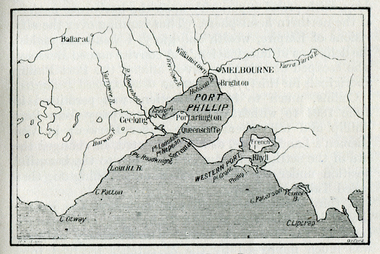
Map, Westernport and Port Phillip
Copy of a map from 'A Short History of Australia' by Ernest Scott.map, explorers, exploration, westernport, port phillip, queenscliffe, melbourne, brighton, williamstown, port arlington, hobson bay, cape otway, geelong, barwon river, ballarat, yarra river, yarra yarra river -
 Ballarat Heritage Services
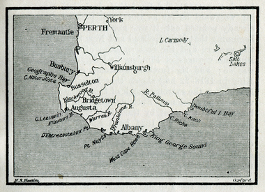
Map, King George's Sound
Copy of a map from 'A Short History of Australia' by Ernest Scott.map, explorers, exploration, king george's sound, perth, fremantle, bunbury, busselton, bridgetown, albany, york, williamsburgh -
 Ballarat Heritage Services
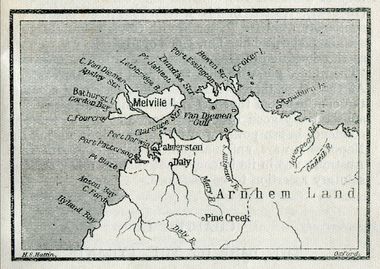
Map, Melville Island
Copy of a map from 'A Short History of Australia' by Ernest Scott.map, explorers, exploration, melville island, tiwi islands, arnhem land, palmerston, daly, croker island, bathurst island, pine creek, daly river -
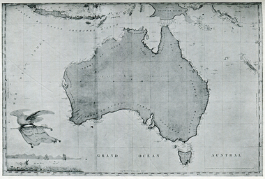
 Ballarat Heritage Services
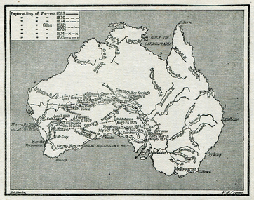
Map, Australian Inland Exploration, 1815-1928, 1815-1828
... Office goldfields map explorers exploration australian alps ...Copy of a map from 'A Short History of Australia' by Ernest Scott.map, explorers, exploration, australian alps, westernport, port phillip, hume and hovell, oxley, evans, cunningham, darling downs, liverpool -
 Ballarat Heritage Services
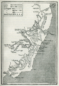
Map, Exploration of Eyre, Sturt, Stuart, Gregory, Burke, and Wills
Copy of a map from 'A Short History of Australia' by Ernest Scott.map, explorers, exploration, burke and wills, sturt, stuart, gregory, melbourne, perth, sydney, mitchell river, a.c. gregory, darling river, lachlan river, mt stuart, murray river -
 Ballarat Heritage Services
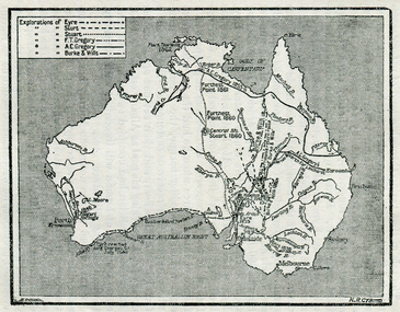
Map, Exploration of Eyre, Sturt, Stuart, Gregory, Burke, and Wills
Copy of a map from 'A Short History of Australia' by Ernest Scott.map, explorers, exploration, stuart, gregory, melbourne, perth, sydney, darling river, murray river, adelaide, albany, fitzroy river, flinders river, brisbane, great australian bight, gulf of carpentaria, mount grey, forrest -
 Ballarat Heritage Services
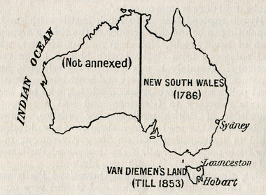
Map, Australian Colonies (States), c1918
... Office goldfields map australia indian ocean van dieman's land ...Copy of a map from 'A Short History of Australia' by Ernest Scott published in 1918. map, australia, indian ocean, van dieman's land, tasmania, new south wales, sydney, western australia, perth, albany, launceston, hobart, south australia, melbourne, townsville, rockhampton, brisbane, northern territory, queensland -
 Ringwood RSL Sub-Branch
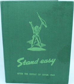
Book, Stand Easy, 1945
Hard cover with 205 pages containing hand written prints etc with list of contributors. Contains maps supplements.After the defeat of Japan 1945. Published by Australian War Memorial Canberra ACT 1945. -
Unions Ballarat
In step with Sturt (Don Woodward Collection), Swan, Keith et al, 1979
The book, targeted at school students, covers the years of Sturt's three expeditions. The authors question Sturt's capability as a surveyor and his leadership.Australian history.Graphic book; 115 pages. Dustjacket: plastic covering; brown and white background; black and white map of Sturt's journey along Murrumbidgee and the Murray River; black, gold and white lettering; authors' names and title. Cover: white and black lettering; authors' names and title.btlc, ballarat trades and labour council, ballarat trades hall, sturt, charles, history - australia, australia - explorers -
 Ballarat Heritage Services
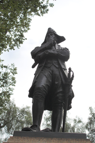
Photograph - Photograph - Colour, Clare Gervasoni, Statue of Matthew Flinders, Adelaide, 2000, 01/01/2000
A number of photographs of a statue of explorer Matthew Flinders, and maps of the coastline of Australia and South Australia. matthew flinders, explorer, south australia -
Hume City Civic Collection
Booklet - Melbourne Airport
A paperback booklet with a cardboard cover with folding flap on the inside of the front and backnon-fictionmelbourne airport, aviation, airports, tullamarine -
 RMIT Design Archives
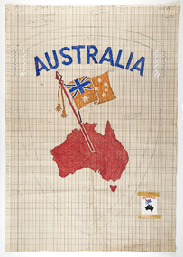
Mixed media - Drawings, Design for clothing label featuring map of Australia
... Design for clothing label featuring map of Australia... attached Design for clothing label featuring map of Australia Mixed ...Cash's first began manufacturing name tags, woven badges and woven labels in Australia in 1913, and since then countless Cash's labels have been sewn onto school and club jumpers. Point paper design featuring map and flag. Corresponding clothing label attachedtextile design, rmit design archives -
 Parliament of Victoria
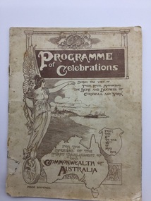
Programme, Official programme of functions and displays to celebrates the opening of the first Parliament of the Commonwealth of Australia by His Royal Highness the Duke of Cornwall and York, at Melbourne, 1901
Programme of celebrations during the visit of their Royal Highnesses the Duke and Duchess of Cornwall and York for the opening of the first Parliament of the Commonwealth of Australia from the 6th to the 16th May 190148 pages : illustrations, maps, portraits -
 Numurkah & District Historical Society
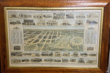
Map - Print in frame - Numurkah Township 1888, Supplement to the "Numurkah Standard" January 1888 View of Numurkah Victoria Australia
... grandson numurkah standard, numurkah township map, numurkah ...The late Hilda Morieson (very active in early Historical Society) owned the print. It was then passed on to Mary Morieson, then to Rosemary Kennet. It has been passed onto the Historical Society with permission from Ben Morieson, Hilda's grandsonLarge coloured print of supplement to Numurkah Standard 1888. Artist's view/impression of Numurkah streets (map) surrounded by artwork of a number of Numurkah businesses in the town and local district. The print is under glass in a faux-wood-grained framesee photo abovenumurkah standard, numurkah township map, numurkah businesses, 1888, print -
 Numurkah & District Historical Society
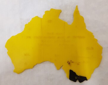
Equipment - Plastic stencil map/shape of Austalia
Yellow plastic stencil in the shape of Australia, states marked on the map, Victoria painted in blackState Savings Bank of Victoraeducation, school, geography, australia, stencil, drawing -
 Ballarat RSL Sub-Branch Inc.
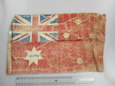
Flag - Australian Red Ensign (sm)
With map showing "Famous battle-fields of the Australian Forces" printed overfirst world war (ww1), 1914 - 1918, flags, ballarat rsl, ballarat -
 Ballarat RSL Sub-Branch Inc.
Map - Framed "Tobruk Siege"
Australian Positions as at 1 May 1941photo/pictures, ballarat rsl, ballarat -
 Tramways/East Melbourne RSL Sub Branch - RSL Victoria Listing id: 27511
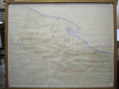
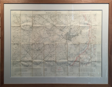
Map and Legend, Trench Map - France Sheet 36 N.W
... This is an actual battle map used by Australian Forces... This is an actual battle map used by Australian Forces in the battle ...This is an actual battle map used by Australian Forces in the battle of the Somme in France in April 1917. It is an ordinance survey map of the trenches in the area. It is framed in two pieces, one being the main map and the other the legend used to read the map. It details the river 'La Lys Riviera' and the city 'Armentieres', in the Somme. somme, trench map, ww1, belgium, france, armentieres, 1917, ordinance survey map -
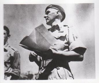 8th/13th Victorian Mounted Rifles Regimental Collection
Photograph - WO2 Ernie Grant
The 8th/13th Victorian Mounted Rifles was raised as a regiment of the Royal Australian Armoured Corps on 1 May 1948 with Headquarters in Melbourne and squadrons in Sale, Benalla/Wangaratta and Albury. In 1955 Regimental Headquarters moved to Wangaratta and a second squadron was located at Albury. The Sale squadron transferred to 4th/19th Prince of Wales’s Light Horse. In 1977 8/13 VMR Regiment was reduced to an independent squadron A Squadron 8th/13th Victorian Mounted Rifles and in 1991 was linked with 4th/19th Prince of Wales’s Light Horse forming the VMR Squadron of that regiment.Unique collection of photographs showing the first years of an armoured regiment of the post-Second World War era Citizen Military Forces showing equipment, uniforms, training and social activity and some personalitiesBlack and white photograph of soldier with map, Khaki drill uniform, w3b belt, beret, service ribbons.One of a collection of photographs of 8th/13th Victorian Mounted Rifles Regiment between 1948 and 1951.WO 11 Ernie Grantuniform, royal australian armoured corps, grant