Showing 2065 items matching "crossings"
-
 Eltham District Historical Society Inc
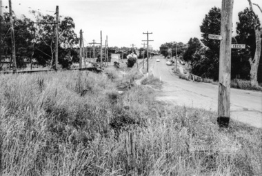
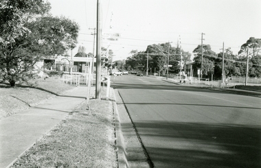
Photograph, Looking north along Main Road from Diamond Street Railway Crossing at intersection with Cecil Street, Eltham, February 1968, Feb 1968
Cecil Street to the right.In February 1968 an unknown person took a series of photos from the Eltham Hotel at Pitt Street heading north along Main Road through the shopping centre to just north of Elsa Court covering the length of the section of Main Road which was duplicated shortly thereafter. Shows the condition and environment of the streesscape of Main Road, Eltham immediately prior to the duplication between Pitt Street and Elsa Court through the shopping centre. Also shows a number of shops and businesses that operated at that time.Black and white photographduplication, eltham, main road, cecil street, diamond street, railway line -
 Eltham District Historical Society Inc
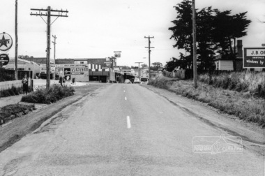
Photograph, Looking south along Main Road from Diamond Street Railway Crossing, Eltham, February 1968, Feb 1968
Luck Street enters Main Road from the left behind the Caltex garage. Note the house on right hand land.In February 1968 an unknown person took a series of photos from the Eltham Hotel at Pitt Street heading north along Main Road through the shopping centre to just north of Elsa Court covering the length of the section of Main Road which was duplicated shortly thereafter. Shows the condition and environment of the streesscape of Main Road, Eltham immediately prior to the duplication between Pitt Street and Elsa Court through the shopping centre. Also shows a number of shops and businesses that operated at that time.Black and white photographduplication, eltham, main road, diamond street, railway line, railway crossing, caltex service station, supa-value self service -
 Eltham District Historical Society Inc
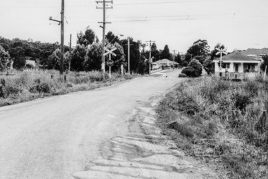
Photograph, Looking east along Diamond Street to the railway crossing near intersection with Main Road, Eltham, February 1968, Feb 1968
Shows houses on Main Road and Cecil Street across Main Road from Diamond Street.In February 1968 an unknown person took a series of photos from the Eltham Hotel at Pitt Street heading north along Main Road through the shopping centre to just north of Elsa Court covering the length of the section of Main Road which was duplicated shortly thereafter. Shows the condition and environment of the streesscape of Main Road, Eltham immediately prior to the duplication between Pitt Street and Elsa Court through the shopping centre. Also shows a number of shops and businesses that operated at that time.Black and white photographduplication, eltham, main road, diamond street, railway line, railway crossing, cecil street, judge book village -
 Eltham District Historical Society Inc
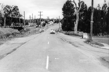
Photograph, Looking north along Main Road from intersection with Cecil Street, Eltham, February 1968, Feb 1968
In February 1968 an unknown person took a series of photos from the Eltham Hotel at Pitt Street heading north along Main Road through the shopping centre to just north of Elsa Court covering the length of the section of Main Road which was duplicated shortly thereafter. Shows the condition and environment of the streesscape of Main Road, Eltham immediately prior to the duplication between Pitt Street and Elsa Court through the shopping centre. Also shows a number of shops and businesses that operated at that time.Black and white photographduplication, eltham, main road, railway line, railway crossing, cecil street -
 Eltham District Historical Society Inc
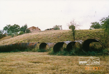
Photograph, Pipes used for original aqueduct crossing of Diamond Creek, Allendale Road, Eltham, 22 March 1991, 22/03/1991
Colour photographmaroondah aqueduct, allendale road -
 Eltham District Historical Society Inc
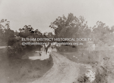
Photograph, Diamond Creek in flood over Glen Park Bridge, Eltham, c. 26 August 1924
Significant flooding of the Diamond Creek occurred in Eltham and Glen Park on Tuesday, August 26, 1924 with several houses swamped and all bridges covered except the Greensborough Road Bridge. [Houses at Eltham Flooded. (1924, August 27). The Argus (Melbourne, Vic. : 1848 - 1957), p. 19. Retrieved from http://nla.gov.au/nla.news-article4156891] The Glen Park Bridge was originally built as a replacement for an older private bridge built by a man named Foley around 1880. In 1911 Heidelberg and Eltham agreed to share the costs to build a new bridge. Construction began in June 1915 and it was officially opened by Cr. Taylor on Cup Day, November 1915. The bridge was destroyed by floodwaters in the afternoon of 20 September 1959 during construction of the new Wattletree Road bridge. The new bridge west embankment joined the existing road at approximately where the bend in the road is situated in the photograph.Colour photograph of originalfloods, eltham, diamond creek (creek), egan's crossing, eltham-diamond creek road, glen park bridge, glen park road -
 Eltham District Historical Society Inc
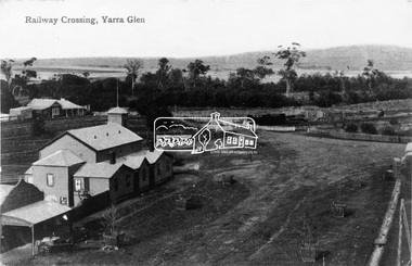
Photograph, Railway Crossing - Yarra Glen
Source: Royal Historical SocietyThis photo forms part of a collection of photographs gathered by the Shire of Eltham for their centenary project book,"Pioneers and Painters: 100 years of the Shire of Eltham" by Alan Marshall (1971). The collection of over 500 images is held in partnership between Eltham District Historical Society and Yarra Plenty Regional Library (Eltham Library) and is now formally known as the 'The Shire of Eltham Pioneers Photograph Collection.' It is significant in being the first community sourced collection representing the places and people of the Shire's first one hundred years.Digital imagesepp, shire of eltham pioneers photograph collection, yarra glen, railway crossing -
 Ringwood and District Historical Society
Photograph, Bedford Rd Railway Crossing Siding Construction, Ringwood, Late 1980 (2 Views)
Written on back of photographs, "Late 1980. Bedford Road railway siding construction." -
 Australian Commando Association - Victoria
Book - Pamphlet, Crossing the Rip. The Commando Raid on Point Nepean
-
 Ringwood and District Historical Society
Photographs, Ringwood East Railway Crossing on Dublin Road in 1999
-
Marysville & District Historical Society
Document (Item) - Report, John F. Waghorn, Yarra Track, Unknown
A report on the history of the Yarra Track by John Waghorn, a local amateur historian.A report on the history of the Yarra Track by John Waghorn, a local amateur historian. John Waghorn was an amateur historian, an authority on the history of Victoria's postal services. He could tell you how mail was delivered in the high country in the 1880s, where the town of Gobur was, or when the overland Melbourne-Sydney mail service began. He admitted that his hobby has got a little out of hand. He had 30 filing cabinets, and indexes of more than 70,000 postal workers over the past 160 years crammed into three rooms at his home. If an ancestor was a postmaster in a Victorian town, he may have been able to reveal the person's occupation, income and working conditions.yarra track, john waghorn, victoria's postal services, wood's point, sydney road, longwood, merton, mansfield, postmasters, bonnie doon, melville merton mansfield, eltham, healesville, marysville, walhalla, melbourne-warburton-wood's point line, loose bags, heidelberg post office, eltham post office, kangaroo ground post office, yarra glen post office, marysville post office, healesville post office, mansfield post office, jamieson post office, gaffney's creek post office, wood's point post office, postal department, george rieck, stockman, jones, beecher, stockman's reward, big river, mary mcdonald, upper yarra river, donovan's creek, cornelius donovan, bridget buggy, matlock, alexandra, william farrell, jordan diggings, new chum, watts river, black spur, narbethong, granton, acheron river, mount strickland, paradise plains, mount grant, mount arnold, jordan goldfields, william robley, robley's spur, big river crossing, great dividing range, cumberland valley, james mcguigan, w elliot, christopher harrison, james marsh, cobb and co, box hill, lilydale, fehrings, koehlers, shaws, bear creek, cairnsville, cumberland creek, walkers, golden bower mine, collins' mountain home hotel, walsh's creek post office, rosa mcveigh, frank barton, hitchins, matthew kennedy, william morris, e r nichols, t woods, tom burchell, peter kerr, henry kuyper, william podlech, george koehler, henry brockmann, henry petty, thomas smith, jacob butchart, john perry, slingsby davis, royal mail hotel, walter gray, john summers, travellers rest hotel, lockington, the oaks, the springs, st clair, thomas crawford, springvale hotel, john sinclair, saint clair hotel, gould, mathews, willie we have missed you hotel, germany, johan fehring, adelaide, linton, ballarat, gunbower, murray river, anna katerina fehring, 1890s depression, land boom, fehring place, fred baker, alf sparke, fehring's hotel, mcveigh's hotel, wood's point mountaineer, l cox, victorian country directories, letson cox, coburg, maria hayes, setson, fitzroy, richmond, john cox, jordan river, jericho, e. norris, le poidevin, newell, o'brien, alhambra, sinclair, parker, ellis, tripp, quin, vernon, thompson, charsley, james fahie, george locke, william chester, chesterville, kirwan, cumberland reserve, blue spruce, e.s. and a bank, selby joyce, selby charles joy, selby joseph joyce -
 Marysville & District Historical Society
Photograph (Item) - Black and white photograph, Fernshaw, c1900
An early black and white photograph taken at Fernshaw.An early black and white photograph taken at Fernshaw. Fernshaw was a rural township 63 km north-east of Melbourne and 10 km north-east of Healesville. Situated on the Watts River, near where a log had fallen making a convenient crossing, Fernshaw was settled in the 1860s. It provided good country for orchards and berry growing. The location was at the foot of Blacks Spur, with Mounts Juliet and Mondah rising on either side, providing spectacular scenery. There were nearby fern gullies giving rise to the name – ‘shaw’ is old English for thicket or wood. By 1875 Fernshaw had a post office (1865), two hotels, a school (1871) and stores. It was famed for its beauty, attracting tourists. In 1886 the Melbourne and Metropolitan Board of Works began work on the Watts River water catchment scheme – later to become Maroondah – and the Board obtained approval for the catchment country to be reserved and kept free of settlement. This required the removal of the Fernshaw township, which was completed by about 1890. The area was described in the 1903 Australian handbook:ARMSTRONG COLLECTION 42 STATION STREET/ SANDRINGHAM 3191/ TEL. (03) 9521 5442/ IAN M.L. ARMSTRONG OAMfernshaw, healesville, watts river, orchard, berry orchard, blacks spur, black spur, mount juliet, mount mondah, maroondah dam, victoria -
 Marysville & District Historical Society
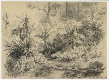
Artwork, other (Item) - Pencil Sketch, Louis Buvelot, Fernshaw 17.2.83, 1883
A copy of an early pencil sketch of Fernshaw in Victoria.A copy of an early pencil sketch of Fernshaw in Victoria by Louis Buvelot. Louis Buvelot ( 1814–1888), born Abram-Louis Buvelot, was a Swiss landscape painter who lived 17 years in Brazil and following 5 years back in Switzerland stayed 23 years in Australia, where he influenced the Heidelberg School of painters. Arriving in Melbourne in February 1865, after leaving the cold of Switzerland, which was impacting on his health, for the warmth of Australia, Buvelot was in business as a photographer in Bourke Street for a year but soon resumed his painting. He lived in Melbourne for a number of years before moving to Fitzroy. The National Gallery of Victoria purchased two of his paintings and he continued painting until his death in 1888. He was buried at the Boroondara Cemetery, where a large monument was erected in his memory. Fernshaw was a rural township 63 km northeast of Melbourne and 10 km northeast of Healesville. Situated on the Watts River, near where a log had fallen making a convenient crossing, Fernshaw was settled in the 1860s. It provided good country for orchards and berry growing. The location was at the foot of Blacks Spur, with Mounts Juliet and Mondah rising on either side, providing spectacular scenery. There were nearby fern gullies giving rise to the name – ‘shaw’ is old English for thicket or wood. By 1875 Fernshaw had a post office (1865), two hotels, a school (1871), and stores. It was famed for its beauty, attracting tourists. In 1886 the Melbourne and Metropolitan Board of Works began work on the Watts River water catchment scheme – later to become Maroondah – and the Board obtained approval for the catchment country to be reserved and kept free of settlement. This required the removal of the Fernshaw township, which was completed by about 1890.Fernshaw 17.2.83louis buvelot, fernshaw, victoria, national gallery of victoria, switzerland, boroondara cemetery, kew cemetery, artist -
 Marysville & District Historical Society
Painting (Item) - Oil painting, Isaac Whitehead, A spring morning near Fernshaw 1880, 1880
A copy of an early oil painting of Fernshaw in Victoria.A copy of an early oil painting of Fernshaw in Victoria by Isaac Whitehead. Isaac Whitehead (1819–1881) was an Irish-Australian artist who worked in watercolour and pastel. He was also a picture framer and art promoter. It is believed that Isaaz Whitehead emigrated to Australia with his family in either 1853 or 1858. Isaac Whitehead died at his home 50 Punt Road, Prahran, Melbourne, on 21 April 1881. Isaac Whitehead had established himself as the foremost picture framer in Melbourne by 1860, known for his highly ornate frames with floral decorations. Among the clients of his framing business were Louis Buvelot, Nicholas Chevalier, and Eugene von Guérard. In his own paintings, he painted a number of scenes of the forests of Gippsland, Victoria. His work focused on the rich landscapes with trees and ferns, with a high degree of botanical detail. His work won him two medals and his work was posthumously exhibited at 1884 Victorian Jubilee Exhibition, the 1886 London Colonial and Indian Exhibition, and the 1888 Melbourne Centennial Intercolonial Exhibition. Fernshaw was a rural township 63 km northeast of Melbourne and 10 km northeast of Healesville. Situated on the Watts River, near where a log had fallen making a convenient crossing, Fernshaw was settled in the 1860s. It provided good country for orchards and berry growing. The location was at the foot of Blacks Spur, with Mounts Juliet and Mondah rising on either side, providing spectacular scenery. There were nearby fern gullies giving rise to the name – ‘shaw’ is old English for thicket or wood. By 1875 Fernshaw had a post office (1865), two hotels, a school (1871), and stores. It was famed for its beauty, attracting tourists. In 1886 the Melbourne and Metropolitan Board of Works began work on the Watts River water catchment scheme – later to become Maroondah – and the Board obtained approval for the catchment country to be reserved and kept free of settlement. This required the removal of the Fernshaw township, which was completed by about 1890.isaac whitehead, fernshaw, victoria, louis buvelot, nicholas chevalier, eugene von guerard, gippsland, victorian jubilee exhibition, london colonial and indian exhibition, melbourne centennial intercolonial exhibition, watts river, healesville, blacks spur, mount juliet, mount mondah -
 Marysville & District Historical Society
Photograph (Item) - Black and white photograph, Fred Kruger, Scene on the Watts River near Fernshaw, Unknown
A copy of a black and white photograph on the Watts River near Fernshaw in Victoria.A copy of a black and white photograph on the Watts River near Fernshaw in Victoria taken by Fred Kruger. Fred Kruger (born Johan Friedrich Carl Kruger, 18 April 1831 – 15 February 1888) was a German-born photographer noted for his early photography of landscape and indigenous peoples in Victoria, Australia. Fernshaw was a rural township 63 km northeast of Melbourne and 10 km northeast of Healesville. Situated on the Watts River, near where a log had fallen making a convenient crossing, Fernshaw was settled in the 1860s. It provided good country for orchards and berry growing. The location was at the foot of Blacks Spur, with Mounts Juliet and Mondah rising on either side, providing spectacular scenery. There were nearby fern gullies giving rise to the name – ‘shaw’ is old English for thicket or wood. By 1875 Fernshaw had a post office (1865), two hotels, a school (1871), and stores. It was famed for its beauty, attracting tourists. In 1886 the Melbourne and Metropolitan Board of Works began work on the Watts River water catchment scheme – later to become Maroondah – and the Board obtained approval for the catchment country to be reserved and kept free of settlement. This required the removal of the Fernshaw township, which was completed by about 1890.fernshaw, watts river, victoria, fred kruger, photograph -
 Eltham District Historical Society Inc
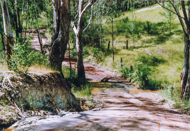
Photograph, Creek crossing, Rodger Road, Panton Hill, 6 December 1992, 06/12/1992
The Eltham Horse Trail: Research and Warrandyte to Kinglake: Survey of proposed route, December 1992: (3) Kangaroo Ground to KinglakeColour photographeltham horse trail (1992 survey), panton hill, rodger road -
 Eltham District Historical Society Inc
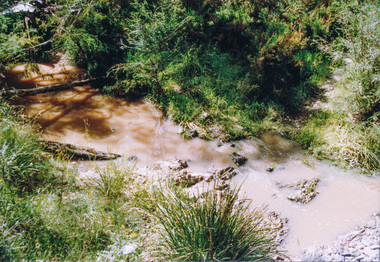
Photograph, Creek crossing, Long Gully Bushland Reserve, Panton Hill, 6 December 1992, 06/12/1992
The Eltham Horse Trail: Research and Warrandyte to Kinglake: Survey of proposed route, December 1992: (3) Kangaroo Ground to KinglakeColour photographeltham horse trail (1992 survey), panton hill, long gully road -
 Eltham District Historical Society Inc
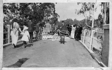
Photograph, Hurstbridge - Cr. Price crossing New Bridge (Opening Day), 1917, 1917
Eltham Shire Councillor Albert Price joined over 500 spectators for the official opening of the new re-inforced concrete bridge across the Diamond Creek at Hurstbridge. Eltham Shire shared the cost of the construction of the bridge with Heidelberg and Whittlesea Shires.This photo forms part of a collection of photographs gathered by the Shire of Eltham for their centenary project book, "Pioneers and Painters: 100 years of the Shire of Eltham" by Alan Marshall (1971). The collection of over 500 images is held in partnership between Eltham District Historical Society and Yarra Plenty Regional Library (Eltham Library) and is now formally known as 'The Shire of Eltham Pioneers Photograph Collection.' It is significant in being the first community sourced collection representing the places and people of the Shire's first one hundred years.Digital imagesepp, shire of eltham pioneers photograph collection, diamond creek, hurstbridge, wattle glen, bridge, councilor price, opening day, diamond creek (river) -
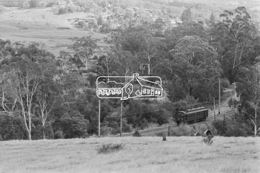
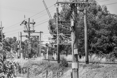
 Eltham District Historical Society Inc
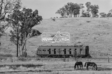
Photograph, George Coop, Single Motor Carriage 471M Tait (Red Rattler) train near Allendale Road level crossing, Eltham, March 1980, 1980
Digital TIFF file Scan of 35mm Kodak Safety 5063 black and white transparency471m, allendale road, eltham, hurstbridge line, level crossing, red rattler, single motor carriage, tait train -
 Eltham District Historical Society Inc
Photograph, George Coop, Single Motor Carriage 471M Tait (Red Rattler) train near Allendale Road level crossing, Eltham, March 1980, 1980
Digital TIFF file Scan of 35mm Kodak Safety 5063 black and white transparency471m, allendale road, eltham, hurstbridge line, level crossing, red rattler, single motor carriage, tait train -
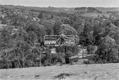
 Eltham District Historical Society Inc
Photograph, George Coop, Hurstbridge bound single carriage Tait (Red Rattler) train near Diamond Street level crossing having just departed Eltham, March 1980, 1980
Digital TIFF file Scan of 35mm Kodak Safety 5063 black and white transparencydiamond street, hurstbridge line, level crossing, red rattler, single motor carriage, tait train -
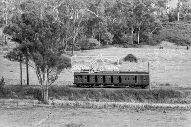
 Eltham District Historical Society Inc
Photograph, George Coop, Hurstbridge bound Single Motor Carriage 471M Tait (Red Rattler) train near the level crossing at Allendale Road, Eltham, March 1980, 1980
Digital TIFF file Scan of 35mm Kodak Safety 5063 black and white transparency471m, allendale road, hurstbridge line, level crossing, red rattler, single motor carriage, tait train -
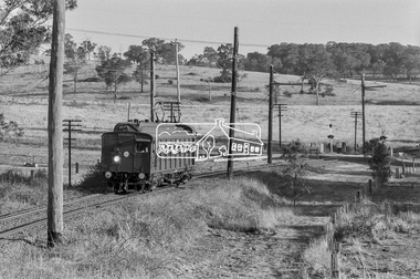
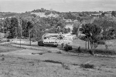
 Eltham District Historical Society Inc
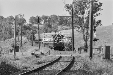
Photograph, George Coop, Eltham bound Single Motor Carriage 471M Tait (Red Rattler) train from Hurstbridge approaches the level crossing at Allendale Road, Eltham, March 1980, 1980
Digital TIFF file Scan of 35mm Kodak Safety 5063 black and white transparency471m, allendale road, hurstbridge line, level crossing, red rattler, single motor carriage, tait train -
 Eltham District Historical Society Inc
Photograph, George Coop, Eltham bound Single Motor Carriage 471M Tait (Red Rattler) train from Hurstbridge approaches the level crossing at Allendale Road, Eltham, March 1980, 1980
Digital TIFF file Scan of 35mm Kodak Safety 5063 black and white transparency471m, allendale road, hurstbridge line, level crossing, red rattler, single motor carriage, tait train -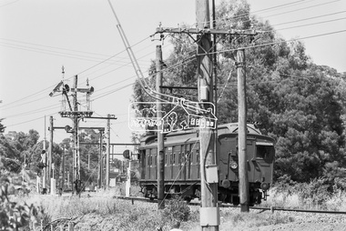
 Eltham District Historical Society Inc
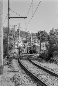
Photograph, George Coop, Looking south across the level crossing at Diamond Street towards Eltham Railway Station, c. December 1980, 1980
A Harris (Blue) train can be seen at Eltham StationDigital TIFF file Scan of 35mm Ilford FP4 black and white transparencydiamond street, eltham railway station, harris (blue) train, level crossing -
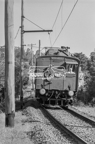
 Eltham District Historical Society Inc
Photograph, George Coop, Single Motor Carriage 471M Tait (Red Rattler) train from Hurstbridge crossing Diamond Street as it approaches Eltham Station, c. December 1980, 1980
Digital TIFF file Scan of 35mm Ilford FP4 black and white transparency471m, eltham railway station, hurstbridge line, red rattler, single motor carriage, tait train -
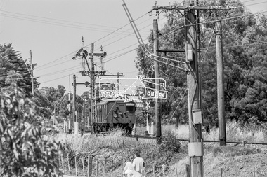 Eltham District Historical Society Inc
Photograph, George Coop, Single Motor Carriage 471M Tait (Red Rattler) train from Hurstbridge crossing Diamond Street as it approaches Eltham Station, c. December 1980, 1980
A Harris (Blue) train can be seen at Eltham StationDigital TIFF file Scan of 35mm Ilford FP4 black and white transparency471m, eltham railway station, hurstbridge line, red rattler, single motor carriage, tait train