Showing 11321 items matching "land-clearing"
-
 Tennis Australia
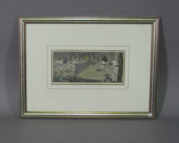
Page from Magazine, Circa 1890
A colour lithographic print from the page of a periodical, featuring four men playing doubles tennis in a clearing within a cemetary. Inscription below: WE FIND A JOLLY PLACE IN THE CEMETARY FOR LAWN-TENNIS. Materials: Paper, Ink, Cardboard, Paint, Glass, Wood, Fibreboard, Adhesive tapetennis -
 Ringwood and District Historical Society
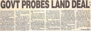
Newspaper, Scrapbook Clipping, Library Collection, Ringwood, Victoria, `
``Newspaper clipping from "The Post" 26-7-95, P 1. GOVT PROBES LAND DEAL The proposed multi-million dollar sale of the Ringwood Bowling Club site to retail giant Coles Myer, is currently being investigated by the State Government. Local Government minister, Roger Hallam, confirmed the Office of Local Government investigation this week.` -
 Bendigo Military Museum
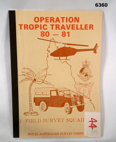
Administrative record - Operation Tropic Traveller 80 - 81 1 Field Survey Squadron, 1981
Project report, Operation Tropic Traveller 1980/81 was mounted to field complete the North Queensland Tac map area during the periods 25 Feb to 11 Nov 1980 and 3 Mar to 13 Oct 1981 Buff colored, A4 Folder, Mosaic in brown of Nth Qld, Helicopter, Corps badges, Land rover.1 field survey squadron, 1 fd svy sqn, royal australian survey corps -
 Phillip Island and District Historical Society Inc.
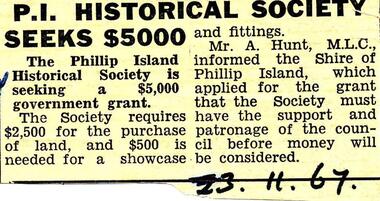
Newspaper clippings, 23/11/1967
Collection of newspaper clippers in scrap book dated 1960 - 1973Newspaper article concerning a financial grant being sought by the Phillip Island Historical Society for land and a showcase."P.I. Historical Society seeks $5,000"local history, newspapers, phillip island historical society seeking grant of $5000, jean jamieson -
 Glenelg Shire Council Cultural Collection
Photograph - Photograph - Henty Beach, Aug-89
Port of Portland Authority ArchivesBack: 'Henty Beach area (Yacht club end) August 89 -
Glenelg Shire Council Cultural Collection
Photograph, Portland Wool Brokers Limited, Wool Store, n.d
Port of Portland AuthorityFront: (no inscriptions) Back: 177 (top left, pencil)port of portland -
Eltham District Historical Society Inc
Photograph, Top of the Devils Bank - Eltham, 1906c
Photograph from land sales brochure c1906 showing scene from top of the Devils Bank Elthamdevils bank, eltham -
 Federation University Historical Collection
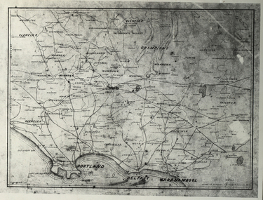
Photograph - Black and White, Map of Western Victoria
WGS 84 37" 47' S 142" 08' EPhotograph of a map showing the Grampians, Glenelg, Portland, Belfast (Port Fairy), Warrnambool, roads and land-holders.western victoria, victoria, belfast, port fairy, warrnambool, manifold -
Glenelg Shire Council Cultural Collection
Photograph - Photograph -Reclamation and Canal work, 1959
Port of Portland Authority ArchivesBack: November 1959 - Top right, black biro. Reclamation and canal work at southern end of botanic gardens - bottom left, pencil.port of portland archives, land reclamation, canal -
Glenelg Shire Council Cultural Collection
Photograph - Photograph - land reclamation, 1959
Port of Portland Authority ArchivesFront: Canal and Reclamation. Aerial view west November 1959 - typed.port of portland archives, land reclamation, canal, botanic gardens -
 Running Rabbits Military Museum operated by the Upwey Belgrave RSL Sub Branch
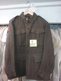
Tunic
TUNIC khaki army Wool with colour patches (RAA 1 Aust. Corps, Land H Q.)uniform, 1949, army -
 Bendigo Historical Society Inc.
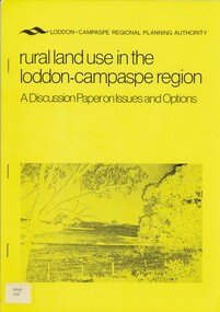
Book - RURAL LAND USE IN THE LODDON-CAMPASPE REGION, 1976
RURAL LAND USE IN THE LODDON-CAMPASPE REGION - a discussion paper on issues and options. 30 pages, with maps.Loddon-Campaspe regional planning authoritybook, rural, land use, loddon campaspe, rural, land use, agriculture -
 Bendigo Historical Society Inc.
Document - TED BEATTIE COLLECTION: INFORMATION SHEET, Pre 1980s
Information sheet 'Bendigo - where to go and what to see gold centre victoria - land of the welcome stranger' -
 Bendigo Historical Society Inc.
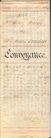
Document - JOHANSON COLLECTION: MORTGAGE MRS CATHERINE STUART RICHARDS
Conveyance of land from Mr Henry Smith to Mr. James Penistan. Dated 22 April 1864.bendigo, land sales, mr. henry smith to mr. james penistan, henry smith, james penistan. -
 Bendigo Historical Society Inc.
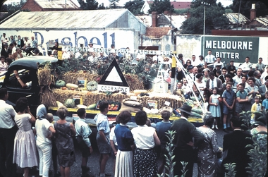
Slide - BENDIGO EASTER PROCESSION, Apr 1961
Slide.BENDIGO EASTER PROCESSION. Goornong Senior Young Farmers Club float depicting produce grown on the land.slide, bendigo, bendigo easter procession, bendigo easter procession -
 Dutch Australian Heritage Centre Victoria
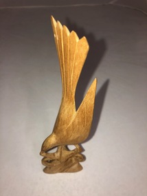
Wooden Bird Carving
Small pale wooden carving of a bird about to land on a tree branch which forms the carving's base. -
 Uniting Church Archives - Synod of Victoria
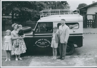
Photograph, Thomas Verrier & family, 1962
Thomas Verrier (ordained 1961): Sprent (Tas.) (HM) 1956–60; Katherine (NT) 1962–65; Nightcliff (Darwin) 1966–67; Bendigo North 1968–71; Burnie (Tas.) 1971–76; Bayswater & Wantirna 1977–?.Thomas Verrier and family standing alongside the Land Rover ready to depart for Uranium Fields Patrol Katherine.Rev. Thomas Verrier and family before departure for Katherine.verrier, thomas -
Whitehorse Historical Society Inc.
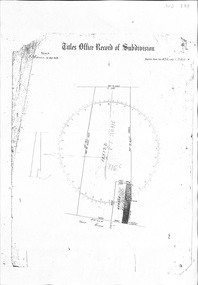
Document, Certificate of title, 28/02/1924 12:00:00 AM
Certificate of Title for c. 3 acres of land east of Mitcham Road owned by Mary Theresa KirkpatrickCertificate of Title for c. 3 acres of land east of Mitcham Road owned by Mary Theresa KirkpatrickCertificate of Title for c. 3 acres of land east of Mitcham Road owned by Mary Theresa Kirkpatrickmitcham road, mitcham -
 Whitehorse Historical Society Inc.
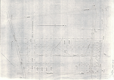
Document, Map of Vermont & Mitcham
Copy of map showing land in Mitcham and Vermont areasCopy of map showing land in Mitcham and Vermont areas bounded by Whitehorse , Mitcham, Canterbury and Heatherdale roads.Copy of map showing land in Mitcham and Vermont areasland subdivision, whitehorse road, mitcham, heatherdale road, canterbury road, vermont, mitcham road -
 Whitehorse Historical Society Inc.
Document, Crown Allotment
Land documents relating to Crown Allotment 116 Shady Grove Nunawading Parish of Nunawading County of BourkeLand documents relating to Crown Allotment 116 Shady Grove Nunawading Parish of Nunawading County of BourkeLand documents relating to Crown Allotment 116 Shady Grove Nunawading Parish of Nunawading County of Bourkeland titles, holmes, dave, shady grove nunawading no.76, helen, jobbins, thomas, the freehold investment and banking company of australia ltd, wilson, david duncan butchart, boyle, walter, holbery, emily rachel, fisher, james cowley morgan -
 Whitehorse Historical Society Inc.
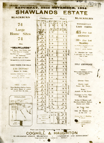
Document, Shawlands Estate, 22/11/1924 12:00:00 AM
Notice of Sale of land Holland Road and Canterbury RoadNotice of Sale of land Holland Road and Canterbury Road Blackburn Original in Haughton Maps LaTrobe LibraryNotice of Sale of land Holland Road and Canterbury Road land subdivision, canterbury road, blackburn south, holland road, shawlands avenue, coghill & haughton, shawlands estate, haughton map collection, state library of victoria. latrobe library -
Whitehorse Historical Society Inc.
Document, Healesville Freeway Reservation, 2013
Renewal project encompassing three land use concepts.Renewal project encompassing three land use concepts: Shared pathway, Davy Lane and Community use.Renewal project encompassing three land use concepts.healesville freeway reservation, vicroads -
Whitehorse Historical Society Inc.
Article, Blackburn North, 2013
Real estate advertisement for former orchard block of land in Blackburn North.Real estate advertisement for former orchard block of land in Blackburn North. Agent: Woodards. Aerial photo.Real estate advertisement for former orchard block of land in Blackburn North. surrey road blackburn north, no. 59-67, cock, herbert, junction road blackburn north -
Whitehorse Historical Society Inc.
Photograph - Illustration, Stephen Creek, n.d
Photo of Stephen Creek,1836 - 1908, early land holder who arrived in box Hill in 1856.Photo of Stephen Creek,1836 - 1908, early land holder who arrived in box Hill in 1856.Photo of Stephen Creek,1836 - 1908, early land holder who arrived in box Hill in 1856.creek, stephen, pioneers -
Whitehorse Historical Society Inc.
Newspaper - Article, Residents fear for streetscape, 28/09/1994
'Residents fear for streetscape' ' Mitcham Mansion,' (Walker home), Meerut Street, Mitcham, land subdivision opposite.meerut street, mitcham, walker, edgar edwardes, australian tesselated tile co pty ltd, barelli, ken, land subdivision -
 Whitehorse Historical Society Inc.
Article, Bid To Relieve Housing Pressure, 2018
On 1 Jan 2018, the Vacant Residential Land Tax will be applied to properties vacant for six months or more.housing, city of whitehorse -
 Whitehorse Historical Society Inc.
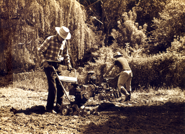
Photograph, Archibald McArthur`
Archibold McArthur originally owned 6 acres and produced flowers which were sold at the Victoria Market, and vegetables which were sold at a roadside stall outside his property in Canterbury Road , Forest Hill.Eastside Plants established a plant nursery as p[art of the property in 1979 and later added 'Archies Cafe' in 1987. In 2007 the nursery closed its doors and in 2008 units were built on the property.Sepia photo of Archibald McArthur and one other tilling land on his property in Canterbury Forest Hillmcarthur archibald, forest hill, plant nurseries, eastside plants, archies cafe -
 Beechworth Honey Archive
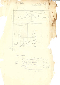
Hand-Drawn Diagram of Land by Frank Lebbell Frost September 1920
Hand-drawn diagram of land at Dookie by Frank L. Frost. Depicts plan od three allotments.hand drawn, hand-drawn, plan, land, dookie, frost, beekeeper, beechworth honey -
Lakes Entrance Historical Society
Book, Delbridge Graham R, Freeman Anne, The Church of St Peters by the Lakes, 1976
History of St Peters by the Lakes Paynesville Victoria, acquisition of land, building plans, forward by Bishop Delbridgereligion -
Stawell Historical Society Inc
Photograph - Aerial Photograph, Norwellan / AUNDE
Textile Mill infrastructure when Norwellan North Western Woolen Mills became Norwellan Textiles then AUNDEEarly Colour Aerial Photograph showing complete land and infrastructure. Plastic frame imitating brown marble.industry