Showing 3220 items
matching road map
-
 Whitehorse Historical Society Inc.
Map, Sketch map, 1932
... Whitehorse Historical Society Inc. 2-10 Deep Creek Road ...Sketch map of Doncaster, Mitcham and Tunstall. Scale 1 inch = 40 chains. 4th issue. 19 Apr 32Sketch map of Doncaster, Mitcham and Tunstall. Scale 1 inch = 40 chains. 4th issue. 19 Apr 32Sketch map of Doncaster, Mitcham and Tunstall. Scale 1 inch = 40 chains. 4th issue. 19 Apr 32maps, doncaster, mitcham, tunstall, nunawading -
Whitehorse Historical Society Inc.
Map, Legislative Council - Electoral Provinces, 1991
State of Victoria. Legislative Council Electoral Provinces. Sheet 3 Metropolitan Map. 1990 - 1991 redivision.State of Victoria. Legislative Council Electoral Provinces. Sheet 3 Metropolitan Map. 1990 - 1991 redivision.State of Victoria. Legislative Council Electoral Provinces. Sheet 3 Metropolitan Map. 1990 - 1991 redivision.electoral boundaries, victoria. parliament. legislative council -
Whitehorse Historical Society Inc.
Map, State Electoral Districts, 1978
State Electoral Districts [Melbourne] 1975. Redivision (1977 subdivisions0. Scale 1: 90,000State Electoral Districts [Melbourne] 1975. Redivision (1977 subdivisions0. Scale 1: 90,000State Electoral Districts [Melbourne] 1975. Redivision (1977 subdivisions0. Scale 1: 90,000electoral boundaries, victoria. parliament. legislative assembly -
Whitehorse Historical Society Inc.
Map, State Electoral Provinces, 1978
State Electoral Provinces 1975 redivision (1977 subdivisions) Scale 1:90,0000State Electoral Provinces 1975 redivision (1977 subdivisions) Scale 1:90,0000State Electoral Provinces 1975 redivision (1977 subdivisions) Scale 1:90,0000victoria. parliament. legislative council, electoral boundaries -
Whitehorse Historical Society Inc.
Map, Legislative Assembly, 1984
State of Victoria Legislative Assembly electoral districts 1983 - 1984 redivision (Melbourne Metropolitan area) Scale 1:50,000State of Victoria Legislative Assembly electoral districts 1983 - 1984 redivision (Melbourne Metropolitan area) Scale 1:50,000State of Victoria Legislative Assembly electoral districts 1983 - 1984 redivision (Melbourne Metropolitan area) Scale 1:50,000victoria. parliament. legislative assembly, electoral boundaries -
Whitehorse Historical Society Inc.
Map, Subdivision Plan for part of Blackburn Park, c1910
Photocopy of advertisement for sale of subdivision of area in BlackburnPhotocopy of advertisement for sale of subdivision of area in Blackburn between the railway line and Whitehorse Road between Station Street and Alfred Street. Some purchasers noted between 1903 - 1912.Photocopy of advertisement for sale of subdivision of area in Blackburnland subdivision, whitehorse road, blackburn, station street, blackburn, railway road, blackburn, queen street, blackburn, albert street, blackburn, chapel street, blackburn, george street, blackburn, cottage street, blackburn, alfred street, blackburn -
 Whitehorse Historical Society Inc.
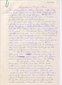
Map, Schwerkolt property and rough plan of old stone house, 1993
Map drawn by Arthur SchwerkoltMap drawn by Arthur Schwerkolt in 1993 from memory assisted by survey map of 1902. Covering letter from Glyn France [also at ND1367 (G-H-S-C 46) gives extra details.Map drawn by Arthur Schwerkoltschwerkolt cottage, schwerkolt, arthur, whalen, rosalie, france, glyn -
Whitehorse Historical Society Inc.
Map, Parkmore Nunawading, c1958
Subdivision plan of Parkmore Estate, Forest Hill using lot numbers.Subdivision plan of Parkmore Estate, Forest Hill using lot numbers. Advertised as a 'complete' community development by Southern Construction Company.Subdivision plan of Parkmore Estate, Forest Hill using lot numbers. parkmore estate, forest hill, parkmore road, forest hill, ranfurlie road, forest hill, quentin street, forest hill, oberon street, forest hill, cherryl street, forest hill, deauville street, forest hill, everglade avenue, forest hill, inglewood avenue, forest hill, cedar court, forest hill, martin court, forest hill, wandin court, forest hill, ranfurlie court, forest hill, hampshire road, forest hill, vanbrook street, forest hill, husband road, forest hill, ashmore road, forest hill, brentford square shopping centre, forest hill, sherman street, forest hill, sylvan court, forest hill, briarfield court, forest hill, yardley court, forest hill, wingrove street, forest hill, jolimont road, forest hill, wembley court, forest hill, longbrae avenue, forest hill, longbrae court, forest hill, teal court, forest hill, marleigh street, vermont, unley court, vermont, irving court, vermont, irving court, vermont, lexington street, vermont, ferncroft street, vermont, southern construction company -
Whitehorse Historical Society Inc.
Map, Nunawading Planning Scheme. Local Section, 1993
Map of City of Nunawading.Map of City of Nunawading showing zoning of areas by means of colours and some detailed designations. Note: ' This map contains amendments as at 14 Oct 1993'Map of City of Nunawading.city of nunawading, maps, land use -
Whitehorse Historical Society Inc.
Map, Proposed shared path network, 2001
Draft plans of proposed shared path networkDraft plans of proposed shared path network for Eastern Freeway Extension, Springvale Road to Ringwood.Draft plans of proposed shared path network plans, eastern freeway extension, city of whitehorse, vicroads, city of maroondah, vicroads bicycle coordinator, footpaths, bicycle paths -
 Whitehorse Historical Society Inc.
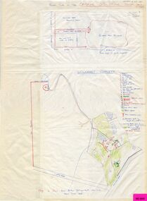
Document - Hand Written Note, Blackburn Cool Store, 2001
Map drawn by Arthur Schwerkolt in 1993 from memory assisted by survey map of 1902.Manuscript account of the history and operation of the Blackburn Cool Store and the Blue Moon Fruit Cooperative, by Ron Pearce.Map drawn by Arthur Schwerkolt in 1993 from memory assisted by survey map of 1902.blackburn cool store, blue moon fruit co-operative ltd., southern victoria pear packing company limited -
Whitehorse Historical Society Inc.
Map, Springfield Road, Blackburn, 1924
... by Ron Pearce. Springfield Road, Blackburn Map Map ...Plan of subdivision, parts of Crown Portions 73 and 74, parish of Nunawading, County of Bourke.Plan of subdivision, parts of Crown Portions 73 and 74, parish of Nunawading, County of Bourke. Passed by MMBW 24 May 1924. Subdivision not implemented. Originally owned by Leonard Sherwin Bayley, then by Edward Henry Pearce, then by Ron Pearce. Part compulsorily acquired as site for Blackburn High School. With historical notes by Ron Pearce.Plan of subdivision, parts of Crown Portions 73 and 74, parish of Nunawading, County of Bourke. bayley, leonard sherwin, pearce, edward h, pearce, ronald harry, orchards, blackburn high school, north blackburn square shopping centre -
Whitehorse Historical Society Inc.
Map, Council facilities, c1992
Map of City of Nunawading with parks and facilities marked and indexed.Map of City of Nunawading with parks and facilities marked and indexed.Map of City of Nunawading with parks and facilities marked and indexed.recreation facilities, city of nunawading, maternal and child health centres, senior citizens centres, parks and reserves, libraries, child care -
 Whitehorse Historical Society Inc.
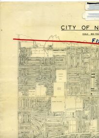
Legal record - Map, F19 freeway, 1/12/1977 12:00:00 AM
Approximate alignments of F19(Eastern) Freeway, F9 and Scoresby Freeway, marked on 1973 edition of City of Nunawading map,Approximate alignments of F19(Eastern) Freeway, F9 and Scoresby Freeway, marked on 1973 edition of City of Nunawading map, Scale 800 ft = 1 inch.Approximate alignments of F19(Eastern) Freeway, F9 and Scoresby Freeway, marked on 1973 edition of City of Nunawading map, freeways, city of nunawading, eastern freeway, scoresby freeway -
Whitehorse Historical Society Inc.
Map, Community facilities, 1/10/1981 12:00:00 AM
Map of the City of Nunawading showing community facilitiesMap of the City of Nunawading showing community facilitiesMap of the City of Nunawading showing community facilitiesparks and reserves, city of nunawading, schools, senior citizens centres, maternal and child health centres, post offices, police stations, preschools -
Whitehorse Historical Society Inc.
Map, Parks and recreation facilities, 1/06/1995 12:00:00 AM
Map of the City of Whitehorse with parks and reserves marked and indexedMap of the City of Whitehorse with parks and reserves marked and indexed.Map of the City of Whitehorse with parks and reserves marked and indexedcity of whitehorse, parks and reserves, bicycle paths, recreation facilities, blackburn, blackburn north, blackburn south, burwood east, forest hill, mitcham, nunawading, vermont, vermont south -
Whitehorse Historical Society Inc.
Map, Waverley, c1985
Map of Waverley, including Box Hill Soiuth, Blackburn South, Vermont, Vermont South, Burwood East, Burwood, Ashburton, Mount Waverley, Glen Waverley, Oakleigh South, Clayton North and Mulgrave.Map of Waverley, including Box Hill Soiuth, Blackburn South, Vermont, Vermont South, Burwood East, Burwood, Ashburton, Mount Waverley, Glen Waverley, Oakleigh South, Clayton North and Mulgrave. UBD map issued by Nicholls Gledhill Real Estate Agents. Scale 1:50,000.Map of Waverley, including Box Hill Soiuth, Blackburn South, Vermont, Vermont South, Burwood East, Burwood, Ashburton, Mount Waverley, Glen Waverley, Oakleigh South, Clayton North and Mulgrave. blackburn south, burwood east, vermont, vermont south, forest hill -
Whitehorse Historical Society Inc.
Map, City of Whitehorse, 1/03/1995 12:00:00 AM
... by Richard Meloni showing roads, railways, creeks. Map of City ...Map of City of Whitehorse prepared by Richard Meloni showing roads, railways, creeks.Map of City of Whitehorse prepared by Richard Meloni showing roads, railways, creeks.Map of City of Whitehorse prepared by Richard Meloni showing roads, railways, creeks.blackburn, nunawading, blackburn south, mitcham, vermont, vermont south, blackburn north, forest hill, burwood east, city of whitehorse -
Whitehorse Historical Society Inc.
Map, City of Nunawading, c1975
Map of City of Nunawading, showing location of 186 parks and reserves.Map of City of Nunawading, showing location of 186 parks and reserves. Scale 1:10,000 with list of streets and their map coordinates.Map of City of Nunawading, showing location of 186 parks and reserves. city of nunawading, parks and reserves -
Whitehorse Historical Society Inc.
Map, Heritage overlay map, 1/02/1999 12:00:00 AM
City of Whitehorse heritage review : Heritage overlay map.City of Whitehorse heritage review : Heritage overlay map.City of Whitehorse heritage review : Heritage overlay map.city of whitehorse, historic buildings, blackburn, blackburn south, blackburn north, mitcham, nunawading, forest hill, vermont, vermont south, burwood east -
Whitehorse Historical Society Inc.
Map, Shire of Blackburn and Mitcham, 1938
Plan of Shire of Blackburn and Mitcham showing sections and lot numbers. Scale 8 chains to 1 inch.Plan of Shire of Blackburn and Mitcham showing sections and lot numbers. Scale 8 chains to 1 inch.Plan of Shire of Blackburn and Mitcham showing sections and lot numbers. Scale 8 chains to 1 inch.shire of blackburn and mitcham, blackburn, blackburn north, blackburn south, burwood east, forest hill, mitcham, nunawading, vermont, vermont south -
Whitehorse Historical Society Inc.
Map, Shire of Blackburn and Mitcham, c1935
Map of Shire of Blackburn and Mitcham showing refuse collection days, sections and lot numbers. Scale 8 chains to 1 inch.Map of Shire of Blackburn and Mitcham showing refuse collection days, sections and lot numbers. Scale 8 chains to 1 inch.Map of Shire of Blackburn and Mitcham showing refuse collection days, sections and lot numbers. Scale 8 chains to 1 inch.shire of blackburn and mitcham, blackburn, blackburn north, blackburn south, burwood east, forest hill, mitcham, nunawading, vermont, vermont south -
Whitehorse Historical Society Inc.
Map, Aerial maps, 2/04/1966 12:00:00 AM
Melbourne 1966 project, runs 10A and 11A, lens 122 151.75 mm 9,800. Photo nos 77, 107, 109, 161, 163, 165.Melbourne 1966 project, runs 10A and 11A, lens 122 151.75 mm 9,800. Photo nos 77, 107, 109, 161, 163, 165. Areas and boundaries: Map no 77 W. Park and Cook Roads; E. Dubon Rd; N Oban Rd; S Reilly St. Map No 107. W. Indra Rd and Pakenham St; E. Rooks Rd & McLares Rd; N. Maroondah Hwy; S. Hawthorn Rd & Eley Rd. Map No 109 W. Elgar Rd. E. Blackburn Rd & McKean St; S. Eley Rd & Burwood Hwy. Map No 161. W. Elgar Rd & Huntingdale Rd; E. Blackburn Rd; N. Burwood Hwy; S. Waverley Rd. Map No 163. W. Blackburn Rd; S. Springvale Rd; N. Eley Rd & Hawthorn Rd; S. Glen Waverley Railway Line. Map No 165. W. Stanley Rd, Vermont South; E. Cathies Lane, Wantirna South; N. North of Burwood Hwy; S. High Street. Melbourne 1966 project, runs 10A and 11A, lens 122 151.75 mm 9,800. Photo nos 77, 107, 109, 161, 163, 165. aerial photographs, blackburn, blackburn south, forest hill, nunawading, box hill, burwood, burwood east, donvale, mount waverley, glen waverley, wantirna, vermont south, mitcham, ringwood north, ringwood -
Whitehorse Historical Society Inc.
Map, City of Nunawading, 1/02/1973 12:00:00 AM
Map of City of Nunawading shoeing open creeks or watercourses and watercourses that have been piped.Map of City of Nunawading shoeing open creeks or watercourses and watercourses that have been piped. Scale: 800 feet =1 inchMap of City of Nunawading shoeing open creeks or watercourses and watercourses that have been piped. blackburn, blackburn north, blackburn south, burwood east, forest hill, mitcham, nunawading, vermont, vermont south, city of nunawading, creeks -
Whitehorse Historical Society Inc.
Map, Shire of Blackburn and Mitcham, 10/10/1939 update
Map of Shire of Blackburn and Mitcham showing Departmental ball hydrants and departmental pillar ball hydrants.Map of Shire of Blackburn and Mitcham showing Departmental ball hydrants and departmental pillar ball hydrants. Scale 8 chains to 1 inch.Map of Shire of Blackburn and Mitcham showing Departmental ball hydrants and departmental pillar ball hydrants.shire of blackburn and mitcham, fire hydrants, blackburn, blackburn north, blackburn south, burwood east, forest hill, mitcham, nunawading, vermont, vermont south -
Whitehorse Historical Society Inc.
Map, Melbourne and suburbs, 1923
Section of map 'Melbourne and Suburbs' compiled at the Department of Lands and Survey, Melbourne by E. S. Hilcke, March 1923, reprinted 1940.Section of map 'Melbourne and Suburbs' compiled at the Department of Lands and Survey, Melbourne by E. S. Hilcke, March 1923, reprinted 1940. Scale 40 chains: 1 inch. - Shire of Blackburn and MitchamSection of map 'Melbourne and Suburbs' compiled at the Department of Lands and Survey, Melbourne by E. S. Hilcke, March 1923, reprinted 1940.department of lands and surve, melbourne and suburbs -
 Whitehorse Historical Society Inc.
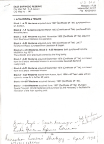
Letter - Correspondence, East Burwood Reserve, 1993
Various documents relating to the establishment of East Burwood ReserveVarious documents relating to the establishment of East Burwood Reserve including acquisition of land, details, plans, locality map, news cuttings and photographs. Appears to be copy of Nunawading City Council File April 1993Various documents relating to the establishment of East Burwood Reserve sportsgrounds, east burwood reserve, soilleur (dr), hitchens, anna, blue moon fruit co-operative ltd., jacobson and logan, king family, central methodist mission, aussat, tally ho, sewart, bill -
 Whitehorse Historical Society Inc.
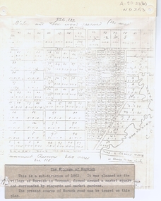
Document, The Village of Norwich, C1862
Map showing the planned village of NorwichMap showing the planned village of Norwich in Vermont about 1862Map showing the planned village of Norwichland settlement, morack road, vermont south, barkly street, vermont, george street, william street -
Whitehorse Historical Society Inc.
Pamphlet - Advertising brochure, Kenmare Heights Estate, 1927
Clearing sale by public auction , Saturday 26/11/1927 of Kenmare Heights Estate Mont Albert, Situated between Belmore Road, Boundary Road, Strabane Avenue, Union Road and Dunloe Avenue. Advertising material and mapknight & harwood auctioneer, auctions, kenmare height estate, union road mont albert, belmore road, relowe crescent, whitehorse road, evalina street, francesca street, mozelle street, dunloe avenue -
Whitehorse Historical Society Inc.
Pamphlet, Go bush in Nunawading, 1986
A leaflet with names, locations and map of bushland parks in Nunawading.A leaflet with names, locations and map of bushland parks in Nunawading.A leaflet with names, locations and map of bushland parks in Nunawading.city of nunawading. parks and recreation department., parks and reserves