Showing 171476 items
matching will street
-
 Clunes Museum
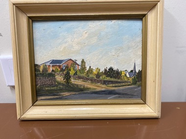
Painting, Unknown
Marny Fenton was the first president of the Clunes MuseumMarny Fenton was the first president of the Clunes MuseumOil painting of house on corner of Service Street and Alliance Street, Clunes, Victoria, AustraliaSigned by M. Fentonartist, painting, fenton -
 Tatura Irrigation & Wartime Camps Museum
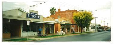
Photograph, Douglas Quality Butchers Hogan Street Tatura
Shows picture of Douglas Quality Butcher, Hogan Street, Tatura. Also Bank of New South Wales and National Bank.Colour photograph showing Douglas Quality Butcher in Hogan Street, Tatura and other businesses to the right of the butchers including the Bank of New South Wales and National Bank. Photograph stuck onto piece of white cardboard. hogan street tatura, douglas butchers tatura, bank of new south wales tatura, national bank tatura -
 Port Melbourne Historical & Preservation Society
Photograph - Wedding procession Maree Menzel & Marcus Davidson, Station Street to Yacht Club, Pat Grainger, 1989
Maree and Marcus of 63 Station Street married after several years of living together. As she is a fashion designer, she designed and made all costumes; as he is a musician, some of his friends played jazz and rock for the procession to the Port Melbourne Yacht Club for the ceremony. Only three neighbours (including photographer) were invited to accompany the procession. The wedding must have been one of the last functions in the clubhouse before it burned.From a group of photographs of the 1989 wedding procession of Maree Menzel and Marcus Davidson, from the railway reserve near 63 Station Street to the Port Melbourne Yacht Club:Marcus and the dunny at 63 Station Street, showing his vest with hand embroidered graffiti motifs as often painted by him on local surfaces.celebrations fetes and exhibitions, built environment, maree menzel, marcus davidson -
 City of Kingston
Pamphlet - Colour, R. Malcolm Estate Agents et al, Last Chance Land Sale Heritage Estate Cheltenham, c.1994
Sales plan for land in the suburb of Cheltenham, bounded by Chesterville Road and Bernard Street, and incorporating Clendon Court, Tintern Grove and Tintern MewsThis land sale pamphlet illustrates one of the last subdivisions of the century in Cheltenham, incorporating house and land packages. It shows that land sales and subdivision for the area had slowed considerably by the end of the 1900s and that the infrastructure was significantly developed. Colour pamphlet advertising last chance land sale of Heritage Estate Cheltenham. Incorporates a map of the estate bordered by Chesterville Road and Bernard Street, and including Clenton Court, Tintern Grove and Tintern Mews.cheltenham, land sales, estate -
 Flagstaff Hill Maritime Museum and Village
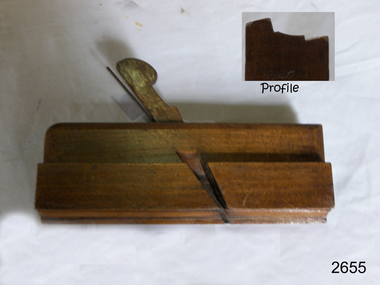
Tool - Moulding wood Plane, Mid to Late 19th Century
A moulding plane is a specialised plane used for making the complex shapes found in wooden mouldings that are used to decorate furniture or other wooden objects. Traditionally, moulding planes were blocks of wear-resistant hardwood, often beech or maple, which were worked to the shape of the intended moulding. The blade or iron was likewise formed to the intended moulding profile and secured in the body of the plane with a wooden wedge. A traditional cabinetmakers shop might have many, perhaps hundreds, of moulding planes for the full range of work to be performed. Large crown mouldings required planes of six or more inches in width, which demanded great strength to push and often had additional peg handles on the sides, allowing the craftsman's apprentice or other workers to pull the plane ahead of the master who guided it. John Moseley & Son: Records indicate that before 1834, the firm is listed at number 16 New Street, London and according to an 1862 advertisement the shop had been established in New Street since 1730, The Sun insurance records from the time show that John Moseley was the possessor of a horse mill in the yard of his premises, which means that some kind of manufacturing was taking place, as the mill would have provided power to run a saw or perhaps a grinding wheel so the probability is that he did not just sell tools, he made them as well. John Moseley died in 1828 and his will he names his four sons: John, Thomas, William and Richard. To complicate matters he also had brothers with the same first names; brothers Richard (of Piccadilly) and William (of Peckham Rye) are named as two of the executors. Brother Thomas is not mentioned in this will, but became a minister and was one of the executors of brother Richard’s estate when he died in 1856. From John’s will, we also learn that, although the shop was in New Street, he resided in Lympstone, Devon. The family must have had a house in that county for quite some time as both sons Richard and William are baptised in Devon, although John and Thomas were baptised in London. In the 1841 and 1851 census records, we just find William in New Street, but in 1861 both William and Richard are listed there as toolmakers. That Richard was staying overnight at New Street was probably just accidental as in 1851 and 1871, we find him with his wife Jane and children in Clapham and Lambeth respectively. In 1851 Richard is listed as “assistant clerk cutlery warehouse” and in 1871 as “retired plane maker and cutler”. Although the actual place of work is not stated, one may assume he worked in the family business. 1862 is a year full of changes for the firm. In that year, William had a new property built at 27 Bedford Street. In the catalogue for the 1862 International Exhibition, 54 Broad Street (later 54-55 Broad Street) is listed for the first time, which may very well coincide with the split of the business into a retail and a wholesale branch. Around the same time, they must have moved from New Street to 17 & 18 King Street because their manufacturing premises had been pulled down to form the New Street from Cranbourne Street to King Street. In January 1865, William died and Richard continued the business. In 1867, the partnership he had with his son Walker and Thomas Elis Hooker, is dissolved. Richard continued tool making at King Street and Bedford Street. Richard retired somewhere between 1867 and 1871, but the business continued. The business is taken over by W M Marples & Sons and tools continued to be made in London until 1904 when manufacturing relocated to Sheffield. A vintage tool made by a well documented company, this item was made commercially for firms and individuals that worked in wood and needed a tool that could produce a ornamental finish to timber. The tool was used before routers and spindle moulders came into use after World War ll, a time when to produce a decorative moulding for a piece of furniture, door trims etc or other items had to be accomplished using hand tools and in particular one of these types of planes. These profiled planes came in various shapes and sizes to achieve a decorative finish. A significant tool from the mid to late 19th century that today is quite rare and sought after by collectors. It gives us a snapshot of how furniture and other decorative finishes were created on timber by the use of hand tools. Tools that were themselves hand made shows the craftsmanship used during this time not only to make a tool such as the subject item but also the craftsmanship needed to produce a decorative finish that was needed to be made for any timber item. Side Bead Single Box moulding plane J Moseley & Sons maker also stamped Healy 188 High Street Poplar Surrey (retailers) marked (owners A Bowen & J W Gower Size 9/16"flagstaff hill, warrnambool, shipwrecked-coast, flagstaff-hill, flagstaff-hill-maritime-museum, maritime-museum, shipwreck-coast, flagstaff-hill-maritime-village, plane moulding, moulding plane, plane, j heath, moseley -
 Kew Historical Society Inc
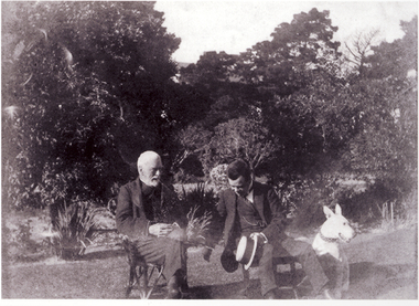
Photograph - Henry and Bruce Hedderwick, c.1913
Bruce P. Hedderwick was the son of the Kew lawyer and politician Henry Hedderwick and lived with his family at 'Garoopna' on the corner of A'Beckett and Barry Streets, Kew. This photograph is part of a larger donation of items relating to the Hedderwick family of Kew.Black and white print copy of the elderly Henry Hedderwick and his son Bruce Hedderwick in the garden of 'Garoopna' in A'Beckett Street, Kew. The dog beside Bruce was named 'Danny'henry hedderwick, garoopna -- a'beckett street, historic houses -- kew (vic.), bruce hedderwick -
 Mt Dandenong & District Historical Society Inc.
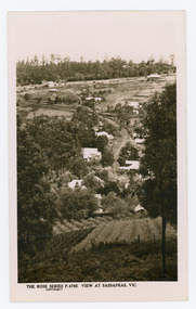
Photograph, View at Sassafras, Vic, c1930
View down the Main Street of Sassafras looking south with the Mechanics Institute in the centre of the picture. The raspberry patch in the foreground belonged to Woniger Hansen who built Mountain Rest (Rostrevor). The land was subdivided after his death in 1923. The raspberry patch is in the area of the current Mason Grove.Black and white Rose Series postcard P. 4765 looking south down the Main Street of Sassafras with buildings either side and berry patches in the foreground.On reverse POST CARD. THE "ROSE' SERIES DELUXE. A REAL PHOTOGRAPH PRODUCED IN AUSTRALIA. PUBLISHED BY 'THE ROSE STENOGRAPHS" Armadale. Victoria sassafras, rose series, rostrevor, woniger hansen, hansen, mechanics' institute, raspberry, raspberry crop, mountain rest, mason grove -
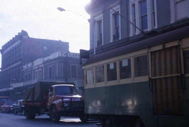
 Melbourne Tram Museum
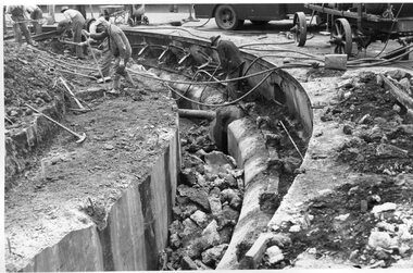
Photograph - Black and White - demolishing cable tram track Smith and Gertrude Streets 1954/55
The photograph shows the demolition or removal of the cable tram track at the intersection of Smith Street and Gertrude St Fitzroy, 1954/55. Photo shows the workmen excavating and demolishing parts of the massive infrastructure needed at this curve to enable cable trams to pass around the sharp curve, still one of the sharpest on today's Melbourne tram system. The outside cable tram track remains in position. The MMBW plan shows a large cable sheave pit on the outside of the curve. The 1955 Annual Report notes that work commenced following the completion of the Queen's visit in March 1954 and that all work was done by day-labour. The track was opened to service in late June 1955. Photographer is possibly Keith Kings.Yields information about the extent of work need to convert the former Northcote Cable tram route to Electric trams, the people, the extent of the original construction and the methods used to undertake the work.Photograph - Black and White - demolishing cable tram track Smith and Gertrude Streets 1954/55trams, tramways, cable trams, workmen, mmtb, demolition, track work, conversion, smith street, gertrude street, fitzroy -
 Warrnambool and District Historical Society Inc.
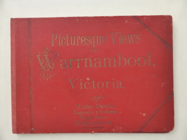
Book - Picturesque views of Warrnambool, Picturesque Views of Warrnambool, 1894
This album has been produced in Germany at the end of the 19th century for the Warrnambool tourist market. It was sold in the book shop of Walter Davies. The father of Walter Davies, also called Walter, was a law clerk and accountant who established the book and stationery shop in Timor Street in the late 1860s. The business was operated by Walter Davies Senior, then his son and later the grandsonThis album is of interest for several reasons:- 1. It is an interesting example of the type of tourist souvenir available to visitors to Warrnambool in the late 19th century. 2. It contains 13 photographs of Warrnambool in the late 19th century and these are of considerable historical value. 3. It is a good example of the type of articles sold by Walter Davies at his Timor Street shop in 1894. This is a hard cover folder containing 13 black and white photographs of Warrnambool and surrounds. The photographs are on several sheets of white paper joined together in concertina fashion to fit into the folder but they have become detached from the folder. Some of the photographs are torn at the edges. The cover of the folder has embossed gold lettering and the narrow spine is faded and the front cover is a little torn and stained. The inscription. ‘Xmas 1894’ is handwritten in black ink. ‘Picturesque Views of Warrnambool Victoria’ ‘Walter Davies, Bookseller & Stationer, Timor Street, Warrnambool’ ‘Printed in Germany’ ‘Xmas 1894’ picturesque warrnambool,, picturesque views of warrnambool, walter davies -
 Port Melbourne Historical & Preservation Society
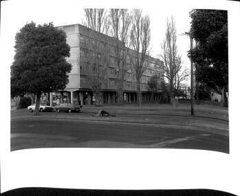
Photograph - Raglan Street Housing Commission Flats viewed from Crockford Street, Andrew U'REN, C. 1970s - 1980s
From a box of photographs in Nancy U'REN's papers used during research for her thesis, The Early Growth and Development of Sandridge (1976) and/or her book with Noel TURNBULL, A History of Port Melbourne (1983). The print was probably made by her son, Andrew U'REN, and he may have also taken the photograph. The photograph includes two people on the median strip. It is unclear what they are doing or what has happened just before the photograph was taken. One person is kneeling closely over the other who appears to be lying on their back.Black and white photograph of the Raglan Street Housing Commission flats at the corner of Ingles and Crockford Streets viewed from Crockford Street. Large white border at the bottom.Details of photographic paper type and exposure details in blue ink on the reverse.built environment - public housing, ingles street, crockford street, raglan street housing commission of victoria flats, built environment - domestic, nancy u'ren nee morris -
 Robin Boyd Foundation
Slide, Robin Boyd, 1967
Colour slide in a mount. Street Scene, Chapel Street. Prahran, Vctoria, Australia. Sydney Hall opened Hall's book store at 262 Chapel Street in 1920.Made in Australia / 10 / JUN 67M6 / Encircled 6 (Handwritten)melbourne, slide -
 Hume City Civic Collection
Photograph, Mid 1990's
The building suppliers and the Sunbury CFA were sited at the northern end of Evans Street and in the past were away from the main shopping centre. As Sunbury expanded and Sunbury Shopping Square was built on the opposite side of Evans Street, the building suppliers closed down and the CFA depot was moved out of the town centre to two other locations to avoid traffic conjestion.A coloured photograph of the east side of Evans Street showing the building suppliers yard and the Sunbury CFA station and towers. The road in the foreground has been marked out for angle parking. There is a metal pole on the extreme RHS of the photograph.building suppliers, shopping centres, sunbury country fire authority (cfa), evans street, george evans collection -
 Ringwood and District Historical Society
Plan, Ringwood Station Estate, Subdivision, Ringwood, Victoria - circa 1925
ID 5224 note: Further information relating to squares marked H, F, G, J, and K included in ID 5225 - Ringwood Shop and Dwelling Estate.Hand drawn plan of Ringwood Station Estate showing allotments for sale, with two typed pages attached showing land title information and sale prices.Drawn by Edyth Greenwood, phone 988 Central. Subdivision includes Station Street, Pitt Street, Bedford Road, Wantirna Road, James Street, William Street (later Kendall Street), Greenwood Avenue, Ellison Street, and Haig Street. Circles denote blocks for sale. Squares denote house properties for sale. Other features marked include location of businesses along Main Street (Maroondah Highway), cool store, railway station, shop and police station on Bedford Road, church on Station Street, site of schoolmaster's residence and State School, and location of proposed public baths. Ryner & Langford, Solicitors -
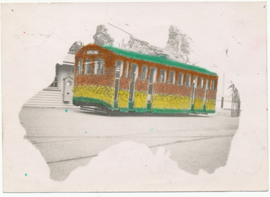 Ballarat Tramway Museum
Photograph - Digital image, L.W. Torr Best Street Bowen Hill and Brisbane Q, 4/03/1939 12:00:00 AM
Yields information about Ballarat tram 29 when it was dressed for the Floral Festival and the launch of the tram and how it was used by a small photograph publisher for sales.Digital image from the Wal Jack Ballarat Album of a postcard featuring the 1939 Floral Tram, photograph at the depot, rendered in colour and positioned within an outline of a map of Australia. Wal's notes date it as 4-3-1939. Uses the same base photo similar to 1369, but without the motor bike in the rear. On the rear has a the stamp "L.W. Torr Best Street Bowen Hill, Brisbane Q" See image i2 for rear of photograph. See Reg Item 7000 for a hand coloured image.Stamped on the rear of the photograph "L.W. Torr Best Street Bowen Hills, Brisbane Q" and the date stamp "5 May 1939"trams, tramways, floral tram, decorated trams, depot, tram 29 -
Port Melbourne Historical & Preservation Society
Photograph - 83 & 84 Evans Street, Port Melbourne, Meredith Turnbull, Dec 1996
Meredith Turnbull photographed this series in 1996 to record the rapidly changing streetscape, which had already had a number of old houses replaced by concrete two-storey structures under the State government's urban consolidation policyFrom a series of 70 colour photos recording all buildings in Evans Street from Graham Street overpass to Ingles Street, as photographed from the railway reservation, by Meredith Turnbull in December 1996 - number 83, 84, Evans StreetHouse numbers noted on backbuilt environment - domestic, meredith turnbull -
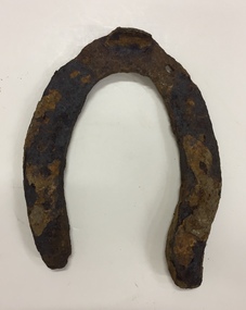 Kew Historical Society Inc
Functional object, City of Kew, Rusted Horse Shoe, Horse Tramways Shed, Kew, 1887-1950
The site on the north side of High Street, Kew, on the corner of Disraeli Street is now the location of the Kew Recreation Centre. The current (as of 2020) swimming pool was formerly situated further west on the site but was relocated closer to Disraeli Street during the 1980s. Previously, this was the site of a Kew Council depot, and before that a horse tram shed. The horse tram (1887-1914) ran from the Victoria Street Bridge to the entrance of the Boroondara General Cemetery. Rusted horse shoe, excavated from the site of the Kew Recreation Centre on the corner of High and Disraeli Streets in Kew. The shoe was donated by Mr Poulter, City Engineer, City of Kew. The shoe may have been made for one of the horses that pulled the Kew Horse Tram or one of the Council depot horses.horse tram - kew (vic), archaeological items - kew (vic), horse shoes, kew recreation centre, council depots - kew (vic), tram sheds - kew (vic) -
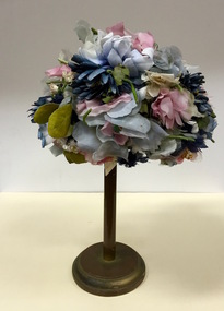 Kew Historical Society Inc
Headwear - Multicoloured Silk Floral Hat, R & M Dower, 1960s
R&M Dower was a major millinery partnership located at 146 High Street, Kew in the 1940s and 1950s. Examples of this millinery firm's hats are in other major public collections, including the National Gallery of Victoria.The Kew Historical Society’s fashion and design collection is comprised of costumes, hats, shoes and personal accessories. Many of these items were purchased or handmade in Victoria; some locally in Kew. The extensive hat collection comprises items dating from the 1860s to the 1970s. While most of the hats in the collection were created by milliners for women, there are a number of early and important men’s hats in the collection. The headwear collection is particularly significant in that it includes the work of notable Australian and international milliners.Small brimless woman’s hat retailed by R & M Dower of High Street, Kew. The structure of the hat is made of stiffened net, covered with multicoloured flowers, leaves and a purple ribbon.Label: R & M Dower, 146 High St., Kew. Phone WM 8527.r & m dower, milliners -- kew (vic.), women's clothing -- hats, headwear -
 Ringwood and District Historical Society
Newspaper, Newspaper articles detailing the acquisition of 40 acres of land for Jubilee Park, formerly known as Sanders Estate, for recreation purposes
Various newspaper articles about detals of the acquisition, by Ringwood Council, of 40 acres of land for Jubilee Park, formerly known as Sanders Estate, for recreation purposes in 1945-1959. The area included named streets - Prussia Road (not West Prussia Road), Duffy Street, Ireland Street, Evens Street and Chapman Street. -
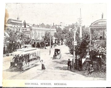 Bendigo Historical Society Inc.
Photograph - BASIL MILLER COLLECTION: ELECTRIC TRAM CLIPPING
BHS CollectionClipping showing electric tram in Mitchell Street looking from Hargreaves Street corner towards Charing Cross. J.H. Knight dentist rooms visible on corner of Bath Lane and Mitchell Street, Lazarus Building corner Hargreaves and Mitchell Streets extreme right. Printed underneath image 'Mitchell Street, Bendigo'.unknowncottage, miners -
 Orbost & District Historical Society
black and white photographs, C 1970s
3287.1 has been taken in front of the Orbost Swimming Pool. 3287.2 has been taken in Wolseley Street, Orbost and 3287.3 was photographed in Boundart Road, Orbost,These photographs are pictorial records of incidents occurring in Orbost C1970s.Three black / white photographs of tree damage in town streets. 3287.1 shows trees which been vandalised, 3287.2 and 3287 3 are photographs of storm trees which have been damaged. -
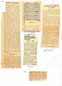
 Warrnambool and District Historical Society Inc.
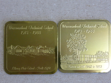
Souvenir - Warrnambool Technical School 1913-1988 souvenir coasters and placemats, 1988
These coasters and placemats are souvenirs of the 75th anniversary of the Warrnambool Technical School. The scenes depicted are Original Timor Street School built 1926, Timor Street with second storey 1967, New School built 1972. Dunkeld Annexe commenced 1975, Library new School built 1972, Annexe on Hill 1962 to 1978. They depict the ongoing development of the school which now operates as Brauer College in Caramut Road Warrnambool. Historical and social. A common item in the 20th century and as one of Warrnambool’s largest and longest running school would have some interest for a large number of local people. The artist John Moir was a local artist.Six White drink coasters with different black and white sketches. Rounded corners edged in black. In olive green box. Set two consists of two gilt metal coasters with engravings. Both are incorrectly labelled. Blue felt on the reverse. The scenes depicted are 000828.1.1 Original Timor Street School built 1926, 000828.1.2 Timor Street with second storey 1967, 000828.1.3 New School built 1972. 000828.1.4 Dunkeld Annexe commenced 1975, 000828.1.5 Library new School built 1972, 000828.1.6 Annexe on Hill 1962 to 1978. They depict the ongoing development of the school which now operates as Brauer College in Caramut Road Warrnambool. The two gilt metal coasters 000828.2.1 Library new School Built 1972 000828.2.2 Annexe on Hill 1962 to 1973 Placemats 000828.3.1 Original Timor Street School built 1926, 000828.3.2 Timor Street with second storey 1967, 000828.3.3 New School built 1972. 000828.3.4 Dunkeld Annexe commenced 1975, 000828.3.5 Library new School built 1972, 000828.3.6 Annexe on Hill 1962 to 1978.All have artist’s signature, John Moir, Warrnambool Technical School 1913-1988. warrnambool, warrnambool technical school, warrnambool annexe, timor street technical school, john moir, warrnambool souvenirs -
 Eltham District Historical Society Inc
Photograph, 1934 Floods at Eltham
Published in the Diamond Creek Basin Study, 1980 and identified at Diamond Creek, locality not identified, 1934. The location is actually looking south across the Diamond Creek towards Falkiner Street, beside the Main Road bridge at Eltham South from what is now part of Wingrove Park opposite Antoinette Boulevard. The bridge railing is just visible to the left of image. The large leaning Manna Gum beside the bridge still stands in 2021 alongside the Diamond Creek trail. In 1934 extensive flooding of the Yarra River and Diamond Creek set new records for flood plain level (Eltham Chronology, EDHS)Black and white photographCopied by Hugh Fisher, Photographer, 6 York Street Eltham A1678B Floods- Eltham - 1934floods, yarra river, eltham, flooding, diamond creek, flood -
Whitehorse Historical Society Inc.
Map, This is Vermont, 1895-1920?
'Now you have seen it, tell your friends''Now you have seen it, tell your friends' - hand-drawn map of Vermont from Springvale Road to Heatherdale Road, showing the names of owners of houses, main roads and streets, shops and schools.'Now you have seen it, tell your friends' vermont south, vermont, roads and streets -
 Surrey Hills Historical Society Collection
Photograph, Stirling Crescent, Surrey Hills in 1930s, 1930s
Paddy Slavin had a bakery at 118 Union Road, which had a rear exit onto Stirling Crescent. On the left is part of Paddy Slavin’s Bakery at 118 Union Road. The house with the hedge was that of Ada McBeath, organist for many years at the St Stephens Presbyterian and the Wyclif Churches, who lived at No.16 from 1900-1943. Phillip and Winifred Slavin are still listed in electoral roll in 1963 but by 1968 had moved to Gipps Street Collingwood, where he was still employed as a pastrycook. A black and white photograph of a street with some houses and cars on the left and electricity poles and the railway line on the right hand side.stirling crescent, surrey hills, bakery, streetscape, (ms) ada mcbeath, churches, organist, (mr) phillip slavin, (mrs) winifred slavin, streetscape, pastrycook, wyclif congregational church, (mr) paddy slavin, st stephens presbyterian church -
 Bendigo Historical Society Inc.
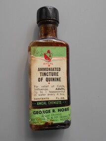
Container - PHARMACY COLLECTION: QUININE BOTTLE, 1940's
Object. Glass bottle with black plastic screw top. Green, white & red paper label, with black print Amcal ammoniated tincture of quinnine for relief of colds, influenza.Amcal Chemists. George R.Hore, 432 Collins Street, & 101 Collins Street Melbourne. Phone MU3535.medicine, first aid, quinnine bottle -
Tatura Irrigation & Wartime Camps Museum
Photograph - original, Free & Son, Frank Busam, 1940 original
Frank Busam grew first stone fruit in Tatura. Photograph given to Museum by Cr. Kevin Walker.Original sepia photograph of Frank Busamon back: Free & Son. Photographic Artists. Eastern Market, Bourke Street, 22 Greville Street Prahan.frank busam -
 Clunes Museum
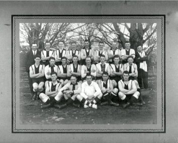
Photograph, 1930
BLACK AND WHITE PHOTOGRAPH OF FOOTBALL TEAM TAKEN AT CLUNES OVAL.On reverse: Mrs. C. Spark 15 Edward Street Footscray, late of Albert Street, North Clunes.photography, photographs, sport, football -
 Kew Historical Society Inc
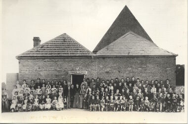
Photograph, Kew Common School, c. 1863
The Kew Common School, which had erected a new building in Peel Street only two years before the passing of the Education Act 1872, was retained and re-badged asState School No 1075, with numerous additions being made over the next few decades. This work forms part of the collection assembled by the historian Dorothy Rogers, that was donated to the Kew Historical Society by her son John Rogers in 2015. The manuscripts, photographs, maps, and documents were sourced by her from both family and local collections or produced as references for her print publications. Many were directly used by Rogers in writing ‘Lovely Old Homes of Kew’ (1961) and 'A History of Kew' (1973), or the numerous articles on local history that she produced for suburban newspapers. Most of the photographs in the collection include detailed annotations in her hand.The Rogers Collection provides a comprehensive insight into the working habits of a historian in the 1960s and 1970s. Together it forms the largest privately-donated collection within the archives of the Kew Historical Society.School photograph - The Kew Common School, located on the west side of Peel Street, Kew."Common School - Congregational Church. No.356. Photo taken early 1860s. School 356. Peel St., Rear of Congregational Church. Photo taken in early 1860s"kew common school, peel street (kew), dorothy rogers, education, kew state school -
 Kew Historical Society Inc
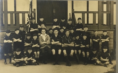
Photograph, 1st Kew Scout Group, 1st Kew Cub Pack, circa 1927, c.1927
The ‘Cubs’ was for younger boys and they wore a cap (whereas the older ‘Scouts’ wore a hat). The Disraeli Street Scout Hall was built in 1927 and remained the home of the Scout Group up until 1991. The Group now meets in a purpose-built Scout Hall (built 1993) at the corner of Willsmere Road and Kellett Grove, Kew. The new Scout Hall, currently being refurbished, proudly includes a series of solid, dark stained roof beams that came from the old hall in Disraeli Street.1st Kew Cub Pack, taken on the steps of the Disraeli Street Scout Hall. The photograph shows 24 Cubs, 3 adult leaders (who would have been 1st Kew Rovers). Nildisraeli street - kew (vic), scouts - kew (vic), 1st kew cubs -
 Kew Historical Society Inc
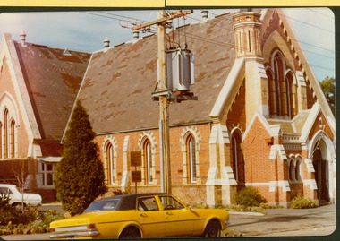
Photograph - Former Congregational Church, Walpole Street, Stewart West, 1977
The site of the former Kew Congregational Church was the earliest 'built' place of religion in Kew. An earlier building by Charles Vickers was replaced by a new brick church designed by Albert Purchas. Following the creation of the Uniting Church, the church at 30 Walpole Street was declared redundant and demolished to make way for the Bodalla Nursing Home (itself later demolished).Colour print positive of the former Congregational Church in Walpole Street, Kew. The front of the polychrome brick building showing the small steeple and the front entrance."Oldest church in Kew. Victoria. Taken Oct '77. Formerly Congregational Church"churches -- kew (vic), congregational churches, walpole street -- kew (vic), albert purchas