Showing 11136 items
matching planning
-
 Department of Energy, Environment and Climate Action
Displan STTO emergency radio (c 1976)
After the 1939 bushfires, the Forests Commission Victoria invested heavily in a radically new communications network. After suffering some inevitable delays due to the war, radio VL3AA switched into full operation in October 1945 proudly beaming out 200 watts across the State. But by today’s standards, the technology was primitive and the reception poor unless the user was on a high point somewhere. The radio signal was "line-of-sight" and bounced between fire towers and relay transmitters across the mountains back to the District offices. The advent of solid-state electronics in the 1960s replaced the more delicate valve sets which enabled greater use of vehicle mounted radios. The Commission continued to research, develop and build new radios at its many workshops around Victoria. The network was supported by a large team of skilled radio technicians. The more secure and versatile State Mobile Radio (SMR) digital trunk system came into operation in about 1995. Upgraded Tait Radios were purchased in 2014 after recommendations of the 2009 Bushfires Royal Commission. But it was the convergence of separate technologies such as 5G mobile phones, high-capacity and light-weight lithium batteries, Wi-Fi, the ever-expanding internet, cloud data storage, digital cameras, GPS, personal organisers and hundreds of supporting Apps into powerful smartphones and tablets which revolutionised bushfire communications from the mid-2000s. State Disaster Plan (DISPLAN) radio in metal carry casebushfire, radios, forests commission victoria (fcv) -
 Bendigo Historical Society Inc.
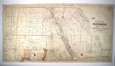
Map - PARISH OF RAVENSWOOD, Circa 1908
Map: Parish of Ravenswood, Counties of Bendigo and Talbot. Parish planmap, bendigo, parish plan, ravenswood, county of talbot -
 Bendigo Historical Society Inc.
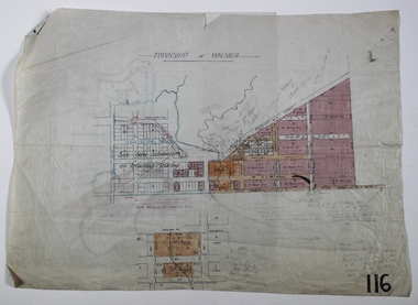
Map - WALMER, Circa 1900
Map: Township of Walmer, 2 hand Draughted Parish plansmap, township, walmer -
 Bendigo Historical Society Inc.
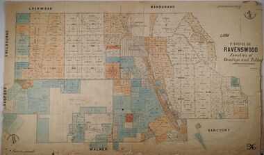
Map - PARISH OF RAVENSWOOD, 3/04/1875
Map: Parish of Ravenswood, Counties of Bendigo and Talbot. Parish planmap, bendigo, parish plan, ravenswood, county of talbot, county of bendigo -
 Port Melbourne Historical & Preservation Society
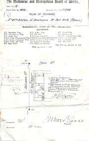
Plan - MMBW Drainage plan for 184 Dow Street Port Melbourne
Melbourne Metropolitan Board of Works plan for 184 Dow Street.mmbw, engineering - melbourne metropolitan board of works, dow street -
 Ringwood and District Historical Society
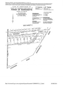
Document - Subdivision Plan, LP7604 Part of Crown Portion 31B, Parish of Warrandyte, County of Evelyn, Vol 3954 Fol 626 - 2019
A4 LANDATA Land Victoria plan printout dated 2010Map includes Derwent Street and Warrandyte Road, Ringwood. Although marked See Sheet 2, no other page included with collection. -
 University of Melbourne, Burnley Campus Archives
Plan - Photocopy, Burnley Site, c.1970s
Part B. Photocopy of plan of site with proposed changes marked on it.buildings, burnley gardens -
 Eltham District Historical Society Inc
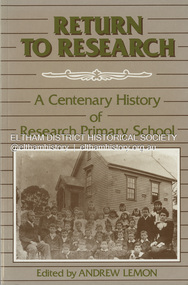
Book, Hargreen Publishing, Return to Research : a centenary history of Research Primary School / edited by Andrew Lemon, 1989
Paperback; 104 p. : ill., plans, ports. , ; 21 cm.ISBN 0949905437 : 0731671805 (Research Primary School)research (vic.), research primary school, schools, state school no. 2959, centenary celebrations -
 Whitehorse Historical Society Inc.
Photograph, East Burwood Pre School
Black and white photo of East Burwood Pre-School Planeast burwood preschool, plans -
 Ringwood and District Historical Society
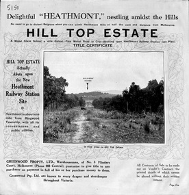
Pamphlet, Atlas Press Pty. Ltd., Melbourne, Land Sale Brochure, Hill Top Estate, Heathmont, Vic. - circa 1925
Twelve page land sale brochure promoting Heathmont and Ringwood area including photographs, subdivision features and local facilities. Subdivision plan includes Heathmont Road, Balfour Avenue, Edith Street, Edna Street, and Great Ryrie Street. -
Port Melbourne Historical & Preservation Society
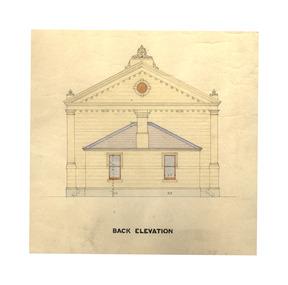
Plan - Town Hall, Sandridge, 1860s
Photos of Longitudinal, traverse, side and back elevation drawings for original Town Hall, Sandridge (No. 2); a record of appearance of .01 before treatment by conservators William Ireland:Witness Henry Bates:Reverse side: Plans of Town Hall, old and new. June 19th (pencil drawing)port melbourne town hall, built environment - civic -
 Port Melbourne Historical & Preservation Society
Plan - Town Hall, Sandridge, 1860s
Longitudinal, traverse, side and back elevation drawings for original Town Hall, Sandridge 1869 (No. 2) William Ireland:Witness Henry Bates:Reverse side: Plans of Town Hall, old and new. June 19th (pencil drawing)port melbourne town hall, built environment - civic, sandridge town hall -
 Melbourne Tram Museum
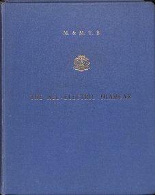
Document - Report, Melbourne & Metropolitan Tramways Board (MMTB), "The All-Electric Tramcar", 1961
Report - blue Rexene cloth heavy card covers, dark blue glued end sheets, fully sewn bound, with some 9 sections, with many sheets folded and appropriate paper spacing allowed for in the binding. Report titled "MMTB The ALL-ELECTRIC TRAMCAR" with MMTB logo in gold block on front cover and on the side of the report. About 150 pages. Report prepared by Frank R. Kirby Chief Engineer, December 1961. Has a table of Contents, Appendices, figures, tables and photographs. Report looks at the development of All Electric Tramcars in Europe and North America, the cost of maintenance of Melbourne's trams, operating costs, conductors, seated conductors, passenger handling, reliability, speeds, maintenance and capital costs.Has a lable on the first page, "Plan & EPA Library M0036918", Front cover stamped in red "Secretary's Files"trams, tramways, mmtb, pcc, germany, europe, all electric trams, prototype tramcar -
 Echuca Historical Society
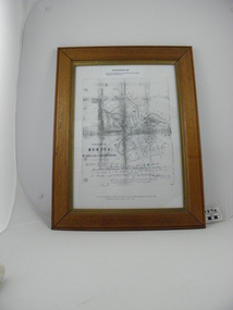
Map, Map of Township - Echuca
Map on white paper that has yellowed. Black print Handwriting is black but faded. In wooden frame behind glass. Printed Survyor's plan for Echuca Township, date 5th March 1855, from the Surveyor General Office. Melbourne March 5th 1855 Plan drawn by P Chauncey. Hand written- This plan is now a Port for the South Australian Steamer Trade - when Hopwood settled here/ it was only a wild bush - he is now throwing a bridge/ at his own cost across this river 200yards wide. signed by Henry Hopwood. Typed on backing paper: Plan of the township of ECHUCA dated March 1855, One month before the first land sales / Autographed by Henry Hopwood in Oct 1955. -
 Eltham District Historical Society Inc
Slide - Photograph, Eltham Shire Council, Tentative plan of subdivision, part of Crown Allotment 22, Section B, Parish of Greensborough, County of Evelyn, 1969
... planning ...35mm colour positive transparency blue Agfacolour Service plastic mountE11, N1069, Stogryn, Sub 'prop',infrastructure, map, planning, subdivison lots -
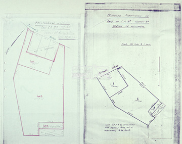 Eltham District Historical Society Inc
Slide - Photograph, Eltham Shire Council, Proposed subdivision of Part of Crown Allotment 8B, Section 8A, Parish of Nillumbik, 1969
... planning ...35mm colour positive transparency blue Agfacolour Service plastic mountE4, N0424, Stock subdivision, North Warrandyte, 4 August 1969infrastructure, map, planning, subdivison lots -
 Bendigo Military Museum
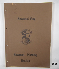
Manual - MOVEMENT PLANNING HANDOUT, Australian Army
... Planning ...This is a book made by Army School of Transport. The cover is a thin cardboard, coloured brown. Printing is in black ink. In the centre is a form of shield. On top is a banner with words "Army School of. At the bottom is the word "Transport". It has approx 44 pages of black and white photos and specifications of equipment. i.e. Aircraft, Trucks, APC road rovers, Trailers, Tractors, Graders, Water Craft etc.passchendaele barracks trust, transport, planning, equipment specs -
 Bendigo Historical Society Inc.
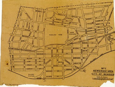
Newspaper - BENDIGO SEWARAGE AREA NEWSPAPER CUTTING, 1921
... Planning ...Newspaper cutting showing map of the No 1 Sewerage Area City of Bendigo. 1921bendigo, planning, sewerage, bendigo sewerage -
 Melbourne Tram Museum
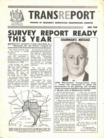
Pamphlet, Minister of Transport, Transport, Jun. 1968
... Planning ...Transport - produced by Melbourne's Metropolitan Transportation Committee. 4 page brochure describing Melbourne's transport survey - "Blue-print for the Future".trams, tramways, reports, planning -
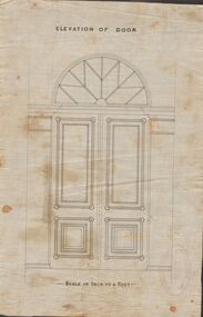 Bendigo Historical Society Inc.
Document - MARKS COLLECTION: DRAWING FOR ELEVATION OF DOOR
Drawn on waxed paper. On top of plan 'Elevation of Door' printed in black ink, on bottom 'Scale an inch to a foot'. Plan shows double doors, arched window above. Contained in items from Fortuna Villa, although not marked as such. On bottom of plan purple ink stamp 'Vahland & Getzschmann, Architects, Sandhurst'.Vahland & Getzschmann, Architects, Sandhurst.bendigo, house, fortuna villa -
 Bendigo Historical Society Inc.
Plan - Bendigo East State School Plans 1915
A photocopy of a hand drawn coloured plan of Bendigo East State School No. 3893 dated 24th April 1915 showing various elevations and sections. Written on the plan are the names Joseph William Fairbanks (building contactor) and J. Hudspeth. The sum of 1097 pounds is also written on the plans. Gemma Starr Collectionbendigo east state school, bendigo schools, gemma starr collection, 1915 bendigo east state school, school plan, joseph william fairbanks -
Whitehorse Historical Society Inc.
Document, 520 Mitcham Road, 1/01/2008 12:00:00 AM
Documents relating to the Planning Permit Application for demolition of an existing dwelling and the development of 52 dwellings at 520-528 Mitcham Road Mitcham, January 2008.Documents relating to the Planning Permit Application for demolition of an existing dwelling and the development of 52 dwellings at 520-528 Mitcham Road Mitcham, January 2008. Contains: VCAT Finding 31 Jan 2008; VCAT Evidence Report by Coomes Consulting Group; Aboricultural statement by Treelogic Pty. Ltd.;Statement of expert design evidence by Hansen Partnership, engaged by the City of Whitehorse; Statement of town planning evidence prep. by Hansen Partnership; Urban design evidence prep. by Message Consultants; Report to VCAT [expert traffic evidence] by Cardno Grogan Richards; Draft conditions by Maddocks, Lawyers for City of Whitehorse; Report, John Patrick Landscape Architects.Documents relating to the Planning Permit Application for demolition of an existing dwelling and the development of 52 dwellings at 520-528 Mitcham Road Mitcham, January 2008. city of whitehorse, town planning, mitcham road, mitcham, no. 520-528 -
University of Melbourne, Burnley Campus Archives
Plan, Royal Horticultural Society's Garden
Changed boundaries of the site burnley gardens, survey paddock, flood, lynch design, richmond park, yarra river -
Whitehorse Historical Society Inc.
Article, 50th wedding anniversary, 5/05/1999 12:00:00 AM
50th wedding anniversary of Noel and Jean Webster.50th wedding anniversary of Noel and Jean Webster. He was Nunawading's mayor, 1973-74 He was a founding member of the school council at Vermont High School and board member at Maroondah Hospital. Also a Justice of the Peace and involved with U3A. Founding member of Early Planning for Retirement organization. Jean served as President of Nunawading Historical Society and an active member of St Luke's church.50th wedding anniversary of Noel and Jean Webster. mayors, webster, noel, webster, jean, vermont high school, maroondah hospital, early planning for retirement, nunawading historical society, st lukes anglican church, vermont -
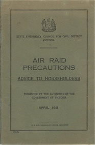 Warrnambool and District Historical Society Inc.
Booklet, Air Raid Precautions, 1941
This booklet was published on the recommendation of the Commonwealth government as part of a plan to offer protection to the people in the event of air strikes. Local councils and individuals were called to help to protect themselves in taking precautions,. The booklet itself sets out action to be taken in the event of an air raid happening, lighting restrictions fire prevention, refuge rooms and garden shelters and risks from air raids. It contains the relevant siren signals which denote different types of events and explains in detail various aspects of preparing for possible attack. There was discussion about issues such as evacuation of children should such an event occur with the focus primarily on the larger centres such as Geelong and Melbourne. From 1942 the number of air attacks increased mainly from Japan on the northern and western parts of Australia including over 60 on Darwin. Attacks continued into 1943 and it wasn’t until later in that year that the Prime Minister, John Curtin announced that the threat of invasion had passed.While the link to Warrnambool’s history is tenuous, it was a government publication to all persons in the state of Victoria in 1941.This item relates to a significant period in Australia’s history. All Australians were affected by the war. It has historical and scientific or research interest as it gives a number of diagrams and possible plans and the effectiveness of same. Olive green soft card cover with black text. 36 pages, with 2 extra pages depicting plans for shelters pasted inside back cover. Victorian coat of arms at top of cover.April 1941. H. E. Daw, Government printer. Forward by Sir John Harris KBE MLC Minister of Public Instruction and Public Healthhistory of warrnambool, air raid precautions 1941 -
Port Melbourne Historical & Preservation Society
Document - Report, Ewan Ogilvy's Bayside Papers, Bayside EES Inquiry, Ewan Ogilvy's Bayside Papers, Box One, 1988
Ewan Ogilvy, former Melbourne Councillor and also of Community Services Victoria, Inner Urban Ministerial Advisory Committee and Uniting Church's Centre for Urban Research and Action (CURA), was instrumental in social justice approaches to town planning. He and CURA's Social Justice and the City Project funded Port Melbourne community groups protesting against the SCDC development in 1987. His files were presented to the Society in May 2001 on his preparation for leaving Victoria.From Ewan Ogilvy's chronologically organised 'Bayside Papers' relating to the proposed development of Port Melbourne industrial land in the late 1980s: EES Inquiry report to the Minister for Planning and Environment 7 April 1988, included in bound black file. Appendix 3: list of those appearing before the inquiryAll items signed 'Ewan Ogilvy'town planning, town planning - proposals shelved - bayside, public action campaigns, environmental issues, public housing, ewan ogilvy, centre for urban research and action, sandridge city development co pty ltd, scdc, linton r lethlean, judy arndt, francis b barnes -
Port Melbourne Historical & Preservation Society
Letter - Roper to Lethlean re Bayside EES Inquiry, Ewan Ogilvy's Bayside Papers, Box One, 1988
Ewan Ogilvy, former Melbourne Councillor and also of Community Services Victoria, Inner Urban Ministerial Advisory Committee and Uniting Church's Centre for Urban Research and Action (CURA), was instrumental in social justice approaches to town planning. He and CURA's Social Justice and the City Project funded Port Melbourne community groups protesting against the SCDC development in 1987. His files were presented to the Society in May 2001 on his preparation for leaving Victoria.From Ewan Ogilvy's chronologically organised 'Bayside Papers' relating to the proposed development of Port Melbourne industrial land in the late 1980s: EES Inquiry report to the Minister for Planning and Environment 7 April 1988, included in bound black file. Appendix 7: letter Roper to Lethlean March 88All items signed 'Ewan Ogilvy'town planning, town planning - proposals shelved - bayside, public action campaigns, environmental issues, ewan ogilvy, centre for urban research and action, sandridge city development co pty ltd, scdc, linton r lethlean, judy arndt, francis b barnes, tom roper -
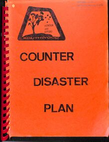 Ringwood and District Historical Society
Manual, Southwood Primary School, Ringwood - Counter Disaster Plan Manual (undated - circa - post 1983) (Later version than 11626)
Bound Manual describing evacuation and emergency procedures. Includes Action Plan, Staff members, Instructions, Types of Threats and school building plan. Similar content (but later version) to VC 11626 -
Clunes Museum
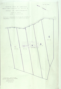
Plan - PLANS CLUNES CARAVAN PARK, NO. 1 - SHIRE OF TALBOT & CLUNES. IAN MANSLEY, SHIRE ENGINEER NO. 2 - LEO MCMAHON & ASSOCIATES PTY. LTD. LICENSED SURVEYORS & ENGINEERS, 31 LYONS ST. NTH. BALLARAT, 1976
NO. 1 PLAN - CLUNES CARAVAN PARK ENGINEER - IAN MANLEY NO. 2 PLAN - SECTION 15 TOWNSHIP OF CLUNES, COUNTY OF TALBOT, BY LEO MCMAHON AND ASSOCIATES, LICENSED SURVEYORS AND CIVIL ENGINEERSplans, caravan park, ian manley, plan section 15 -
Whitehorse Historical Society Inc.
Pamphlet, Halliday Park, c1988
A pamphlet describing Halliday Park in Mitcham outlining its history and plans for its development as a city park. Members of the Committee of Management are listed and the verso has the concept plan being developed.A pamphlet describing Halliday Park in Mitcham outlining its history and plans for its development as a city park. Members of the Committee of Management are listed and the verso has the concept plan being developed.A pamphlet describing Halliday Park in Mitcham outlining its history and plans for its development as a city park. Members of the Committee of Management are listed and the verso has the concept plan being developed.halliday park, city park