Showing 23722 items
matching creeks
-
 Victoria Police Museum
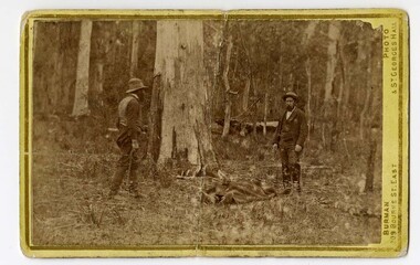
Carte de Visite (body of Michael Kennedy), Burman Photo, 1878
Small black and white photograph on cardboard showing two standing figures with the covered body of Sergeant Michael Kennedy in the middle. Photograph is taken at Stringybark Creek and shows a bushland settingFinding of Kennedy's Body (written in black ink on rear)stringybark creek, michael kennedy, police murders, kelly gang, bushrangers -
 Orbost & District Historical Society
black and white photograph, late 19th - early 20th century
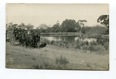
This photograph was taken at the junction of the Snowy and Brodribb Rivers. The Snowy River starts in New South Wales on the slopes of Mt Kosciuszko, Australia’s highest mountain, in New South Wales. It flows into Bass Strait at Marlo in Victoria. The Brodribb River is a tributary of the Snowy which enters the estuary at Marlo. This is a pictorial record of a road in Marlo near Orbost in the late 19th-early 20th centuries. It also depicts the transport used at that time.A black / white photograph of four men in suits seated in a horse - drawn buggy on a dirt road alongside a creek or river. There appears to be another horse - drawn vehicle behind them.on back - "at the Brodribb - Snowy junction. this road was corduroy (packed logs of tea trees?)brodribb-river snowy-river marlo transport-horse-drawn -
 Federation University Historical Collection
Booklet, Graeme Wynn, Life on the Goldfields: Fifteen Letters 1853 - 1861, 1853 -1861 (original)
Yellow soft covered booklet of 11 pages, containing transcriptions of fifteen letters written by James William Robertson between 1853 and 1861. Many of the letters relate to Creswick Creek.Inside front cover :Gill you will find some interesting references to the Anderson family with complimetns. Tom Evans. goldfields, james robertson, james william robertson, creswick, correspondence, anderson, m -
 Coal Creek Community Park & Museum
Mine Map, 1942
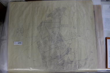
6291.1 - Plan of "Austral Coal Mining Co" Lease in Korumburra detailing the mine tunnel plan, coal seam areas and some surface features such as railway sidings & Leura Creek. -
 Coal Creek Community Park & Museum
Mine Map
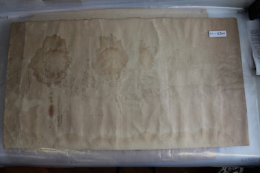
6306.1 - Map of Outtrim mining area, with modification where damage/erasure has occurred. Shows tunnels, faults, tramways, boreholes, surface roads and (apparently) paddock boundaries and a creek. -
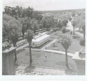 Bendigo Historical Society Inc.
Photograph - BENDIGO VIEWS COLLECTION: THE BENDIGO CONSERVATORY, 1940's
Photograph. With an abundance of trees, the Bendigo Conservatory sits in the middle of the photo. Concrete paths are around the building and to the outside of the garden. The Bendigo creek is at the side of the building. On left is part of the Court House.photograph, landscape, confectonary and gardens. -
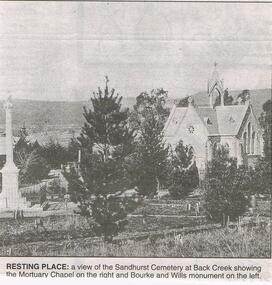 Bendigo Historical Society Inc.
Newspaper - JENNY FOLEY COLLECTION: RESTING PLACE
Bendigo Advertiser "the way we were" from 1999. Resting place: a view of the Sandhurst cemetery at Back Creek, showing the Mortuary Chapel on the right and Bourke and Wills monument on the left.newspaper, bendigo advertiser, the way we were -
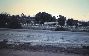 Bendigo Historical Society Inc.
Slide - BENDIGO VIEWS, Jun 1961
Slide. Bendigo Views. Sportsground with a football match in progress. Cars around the fence on the far side of the ground. A small creek on the near side of the ground. Trees and shrubs around the ground.slide, bendigo, bendigo views, bendigo views -
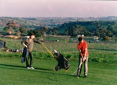 Hume City Civic Collection
Photograph, early 1980s
The series of photographs were taken shortly after the opening of the newly established Goona Warra Golf Club in the early 1980s. The golf club was part of the Goonawarra Housing Estate which was developed on the area previously known as Goonawarra Farm. The new golf club replaced 'The Pines' which was part of the Caloola complex.A coloured photograph of two golfers. One is preparing to hit off while the other is standing in the background with the golf buggy. They are standing overlooking the Goonawarra and Craiglea vineyards and the Jacksons Creek valley.goona warra golf club, george evans collection -
Whitehorse Historical Society Inc.
Legal record - Document, Certificate of Title, 1977
Certificate of Title vol. 5564 fol. 1112691 for part of Lot 13 Plan of Subdivision no. 4488, cnr. Creek Road and East Road Mitcham, owned by George Albert SmithCertificate of Title vol. 5564 fol. 1112691 for part of Lot 13 Plan of Subdivision no. 4488, cnr. Creek Road and East Road Mitcham, owned by George Albert SmithCertificate of Title vol. 5564 fol. 1112691 for part of Lot 13 Plan of Subdivision no. 4488, cnr. Creek Road and East Road Mitcham, owned by George Albert Smithcreek road mitcham, smith, george albert, east road mitcham -
 Whitehorse Historical Society Inc.
Letter - Correspondence, Warrandyte, 1/08/1857
Letter from Survey Office dated 1 August 1857 referring to auriferous indications on each side of Deep Creek revealed in the course of a survey of roads to the Warrandyte Gold Fields.warrandyte, goldmining, deep creek, nunawading -
 Whitehorse Historical Society Inc.
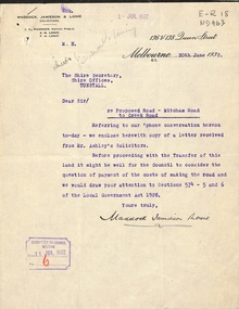
Letter - Correspondence, Mitcham Road, 1932
Correspondence between Shire Secretary, Shire of Blackburn and Mitcham and vendors and their solicitors re transfer of land for a road between Mitcham Road and Creek Road, Mitcham, June - July 1932.mitcham road, mitcham, creek road, mitcham, shire of blackburn and mitcham, maddocks, jamieson & lonie, solicitors, ashley (mr), bloom, f.a., roads and streets -
 Southern Sherbrooke Historical Society Inc.
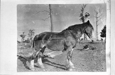
Photograph - The Breen's draught horse, Violet
The photo shows a large draught horse in profile, standing in a paddock. Scattered trees stand in the distance beyond the paddock fences. This is the Breens' draught horse Violet, probably at Menzies Creek. -
 Bendigo Historical Society Inc.
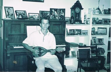
Photograph - PETER ELLIS COLLECTION: CRAIG BAKER
Black and white photo of Craig Barker sitting in front of a piano playing a mandolin. Many framed photos and an old clock in the background. Craig Barker Emu Creek written on the back.photo, individual, craig barker, peter ellis collection, craig barker, emu creek -
 Bendigo Historical Society Inc.
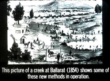
Slide - DIGGERS & MINING. GETTING THE GOLD, c1854
Diggers & Mining. Getting the Gold. Slide: This picture of a creek at Ballarat (1854) shows some of these new methods in operation. Markings: 45 994.LIF:4. Used as a teaching aid.hanimounteducation, tertiary, goldfields -
 Bendigo Historical Society Inc.
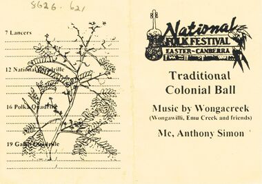
Document - PETER ELLIS COLLECTION: NATIONAL FOLK FESTIVAL
Yellow dance card with black printing for the National Folk Festival, Easter Canberra, Traditional Colonial Ball, music by Wongacreek, Wongawilli, Emu Creek and friends, Mc, Anthony Simon.entertainment, dance, folk festival -
 Bendigo Historical Society Inc.
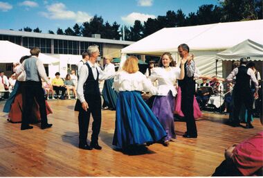
Photograph - PETER ELLIS COLLECTION: BUSH DANCE
Colour photograph . People dancing. Wooden stage. Crowd watching. Back of photo reads: 6/1 Bendigo Bush Dance & Music Club with Emu Creek at the NFF Canberra.photo, group, dance -
 Bendigo Historical Society Inc.
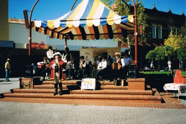
Photograph - PETER ELLIS COLLECTION: EMU CREEK BUSH BAND
Colour photograph. Blue, white and yellow marquee. Hargreaves Mall. Emu Creek Bush Band. Crier. Back of photo reads: Hargreaves Mall- Bendigo with town crier Tom.entertainment, music, emu creek bush band -
 Bendigo Historical Society Inc.
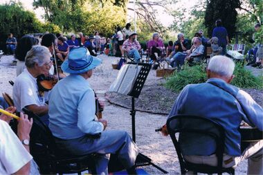
Photograph - PETER ELLIS COLLECTION: BAND PLAYING OUTSIDE, 23rd March, 2002
Colour photograph. People sitting in chairs around garden. Instruments. Music sheets. Back of photo reads: Emu Creek. 'Buda' Castlemaine 23rd March 2002 Twilight Concertentertainment, music, musicians -
 Bendigo Historical Society Inc.
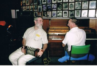
Photograph - PETER ELLIS COLLECTION: PETER ELLIS
Colour photograph. Wall of photos. Peter Ellis concertina. Man at keyboard. Green chair. Back of photo reads: Peter Ellis - Emu Creek Stuart Simms - Gay Charmersentertainment, music, musicians -
 Bendigo Historical Society Inc.
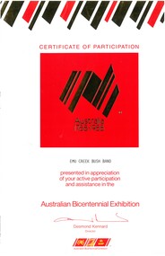
Document - EMU CREEK BUSH BAND COLLECTION: AWARDS AND CERTIFICATES, 1988
Documents. Sixty one letters and certificates of appreciation for the Emu Creek Bush Band following perfromances at a varity of venues and schools across Victoria, New South Wales and South Australia. -
 Bendigo Historical Society Inc.
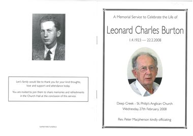
Booklet - Leonard Charles Burton
Funeral Service Booklet - a Memorial Service to Celebrate the Life of Leonard Charles Burton 1.4.1923 - 22.2.2008 Deep creek St Phillips Anglican Church Wednesday 27th February. 2008.leonard charles burton, funeral service booklet -
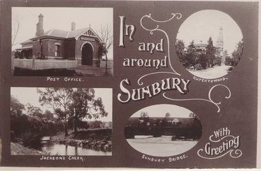 Sunbury Family History and Heritage Society Inc.
Photograph
A post card featuring four were known scenes of Sunbury including the post office, Rupertswood Mansion, Macedon Street Bridge andJacksons Creek. A greeting is also printed on the card.IN/AND/AROUND/SIUNBURY/WITH /GREETINGS -
 Stawell Historical Society Inc
Photograph, Students at Pleasant Creek Training Centre 1937-1942
Mrs Jean Black was a Student at Pleasant Creek Special School from 1937 to 11942. Probably sent there as an Orphan rather than due to a disability. Maiden name was Loveland Former Pleasant Creek Hospital site. Sometimes referred to as Pleasant Creek Special School and sometimes Pleasant Creek Training Centre.Set of Black and White Photographs 1941 - 1944education -
 Eltham District Historical Society Inc
Negative - Photograph, J.A. McDonald, Eltham-Diamond Creek Road, May 1958
Bridge construction Eltham-Diamond Creek road over the Diamond Creek (Wattletree Road), Eltham, May 1958 Looking toward Eltham-Yarra Glen Road from Diamond Creek abutmentRecord of various Shire of Eltham infrastructure works undertaken during the period of 1952-1962 involving bridge and road reconstruction projects, sometimes with Eltham Shire Council Project Reference numbers quoted. It was during this period that a number of significant improvements were made to roads and new bridges constructed within the shire that remain in place as of present day (2022). In many situations, the photos provide a tangible visible record of infrastructure that existed throughout the early days of the Shire. The album was put together by or under the direction of the Shire Engineer, J.A. McDonald.1958-05, bridge construction, diamond creek (creek), eltham, eltham north, glen park bridge, infrastructure, shire of eltham, wattletree road bridge -
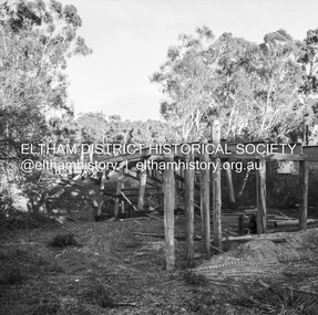
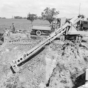 Eltham District Historical Society Inc
Negative - Photograph, J.A. McDonald, Dixons Creek Road, c.May 1958
Bridge over Dixons Creek Contractor Morris Gradall cutting batters on Dixons CreekRecord of various Shire of Eltham infrastructure works undertaken during the period of 1952-1962 involving bridge and road reconstruction projects, sometimes with Eltham Shire Council Project Reference numbers quoted. It was during this period that a number of significant improvements were made to roads and new bridges constructed within the shire that remain in place as of present day (2022). In many situations, the photos provide a tangible visible record of infrastructure that existed throughout the early days of the Shire. The album was put together by or under the direction of the Shire Engineer, J.A. McDonald.infrastructure, shire of eltham, 1958-05, bridge construction, dixons creek bridge, dixon's creek road, gradall -
 Melbourne Tram Museum
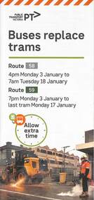
Pamphlet, Yarra Trams, Buses Replace Trams - Routes 58, 59, 86 and 96, 2022
.1 - pamphlet provided at tram stops giving details of the works and bus services for routes 58 and 59 .2 - Project document describing the work and dates - downloaded from the Yarra Trams website after buses were used to replace route 58 from the Royal Children's Hospital rather than from Royal Park Station as originally planned. .3 - as for .1 - for the upgrading of the Merri Creek Bridge - route 86 - see also Reg Item 6066 .4 - as for .1 - for the installation of superstops in Nicholson St between Elgin St and Holden St - route 96Shows the methods that Yarra Trams customers are advised of changes due to track replacement works..1 - Pamphlet - DL, four fold printed on off white paper titled - Buses Replace Trams - Route 58 and Route 59 - Jan 2022 .2 - Project sheet - 3 A4 sheets, titled "Renewal works: Essendon Depot and Mt Alexander Road - 3.1 to 18.1.2022. .3 - Pamphlet - DL 3 fold, Buses Replace Trams, route 86, November 2021 - Merrit Creek Bridge works .4 - Pamphlet - DL - 4 fold, Buses Replace Trams, route 96, January 2020 - Nicholson St works for tram super stops.mt alexander road, tram works, track work, route 58, route 59, yarra trams, ptv, essendon tram depot, route 86, route 96, nicholson st, merri creek, bridges, carlton, super stops, trams, tramways, northcote -
Eltham District Historical Society Inc
Document - Folder, Roberts, Nese
Diamond Creek resident Nese Roberts was awarded the Rotary Club of Diamond Creek's fourth courtesy and kindness award for service to the community. Contents Newspaper article: "Award to Diamond Creek's Nese," Ash Long's Advertiser, 3 December 1996. Nese Roberts awarded for service to the community by the Rotary Club of Diamond Creek.Newspaper clippings, A4 photocopies, etcnese roberts, rotary club of diamond creek, terry wade, eileen rainsbury, ern wardell, st vincent de paul, diamond valley interchurch group, red cross, sacred heart church, save the children fund, wattle glen nursing home, steve kennedy, mark pittle, john puls, very molinaro, doug blakie, mick hall, ken nettleton, jill pittle, michael hannan, maurie roadley, moya roadley, dawnville nursing home -
 Federation University Historical Collection
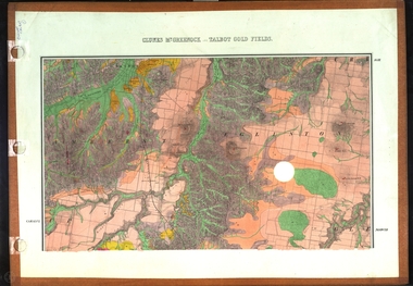
Map, Clunes, Mt Greenock, and Talbot Gold Fields, 1883
A geological plan of the Clunes, Mt Greenock, and Talbot Gold Fields in two parts. .1) This section of the map includes Talbot, Talbot water supply race, Mt Glasgow, Little Green Hill, Middle Hill, Mt Cameron, Ballarat Hill, Bakery Hill, Goodwoman Hill, Scandanavian Lead, Eglinton Swamp, McCallum's Creek, Tullaroop Creek, Dunach, Maryborough Railway, Middle Creek and includes many mines such as Rip Van Winkel, Union Extended, South Greenock, Nicholl's Freehold. .2) This section of the map includes McCallums, Clunes, Green Hill, Mt Beckworth, Mt Gap, Maryborough Reservoir, and includes mines such as Lothair, Bute, Clyde, Clunes Consols, London and Australian, Oriental,clunes, talbot, water supply, railway, geology