Showing 2228 items
matching map of bendigo
-
 Bendigo Historical Society Inc.
Map - PASTORAL HOLDINGS, See above
... Inc. History House 11 Mackenzie Street Bendigo goldfields MAP ...Map: Copy of 'Map showing the Pastoral Holdings of the Port Phillip District 1835-51, Now Victoria'. Comiled by A.S.Kenyon M.I.E. Aus. Historical society of Victoria 1932map, victoria, pastoral holdings, pastoral holdings, port phillip district -
Bendigo Historical Society Inc.
Map - RAYWOOD, 18/09/1930
... Inc. History House 11 Mackenzie Street Bendigo goldfields MAP ...Map: Township of Raywood, Parish of Neilborough,County of Bendigo. Parish plan (number 270 in map cupboard 1)map, bendigo, township, raywood -
Bendigo Historical Society Inc.
Map - WALMER, Circa 1900
... Inc. History House 11 Mackenzie Street Bendigo goldfields MAP ...Map: Township of Walmer, 2 hand Draughted Parish plansmap, township, walmer -
Bendigo Historical Society Inc.
Map - NEWSTEAD, 28/07/1874
... Inc. History House 11 Mackenzie Street Bendigo goldfields MAP ...Map: Newstead Town and Suburban Lots, Parish of Strangways. Parish planmap, township, newstead -
Bendigo Historical Society Inc.
Map - PROPOSED TOWNSHIP PARISH OF CAMPASPE, 24th May 1875
... Inc. History House 11 Mackenzie Street Bendigo goldfields MAP ...Map: Proposed Township, Parish of Campaspe(This has been crossed out and 'Creek View' written above). Hand Draughted Parish plan Stapled to the backingmap, township, proposed township, campaspe, creek view -
Bendigo Historical Society Inc.
Map - GOORNONG, 1/10/1906
... Inc. History House 11 Mackenzie Street Bendigo goldfields MAP ...Map: Town of Goornong, Parish of Goornong, County of Bendigo. Parish plan (number 269 in map cupboard 1)map, bendigo, township, goornong -
Bendigo Historical Society Inc.
Map - STRATHFIELDSAYE, See above
... Inc. History House 11 Mackenzie Street Bendigo goldfields MAP ...Map: Township of Strathfieldsaye, Group of 4 plans, 2 hand drafted and 2 printed. Applied to canvas and stapled to the backing. The printed plans are dated January 1859 and 6th January 1871 (number 267 in map cupboard 1)map, bendigo, township, strathfieldsaye -
Bendigo Historical Society Inc.
Map - RAVENSWOOD, April 6th 1872
... Inc. History House 11 Mackenzie Street Bendigo goldfields MAP ...Map: Township of Ravenswood. Parish plan, has a 1913 calendar as a backing (number 266 in map cupboard 1)map, bendigo, township, ravenswood -
Bendigo Historical Society Inc.
Map - HARCOURT, No date visible
... Inc. History House 11 Mackenzie Street Bendigo goldfields MAP ...Map: Township of Harcourt, Parish pf Harcourt, County of Talbot, (number 265 in map cupboard 1)map, talbot, township, harcourt -
Bendigo Historical Society Inc.
Map - HARCOURT, 2/04/1917
... Inc. History House 11 Mackenzie Street Bendigo goldfields MAP ...Map: Town of Harcourt, County of Talbot. Parish plan (number 264 in map cupboard 1)map, talbot, township, harcourt -
Bendigo Historical Society Inc.
Map - NEWSTEAD, 15/10/1912
... Inc. History House 11 Mackenzie Street Bendigo goldfields MAP ...Map: Town of Newstead, Parish of Strangways, County of Talbotmap, talbot, township, newstead, county of talbot -
Bendigo Historical Society Inc.
Map - SURVEY OF MINES, SANDHURST, NEW CHUM, Circa 1881
... Inc. History House 11 Mackenzie Street Bendigo goldfields MAP ...Map: Survey of Mines, Sandhurst, New Chum, Longtitudinal Section of the New Chum, reef. 2 sheets. Sheet 5 and Sheet 8map, mining plan, survey of mines , sandhurst, new chum, gold mines bendigo -
Bendigo Historical Society Inc.
Map - NEW CHUM LINE, 1875
... Inc. History House 11 Mackenzie Street Bendigo goldfields MAP ...Plan: Longtitudinal section of the Southern Section of the New Chum Line of Reef. Compilation consisting of small sections stapled togetherCALEB THOMAS 1875map, mining plan, gold mines, new chum line -
Bendigo Historical Society Inc.
Map - NEW CHUM LINE, 1875
... Inc. History House 11 Mackenzie Street Bendigo goldfields MAP ...Plan: Longtitudinal Section of the Northern Section of the New Chum Line of Reef. Compilation consisting of smaller sections stapled togethermap, new chum line, gold mines, new chum line of reef -
Bendigo Historical Society Inc.
Map - PLAN OF BENDIGO CREEK, 12th March 1873
... Inc. History House 11 Mackenzie Street Bendigo goldfields MAP ...Map:Hand drafted plan of the Bendigo Creek, covering from Scott St. White Hills to Alder St. Kangaroo Flat. Scale 2 chains to 1 inchGeorge R------- ? City Surveyormap, bendigo, bendigo creek -
Bendigo Historical Society Inc.
Map - BENDIGO (COUNTY), Circa 1870's
... Inc. History House 11 Mackenzie Street Bendigo goldfields MAP ...Map:Plan showing the whole of the County of Bendigo-- attached handwritten sheet in the top left hand corner-'Proclaimed Commons Sandhurst District'. Also attached is a separate plan of the parish of Kimbolton (number 262 in map cupboard 1)map, bendigo, parish plan, bendigo, proclaimed commons -
Bendigo Historical Society Inc.
Map - TARNAGULLA (PARTS), Circa 1880's
... Inc. History House 11 Mackenzie Street Bendigo goldfields MAP ...Map: Compilation of 3 hand draughted parish plans showing portions of Tarnagulla (number 261 in map cupboard 1)map, parish plan, tarnagulla -
Bendigo Historical Society Inc.
Map - CROSBIE, 26/09/1878
... Inc. History House 11 Mackenzie Street Bendigo goldfields MAP ...Map: Crosbie, County of Rodney. Parish plan (number 260 in map cupboard 1)map, rodney, parish plan, crosbie, county of rodney -
Bendigo Historical Society Inc.
Map - TOWNSHIP OF HEATHCOTE (PART), 11/04/1935
... Inc. History House 11 Mackenzie Street Bendigo goldfields MAP ...Map: Township of Heathcote (part), Parish of Heathcote, County of Dalhousie. Parish plan (number 259 in map cupboard 1)map, dalhousie, township, heathcote, copunty of dalhousie -
Bendigo Historical Society Inc.
Map - RODNEY, No date visible
... Inc. History House 11 Mackenzie Street Bendigo goldfields MAP ...Map: Rodney, plan of the whole County of Rodney showing reserves under the Forest Act 1907 (number 257 in map cupboard 1)map, rodney, reserves, rodney, forest act 1907, reserves -
Bendigo Historical Society Inc.
Map - TOWNSHIP OF HEATHCOTE SHEET 2, Circa 1935
... Inc. History House 11 Mackenzie Street Bendigo goldfields MAP ...Map: Township of Heathcote sheet 2. Parish plan (number 254 in map cupboard 1)map, dalhousie, township, heathcote -
Bendigo Historical Society Inc.
Map - TOWNSHIP OF HEAHCOTE SHEET 1, 29/07/1935
... Inc. History House 11 Mackenzie Street Bendigo goldfields MAP ...Map: Township of Heathcote sheet 1, parish of Heathcote, County of Dalhousie. Parish plan (number 253 in map cupboard 1)map, dalhousie, township, heathcote, conty of dalhousie -
Bendigo Historical Society Inc.
Map - PARISH OF RAVENSWOOD, Circa 1908
... Inc. History House 11 Mackenzie Street Bendigo goldfields MAP ...Map: Parish of Ravenswood, Counties of Bendigo and Talbot. Parish planmap, bendigo, parish plan, ravenswood, county of talbot -
 Bendigo Historical Society Inc.
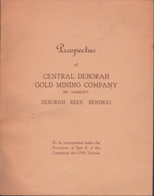
Document - MCCOLL, RANKIN AND STANISTREET COLLECTION: CENTRAL DEBORAH GOLD MINE NL: PROSPECTUS, 1939
Document: McColl, Rankin & Stanistreet Collection: Central Deborah Gold Mine NL - 4 copies of prospectus. Buff covered booklet. Written on front ' Prospectus of Central Deborah Gold Mining Company No Liability Deborah Reef, Bendigo. To be incorporated under the Provisions of Part II of the companies Act 1938. Victoria.' Details capital, proposed directors and manager. Contains map of Central and North Deborah mines and Monument Hill.organization, business, central deborah gold mine, mccoll, rankin & stanistreet collection: central deborah gold mine nl. gold mining -
Bendigo Historical Society Inc.
Map - MUSKERRY, 23/01/1888
... Inc. History House 11 Mackenzie Street Bendigo goldfields MAP ...Map: Muskerry , County of Rodney. Parish plan. ( number 251 in Map Cupboard 1)map, rodney, parish plan, muskerry -
 Bendigo Historical Society Inc.
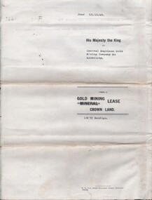
Document - MCCOLL, RANKIN AND STANISTREET COLLECTION: CENTRAL NAPOLEON GOLD MINING CO. N.L, 16th April 1951
Document: Letter to the Central Napoleon Gold Mining Co N.L from McColl Rankin & Stanistreet notifying the company that Mr J.Bakker's land application no 94/152 has been approved, marked in grey pencil on map located in document 2205.706a.organization, business, industrial - mining, mccoll rankin & stanistreet, mining, gold mining, central napoleon -
 Bendigo Historical Society Inc.
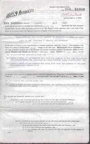
Document - MCCOLL, RANKIN AND STANISTREET COLLECTION: CENTRAL NAPOLEON GOLD MINING CO. N.L, 15th August 1950
Document: Gold Mining Lease Crown Land No 11272 Bendigo, entered in the register book Vol 331 Fol 36450, embossed seals of Central Napoleon Gold Mining Co N.L & King George VI, Map: No 11272 Mining District of Bendigo, Parish of Sandhurst, County of Bendigo, shows the minerunning between Harvey & Inglis Streets and crossing Empire and Sparrowhawk Roads and running a good distance beyond Sparrowhawk Rd.organization, business, industrial - mining, mccoll rankin & stanistreet, mining, gold mining, central napoleon -
 Bendigo Historical Society Inc.
Document - MCCOLL, RANKIN AND STANISTREET COLLECTION: NORTH VIRGINIA GOLD MINING COMPANY NL, INDENTURE, 1936
McColl Rankin & Stanistreet, North Virginia Gold Mining Company NL, a/ Indenture operating on operations in the Parishes of Nerring and Sandhurst. Hold crown land for the tern of 13 years and 53 days expiring on July 27, 1949. Map glued to page 5 runs from Hodgson Street to Orlando St and covers Newton, Reef, Fry & Leslie Street and Sailors Gully Road I the Parish of Sandhurst. Dated: 4/6/1936. Signatures: W Daly and ? Mining lease number 10859 Bendigo, b/ Indenture, North Virginia Gold Mining Company NL. Signed: J B ?, A Mackay & ? Dated: 8/1/1940. c/ Indenture, North Virginia Gold Mining Company NL. 960 still owing by the company, the company has applied to the minister to advance the company the further sum of 500 pounds which the minister consented to. Signed: J ?, A Mackay & Stanistreet?cottage, miners, mccoll rankin & stanistreet north virginia gold mining company nl indenture 1949 lease 10859 -
Bendigo Historical Society Inc.
Map - PARISH OF DIGGORRA, 23/02/1911
... Inc. History House 11 Mackenzie Street Bendigo goldfields MAP ...Map: Parish of Diggorra, County of Bendigo. Parish plan ( number 247 in Map Cupboard 1)map, bendigo, parish plan, diggorra -
Bendigo Historical Society Inc.
Map - PARISH OF EGERTON, 19/03/1894
... Inc. History House 11 Mackenzie Street Bendigo goldfields MAP ...Map: Parish of Egerton, Settlement on Lands Act 1893, County of Bendigo. Parish plan ( number 245 in Map Cupboard 1)map, bendigo, settlement on lands act 1893, egerton, settlement on lands act 1893.