Showing 3220 items
matching road map
-
 Whitehorse Historical Society Inc.
Document, Map of Vermont & Mitcham
... heatherdale road canterbury road vermont mitcham road Copy of map ...Copy of map showing land in Mitcham and Vermont areasCopy of map showing land in Mitcham and Vermont areas bounded by Whitehorse , Mitcham, Canterbury and Heatherdale roads.Copy of map showing land in Mitcham and Vermont areasland subdivision, whitehorse road, mitcham, heatherdale road, canterbury road, vermont, mitcham road -
 Whitehorse Historical Society Inc.
Pamphlet, Schwerkolt Cottage Mitcham
A pamphlet issued by City of NunawadingA pamphlet issued by City of Nunawading on Schwerkolt Cottage with photographs and location map.A pamphlet issued by City of Nunawading schwerkolt cottage, city of nunawading -
 Whitehorse Historical Society Inc.
Document - Leaflet, Blackburn Land Sale, 19/11/1910 12:00:00 AM
Pamphlets showing sale of land Gardenia Street, Blackburn and surrounding streets.Pamphlets showing sale of land Gardenia Street, Blackburn and surrounding streets. Schedule of prices. Hand drawn mapPamphlets showing sale of land Gardenia Street, Blackburn and surrounding streets.blackburn township estate co. ltd., blackburn railway station, south parade blackburn, laburnum street, blackburn, the avenue blackburn, fuschia street blackburn, linum street blackburn, main street, t.r.b.morton. & son, land subdivision -
Whitehorse Historical Society Inc.
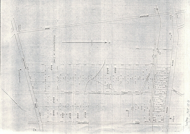
Map, Austral Park, Mitcham, 1907
Advertisement for subdivision of area south of Mitcham Railway Station.Advertisement for subdivision of area south of Mitcham Railway Station. Includes area now site of Mitcham reservoir. Some details of main buildings in Mitcham and Vermont.Advertisement for subdivision of area south of Mitcham Railway Station. land subdivision, mitcham, mitcham road, mitcham, calcutta street, mitcham, delhi street, mitcham, meerut street, mitcham, simla street, mitcham, agra street, mitcham, lucknow street, mitcham, mitcham reservoir, austral park mitcham -
Whitehorse Historical Society Inc.
Map, Applied for the Roman Catholic Church, 1848
Photocopy of manuscript map inscribed 'Reserve 40 Parish of Nunawading'.Photocopy of manuscript map inscribed 'Reserve 40 Parish of Nunawading'. Streets not named. Note on verso: Site reserved for Roman Catholic Church in Nunawading c1848 (Cr Riversdale and Warrigal Roads)Photocopy of manuscript map inscribed 'Reserve 40 Parish of Nunawading'. churches, catholic church, riversdale road, surrey hills, warrigal road, surrey hills -
Whitehorse Historical Society Inc.
Map, Plan of the Parish of Nunawading, 1853
Photocopy of map showing names of selectors, also list of references to the corners of allotments.Photocopy of map showing names of selectors, also list of references to the corners of allotments. Note on verso:'Gardiners Creek, Ballyshanassey township surveyed by H. Parmein, Surveyor General's Office Nov 30, 1853 also Reference to the Corners of allotments' (Plan 428)Photocopy of map showing names of selectors, also list of references to the corners of allotments. land subdivision, gardiners creek, ballyshanassy, parmein, h, burwood east, maps -
Whitehorse Historical Society Inc.
Map, Site for Wesleyan Church, Nunawading, 1855
... Elgar Road Burwood Maps Photocopy of manuscript map showing ...Photocopy of manuscript map showing names of landholders.Photocopy of manuscript map showing names of landholders. Note on verso: Plan of allotments in the City of Melbourne appropriated to the Wesleyans. Site for Wesleyan Church, Nunawading 1848 (Corner of Burwood and Elgar Roads - S of Burwood, W of Elgar)Photocopy of manuscript map showing names of landholders. churches, wesleyan church, burwood, burwood road, burwood, elgar road, burwood, maps -
Whitehorse Historical Society Inc.
Map, The Parish of Nunawading, 1853
Photocopy of manuscript plan with allotments numbered and some named.Photocopy of manuscript plan with allotments numbered and some named. Note on verso: The Parish of Nunawading in the County of Bourke; lithographed at the Surveyor General's office by J.Jones Jan 18th 1853. Endorsed Sale Plan 271. Dray tracks, water holes and terrain indicated.Photocopy of manuscript plan with allotments numbered and some named. land subdivision, maps, parish of nunawading, jones, j -
Whitehorse Historical Society Inc.
Map, Parish of Nunawading, 1853
Photocopy of manuscript map with allotments numbered and named.Photocopy of manuscript map with allotments numbered and named. Note on verso: Parish of Nunawading, County of Bourke. Gardiners Creek, Ballyshanassey Township, surveyed by H. Parmein, Surveyor General's office, Nov 30th 1853 [enlargement of ND2801, no list of corner references]Photocopy of manuscript map with allotments numbered and named. maps, gardiners creek, ballyshanassy, burwood east, parmein, h -
Whitehorse Historical Society Inc.
Map, Boroondara, Nunawading, 1853
Map of section of Parishes of Boroondara and NunawadingMap of section of Parishes of Boroondara and Nunawading with allotments numbered and named. Note on verso: Boroondara and Nunawading c1853.Map of section of Parishes of Boroondara and Nunawading maps, parish of nunawading, parish of boroondara -
Whitehorse Historical Society Inc.
Map, Parish of Boroondara and Parish of Nunawading, 1850
Photocopy of manuscript map.Photocopy of manuscript map. Note on verso: Plan of 22 portions marked in the Parish of Boroondara and 6 portions in the Parish of Nunawading c1850Photocopy of manuscript map. maps, parish of boroondara, parish of nunawading -
Whitehorse Historical Society Inc.
Map, Parishes of Bulleen, Boroondara, Prahran and Nunawading, 1850
Photocopy of map and tables of corners of allotments.Photocopy of map and tables of corners of allotments. Note on verso: Nunawading, Boroondara, Prahran. Allotments in the Parish surveyed by Lindsay Clarke 1850 (note by Robert Hoddle, surveys by Unwin, Elgar and Dendy indicated)Photocopy of map and tables of corners of allotments. maps, parish of bulleen, parish of boroondara, parish of prahran, parish of nunawading, clarke, lindsay, hoddle, robert -
Whitehorse Historical Society Inc.
Map, Plan of special survey selected by H. Elgar Esq, 1841
Photocopy of plan and listing of corner stakes.Photocopy of plan and listing of corner stakes. Note on verso: Plan of special survey selected by H. Elgar Esq in the Parishes of Boroondara and Nunawading, County of Bourke. Surveyed by T.H. Nott (?Sydney) 31 May 1841. Boroondara Special Survey B.17, with attached descriptive note by T. H. Nott.Photocopy of plan and listing of corner stakes. maps, parish of boroondara, parish of nunawading, elgar, h, nott, t.h. -
Whitehorse Historical Society Inc.
Map, The Mascot Estate, Blackburn, 1924
Advertisement for auction of land between the railway line and Whitehorse Road in Blackburn.Advertisement for auction of land between the railway line and Whitehorse Road in Blackburn. Includes photos of houses in the neighbourhood. Auction by H. Pallyn & Co and Frank Fisher in conjunction. Street names have changed to Ceylon Street and Terracotta Drive.Advertisement for auction of land between the railway line and Whitehorse Road in Blackburn. land subdivision, whitehorse road, blackburn, simla street, mitcham, king street, blackburn, iona street, blackburn, ceylon street, blackburn, terracotta drive, blackburn, mascot estate, blackburn -
Whitehorse Historical Society Inc.
Map, Shire of Boroondara, Parish of Nunawading, 1904
... of printed map extending from Camberwell to Middleborough Road ...Photocopy of printed map extending from Camberwell to Middleborough Road.Photocopy of printed map extending from Camberwell to Middleborough Road. note on verso: From a book of maps dated 1904.Photocopy of printed map extending from Camberwell to Middleborough Road. maps, shire of boroondara, parish of nunawading -
Whitehorse Historical Society Inc.
Map, Parish of Nunawading, 1927
Map of the Parish together with part of the Borough of Box Hill.Map of the Parish together with part of the Borough of Box Hill. Includes names of lease or license holders, sizes of leases and in some areas dates of leases. Roads, railway and stations marked. Original survey by W.J.Busocon, 1915. Manuscript note: 15.2.1927 Verified Dept. Lands and Survey.Map of the Parish together with part of the Borough of Box Hill. maps, parish of nunawading, borough of box hill -
Whitehorse Historical Society Inc.
Map, Directory Maps of the County of Bourke, 1892
Copies of Directory maps:(i) Title Page, (ii) Preface (iii) Heading section of Map of Melbourne and Suburbs (iv) Parish of Bulleen - includes 'North - East portion of the Parish of Nunawading (v) Village of Burwood. Note: 107(a), 107(b), 107(c) are copies of the same set of sheets.Copies of:(i) Title Page, (ii) Preface (iii) Heading section of Map of Melbourne and Suburbs (iv) Parish of Bulleen - includes 'North - East portion of the Parish of Nunawading (v) Village of Burwood. Note: 107(a), 107(b), 107(c) are copies of the same set of sheets.Copies of Directory maps:(i) Title Page, (ii) Preface (iii) Heading section of Map of Melbourne and Suburbs (iv) Parish of Bulleen - includes 'North - East portion of the Parish of Nunawading (v) Village of Burwood. Note: 107(a), 107(b), 107(c) are copies of the same set of sheets.maps, parish of bulleen, parish of nunawading, burwood -
Whitehorse Historical Society Inc.
Map, Parish of Bulleen, 1892
Copy of map of the Parish of BulleenCopy of map of the Parish of Bulleen together with North-East portion of the Parish of Nunawading.Copy of map of the Parish of Bulleenmaps, parish of bulleen, parish of nunawading -
Whitehorse Historical Society Inc.
Map, Subdivision of Allotment 122a, 1972
Subdivision of land along Livermore Close and Moore Road, Vermont South.Subdivision of land along Livermore Close and Moore Road, Vermont South. Original survey Rob Poole 1899. Stamp indicates 'Land on this plan is in proclaimed survey No 21. Survey Coordination Act 1940. As from 9 Aug 1972. Two maps in different scales.Subdivision of land along Livermore Close and Moore Road, Vermont South. land subdivision, livermore close, vermont south, moore road, vermont south, dandenong creek -
Whitehorse Historical Society Inc.
Map, Nunawading Planning Scheme, 7/06/1994 12:00:00 AM
Local Section maps 1 - 4 with index. Geographical information system land Information Branch. Scale 1:10,000 Shows zoning under planning scheme.Local Section maps 1 - 4 with index. Geographical information system land Information Branch. Scale 1:10,000 Shows zoning under planning scheme.Local Section maps 1 - 4 with index. Geographical information system land Information Branch. Scale 1:10,000 Shows zoning under planning scheme.blackburn, blackburn north, blackburn south, forest hill, heatherdale, maps, nunawading, vermont, vermont south, town planning, burwood east, laburnum -
Whitehorse Historical Society Inc.
Map, Aston, 1989
Map of the Commonwealth Electoral Division of Aston. Scale 1:25,000Map of the Commonwealth Electoral Division of Aston. Scale 1:25,000Map of the Commonwealth Electoral Division of Aston. Scale 1:25,000electoral boundaries, aston (commonwealth electoral division) -
 Whitehorse Historical Society Inc.
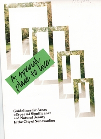
Pamphlet, A Special place to live, 1985 (addendum 1988)
A publication of the City of NunawadingA publication of the City of Nunawading explaining the regulations applying to the Special Residential (Nunawading) Zone No 5. The regulations cover proportions of land which may be built on and identifies trees which must be preserved. An addendum issued in 1988 includes a map of the area and identifies National Trust classified streets in Blackburn and the buffer areas in which less stringent regulations apply.A publication of the City of Nunawadingcity of nunawading, national trust of australia (victoria), special residential (nunawading) zone no. 5, jeffery street, blackburn, laurel grove, linum street, boongarry avenue, hill street, land use, by-laws, town planning, acacia avenue, waratah crescent -
Whitehorse Historical Society Inc.
Letter - Correspondence, Mullum Mullum Creek
... Whitehorse Historical Society Inc. 2-10 Deep Creek Road ...Letter to the Minister of Land & Works from Richard R. Cross, George Hislop, Neil Faconer (sic) and Robert Leith .Letter to the Minister of Land & Works from Richard R. Cross, George Hislop, Neil Faconer (sic) and Robert Leith regarding a track through Crown Lands which has been applied for by Messrs. Logan and Galbraith. With map.Letter to the Minister of Land & Works from Richard R. Cross, George Hislop, Neil Faconer (sic) and Robert Leith .mullum mullum creek, roads and streets, cross, richard r., hislop, george, falconer, neil, leith, robert, warrandyte mitcham track, logan, galbraith -
Whitehorse Historical Society Inc.
Document, Eastern Corridor Road Development, 1/11/1986 12:00:00 AM
... Collection of maps showing Eastern Corridor Road... for public display. Collection of maps showing Eastern Corridor Road ...Collection of maps showing Eastern Corridor Road Development and traffic volume for public display.Collection of maps showing Eastern Corridor Road Development and traffic volume for public display.Collection of maps showing Eastern Corridor Road Development and traffic volume for public display.freeways, ecord study team -
Whitehorse Historical Society Inc.
Map, Eastern Freeway, n.d
Map of proposed Eastern Freeway, Mitcham - Ringwood.Map of proposed Eastern Freeway, Mitcham - Ringwood.Map of proposed Eastern Freeway, Mitcham - Ringwood.freeways, eastern freeway, mullum mullum creek -
Whitehorse Historical Society Inc.
Map, Bike Paths, 1995
Map in Boroondara Bulletin showing Bike paths in the City of Boroondara.Map in Boroondara Bulletin showing Bike paths in the City of Boroondara.Map in Boroondara Bulletin showing Bike paths in the City of Boroondara.bicycle paths, city of boroondara -
Whitehorse Historical Society Inc.
Pamphlet, Koori Sites, 1/04/1999 12:00:00 AM
Brochure with map showing Koori sites in the City of Whitehorse and giving a brief history of aborigines in area.Brochure with map showing Koori sites in the City of Whitehorse and giving a brief history of aborigines in area.Brochure with map showing Koori sites in the City of Whitehorse and giving a brief history of aborigines in area.aborigines, sacred sites, city of whitehorse, archaeological sites, aboriginal artefacts, wurundjeri-willam tribe -
Whitehorse Historical Society Inc.
Map, Elmore Houses, 1/08/1993 12:00:00 AM
Elmore Houses - Blackburn Lake Walk [map by] Ken Green. August 1993.Elmore Houses - Blackburn Lake Walk [map by] Ken Green. August 1993.Elmore Houses - Blackburn Lake Walk [map by] Ken Green. August 1993.blackburn, green, ken, elmore houses, elmore, algernon john -
 Whitehorse Historical Society Inc.
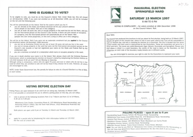
Pamphlet, Inaugural Election Springfield Ward, 1/03/1997
Notice to electors of Springfield Ward. Includes map of city with wards defined. List of polling places.Notice to electors of Springfield Ward. Includes map of city with wards defined. List of polling places. Photographs and statements by candidates. Eligibility of voters and conditions for voting, including index of streets, primary vote report, how to vote card..Notice to electors of Springfield Ward. Includes map of city with wards defined. List of polling places. city of whitehorse, local government elections, moore, nick, branagan, wendy, abbott, kevin, dunn, allan, peter, yao, colin -
Whitehorse Historical Society Inc.
Document, Box Hill History Kit
Box Hill History Kit published by Box Hill Historical Society and Box Hill City Council.Box Hill History Kit published by Box Hill Historical Society and Box Hill City Council. Contents include Brochures, First Box Hill Railway Time Table, copies of Box Hill & Doncaster Tramway Tram and old photos taken around Box Hill, Tom Roberts Artists' Camp, 1905 Map of Box Hill etc.Box Hill History Kit published by Box Hill Historical Society and Box Hill City Council. box hill historical society, box hill city council