Showing 110054 items matching "roads"
-
 Whitehorse Historical Society Inc.
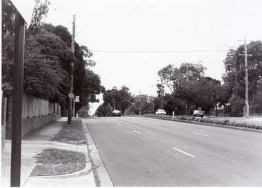
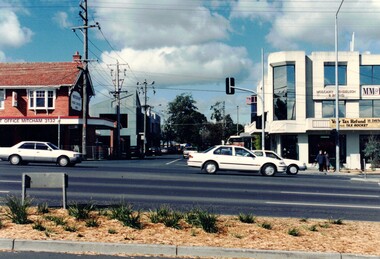
Photograph, Canterbury Road, Blackburn, 6/01/2001 12:00:00 AM
Black and white photograph of Canterbury Road Blackburn looking east from Blackburn Road.canterbury road, blackburn., blackburn road -
 Whitehorse Historical Society Inc.
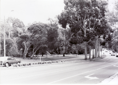
Photograph, Blackburn Road, Blackburn, 6/01/2001 12:00:00 AM
Black and white photograph of Blackburn Road Blackburn looking north from Canterbury Road.blackburn road, blackburn., canterbury road -
 Whitehorse Historical Society Inc.
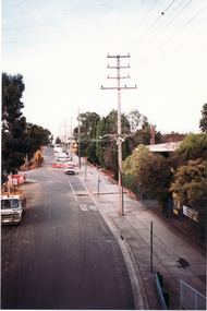
Photograph, Footbridge Whitehorse Road, 1/06/1999 12:00:00 AM
Coloured photo - From Footbridge in Whitehorse Road, Mitcham, looking towards Mitcham Road.whitehorse road, overhead powerlines -
 Whitehorse Historical Society Inc.
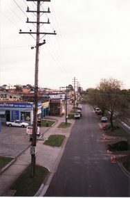
Photograph, Whitehorse Road Footbridge, 1/06/1999 12:00:00 AM
Coloured photo - From Whitehorse Road Footbridge in Mitcham, looking towards Rooks Road.whitehorse road, overhead powerlines -
 Whitehorse Historical Society Inc.
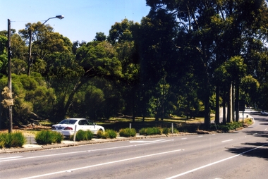
Photograph, Blackburn Road, South Blackburn, 2012
See NP4006Coloured photograph of Blackburn Road heading north from Canterbury Road toward Blackburnblackburn road, blackburn south, canterbury road blackburn south -
 Whitehorse Historical Society Inc.
Photograph, Station Street Mitcham
Coloured photograph of Station Street Mitcham looking South. Main road is Whitehorse Roadstation street mitcham, streets -
 Ringwood and District Historical Society
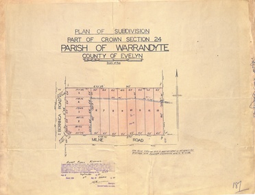
Map - Plan of Subdivision, Part of Crown Section 24, Parish of Warrandyte, County of Evelyn - 1951
Survey map of residential allotments in Berringa Road and Milne Road, Park Orchards, Victoria. Russell Francis Kinnane, Licensed Surveyor, 4th October, 1951. -
 Canterbury History Group
Photograph - Outside street view of No.88 Maling Road, Jan Pigot, 27/03/1993 12:00:00 AM
Coloured photograph for the front windows and door of the Maling Road Patisserie at No. 88 Maling Road.canterbury, maling road, shops -
Canterbury History Group
Photograph - View inside shop at No.88 Maling Road, Jan Pigot, 27/03/1993 12:00:00 AM
Coloured photograph of the inside food cabinets of the Maling Road Patisserie at No. 88 Maling Roadcanterbury, maling road, shops, shop interiors -
Canterbury History Group
Photograph - Street view of building at No. 111 Maling Road, Jan Pigot, 27/03/1993 12:00:00 AM
Coloured photograph of of the building on the corner of Maling Road and Theatre Place at No. 111 Maling Roadcanterbury, maling road, shops, street signs -
 City of Moorabbin Historical Society (Operating the Box Cottage Museum)
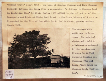
Document - Photograph, photocopy, of ‘Spring Grove’ 19th C house, Charman Road, Cheltenham, c1979
In 1852 Stephen Charman purchased 160 acres bounded by Charman Rd and Balcombe Road in an area called Spring Grove , later Cheltenham. A spring ran through the land providing a good source of water. Stephen aged 21 years had arrived in Melbourne 1842 as one of Henry Dendy’s emigrants . His Ship passage was paid by the Colonial Land and Emigration Commission and in return he was required to work on the land of the Henry Dendy Special Survey Brighton 1841. However Henry Dendy could not provide enough work for all the emigrants that arrived and Stephen had to obtain other work. Then sadly his young wife Harriett and their infant died. 1850 Stephen married widow Mary Gettens, a Publican in Little Collins Street, with 5 children. Stephen & Mary built a wattle and daub hut and established a market garden producing marigolds for Martin & Pleasance Pharmacists, Melbourne. They had 7 more children and built a weatherboard cottage that was used for early Methodist Church services. Stephen donated 1 acre to the Methodist Church in 1855 for Chapel , School and Cemetery. This is the weatherboard cottage in the photocopy showing the building extension, The road between Cheltenham and Mentone bears their name. Mary died in 1870 and Stephen remarried 1878 and died in Gippsland 1906. The original Photograph is endorsed by Francis Marie Ward , formerly Hopkins nee Charman who was the grandmother of Mr A.L Jones A photocopy of a black and white photograph of ‘Spring Grove’ , that was the first house in Charman Road , Cheltenham c1852 , showing later extensions. spring grove cottage 1852, schumer l, cheltenham, charman stephen, early settlers, jones a l, gettens mary, rees mary, charman mary, moorabbin, brighton, henry dendy special survey 1841, ward frances marie, charman frances marie -
 Eltham District Historical Society Inc
Slide, View of Thomas Street from intersection with Frank Street, Eltham, Nov. 1981
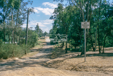
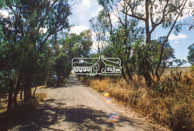
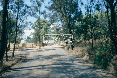
... roads ...Roll of film taken by Eltham Shire Council officers (Nov. 1981) of the Beard street group, a private street scheme, before construction commenced in February 1982. They provide perspective of the changes in housing styles and road development that began sweeping in from the mid 1970s with increasing urbanisation of what was once more outlying suburbs and regions.35 mm colour positive transparency (1 of 27) Mount - Kodak Ektachrome CardProcessed 18 Jan 1982roads, housing estate, infrastructure, private street scheme, eltham, frank street, thomas street -
 Eltham District Historical Society Inc
Slide, Frank Street, Eltham, Nov. 1981
... roads ...Roll of film taken by Eltham Shire Council officers (Nov. 1981) of the Beard street group, a private street scheme, before construction commenced in February 1982. They provide perspective of the changes in housing styles and road development that began sweeping in from the mid 1970s with increasing urbanisation of what was once more outlying suburbs and regions.35 mm colour positive transparency (1 of 27) Mount - Kodak Ektachrome CardProcessed 18 Jan 1982eltham, housing estate, infrastructure, private street scheme, roads, andrews street, frank street -
 Eltham District Historical Society Inc
Slide, Beard Street, Eltham, Nov. 1981
... roads ...Roll of film taken by Eltham Shire Council officers (Nov. 1981) of the Beard street group, a private street scheme, before construction commenced in February 1982. They provide perspective of the changes in housing styles and road development that began sweeping in from the mid 1970s with increasing urbanisation of what was once more outlying suburbs and regions.35 mm colour positive transparency (1 of 27) Mount - Kodak Ektachrome CardProcessed 18 Jan 1982roads, housing estate, infrastructure, private street scheme, beard street, frank street, shalbury avenue -
 Kew Historical Society Inc
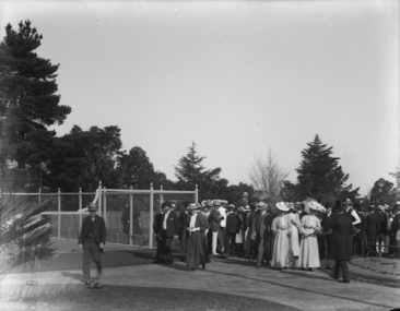
Photograph - 'After the First Bowl', Auburn Heights Bowling Club, 1906
Sir John Madden, Chief Justice of Victoria, opened the Auburn Heights Recreation Club in Barkers Road in December 1904. Two years later the greens were improved and a new croquet lawn established. In September 1906, a ceremony was held to open these and also the new pavilion designed by Harry Tompkins.Early glass plate negative representing the opening of an important sporting facility in Kew in 19061/4 plate glass negative (and accompanying print) of after the 'first bowl' on the improved greens at the Auburn Heights Recreation Club in Barkers Road, Kew. The event occurred in 1906.auburne heights recreation club, cotham road, kew, sir john madden, harry tompkins -
Whitehorse Historical Society Inc.
Document, Nunawading and District local government records
Records of the municipalities of Nunawading and Box Hill districtsRecords of the municipalities of Nunawading and Box Hill districts from Road District 1857 through to City of Nunawading 1994 and lists of location of records for each period within the Public Record Office. Extracts from PRO lists of holdings.Records of the municipalities of Nunawading and Box Hill districts local government, nunawading road district, shire of nunawading, borough of box hill, city of box hill, shire of blackburn and mitcham, city of nunawading, victoria. public record office -
 Orbost & District Historical Society
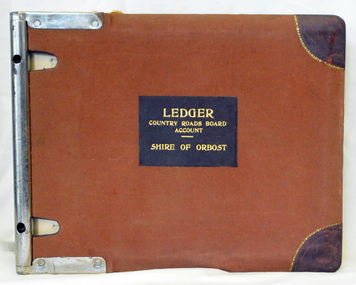
ledger, 1950's -1960's
This ledger was used bt the Shire of Orbost local government to record Country Roads Board accounts 1950's and 1960's. The item was donated to Orbost & District Historical society from P.R.O.V. as a Place of Deposit (POD) item for safe keeping by a local history group or museum. The shire covered an area of 9,347 square kilometres and existed from 1892 until 1994 when it became part of the East Gippsland Shire Council. Orbost was at first included in the Bairnsdale Shire from 1882 and was later part of the Tambo Shire. Because of travelling distances the Croajingalong Shire was created in 1892 (name changed to Orbost Shire 17.2.1893 with James Cameron as the first Shire President. In 1994 it amalgamated to become part of East Gippsland Shire Council. The Country Roads Board was the government authority for the construction and maintenance of main roads in Victoria between 1913 and 1983. It was succeeded by the Road Construction authority on 1 July 1983 and later merged with the Road Traffic Authority on July 1 1989 to form the Roads Corporation. James Cameron, an Orbost farming pioneer and Member of the Legislative Assembly, fathered the Country Roads Board. This ledger is a hand-written record of accounts for the Orbost Shire local council. It pre-dates computer records. The Orbost Shire Council no longer exists having been absorbed into the East Gippsland Shire Council.A heavy brown coloured ledger with covered wooden covers. it has steel metal binding. Inside are strips of paper marking pages. It contains blue ink hand-written records of monies in/out (?) to Shire of Orbost Council. On the front cover inside a black rectangle in gold print is " LEDGER COUNTRY ROADS BOARD ACCOUNT ORBOST". It is an "Emu Binder".ledger orbost-shire accounts country-roads-board -
 Phillip Island and District Historical Society Inc.
Photographs, c 1900
Four photograph enlargements from John Jansson's collection. Farm work on three properties: Underdown's farm, Rhyll; Harbison's - wool being carted for shipment to Melbourne by Ketch from Cowes Jetty; McIlwraith's farm harvesting hay at their property called "Heath Hill" at Rhyll.Four enlargements of original photographs and postcards mounted on cardboard for display purposes. 292-01 Norm Smith with a four horse team preparing ground for Chicory. 292-02. Wool Team on road to Cowes 292-03. Horse and dray loaded with stacks of hay - workers in background at McIlwraith's farm "Heath Hill", Rhyll 292-04. Horse and dray with family including ladies and children.292-02. Many Happy Returns. Good Luck. Phillip island - Wool Team on road to Cowes. 292-03. Harvest time on Phillip Island. Victoria underdown, harbison, mcilwraith, heath hill, chicory farming, wool carting, john jansson -
 Surrey Hills Historical Society Collection
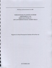
Book, Boroondara Planning Scheme Amendment C116 Heritage Overlay - 629 Canterbury Road, Surrey Hills, Oct-11
Report of a panel pursuant to Section 153 of the Planning and Environment Act regarding the property at 629 Canterbury Road, Surrey Hills - an Edwardian two story red-brick butchers' shop built in 1897 for the Tacey family.Report of a panel pursuant to Section 153 of the Planning and Environment Act regarding the property at 629 Canterbury Road, Surrey Hills - an Edwardian two story red-brick butchers' shop built in 1897 for the Tacey family.abermore pty ltd, heritage studies, tacey family butchers, surrey hills, canterbury road, (ms) natica schmeder, sherry james, jo james, (mr) mark marsden, (mr) bryce raworth, 2011, 1897 -
Whitehorse Historical Society Inc.
Article, School Kids Go 'Green', 22/09/1993 12:00:00 AM
Primary School children plant trees along Melbourne Water Pipetrack in Forest Hills.Primary School children plant trees along Melbourne Water Pipetrack in Forest Hills. Final part of Melbourne Water's revegetation of 5 K section of Pipetrack between Springvale Road and Burwood Highway, involving Community Groups, incl. photo.Primary School children plant trees along Melbourne Water Pipetrack in Forest Hills. melbourne water, community groups, primary schools, bowden, cliff, torres, norman, jackson, katherine -
 Whitehorse Historical Society Inc.
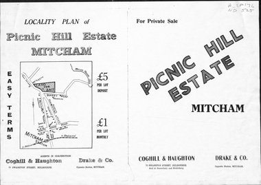
Pamphlet, Picnic Hill Estate, Mitcham, n.d
Photocopy of pamphlet, locality map and plan of 40 home sites on Picnic Hill estate extending from Quarry Road, Mitcham Road and McKeon Road, Mitchamland subdivision, mitcham road, mitcham, quarry road, mckeon road, wooddale grove, rotherwood avenue, cobham road -
Whitehorse Historical Society Inc.
Map, Burwood Road, Box Hill City, 1952
Country Roads Board survey of Burwood Road, Burwood between Central Avenue and Elgar Road. Includes details of fencing, nature of buildings. With penciled additions to 1957.Country Roads Board survey of Burwood Road, Burwood between Central Avenue and Elgar Road. Includes details of fencing, nature of buildings. With penciled additions to 1957.Country Roads Board survey of Burwood Road, Burwood between Central Avenue and Elgar Road. Includes details of fencing, nature of buildings. With penciled additions to 1957.maps, burwood road, burwood, parer street, elgar road, cromwell street, ireland street, central avenue burwood, scott grove, somers street, gilmour street, evans street, edwards street, mills road -
 Whitehorse Historical Society Inc.
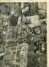
Map, Photo-map Ringwood A4A, 1945
Aerial photo covering approximately from Box Hill to Mitcham (West to East) and Springfield Road to Hawthorn Road (North to south).Aerial photo covering approximately from Box Hill to Mitcham (West to East) and Springfield Road to Hawthorn Road (North to south). Names of main roads inscribed.Aerial photo covering approximately from Box Hill to Mitcham (West to East) and Springfield Road to Hawthorn Road (North to south).aerial photographs, box hill, blackburn, nunawading, forest hill, mitcham -
 Southern Sherbrooke Historical Society Inc.
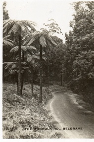
Postcard, The Monbulk Rd, Belgrave
Sepia-toned postcard featuring Monbulk Road, Belgrave, presumably heading towards Kallista. Very tall fern trees on left side of road. Road not made. -
 Ringwood and District Historical Society
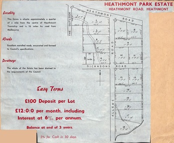
Document, Plan of Subdivision - Heathmont Park Estate (undated, circa 1949)
Land sale brochure clipping with map showing layout and sizes of 18 residential allotments in The Outlook, Heathmont Road, Allens Road and Dickasons Road, Heathmont, Victoria.Easy terms. £100 deposit per lot. £12:0:0 per month including interest at 6% per annum. Balance at end of 3 years. 5% for cash in 30 days. -
 Eltham District Historical Society Inc
Photograph, Research Shops precinct
Two colour photographs in the vicinity of Research Shops: 1. At Main Road and Warrandyte Road roundabout looking south east towards the shops 2. At the north end of the shops at intersection of Raglan Road and Main Road looking north eastmain road, research, ingrams road, shops, roundabouts -
 Bendigo Historical Society Inc.
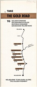
Document - AULSEBROOK COLLECTION: THE GOLDEN ROAD PRMOTIONAL BOOKLET
Aulsebrook Collection: The Gold Road Promtional Booklet -Brochure fold out booklet promoting The Gold Road, a tourist road for tourists to camp, see historical sites, landmarks and natural interests etc. -Various images relating to The Gold Road -
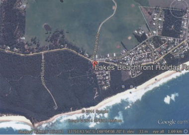 Lakes Entrance Historical Society
Photograph - Lake Tyers Beach, Google Earth, 2014
Colour photograph of Lakes Beachfront Holiday Resort showing Lake Tyers Beach Road, Barracouta Road and Salmon Road, walking track with ocean beach on Bass Strait in background, Bream Road in foreground, Lake Tyers Beach VictoriaLakes Beachfront Holiday Reocean, caravan parks -
Whitehorse Historical Society Inc.
Article, George was much loved, 1950's
An article about George Taylor of Mitcham, who died 1957.An article about George Taylor of Mitcham, who died 1957. He delivered things by horse and cart, usually on roads impassable to vehicles. He saved the last horse trough in Mitcham by parking his horse & cart in front of it daily.An article about George Taylor of Mitcham, who died 1957. taylor, george -
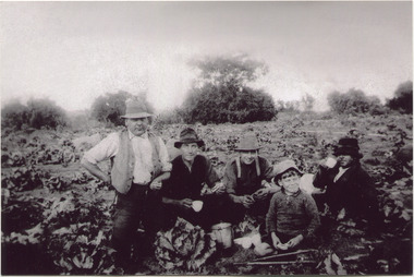 City of Moorabbin Historical Society (Operating the Box Cottage Museum)
Photograph, Black & White, V Peterson E Boundary Rd E Bentleigh market garden c1925, Original c1925
The Peterson family were early settlers in Moorabbin Shire and established a market garden in East Boundary Road East Bentleigh. Vic Peterson - waistcoat, with Dick Marriott seated - ( brother in -law ), 2 unknown men and 7year old Geoff Peterson - Poliomyelitis as a baby- sitting in front with his walking sticks. The crop is cabbages that would be harvested and sent to the Melbourne markets.The early settlers like the Petersons and Marriotts, in the Parish of Moorabbin County of Bourke after Henry Dendy's Special Survey Brighton 1841, established market gardens, fruit & flower gardens, poultry & dairy farms, vineyards as well as shop businesses, blacksmiths, chemists, nursing homes and schools & Churches.Black & White photograph of Vic Peterson and 3 men & boy on his market garden in East Boundary Road East Bentleigh c1925 re-digitised 2005back ; handwritten information unsignedwagons, vulcan trucks, draught horses,, peterson vic, marriott dick, cabbage crops, vegetable crops, poliomyelitis epidemics 20thc , elster creek, plateways moorabbin shire, smith j l; smith mary ann, stanley helen, smith vic, smith harry redvers, chaff cutter, horse drawn carts, toll gates brighton, motor cars 1900, steam engines, early settlers, bentleigh, mckinnon, parish of moorabbin, city of moorabbin, county of bourke, moorabbin roads board, shire of moorabbin, henry dendy's special survey 1841, were j.b.; bent thomas, o'shannassy john, king richard, charman stephen, highett william, ormond francis, maynard dennis, market gardeners, vineyards, orchards