Showing 38591 items matching "2016-10-15"
-
 Bendigo Historical Society Inc.
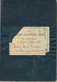
Document - COHN BROTHERS COLLECTION: BANK BOOK, 31/10/1887 to 1/2/1888
Document. Cohn Bros. Collection. Dark blue/grey cloth covered bank book. The London Chartered Bank of Australia in Account current with Cohn Bros. Victoria. Brewing & Malting Co. Ltd. White card in the book - Carlton & United Breweries Limited. Re - Meeting of the Board. Dated 30 November, 1964 to L. R. Cohn, Esq.organization, business, cohn bros, cohn bros. collection, the london chartered bank of australia, brewers, cordial & aerated water manufacturers -
 Bendigo Historical Society Inc.
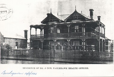
Photograph - HARRY BIGGS COLLECTION: CARADON EAGLEHAWK, 10/09/1901
Photograph of 'Caradon', Victoria Street Eaglehawk. This was the home of Richard Jones, an Eaglehawk Physician and later by James Deane, another Physician. The property was next acquired by John Hooper, a prominent mining managerbuildings, house, caradon, caradon, richard jones, james deane, john hooper, eaglehawk -
 Bendigo Historical Society Inc.
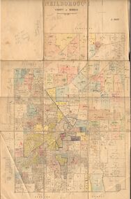
Map - JACK FLYNN COLLECTION: NEILBOROUGH, 13/10/1927
Map: Parish of Neilborough, County of Bendigo. Parish plan.Photo Lithographed at the Department of Lands and Survey, Melbourne by W.J. Butsonmap, bendigo, parish plan, neilborough -
 Bendigo Historical Society Inc.
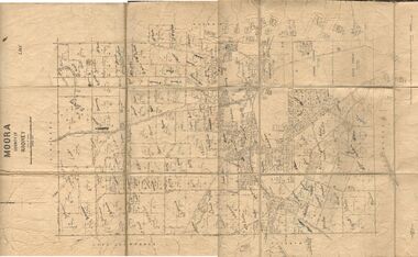
Map - JACK FLYNN COLLECTION: MOORA, 9/10/22
Map: Parish of Moora, County of Rodney. Parish plan.By Authority A.J. Mullet Government Printer Melbourne. Photo Lithographed at the Dept, of Lands and Survey, Melbourne by W.J. Butson. 3.10.22map, rodney, parish plan, moora -
 Bendigo Historical Society Inc.
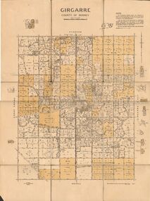
Map - JACK FLYNN COLLECTION: GIRGARRE, 14/10/1943
Map: Parish of Girgarre , County of Rodney. Parish plan. Same map as 10100.20 but in poorer condition.By Authority, H.E.Daw, Government printer Melbourne. Drawn and Reproduced at the Dept, of Lands and Survey, Melbourne, Victoriamap, rodney, girgarre, girgarre, county of rodney -
 Bendigo Historical Society Inc.
Map - JACK FLYNN COLLECTION: GIRGARRE, 14/10/1943
Map: Parish of Girgarre. County of Rodney. Parish plan.By Authority, H.E. Daw, Government Printer Melbourne. Drawn and produced at the Dept of Lands and Survey, Melbourne, Victoria. 14.10.1943map, rodney, parish plan, girgarre, county of rodney -
 Bendigo Historical Society Inc.
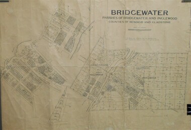
Map - JACK FLYNN COLLECTION: BRIDGEWATER, 6/10/1927
Map: Bridgewater , County of Bendigo. Parish plan.Photo Lithographed at the Department of Lands and Survey, Melbourne by W.J. Butson.map, bendigo, parish plan, bridgewater -
 Bendigo Historical Society Inc.
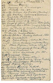
Document - NORMAN PENROSE COLLECTION: ART NOTES, 10 May
Document. Norman Penrose collection: battered notebook and 3 pieces of paper containing notes on art.education, tertiary, bendigo school of mines, norman penrose collection, art notes -
 Bendigo Historical Society Inc.
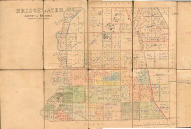
Map - JACK FLYNN COLLECTION: BRIDGEWATER, 10/09/1931
Map: Bridgewater, Parishes of Bridgewater and Inglewood, Counties of Bendigo and Gladstone. Parish plan.map, bendigo, parish plan, bridgewater inglewood -
 Bendigo Historical Society Inc.
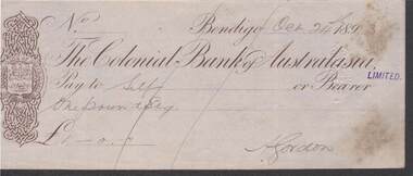
Document - KELLY AND ALLSOP COLLECTION: THE COLONIAL BANK OF AUSTRALASIA, CHEQUE, 24/10/1893
Document. KELLY & ALLSOP COLLECTION. A cheque drawn on the Colonial Bank of Australasia, Bendigo, dated 24 Oct. 1893. One Pound payable to self and signed by A.Gordon.A.Gordonbusiness, stockbroker, kelly & allsop, kelly & allsop collection, cheque, the colonial bank of australasia, a.gordon -
 Bendigo Historical Society Inc.
Map - INFANCY OF BENDIGO, Original dated 28/10/1890
Map: Photocopy of the First sketch map of the Bendigo Diggings. Has been assembled from several photocopies taped together. Laid before the Frencham Committee by William Sandbach , a witness, 18 September 1890. There are Two of these maps. ( x ref 5673 , 8235 , Box 83 , 9077 )map, bendigo, city streets, infancy of bendigo, gold diggings, henry frencham, william sandbach, where was gold first found -
Bendigo Historical Society Inc.
Map - PORTION OF ELMORE ESTATE, 19/10/1920
Map: Portion of Elmore Estate, Parish of Egerton, County of Bendigo. Parish plan Canvas backed ( number 135 in Map Cupboard 1)map, bendigo, rural, elmore estate, egerton, county of bendigo -
Bendigo Historical Society Inc.
Map - PORTION OF ELMORE ESTATE, 19/10/1920
Map: Portion of Elmore Estate, Parishes of Warragamba and Diggorra, County of Bendigo. Parish plan Canvas backed ( number 143 in Map Cupboard 1)map, bendigo, rural, elmore estate , warragamba, diggorra , county of bendigo. -
Bendigo Historical Society Inc.
Map - PORTION OF ELMORE ESTATE, 19/10/1920
Map: Portion of Elmore Estate, Parish of Minto, County of Bendigo. Parish plan Canvas backed ( number 131 in Map Cupboard 1)map, bendigo, rural, elmore estate, minto, county of bendigo -
 Bendigo Historical Society Inc.
Document - MCCOLL, RANKIN AND STANISTREET COLLECTION: DEBORAH GOLD MINE NL, Aug 1945 - 10 Oct 1947
Document. McColl Rankin & Stanistreet: Deborah Gold Mine NL. Hard cover folder containing handwritten statements of accounts of Deborah Gold Mines NL with the Bank of Australasia. Markings, inscriptions: Deborah Gold Mines NL on front cover.organization, mining, deborah gold mine nl, statement of accounts, deborah gold mine nl, mccoll rankin & stanistreet, bank of australasia -
Bendigo Historical Society Inc.
Map - SALISBURY WEST, 14/10/1943
Map: Salisbury West, County of Gladstone. Parish plan ( number 179 in Map Cupboard 1)map, gladstone, parish plan, salisbury west , county of gladstone -
Bendigo Historical Society Inc.
Map - PARISH OF LAANECOORIE, 13/10/1930
Map: Parish of Laanecoorie, County of Bendigo. Parish plan ( number 176 in Map Cupboard 1)map, bendigo, parish plan, laanecoorie -
Bendigo Historical Society Inc.
Map - MANDURANG, 8/10/1887
Parish of Mandurang, County of Bendigo. Traced from a re-survey of the Parish of Mandurang by Mr. Geo. Black 8/10.1887 ( number 158 in Map Cupboard 1)map, bendigo, parish plan, mandurang, re-survey, couny of bendigo -
 Bendigo Historical Society Inc.
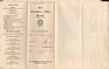
Document - MCCOLL, RANKIN AND STANISTREET COLLECTION: SOUTH DEBORAH GOLD MINE NL: SUN INSURANCE OFFICE: FIRE POLICY, 9/10/1940
Document McColl, Rankin and Stanistreet; Sun Insurance Office; Fire Policy; South Deborah Gold Mine NL, Number 17318164; 2 pagesorganization, mining, south deborah gold mines nl -
Bendigo Historical Society Inc.
Map - GOORNONG, 1/10/1906
Map: Township of Goornong, Parish of Goornong, County of Bendigo ( number 154 in Map Cupboard 1)map, bendigo, township, goornong, county of bendigo -
Bendigo Historical Society Inc.
Map - BEAR'S LAGOON, 2/10/1931
Map: Town of Munica ( name crossed out and Bear's Lagoon hand written in), Parish of Janiember east, County of Bendigo ( number 151 in Map Cupboard 1)map, bendigo, township, bear's lagoon, munica, janiember east, county of bendigo -
Bendigo Historical Society Inc.
Map - GOORNONG, 1/10/1906
Map: Town of Goornong, Parish of Goornong, County of Bendigo. Parish plan (number 269 in map cupboard 1)map, bendigo, township, goornong -
Bendigo Historical Society Inc.
Map - MINTO, 10/01/1884
Map: Minto, County of Bendigo. Parish plan. ( number 248 in Map Cupboard 1).map, bendigo, parish plan, minto -
Bendigo Historical Society Inc.
Map - WESTON, 21/10/1876
Map: Re-Survey of part of the parish of Weston, County of Rodney. Parish plan (number 309 in map cupboard 1)Murray and Hargreave, Authorised surveyorsmap, rodney, parish plan, parish of weston, murray and hargreave -
 Bendigo Historical Society Inc.
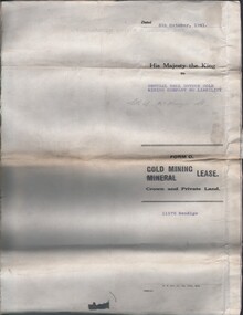
Document - MCCOLL, RANKIN AND STANISTREET COLLECTION: CENTRAL NELL GWYNNE, 5/10/1941
Document. Paper Document containing an indenture detailing lease between His Majesty the King to Central Nell Gwynne Gold Mining Company No Liability. Included is a map of the mining district of Bendigo Parish of Sandhurst. No 11172 Bendigo Vol 327 Fol 36016.McColl, Rankin & Stanistreetorganization, business, central nell gwynne, mccoll, rankin & stanistreet, central nell gwynne, gold mining, lease -
Bendigo Historical Society Inc.
Map - BRIDGEWATER, 10/09/1913
Map: Bridgewater, Parishes of Bridgewater and Inglewood, Counties of Bendigo and Gladstone (number 276 in map cupboard 1)map, bendigo, parish plan, bridgewater -
Bendigo Historical Society Inc.
Map - AVAILABLE ALLOTMENTS, 10/08/1908
map: Available Allotments, Parishes of Whirrakee, Bagshot and Egerton, County of Bendigo. Parish plan (coloured) (number 330 in map cupboard 1)map, bendigo, allotments, available allotments, whirrakee, bagshot, egerton -
 Bendigo Historical Society Inc.
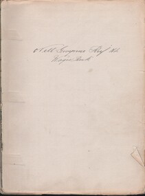
Document - MCCOLL, RANKIN AND STANISTREET COLLECTION: NELL GWYNNE REEF N/L - WAGES BOOK, 10/12/1040 - 22/9/1948
Document. Slightly damaged green spine, tan speckled/marble front & rear. No title on cover.McColl, Rankin & Stanistreetorganization, business, nell gwynne reef mine, mccoll, rankin & stanistreet, nell gwynne reef n/l, gold mining, wages book -
 Bendigo Historical Society Inc.
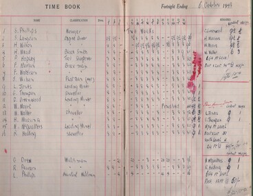
Document - MCCOLL, RANKIN AND STANISTREET COLLECTION: NELL GWYNNE REEF N/L - WAGES BOOK, 6/10/1948 - 30/11/1949
Document. Light brown book with dark brown binding. Only 1/3 of the book has been used.McColl, Rankin & Stanistreetorganization, business, nell gwynne reef mine, mccoll, rankin & stanistreet, nell gwynne reef n/l, gold mining, wages book -
Bendigo Historical Society Inc.
Map - DARGILE, 14/10/1906
Map: Parish of Dargile, County of Rodney. Parish plan (number 324 in map cupboard 1)map, rodney, parish plan, dargile