Showing 2435 items
matching black bridge
-
 Ballarat Tramway Museum
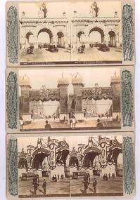
Photograph - Black & White Photograph/s, Rose Stereograph Co, 1901
Photographic reproduction - sepia coloured of a three stereo pair images with details on the sides. Originals made by the Rose Stereoscopic of Melbourne. All 1901 for the Duke of York visit for the opening of Federal Parliament in Melbourne. All feature cable trams. Printed on A4 size ink-jet printer. Set of three: 1 - Duke of York Celebrations, Melbourne, The Municipal Arch, Princes Bridge - image No. 2878 2 - ditto, the Butter Arch, Collins St - image No. 2894 3 - ditto - Prahran and St Kilda Arch, The Junction - image No. 2896.trams, tramways, melbourne, royal visit, cable trams, princes bridge, collins st, st kilda junction, stereo photograph -
 Ballarat Tramway Museum
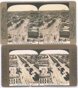
Photograph - Black & White Photograph/s, Rose Stereograph Co, c1905
Yields information about the appearance of the intersection of Sturt and Lydiard St and Sturt St itself looking west, showing the tram track arrangements.Photographic reproduction - sepia coloured of two stereo pair images with details on the sides. Originals made by the Rose Stereoscopic of Melbourne. Printed on A4 size ink-jet printer. Set of two: 1 - Sturt St and the Lydiard St intersection, electric trams looking east from the Town Hall. Shows Mount Warrenheip. Shows the roof of a tram in the bottom edge and a tram in Bridge St. Has the National Mutual building in the view, advertising the Commercial Union Fire (insurance) and Doepel and Chandler. Another building advertiser is "Carlton Ales" Image No. 8112 2 - Sturt St looking west from the Town Hall tower. Has one tram in the distance. Shows the layout of the Sturt St central median strip.trams, tramways, sturt st, lydiard st, stereo photograph, grenville st, esco, bridge st, town hall -
 Ballarat Tramway Museum
Photograph - Black and White - tram 17 Victoria St and East St, A T Miles, 30/1/1968
Black and White - tram 17 (Victoria St) at the intersection with East St, looking west. Shows the curve in Victoria St, just before the descent to Bridge St, Taken by A T Miles 30/1/1968.Yields information about the Victoria St route.Photograph - black and white print with notes on rear. Printed on Ilford paper.A T Miles stamp and location and date notes.tramways, trams, tram 17, victoria st, east st -
 Ballarat Tramway Museum
Photograph - Black and White - tram 11 Victoria St, A T Miles, 26/11/1969
Black and White - tram 11 in Victoria St crossing over the Eureka line bridge - former Buninyong railway line. Taken by A T Miles 26/11/1969. The tram has a Twin Lakes advert on the front. The destination has been changed for the return trip to the Gardens via Sturt St West.Yields information about services to Victoria St.Photograph - black and white print with notes on rear. A T Miles stamp and location and date notes.tramways, trams, tram 11, victoria st, eureka line, bridge, buninyong -
 Ballarat Tramway Museum
Photograph - Black and White - tram 36 Bridge St, A T Miles, 27/11/1969
Black and White - tram 36 (Victoria St), at Stones Corner, picking up 6 passengers. The man is carrying a Gladstone bag. The photo is looking west and has a Top 4 dry cleaners shop sign in the background. Taken by A T Miles 27/11/1969. The photo likely to have been taken before a 48-hour strike by SEC workers that commenced on that day. See item 8774. Yields information about services to Victoria St.Photograph - black and white print with notes on rear. A T Miles stamp and location and date notes.tramways, trams, stones corner, victoria st, bridge st, passengers -
 Ballarat Tramway Museum
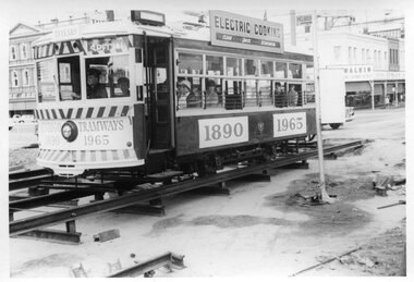
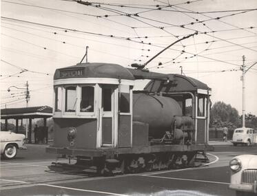
Photograph, Tramway Museum Society of Victoria (TMSV), Bendigo Birney 28 - bridgework, 1965
Photo shows Bendigo 28 decorated for the 75th anniversary of Bendigo trams (1890 to 1965) crossing temporary track at Charing Cross during the reconstruction of the Bendigo Creek bridge during early 1965 - see Electric Traction Vol. 20, No. 6, June 1965. The front cover has a photo by H R Clark of the decorated car. The photo shows the method of supporting the rails during the work prior to completion of concreting. Yields inforamation about bridge reconstruction in Bendigo and their 75th anniversary.Black and white photograph printTMSV Shop stamptrams, tramways, bendigo, birney, tram 28, bridgeworks, charing cross, 75th anniversary -
 Ballarat Tramway Museum
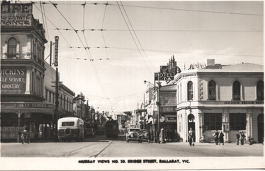
Postcard, Murray Views, "Murray Views No. 50 Bridge Street Ballarat Vic", 1948
Photo shows the view looking east along Bridge St from Grenville St. Bogie tram 35 is in the shadows. A bus is entering Bridge St, In the view are Dickins Self service grocery, Morseheads store, CTA Hotel, and the Bucks Head Hotel. On the rear, Wal Jack to Ken Magor of Newcastle has written "No. 35 bogie to Victoria St, 1948. Bridge St from Sturt and Grenville Sts. Note two green lights on the span pole under neon sign which guards the Bridge St (bottom light) and Victoria St single track. Mt Pleasant light is on opposite side pole. No. 35 is standing at the old city terminus up to 1937."Yields information about Bridge St Ballarat and its various buildings.Postcard black and white, divided back, with a handwritten note on rear.See image 2 for details of the handwritten note by Wal Jack on the rear. tramways, trams, bridge st, tram 35, buses, dickins, bucks head hotel -
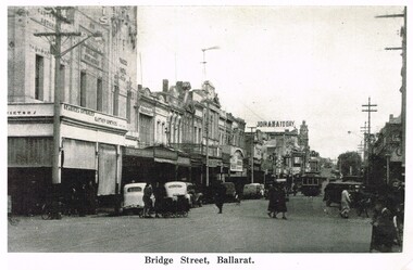
 Ballarat Tramway Museum
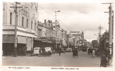
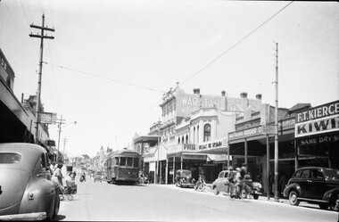
Postcard, Rose Stereograph Co, "Bridge Street, Ballarat Vic.", late 1930s
The photo shows tram 12 in Bridge St Ballarat on its way to Mt Pleasant. The photo is of Bridge St looking west from Peel St. In the photo are a butcher, a newsagent, a sign "Join ANA Today", along with two ladies with prams crossing the road. Wal Jack on the rear of the photo notes it is about 1940. Based on the cars in the photo, late 1930s. Item 5463 has a poor quality negative of this postcard. Yields information about Bridge St Ballarat during the late 1930sPostcard black and white, divided back, with a handwritten note on rear.See image 2 for details of the handwritten note by Wal Jack on the rear. tramways, trams, bridge st, tram 12 -
 Ballarat Tramway Museum
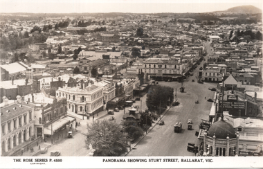
Postcard, Rose Stereograph Co, "Panorama showing Sturt Street, Ballarat Vic.", 1940s
The photo is a Panorama showing Sturt Street, taken from the Town Hall, looking north east with Mount Warrenheip and Black Hill in the view. Shows the buildings east of Lydiard St, including Bridge St, Camp St and part of Victoria St. One tram is westbound, about to cross Lydiard St. Rose Series P4500. Has signs for the "Mail Echo", Plume petrol, ANA, the Mechanics Institute, and Longhurs Bread. On the rear Wal Jack has written extensive notes for Ken Magor noting the streets in the view and the Ballarat East loco depot and Goods shed. Wal has dated the photo 1940 to 1944, though the trams do not have white bumper bars that featured from 1941 to 1945.Yields information about Ballarat during the 1940sPostcard black and white, divided back, with a handwritten note on rear.See image 2 for details of the handwritten note by Wal Jack on the rear. tramways, trams, bridge st, sturt st, ballarat east, rose postcards -
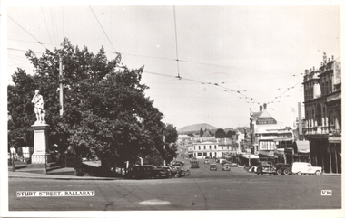 Ballarat Tramway Museum
Postcard, Valentine & Sons Publishing Co, "Sturt Street, Ballarat", c1950
The photo shows the view of the south side of Sturt Street from Lydiad St, looking east. The Robbie Burns statue is on the left of the card, along with the Mechanics Institute, The Ballarat Gas Co, Buckshead Hotel. There is one tram parked in the parking loop. On the rear, Wal Jack in a note to Ken Magor has written: "4 wheeler (No. 30 or 33?) in parking loop. Lower Sturt St from Lydiard St, looking east showing narrow Bridge St and Victoria St hill. Mt Warrenheip 4 miles away." Has a sketch of the tram tracks as well. C1950Yields information about Ballarat during the late 1940s or early 1950s.Postcard black and white, undivided back, with a handwritten note on rear. Card No. V39.See image 2 for details of the handwritten note by Wal Jack on the rear. tramways, trams, sturt st, valentine -
 Ballarat Tramway Museum
Postcard, "Bridge Street Ballarat", Original 1930's copy 2016
Yields information about the appearance of Bridge St in the late 1930's.Copy of black and white photograph of Bridge St, late 1930's with a single truck, possibly 12, in the viewpoint. Has a number of motor cars parked, looks west. In the view is a shop possibly with a sign "Grazers Butchers" and a "Join ANA Today". trams, tramways, bridge st, tram 671 -
 Ballarat Tramway Museum
Photograph - Black & White Photograph/s set of 2, Charles Craig, late 1950's?
Yields information about the traffic and appearance of Bridge St during the 1950's.Set of two black and white photographs of No. 27 west bound in Bridge St Ballarat, late 1950's. Has a FJ Holden and Volkswagen cars in the view. Tram has the destination of Gardens via Drummond St North. Photo by Charles Craig. Bank of NSW and Walter Davis Co. in the views. trams, tramways, bridge st, tram 27 -
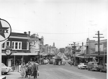 Ballarat Tramway Museum
Photograph - Black & White Photograph/s set of 2, Charles Craig, 1950s
Yields information about the traffic and appearance of Bridge St during the 1950's.Set of two black and white photographs of trams in Bridge St at the intersection with Main Road and Victoria St .1 - tram at the intersection with Stones Corner and other shops in the background. Includes the Caltex services station, the Listers for Service clock and direction sign, with many people leaving the tram and walking along Victoria St. Has the Gear Chemist, Ricksha Paint and other shops in the view. .2 - No. 28 - for Gardens via Sturt St West and the intersection. Photo possibly early 1950's. Both photos by Charles Craig trams, tramways, bridge st, main road, victoria st, tram 28 -
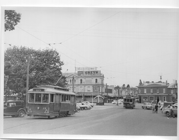 Ballarat Tramway Museum
Photograph - Black & White Photograph/s, Charles Craig, 1950's
Yields information about the use of the appearance of City Loop and the intersection with Grenville St during the late 1950's.Black and white photograph of Ballarat tram 19 in the City Loop and tram 30 in Sturt St, leaving Grenville St. Photo has a number of motor vehicles in the view, along with the Bucks Head Hotel, S E Dickins Grocery store on the north side of Bridge St, with adverts for Mobilgas and Greys cigarettes. The Grenville St shelter is in the view as well. Photo by Charles Craig possibly late 1950's. trams, tramways, sturt st, grenville st, city loop, tram 19, tram 30 -
 Ballarat Tramway Museum
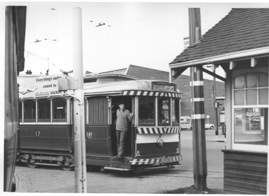
Photograph - Black & White Photograph/s, Charles Craig, early 1970's
Yields information about the intersection of Grenville and Sturt St, its use, the appearance and the shelter at this location.Black and White photograph of No. 17 crossing Grenville St from Bridge St, about to pass the tram shelter with a young man in the doorway. Tram has the destination of Gardens via Sturt St West and an Electric Cooking roof advert. Shows the tram stop and the Bridge St signal controller. Another tram is waiting for the 17 to clear the track. Photo by Charles Craig possibly early 1970's. trams, tramways, sturt st, grenville st, signals, shelters, tram stops, tram 17 -
 Ballarat Tramway Museum
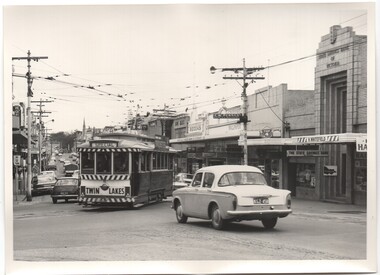
Photograph - Black & White Photograph/s, Charles Craig, 1971
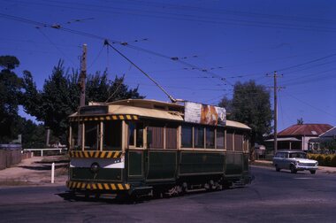
Yields information about Stones Corner, associated building and its use by trams in the period before the closure of the SEC system. Black and White photograph of tram of No. 11 at Stones Corner turning from Bridge St into Main Road. Tram showing Special, has a Twin Lakes sign and a Briquettes roof advert. In the background is H. Whitefield, the State Savings Bank of Victoria, a directional sign for C. W. Pennant wall paper Rodda and the ANZ bank? Photo by Charles Craig - during 1971. trams, tramways, bridge st, stones corner, main road, tram 11 -
 Ballarat Tramway Museum
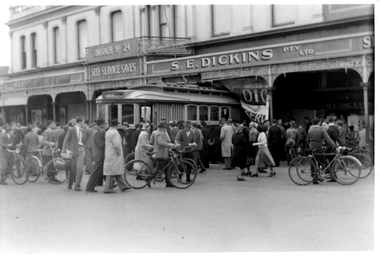
Photograph - Digital image, The Courier Ballarat, 1/10/1949 12:00:00 AM
Yields information about Ballarat 17 in an accident with a bus used a doughnut kitchen and S.E. Dickins Store, Bridge St Ballarat.Set of four images of photographs (two each same, different exposure) of Black and white photographs of SEC Tram 17 and a former bus used a food vendors stand, that have finished up in the front of S.E. Dickins Pty Ltd. (Grocers) store c1949. The tram derailed at the intersection of Sturt and Grenville St. collided with the bus and pushed it into the front of the store. Many people standing around the incident, including two trammies in front of the tram. See Reg Item 5587 for newspaper reports and 1020 for other photographs.trams, tramways, grenville st, accidents, s.e. dickins, tram 17 -
 Ballarat Tramway Museum
Photograph - Black & White Photograph/s, Negative, Ellis Collection, c1950
Yields information about the appearance of Bridge St and the use of the trams c1950.Black and white photograph of a bogie tram 22 west bound in Bridge St. Has a group of ladies on either side of the road waiting to board? Note the signs on the poles on either side of the roadway. Has the Waratah Motors, Roger David stores on the west side of the street. c1950. Note the road lifting over the Yarrowee River bridge. The two signs on either side of the road "No Parking over 1 hour Park 1 Foot from kerb" Negative number 1140. Negative scanned at 2400dpi. On the top edge of one of the prints "same as 1094"trams, tramways, ballarat, bridge st, signs, tram 22 -
 Ballarat Tramway Museum
Photograph - Black & White Photograph/s, Jim Seletto, 1955
Yields information about one of the MMTB scrubbers, No. 8, trams crossing Princes Bridge during 1955. This tram is now at the Museum.Black and White photograph of MMTB Scrubber tram No. 8 at the intersection of Batman Ave and Swanston St 1955, after coming off Princes Bridge. Has the Batman Ave terminus buildings in the background. Photo J. Seletto. Copy 2 - printed on postcard back.On rear in ink "Number 8 MMTB At Princes Bridge 1955" and "D Print Photo J. Seletto" and hand date stamp "17 Jan 1962" - this could be the print date.trams, tramways, scrubber tram, princes bridge, swanston st, batman ave, work trams, tram 8 -
 Ballarat Tramway Museum
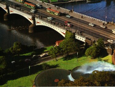
Postcard, Murfett Pty Ltd, Princes Bridge Melbourne, c1968
Colour postcard of Princes Bridge and South Gate Fountain Melbourne, late 1960's. Postcard shows the southern end of the Princes Bridge, has 3 W2's on bridge, each with marker lights and the South Gate fountains, existing at the time of the photograph. Since replaced by the Arts Centre. On rear is printed caption, giving details of the location, the date of the fountain construction (1959), stamp placement area and publishers details and post card number (8P 1053-2), National View by Murfett Publishers.On top edge near stamp area in black ink "1968".trams, tramways, melbourne, southgate, princes bridge, mmtb -
 Ballarat Tramway Museum
Slide - 35mm slide/s - set of 7, Noel Simons, 22/11/1962 12:00:00 AM
Set of 7 Kodachrome transparencies taken on 22/11/1962. 1161.1 - trams 38 and 20 in Sturt St. West at the Russell St. loop. No. 20 has possibly terminated and is showing "CITY" while 38 is showing "Mt Pleasant" Both trams fitted with dash canopy lighting, but no large white stripe. 20 has a Twin Lakes sign. 1161.2 - tram 33 just before Gardens Loop in Wendouree Parade, with destination of "Victoria St." Has a Twin Lakes sign. 1161.3 - tram 39 at corner of Lydiard St. North and Sturt St. with Post Office in background. 1161.4 - tram 40 turning from Sturt St into Lydiard St. North with Post Office in background and showing destination of Lydiard St. North. A blue Holden with red stripes for the Radio Cabs co. is in the foreground, along with pedestrians. 1161.5 - tram 41 in Sturt St. at the City terminus, showing destination of Mt Pleasant with Post Office and ANZ Bank buildings in background. Numerous people waiting on the seats at the tram stop. 1161.6 - tram 13 in Sturt St. near Doveton St. showing destination of Bell St. Many cars and pedestrians on the south side of Sturt St. Note the Austin motor car by the tram showing a stop signal. Tram 13 has a Twin Lakes sign. 1161.7 - trams 13, 26, and 39 in the City Loop near Bridge St. Has Morseheads and Grenville St. tram shelter in the background.1161.1 - "38 and 20 crossing in Sturt St. Ballarat near Russell Street" - in blue and black ink. The "Russell St" is a later addition, over white out. 1161.2 - "33 near Botanic Gardens terminus, Wendouree Parade, Ballarat" 1161.3 - "No. 39 in Lydiard St. Ballarat at Cnr. of Sturt St." 1161.4 - "No. 40 entering Lydiard St. from Sturt St. Ballarat" 1161.5 - "No. 41 in Sturt St. Ballarat at cnr of Lydiard St." 1161.6 - "No. 13 in Sturt St. Ballarat, at Cnr. of Doveton St." 1161.7 - "Nos. 13, 26, and 39 in Sturt St. Ballarat near Bridge St." All have date stamp of "22 Nov. 1962" in purple ink. All black ink unless otherwise noted.tramways, trams, ballarat, sturt st. west, wendouree parade, lydiard st., city loop, taxis, radio cabs, tram 13, tram 20, tram 26, tram 33, tram 38, tram 39, tram 40, tram 41 -
 Ballarat Tramway Museum
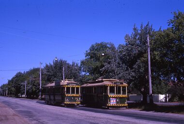
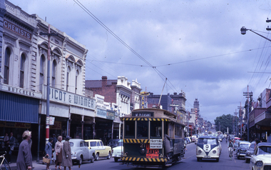
Slide - 35mm slide/s - set of 2, Noel Simons, 24/11/1962 12:00:00 AM
Set of 2 Kodachrome transparencies taken on 24/11/1962. 1163.1 - No. 21 in Bridge St., with destination of "Mt Pleasant" with a Twin Lakes advert and "Trotting Showgrounds Friday Night" auxiliary board on front dash panel. Also Picot & Widmer, chemists shop alongside tram. Tram at a stop with people boarding. 1163.2 - No. 13 and 30 crossing at the end of the double track in Sturt. St, at Grenville St. Both trams have Twin Lakes signs. Photo shows buildings either side of Sturt St.1163.1 - "No. 21 in Bridge St. Ballarat" 1163.2 - "No. 13 and 30 at foot of Sturt St. Ballarat" All have date stamp of "24 Nov. 1962" in purple ink. All black ink unless otherwise noted.tramways, trams, ballarat, bridge st, grenville st., sturt st., tram 13, tram 21, tram 30 -
 Ballarat Tramway Museum
Slide - 35mm slide/s - set of 9, Noel Simons, Sept. 1971
Set of 9 Kodak Ready-mount with slides made from the Association of Railway Enthusiast Provincial Tramways film strip. Reference Item 2560 details the ARE Film Strip, and provide references to other slides. See also Reg. item 1164. 1174.9 on plain white mount. 1174.1 - Tram 40 North bound for Lydiard St. North at the Railway Gates, with the gates closed. Tram carrying a heavy load of passengers. Railway station building and car park in background. Taken from the signal box. 1174.2 - Tram 12 bound for Gardens, photographed across the median strip plantation near Dawson St. Image i2a - adjusted 9/2021 to remove colour cast. 1174.3 - Tram 43 in bound along Wendouree Parade near Barrett Ave, passing a former tram stop and with "Warning Oncoming Trams" sign mounted on an adjacent pole. See also Reg. item 1172.1 for a photo taken in May 1971. This photo taken after the closure of the Victoria St. line, as the tram stop has been painted out. 1174.4 - Looking along the track to Sebastopol terminus on the west side of Albert St. - telephoto shot showing bogie tram in the far distance. Shows the nature of the track, poles, tram stop frequency and in the fare distance the terminus. Also show the trees that used to be along this section of the track. 1174.5 - No. 42 showing "Special" in Macarthur St. approaching Drummond St. north. Photo taken from under the verandah of a shop on the south side of the street that were many years later to become the Tramcar Restaurant. Note metal fence to cemetery. 1174.6 - Nos. 21 (Sebastopol) crossing 14 (Lydiard St. Nth) at the loop between Sayle and Grey St. Photo taken looking south. 1174.7 - No. 12 bound for Mt Pleasant, in Bridge St. about to stop at the junction for the two routes. Telephoto photo looking west along Bridge St. with many cars in the photo. Very few people on the street itself. 1174.8 - No. 30 and 17 at the City Terminus, on the north side of Sturt St. Taken from the Post Office corner with the Town Hall in the background. 1174.9 - No. 39 inbound along Sturt St. West. with many cars on the road. Bus stop on a pole on the other side of the road.1174.1 - "No. 40 on Lydiard St. North service waits at the level crossing at Ballarat Railway Station." 1174.2 - "No. 12 bound for 'Gardens' seen across the centre plantation in Sturt St." 1174.3 - "Barrett Ave." 1174.4 - "The Sebastopol route near the terminus" 1174.6 - "Nos. 21 and 14 crossing at Sayle St. Loop on Sebastopol route" 1174.7 - "No. 12 at Eastern end of Bridge St." 1174.8 - "Nos. 30 and 17 in Sturt St. at Cnr of Lydiard St." 1174.9 - "No. 39 City bound from 'Gardens" in Sturt St. West" All have date stamp of "Sep 1971" in black ink. Writing in blue ink.tramways, trams, lydiard st. nth, railway crossing, sturt st, wendouree parade, sebastopol, macarthur st., bridge st., sturt st. west, tram 12, tram 14, tram 17, tram 21, tram 30, tram 39, tram 40, tram 42, tram 43 -
 Ballarat Tramway Museum
Slide - 35mm slide/s, Noel Simons, 21/11/1962 12:00:00 AM
Set of 6 transparencies taken on 21/11/1962 on Kodak mounts. 1189.1 - Bendigo No.11 at Quarry Hill terminus. Photo taken looking in along the route. Tram has destination of North Bendigo. 1189.2 - No. 21 in Pall Mall bound for North Bendigo. Tram has roof ads for Mamouney's furniture and SEC. In the background are the National Bank building, Dad and Dave's Cafe and the Beehive Buildings and the London Pharmacy. 1189.3 - No. 2 in Mitchell St, just after crossing over railway bridge. Photo taken after tram has passed photographer. Has what appears to be an SEC road works crew in the background. Has destination of Quarry Hill. 1189.4 - No. 17 climbing Mitchell St. on the start of the single track section, just before crossing the railway bridge. Has destination of Quarry Hill and the large Maples building sign in the background. 1189.5 - as for 1189.4 but after tram has passed photographer. Has an Ilford film roof ad and an SEC roof ad. Railway bridge in the background. 1189.6 - No. 21 at Charing Cross with passengers boarding. Tram has destination of North Bendigo and roof ads for SEC 'Electric Cooking' and Sandhurst Milk. In background are the buildings on the south side of High St. Also has a SEC worker in white overalls sweeping the track.Information written on in black ink and date stamped on purple ink. 1189.1 - "Birney car No. 11 in High St. Bendigo at Golden Square terminus" 1189.2 - "No. 21 in Pall Mall Bendigo near Charing Cross" 1189.3 - "No. 2 in Mitchell St. Bendigo, just after crossing bridge over railway line (Quarry Hill route)" 1189.4 - "No. 17 in Mitchell St. Bendigo, climbing the hill the bridge over the railway line. (Quarry Hill route)" 1189.5 - "No. 17 in Mitchell St., Bendigo approaching bridge over Railway line (Quarry Hill route)" 1189.6 - "No. 21 at Charing Cross, Bendigo"tramways, trams, bendigo, golden square, pall mall, mitchell st., quarry hill, tram 2, tram 11, tram 17, tram 21 -
 Ballarat Tramway Museum
Slide - 35mm slide/s - set of 20, Noel Simons, 21/05/1971 12:00:00 AM
Set of 20 transparencies taken on 21/5/1971 on Kodak mounts. 1197.1 - Bendigo No. 5 en route to Eaglehawk at Creeth St Long Gully. Tram has a SEC roof ad and Cinzano roof ad. 1197.2 - No 5 approaching Needle Loop between Long Gully and California Gully. On left hand side is the City of Bendigo sign, indicating city boundary. 1197.3 - As for 1197.2 but actually entering loop. Photo taken after tram has passed photographer. 1197.4 - No. 26 bound for Eaglehawk descending the railway bridge near Eaglehawk, at Jobs Gully. 1197.5 - as for 1197.4, but after crossing bridge, now ascending a hill. Photo taken after tram has passed photographer. 1197.6 - No. 26 climbing High St. hill Eaglehawk, nearing end of Double track, bound for Quarry Hill. Shows centre of the road poles. 1197.7 - As for 1197.6, with tram entering single track section. Photo taken after tram has passed photographer. Has a BP service station in the background. 1197.8 - No. 26 (bound for Quarry Hill) crossing No. 17 (Eaglehawk) at Job's Gully Loop. 1197.9 - No. 17 climbing railway bridge at Job's Gully, en route to Eaglehawk. Photo taken after tram has passed photographer. 1197.10 - No.26 bound for Quarry Hill, leaving Long Gully Loop? Has the Creeth St. church in l197.l in the far background. Photo taken after tram has passed photographer. 1197.11 - Tramway Point work at the northern end of Long Gully Loop. 1197.12 - No. 17 en route for Quarry Hill turning into View St. from Bamard St. Tram has SEC roof ads "Everything fine in my all electric Kitchen' and 'Electric Cooking is Matchless'. 1197.13 - as for 1197.12, but tram has turned into View St and about to enter the double line track. Photo taken after tram has passed photographer. 1197.14 - No. 21 enters Nolan St after turning from MacRae St. en route to Bendigo. Note sign on its own post noting tram turns "Beware Tram Turns" and stop sign on adjacent pole "Trams stop on Request". No. 21 has two SEC roof ads. 1197.15 - No. 21 in Nolan St. after turning from Bridge St. (White Hills Road). Note signal light for Bridge St. loop on pole corner of street. Photo taken after tram has passed photographer. 1197.16 - No. 2 bound for Eaglehawk at unknown location. 1197.17 - Tram stop sign on a pole "CARS STOP BY REQUEST" 1197.18 - No. 5 in Carpenter St.? en route to Quarry Hill. 1197.19 - No. 28 has just arrive at Golden Square terminus, passengers are disembarking and the trolley pole is being turned. Golden Square Hotel in the background. 1197.20 - No. 28 at Golden Square terminus. Has a "Nothing beats Briquettes for hear roof ad. Information written on in black ink and date stamped on purple ink. 1197.1 - "No. 5 at Creeth St. Long Gully" 1197.2 - "No. 5 approaching Needle Loop between Long Gully and California Gully" 1197.3 - "No. 5 at Needle Loop between Long Gully and California Gully" 1197.4 - "No. 26 crossing railway bridge at Job's Gully near Eaglehawk" 1197.5 - "No. 26 just after crossing railway bridge at Job's Gully near Eaglehawk/ 1197.6 - "No. 26 in High St. Eaglehawk" 1197.7 - "No. 26 at end of double track in High St. Eaglehawk" 1197.8 - "Nos. 26 and 17 crossing at Job's Gully Loop" 1197.9 - "No. 17 crossing railway bridge at Job's Gully near Eaglehawk". 1197.10 - "No. 26 at Long Gully" 1197.11 - 'Northern end of points at Long Gully Loop". 1197.12 - "No. 17 turning into View St. from Bamard St. Bendigo". 1197.13 -'No. 17 at beginning of double track in View St. after leaving Bamard St. Bendigo. 1197.14 - "No. 21 enters Nolan St. from MacRae St. Bendigo." 1197.15 - "No. 21 in Nolan St. Bendigo just after leaving White Hills Road." 1197.16 - "No. 2" 1197.18 - "No. 5" 1197.19 - "Birney car No. 28 at Golden Square Terminus" 1197.20 "Birney car No. 28 at Golden Square Terminus" tramways, trams, bendigo, long gully, railway bridge, jobs gully, trackwork, nolan st, quarry hill, tram stops, golden square, tram 2, tram 5, tram 17, tram 21, tram 26, tram 28 -
 Ballarat Tramway Museum
Slide - 35mm slide/s - set of 13, Noel Simons, 24/05/1971 12:00:00 AM
Set of 13 transparencies taken on 24/5/1971 on Kodak mounts. 1200.1 - No. 7 en route to Golden Square turning from Bridge St. into Nolan St. Photo taken after tram has passed photographer. Tram has a briquettes roof ad. 1200.2 - No. 21 in McCrae St. just before Nolan St. Photo taken after tram has passed photographer. 1200.3 - No. 7 in Nolan St at corner with McCrae St. Passenger boarding tram at a tram stop. 1200.4 - No 7 turning from Nolan into McCrae St. with Golden Fleece service station in background. 1200.5 - No. 7 in Thunder St en route to North Bendigo. Photo taken after tram has passed photographer. 1200.6 - No. 5 en route to Eaglehawk just after leaving Needle Loop between Long Gully and California Gully. 1200.7 - No. 5 at the start of the double track in High St. Eaglehawk. 1200.8 - No. 5 at Eaglehawk terminus showing "Depot" with Leo A Hughes Photographer advertisement on building in background. 1200.9 - No. 5 at Eaglehawk terminus. Has two SEC roof ads 'Everything's fine in my all electric kitchen' and 'Electricity best for cooking'. 1200.10 - No. 5 at Eaglehawk terminus, with canon, war memorial outside Town Hall and Leo A Hughes Photographer advertisement on building in background. 1200.11 - No. 5 in McCrae St. about to enter Arnold St. and depot. Tram showing depot, has driver changing points. 1200.12 - No. 5 in Arnold St. Photo taken looking up the centre of the access track - shows the overhead at depot junction. 1200.13 - Depot entrance with signage at depot entrance and depot building in background.Information written on in black ink and date stamped on purple ink. 1200.1 - "No. 7 entering Nolan St. from Bridge St." 1200.2 -"No. 21 in McRae St. about to turn into Nolan St." 1200.3 - "No. 7 in Nolan St. at corner of McRae St." 1200.4 - "No. 7 turning from Nolan St. into McRae St." 1200.5 - "No. 7 in Thunder St. just after turning from Caledonia St." 1200.6 - "No. 5 just after leaving Needle Loop between Long Gully and California Gully. 1200.7 - "No. 5 in High St. Eaglehawk at start of double track." 1200.8 - "No. 5 at Eaglehawk terminus" 1200.9 - "No. 5 at Eaglehawk terminus" 1200.10 - "No. 5 at Eaglehawk terminus."\ 1200.11 - "No. 5 in McCrae St. about to enter Arnold St." 1200.12 - "No. 5 in Arnold St." 1200.13 - "Entrance to Bendigo Tram Depot, No. 5 running into shed."tramways, trams, bendigo, mccrae st, north bendigo, california gully, eaglehawk, depot, tram 5, tram 7, tram 21 -
 Ballarat Tramway Museum
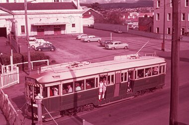
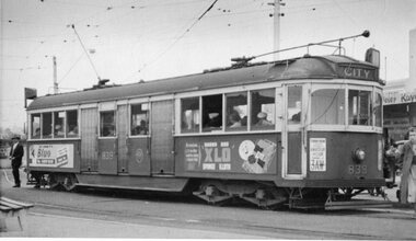
Photograph - Black & White Photograph/s, late 1950's or early 60's?
Black and white photograph, of MMTB W5 839 at the roundabout at corner of Mt Alexander Road and Fletcher St. Essendon, Essendon Station late 1950's or early 1960's. In the background is the railway bridge over Mt. Alexander Road. All blinds drawn. Tram showing destination "CITY". On the sides of the tram are advertisements for "Bluo" and "XLO Sponge cloth". On the front of the tram is an advertisement for radio station 3AW, Amateur Hour, Terry Dear. Photograph not well focused. trams, tramways, essendon, mmtb, mt alexander road, tram 839 -
 Ballarat Tramway Museum
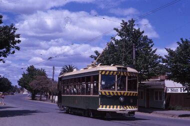
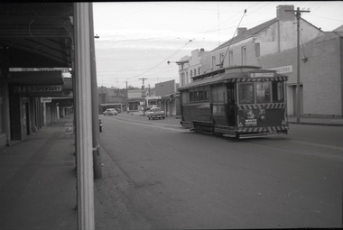
Photograph - B&W print of donated negative, Ron E. Fluck, 23/06/1962 12:00:00 AM
Black and white print of a donated negative. Print made 8/1998. Photo of SEC tram no. 31 in Main St, Ballarat East, with destination of "Gardens via Drummond St." Tram has been fitted with dash canopy lighting, but not the large white strip under the lighting. Has small triangles on the panels. Also has a small ad for White Horse whisky. Shows buildings on either side of Main St. and the Caltex service station in the background on Main Road and Bridge St. Photo taken 23-6-1962. Copy made Oct. 2001 for the "gold, Gold GOLD" temporary exhibition - colour laser print onto card, with Velcro dots on rear. Stored in box D1 (Display Box) 02/2003. High Res scan of negative added 17/1/2019.tramways, trams, main st, 31, ballarat, tram 31 -
 Ballarat Tramway Museum
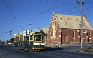
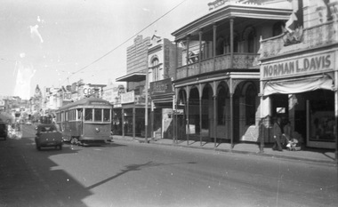
Photograph - B&W print of donated negative, Ron E. Fluck, 23/04/1950 12:00:00 AM
Black and white print of a donated negative. Print made 8/1998. Photo of SEC bogie tram No. 22 in Bridge St. Photo taken 23-4-1950. Destination of "Gardens via ???" in one line? Has Norman L.Davis building in foreground and buildings on either side of street. Negative has watermark on left hand side. High Res scan of copy negative added 17/1/2019tramways, trams, bridge st, 22, ballarat, tram 22 -
 Ballarat Tramway Museum
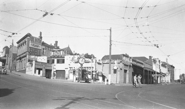
Photograph - B&W print of donated negative, Ron E. Fluck, 23/04/1950 12:00:00 AM
Black and white print of a donated negative. Print made 8/1998. Photo of the Lister's Junction Service Station, overhead and tram track at the intersection of Bridge St, Main St and Victoria St. (Stones Corner). Shows the style of overhead construction, signal contactors, the service station, its clock and associated advertising. Three ladies are crossing the road. Photo taken on 23.4.1950 at 3.05pm. Advertising on service station has Atlantic, Shell, and Castrol. Has multiple petrol dispensing bowsers. Clocks has directional arrows for Melbourne and Geelong. Tram tracks visible. Copy made Oct. 2001 for the "gold, Gold GOLD" temporary exhibition - colour laser print onto card, with Velcro dots on rear. Stored in box D1 (Display Box) 02/2003. high res scan of the negatives added 18/1/2019.tramways, trams, bridge st, stones corner, ballarat, main st