Showing 10466 items
matching plan
-
 University of Melbourne, Burnley Campus Archives
Plan, Arrangement of Soil Sterilizing Room for New Plant Science Laboratory at Burnley College of Horticulture, c. 1960
Plan by State of Victoria, Dept of Public Works. Drawn by R.M.department of public works -
University of Melbourne, Burnley Campus Archives
Plan, Detail of Sterilizing Trolley for New Plant Science Laboratory at Burnley Horticulture College, c. 1960
Plan by State of Victoria, Dept of Public Works. Drawn by R.M.department of public works -
University of Melbourne, Burnley Campus Archives
Plan - Photocopy, Burnley Site, c.1940
Part B. Photocopy of plan of site with proposed changes marked on it.burnley -
University of Melbourne, Burnley Campus Archives
Plan (Item), Vireya Rhododendrons
vireya rhododendron, burnley gardens -
University of Melbourne, Burnley Campus Archives
Plan, Landscape Construction I Paving on Mortar, 1990-2000
Plan of paving construction. Fall to Grade. Scale 1:20.landscape construction, paving -
University of Melbourne, Burnley Campus Archives
Plan - Planting Design, Gibson North Island Bed
emily gibson, plant list, garden plan -
University of Melbourne, Burnley Campus Archives
Plan, Business Services, Burnley Campus, 27.11.2020
plan of burnley campus, university of melbourne -
University of Melbourne, Burnley Campus Archives
Plan, Royal Horticultural Society's Garden
Changed boundaries of the site burnley gardens, survey paddock, flood, lynch design, richmond park, yarra river -
Bendigo Historical Society Inc.
Document - MARKS COLLECTION: PLAN FOR ALTERATIONS AND ADDITIONS TO FORTUNA
Copy of plan: Written on top RH corner of plan 'plan for alteration and additions to the private residence of Geo Lansell Sandhurst' Plan shows western, southern, and eastern elevations, plus roof plan. Bottom section of plan damaged. On bottom of plan '1/8 inch to one foot.'buildings, house, fortuna villa -
Clunes Museum
Plan - PLANS CLUNES CARAVAN PARK, NO. 1 - SHIRE OF TALBOT & CLUNES. IAN MANSLEY, SHIRE ENGINEER NO. 2 - LEO MCMAHON & ASSOCIATES PTY. LTD. LICENSED SURVEYORS & ENGINEERS, 31 LYONS ST. NTH. BALLARAT, 1976
NO. 1 PLAN - CLUNES CARAVAN PARK ENGINEER - IAN MANLEY NO. 2 PLAN - SECTION 15 TOWNSHIP OF CLUNES, COUNTY OF TALBOT, BY LEO MCMAHON AND ASSOCIATES, LICENSED SURVEYORS AND CIVIL ENGINEERSplans, caravan park, ian manley, plan section 15 -
University of Melbourne, Burnley Campus Archives
Plan (Item), Graphics Portfolio Assessment - 31 Lynch Street Hawthorn, 1992
Mark given by teachergraphics, garden layout, hawthorn, emma williams -
University of Melbourne, Burnley Campus Archives
Plan, Barkly Gardens, c. 1980
(1) Plan of park drawn in pencil on tracing paper. (2) 2 copies on tracing paper and 1 original on paper with 3 copies, plan by City of Richmond City Engineers Department.barkly gardens, city of richmond, urban landscapes -
 Warrnambool and District Historical Society Inc.
Documents, Swintons Paper att 18/53 Merri St. Contract. Map. Notes, 1959
These documents relate to the sale of land in Merri Street Warrnambool in 1959 by Swintons Pty Ltd of Warrnambool. The buyer of the land was George O’Grady, a Warrnambool baker. The land sold for £4000 and there was a shed on the land (called the ‘Office’) which George O’Grady indicated he wished to be included in the sale. William and Ann Swinton migrated to Australia in 1854 and for a decade William Swinton worked as a builder and carpenter in the Warrnambool area, erecting many buildings, including the Wangoom Presbyterian Church. In 1865 he opened a store in Timor Street Warrnambool, selling groceries, hardware, china and glassware. By 1888 the business was known as William Swinton and Sons. Branch stores were opened in Wangoom, Cudgee, Nullawarre, South Warrnambool and West Warrnambool. After William Swinton died his son Robert became the first managing director of Swintons Pty Ltd. In 1934 the business split with George Swinton and Sons selling clothing, furnishings and glassware and Swintons Pty Ltd selling seeds, produce and hardware. Today the Swinton family still operates a furniture and bedding shop in Timor St Warrnambool.These items are of some interest as being connected to the Warrnambool business of Swintons Pty Ltd. They will be of interest to researchers. The current Swinton business in Timor Street is the oldest family business in Warrnambool and, with the name Swinton associated with businesses in Timor Street Warrnambool for 152 years it is amongst the oldest family businesses in Australia.The items here relate to the sale of land by Swintons Pty Ltd., Warrnambool. .1 These are three pages of white paper with typed material, a lawyer’s signature in blue ink, one green stamp and a sketch of the land location. .2 This is a sheet of thick paper containing a plan of the land sold. The paper has printed material and a sketch of the land with part of it coloured in pink. .3 This is a small piece of paper torn at the bottom right edge. It has handwritten material (a letter) in blue ink..2 ‘Plan of Survey of Part of Crown Allotment 18 Section 3 Township of .2 ‘Plan of Survey of Part of Crown Allotment 18 Section 3 Township of Warrnambool Parish of Wangoom County of Villiers’ .3 ‘Tuesday Dear Mr Swinton I am writing to say that I would like to have the ‘Office’ Thanking You George O’Grady’swinton family,, warrnambool -
Bendigo Historical Society Inc.
Plan - MARKS COLLECTION: PLAN ALBERT PARK SERPENTINE FOR G. LANSELL
Copy of plan: written on top LH corner: Proposed Homestead Albert Park Serpentine for H. Lansell Esq. Scale eight feet to one inch. W. Beebe & G.D. Garvin Architects, late W. Beebe, Mitchell St. Bendigo. Plan shows front, back and side elevation with floor plan for residence.buildings, house, albert park serpentine -
 Kew Historical Society Inc
Map, Real Estate Map of Bulleen, Templestowe, Lower Templestowe, Doncaster, North Balwyn
A large undated printed map of Bulleen, Templestowe, Lower Templestowe, Doncaster, North Balwyn showing major and minor roads, waterways and proposed facilities in this area of Melbourne.A useful if undated real estate map that allows viewers to compare current and historic aspects of these areasMap of Bulleen, Templestowe, Lower Templestowe, Doncaster, North Balwyn used by JB Thomson & Co, Real Estate Agents, to identify and record land sales on these. There are some markings on the plan indicating the location and price of lots.subdivision plans, bulleen, templestowe, lower templestowe, doncaster, north balwyn -
Ringwood and District Historical Society
Envelope, Packet: Ringwood Planning and Development Clippings and Newsletters 1970s-1990s, 1990-1991
Planning and Development newspaper clippings on planning matters -
Port Melbourne Historical & Preservation Society
Plan - Metalling and chanelling, Boundary Street South, Graham Street to St Vincents Street, 14 Mar 1893
Specifications (Reg. 77.1) and plan (Reg 77.2) for metalling and channelling Boundary Street South [Pickles Street] from Graham Street to St. Vincents Street. Loan works 1893, plan No. 5.J.J. Bartlett (Mayor) 14/3/93engineering - roads streets lanes and footpaths, town planning, town clerks, mayors, arthur victor heath, james john bartlett -
 Kew Historical Society Inc
Plan - Subdivision Plan, Wimba Estate, Kew, c.1925-c.1929, ca. 1925-ca. 1929
Pru Sanderson, in her groundbreaking ‘City of Kew Urban Conservation Study : Volume 2 - Development History’ (1988), summarised the periods of urban development and subdivisions of land in Kew. The periods that she identified included 1845-1880, 1880-1893, 1893-1921, 1921-1933, 1933-1943, and Post-War Development. These periods were selected as they represented periods of rapid growth or decline in urban development. An obvious starting point for Sanderson’s groupings involved population growth and the associated economic cycles. These cycles also highlighted urban expansion onto land that was predominantly rural, although in other cases it represented the decline and breakup of large estates. A number of the plans in the Kew Historical Society’s collection can also be found in other collections, such as those of the State Library of Victoria and the Boroondara Library Service. A number are however unique to the collection.Subdivision plans are historically important documents used as evidence of the growth of suburbs in Australia. They frequently provide information about when the land was sold on which a built structure was subsequently constructed as well as evidence relating to surveyors and real estate and financial agents. The numerous subdivision plans in the Kew Historical Society's collection represent working documents, ranging from the initial sketches made in planning a subdivision to printed plans on which auctioneers or agents listed the prices for which individual lots were sold. In a number of cases, the reverse of a subdivision plan in the collection includes a photograph of a house that was also for sale by the agent. These photographs provide significant heritage information relating house design and decoration, fencing and household gardens.In 1925, the City of Kew called for tenders for the construction of Wimba Avenue, Cadow Street and Lalla Street. Subsequent advertisements for the sale of land in Wimba Avenue continued from 1926 to 1929. The 18 lots (and a further five allotments on the eastern side of the street) offered for sale were unofficially described in the subdivision plan as the ‘Wimba Estate’. These lots began in Park Hill Road and extended almost to Cotham Road. The subdivision took its name from the house ‘Wimba’ in Cotham Road, which may have formed the southern boundary of the subdivision. (Wimba, at 235 Cotham Road was constructed between 1862-70). The Plan highlights the proximity and advantage of ‘electric’ trams in Cotham and Glenferrie Roads, and the Kew and Glenferrie Railway Stations. An oddity in the Plan is the reference to the electric tram terminus at Burke Road, given that the tramline had already been extended to Mont Albert in 1916.wimba estate, subdivision plans - kew, parkhill road – kew (vic.), normanby road – kew (vic.), wimba avenue – kew (vic.) -
University of Melbourne, Burnley Campus Archives
Plan, Jacqueline Fraser, The Chivers House 34 Finlayson Street Malvern East, 1991
(1) Jacqueline Fraser - Site Inventory and Analysis dated 5.11.91, Conceptual Design dated 1.11.91, Planting Plan and Section Elevation dated 8.11.91. Scale 1:100. (2) Troy Watchorn - Site Analysis and Inventory, Concept Plan, Planting Plan, Section Elevation, dated 14.11.1991. Scale 1:100. (15 sheets)jacqueline fraser, troy watchorn, landscape design, malvern -
Glenelg Shire Council Cultural Collection
Plan - Plan - CRB concrete handrail, n.d
Port of Portland Authority Archivesport of portland archives -
Glenelg Shire Council Cultural Collection
Plan - Plans - Machinery, n.d
Port of Portland Authority Archivesport of portland archives -
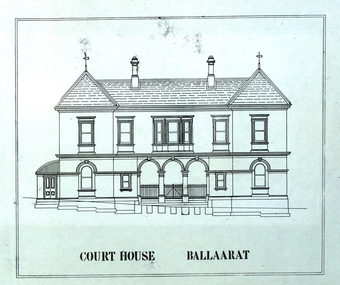 Federation University Historical Collection
Plan - Plans, Former Ballarat Courthouse Refurbishment, 1986, 1986
A number of plans relating to the refurbushment of the Former Ballarat Supreme Courthouse into a theatre.ballarat court house, performing arts, theatre, ballarat school of mines, smb courthouse theatre, courthouse theatre, ewan jones and associates -
Port Melbourne Historical & Preservation Society
Plan - Inner East, Ferry Terminal, Station Pier, Port Melbourne, Engineering Division, Port of Melbourne Authority, 1983
Plan - General arrangement - Station Pier - Inner East - ferry terminalmelbourne harbor trust - port of melbourne authority -
Port Melbourne Historical & Preservation Society
Plan - Drainage, Board of Works, William Pentland (Coach builders), corner Ingles Street and Crockford Street, 21 Dec 1939
Board of Works drainage plan for William Pentland (coach builders) 1939built environment - industrial, sue pentland, william pentland -
Port Melbourne Historical & Preservation Society
Plan - Crockford Street, Ingles Street and Raglan Street, Port Melbourne, Sep 1947
Plan of area Ingles St; Crockford St and Raglan St, 1947built environment - commercial, sue pentland, william pentland -
Port Melbourne Historical & Preservation Society
Plan - Plans, Sandridge City Development Corporation, 1989
Book of development plans for Sandridge City Development corporation June 1989local government - city of port melbourne, town planning - proposals shelved - bayside, sandridge city development company pty ltd, scdc, beacon cove, mirvac -
Port Melbourne Historical & Preservation Society
Plan - Façade, Port Melbourne Town Hall, Port Melbourne City Council, 1916
Plan - Details of building front of 1915 Port Melbourne Town Hall.port melbourne town hall -
Port Melbourne Historical & Preservation Society
Plan - Fire bell tower, Port Melbourne, 16 Jan 1890
Plan, elevation of fire bell tower, 1890 (Borough of Port Melbourne)Town Clerk's stamp, plus signatures of Town Clerk E. CLARK, contractor John BRODERICK and E CROCKFORD (witness).:"Fire Bell Tower", on backfire and fire services, edward clark, town clerks, john broderick, edward john crockford -
Port Melbourne Historical & Preservation Society
Plan - Walter Avenue, Port Melbourne, Town of Port Melbourne, 1893 - 1919
Plan of Walter Avenue showing various cross sections, date unknown.engineering - roads streets lanes and footpaths, walter avenue, loans program -
Port Melbourne Historical & Preservation Society
Plan - Raglan Street from Williamstown Street to Ross Street, 14 Mar 1893
Plan of Raglan Street from Williamstown Road to Ross Street, 1893engineering - roads streets lanes and footpaths, town planning, town clerks, mayors, arthur victor heath, james john bartlett