Showing 2080 items matching "eltham council"
-
 Eltham District Historical Society Inc
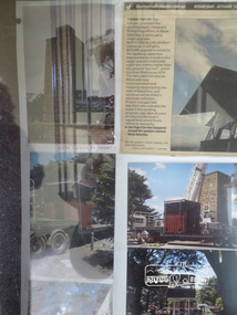
Photograph, Shire of Nillumbik World War One Memorials tour, 10 August 2016, 10 August 2016
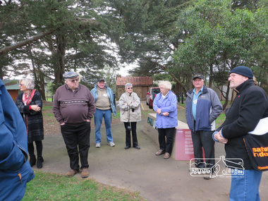
As part of a program to acknowledge the Anzac Centenary Nillumbik Shire Council partnered with Yarra Plenty Regional Library to provide a bus tour with commentary of local sites of significance. These included Eltham township, the Shire of Eltham War Memorial at Kangaroo Ground, Christmas Hills, Hurstbridge memorial recreation park and finished at Eltham Library to view the Writing the War exhibtion at Eltham Library Community Gallery. Dennis Ward (right hand side) of "The Friends of Kangaroo Tower" gives a brief presentation about the site. Born Digitalworld war 1, war memorials, shire of nillumbik, kangaroo ground, kangaroo ground memorial, tour, dennis ward -
 Eltham District Historical Society Inc
Photograph, Shire of Nillumbik World War One Memorials tour, 10 August 2016, 10 August 2016
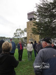
As part of a program to acknowledge the Anzac Centenary Nillumbik Shire Council partnered with Yarra Plenty Regional Library to provide a bus tour with commentary of local sites of significance. These included Eltham township, the Shire of Eltham War Memorial at Kangaroo Ground, Christmas Hills, Hurstbridge memorial recreation park and finished at Eltham Library to view the Writing the War exhibtion at Eltham Library Community Gallery. Kangaroo Ground War Memorial Park.Born Digitalworld war 1, war memorials, shire of nillumbik, tour, kangaroo ground, shire of eltham war memorial -
 Eltham District Historical Society Inc
Photograph, Kangaroo Ground War Memorial Park: Photo display, 10 August 2016
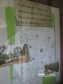
Display in glass cabinet at the base of the stairs at the tower at Kangaroo Ground. 7 windmill palms are growing around the tower. They represent 6 states and 1 for the Territories with map and photo. As part of a program to acknowledge the Anzac Centenary Nillumbik Shire Council partnered with Yarra Plenty Regional Library to provide a bus tour with commentary of local sites of significance. These included Eltham township, the Shire of Eltham War Memorial at Kangaroo Ground, Christmas Hills, Hurstbridge memorial recreation park and finished at Eltham Library to view the Writing the War exhibtion at Eltham Library Community Gallery. Born Digitalworld war 1, war memorials, shire of nillumbik, heritage display, shire of eltham war memorial, kangaroo ground -
 Eltham District Historical Society Inc
Photograph, Liz Pidgeon, Kangaroo Ground War Memorial Park: Photo display, 10 August 2016
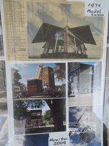
Glass cabinet at the base of the stairs at the tower showing colour photographs depicitng the installation of the CFA tower in November/ December 2009. As part of a program to acknowledge the Anzac Centenary Nillumbik Shire Council partnered with Yarra Plenty Regional Library to provide a bus tour with commentary of local sites of significance. These included Eltham township, the Shire of Eltham War Memorial at Kangaroo Ground, Christmas Hills, Hurstbridge memorial recreation park and finished at Eltham Library to view the Writing the War exhibtion at Eltham Library Community Gallery.Born Digitalworld war 1, war memorials, shire of nillumbik, kangaroo ground, heritage display, shire of eltham war memorial, cfa -
 Eltham District Historical Society Inc
Photograph, Liz Pidgeon, Kangaroo Ground War Memorial Park: Photo display, 10 August 2016
Glass cabinet at the base of the stairs at the tower showing colour photographs depicitng the installation of the CFA tower in November/ December 2009. As part of a program to acknowledge the Anzac Centenary Nillumbik Shire Council partnered with Yarra Plenty Regional Library to provide a bus tour with commentary of local sites of significance. These included Eltham township, the Shire of Eltham War Memorial at Kangaroo Ground, Christmas Hills, Hurstbridge memorial recreation park and finished at Eltham Library to view the Writing the War exhibtion at Eltham Library Community Gallery. Born Digitalworld war 1, war memorials, shire of nillumbik, kangaroo ground, heritage display, shire of eltham war memorial, cfa -
 Eltham District Historical Society Inc
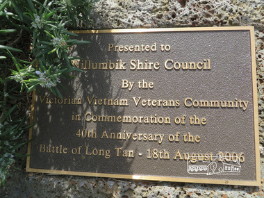
Photograph, Liz Pidgeon, Kangaroo Ground War Memorial Park: Plaque, 10 August 2016
Presented to Nillumbik Shire Council by the Victorian Vietnam Veterans Community in commemmoration of the 40th anniversary of the Battle of Long Tan - 18th August 2006.Born Digitalworld war 1, war memorials, shire of nillumbik, plaque, vietnam veterans community -
 Eltham District Historical Society Inc
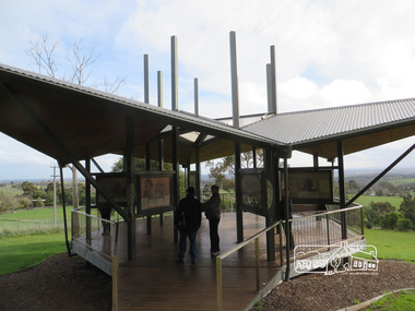
Photograph, Liz Pidgeon, Moor-Rul Viewing Platform, 10 August 2016
The Moor-Rul Viewing Platform, part of the Kangaroo Ground War Memorial Park opened in April 2007. Eight double-sided interpretation panels on the Moor-rul viewing platform highlight the area's Aboriginal and European history of the area and also details of local geology, flora and fauna. These panels feature high quality graphic design and professionally written text. The subjects covered are: ''Womin Je Ka" Welcome The Kulin Nation Singing, Dancing, Ceremony, Celebration This Country, My Home The Highland Taken Auld Lang Syne "Same Land Different Views" Working the Land Food from the Earth or "Earth's Harvest" Lest We Forget, "And with the going down of the Sun .... (3 panels) This Black Earth Those other indigenous inhabitants - Kangaroo Ground's Wildlife Silent Witnesses - Kangaroo Ground's White Manna Gums Belonging A Place of Reverence and A Tower of Strength Souce: EDHS Newsletter No 173 March 2007. As part of a program to acknowledge the Anzac Centenary Nillumbik Shire Council partnered with Yarra Plenty Regional Library to provide a bus tour with commentary of local sites of significance: Shire of Nillumbik World War One Memorials tour, 10 August 2016. These included Eltham township, the Shire of Eltham War Memorial at Kangaroo Ground, Christmas Hills war memorial, Hurstbridge memorial recreation park and finshed at Eltham Library to view the Writing the War exhibtion at Eltham Library Community Gallery.Born Digitalshire of nillumbik, moor-rul viewing platform, kangaroo ground -
 Eltham District Historical Society Inc
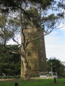
Photograph, Shire of Eltham War Memorial, 10 August 2016
As part of a program to acknowledge the Anzac Centenary Nillumbik Shire Council partnered with Yarra Plenty Regional Library to provide a bus tour with commentary of local sites of significance. These included Eltham township, the Shire of Eltham War Memorial at Kangaroo Ground, Christmas Hills, Hurstbridge memorial recreation park and finished at Eltham Library to view the "Writing the War" exhibition at Eltham Library Community Gallery. Shire of Eltham War memorial at Kangaroo Ground War Memorial ParkBorn Digitalworld war 1, war memorials, shire of nillumbik, kangaroo ground, shire of eltham war memorial, tower, fire spotting cabin, park -
 Eltham District Historical Society Inc
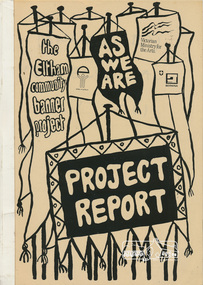
Book, Jacky Talbot, The banner habits of the Eltham tribes : Eltham Shire "as we are" Community Banner Project report / by Jacky Talbot, 1987
Also titled: Eltham Shire "As We Are"The 'As We Are' Community Banner Project was the first major Community Arts project initiated and co-ordinated through the resources of the Shire of Eltham. It was originally conceived and inspired by a local textile artist, Tracey Naughton, who, together with the Community Services Manager of this local government council, made the idea a very concrete and flourishing reality. As the following report reveals, the project grew from the original fourteen or so intending participant groups to fifty-seven banners; expressions of those diverse groups' interests and identities. As a first major project it was rightly felt by Tracey Naughton, who became the Shire's first Community Arts Officer in March 1985, that it should be fully documented, so that an appraisal of the extensive growth of this community arts development process could be assessed. Given the time and money available to do this the writer, Jacky Talbot, and her advisors, decided it was appropriate to select fifteen or twenty banners for detailed analysis. This was done by taping interviews with members of the chosen groups. The groups were chosen to cover all ages participating, from the toddlers in the Playhouse to our grand elder citizens in their Nursing Horne, and to cover a wide range of different types of groups - schools, scouts, churches, youth issue based, and the numerous women's groups of various combinations, localities and concerns. ·. Some groups who presented their banners for the culminating highlight of this project - the Exhibition, held at the Eltham Community Centre on October 9th, 1986, had no contact with the Shire or project co-ordinator, but heard about the project through the local news' networks or other participants. The extent of community participation was enormous. It involved hundreds and hundreds of people. It changed some people's lives, enlivened others. As a first step on a new road its success is notable. The 'As We Are' Community Banner Project took place in the Shire of Eltham and neighbouring environs for approximately 12 months, from October 1985. Paperback; 68, [10] leaves : ill. ; 30 cm. Two copiesflags, emblems, banners, eltham, shire of eltham, community -
 Eltham District Historical Society Inc
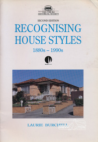
Book, Laurie Burchell, Recognising House Styles by Laurie Burchell, c1981
House styles in Victoria 1880s to 1990s40 p. : ill. ; 30 cm.ISBN 095889664Xhouse styles victoria 1880s to 1990s -
 Eltham District Historical Society Inc
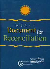
Book, Council for Aboriginal Reconciliation (Australia), Draft Document for Reconciliation (folder containing loose leaflets), 1999
Draft document for reconciliation for discussion by the Australian people.1 portfolio (various pieces) ; 31 cm.aboriginal reconciliation -
 Eltham District Historical Society Inc
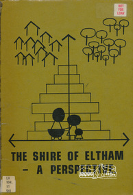
Book, Shire of Eltham, The Shire of Eltham - A Perspective, July 1981
... - introduction, the Shire of Eltham, physical characteristics, historical ...This report was produced by the Shire of Eltham (Planning Department) following a population study of the Shire. It also includes other areas of general interest. The Document contents includes Present and Future - Population - Housing - Residential Lands - Social Characteristics - Development and History. Includes maps, tables and diagrams. Part 1: The Existing situation - introduction, the Shire of Eltham, physical characteristics, historical development, population growth. Characteristics of the population - size and distribution, age / sex, natural increase, migration. Socio-Economic Factors: socio-economic status, employment/workforce, education, other social factors. Housing/ building statistics: characteristics of Housing stock, current residential trends, other types of building activity. Residential Land: existing vacant lots, estimated additional lots. Part 2: The Future. Land availability, the future population.The Shire of Eltham Council resolved on publication of this report "to commend it to the ratepayers as a most valuable resource document". It provides a comprehensive statistical review of the Shire of Eltham, Victoria in 1981 with some population and development predictions for the future.Spiral bound, soft cover, includes indexBarcode and identification markings including stamped "WITHDRAWN" from Heidelberg Regional Library Serviceshire of eltham, planning, population -
 Eltham District Historical Society Inc
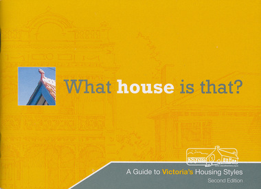
Book, Heritage Council of Victoria, What House Is That?: a guide to Victoria's housing styles, 2007
Guide to housing styles in the state of Victoria31 p. : ill. ; 17 x 22 cm.building styles victoria -
 Eltham District Historical Society Inc
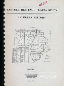
Book, Banyule City Council, Banyule Heritage Places Study - An Urban History, Volume 1 prepared by Allom Lovell & Associates, 1998 March
Describes the broad patterns of development across Banyule in the post-European contact period, 92 p, 30 cmbanyule history, greensborough history, montmorency history, heidelberg history, ivanhoe history -
 Eltham District Historical Society Inc
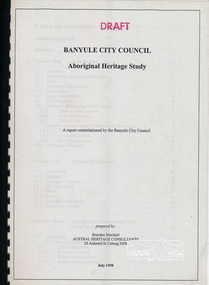
Book, Banyule City Council Aboriginal Heritage Study prepared by Austral Heritage Consultants, 1998 July
A draft report on the pre-European Aboriginal achaeological sites in the city of Banyule, including results of previous field surveys; Banyule covers a small part of the former lands of the Woi Wurrung. The report discusses heritage overlay, planning issues and the proposed Victorian planning provisions.100p, 30 cm.Marked "Draft"aboriginal heritage banyule, woi wurrung -
 Eltham District Historical Society Inc
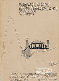
Book, Graem Butler, Heidelberg Conservation Study, Part 1 Heidelberg Historic Buildings and Areas Assessment by Graeme Butler, November 1985
Historic Buildings and Areas Assessment by Graeme Butler. Part 1 of award winning study carried out in 1982 in collaboration with a community advisory committee to Heidelberg City Council. Pioneering identification of a broad range of heritage assets varying from buildings, gravestones, farm structures, landscape areas, mileposts, divided street construction, in a time when buildings only were assessed in municipal studies.2 v. : ill., maps ; 29 cm.significant buildings heidelberg victoria, history development of heidelberg victoria, man-made landscape heidelberg victoria, significant precincts heidelberg victoria, conservation study, graeme butler -
 Eltham District Historical Society Inc
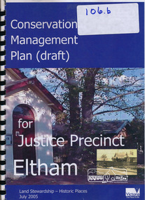
Book, Conservation Management Plan - Eltham Justice Precinct (January 2006) prepared for Nillumbik Shire
Guidance on the heritage issues in the management of the court house and former police buildings of the early justice precinct at Eltham.68 p, 30 cm. Also draft copy - Conservation Management Plan (draft) for Justice Precinct Eltham (July 2005) prepared for Nillumbik Shire 2006 This copy is the property of the Eltham District Historical Society Inc.eltham justice precinct, justice precinct eltham -
 Eltham District Historical Society Inc
Book, Ivar Nelsen, Conservation Management Plan (draft) for Justice Precinct Eltham (July 2005) prepared for Nillumbik Shire, 2006
Draft for report on guidance on the heritage issues in the management of the court house and former police buildings of the early justice precinct at Eltham.39 p, 30 cm.Harry Gilham E.D.H.S. Inc.eltham justice precinct, justice precinct eltham -
 Eltham District Historical Society Inc
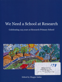
Book, Research Primary School, We Need a School at Research - celebrating 125 years at Research Primary School, edited by Maggie Sakko, 2014
History of Research Primary School, north-eastern suburb of Melbourne. Begins with condensed version of the 1989 history of first 100 years, then covers 25 years 1989-2014: buildings and facilities, principals, teachers, students, uniform, School Council, Parents Group, out of school care, curriculum, and special events such as productions and camps. Registers of principals, staff and students are included. Numerous photographs are included.100 pages : illustrations, portraits ; 28 cm.ISBN 9780646925172research (vic.) -
 Eltham District Historical Society Inc
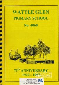
Book, Wattle Glen Primary School No. 4060 - 75th anniversary 1922-1997, 1997
Includes black and white photos and sections: General history of Wattle Glen and surrounding area, gold mining, 4060 Wattle Glen, Opening school buildings (newspaper articles from The Advertiser, 1922), Sunnyside Estate Wattle Glen, Wattle Glen 4060, copies of early documents, parents protest for a new classroom, I remember Wattle Glen School Days (various recollections over various years includes class photographs), Wattle Glen Primary School Today inc. lists of staff and students 1982. Second Section titled: 1997 - 75th anniversary update From the Principal, School Council, Parents Association, Newer memories, computers at Wattle Glen, Past teachers 1983-1997, 1997 classes, memories Kathleen Cuxson, Reunion 1997, Memories of Cyril Cummins (Principal 1950-52), 1997 memories, 1997 update compiled by Naomi Windisch. No page numbers This book is significant in that it documents the history of the Wattle Glen Primary School and its wider community to 1997. It is one of a very few publications written specifically on this rural community within the Shire of Nillumbik.Spiral Bound. Inscribed - For the Eltham Historical Society Collection in exchange for the '1999 Chronology', 27/4/9975th anniversary, state school no. 4060, wattle glen primary school -
 Eltham District Historical Society Inc
Photograph, Entrance to Shire of Eltham Memorial Park, Garden Hill, Eltham-Yarra Glen Road, Kangaroo Ground, c.1923
... necessary works." A history summary of the Shire of Eltham Soldiers... necessary works." A history summary of the Shire of Eltham Soldiers ...View to south-east from Shire of Eltham Soldiers' Memorial Park showing the carriageway from the road to top of Memorial Park. Accompanying notes state that the entry gate was put in place in May 1921. Eltham and Whittlesea Shire Advertiser and Diamond Creek Valley Advocate Fri 21 May 1920 p 2 reported: Kangaroo Ground Memorial Park "It was decided to arrange for a working bee on Saturday, 29th inst., for the purpose of forming and gravelling the track leading to the Park, and of carrying out other necessary works." A history summary of the Shire of Eltham Soldiers’ Memorial Park • The summit at Garden Hill was a popular tourist lookout and picnic spot from the 1880s. Virtually the entire Shire of Eltham and beyond could be viewed from this location. • A local farmer, Mr Walter A. D. Wippell is credited as being the first to propose the idea of a war memorial park and offered £50 towards the purchase of the land. • The earliest public reference to this project is to be found in the local Advertiser newspaper edition of August 9th, 1918. A report of the August Council meeting records the Eltham Shire President, Cr. Robert White, saying: "some time back it was proposed that the Council obtain and place on an Honour Board in the Council Chamber [at Kangaroo Ground] containing names of the lads who had enlisted. Just recently however, it had been suggested that a more fitting memorial would be the obtaining of a piece of land on the summit of Garden Hill, Kangaroo Ground, and the formation of a memorial park in which a monument could be erected to represent the whole of Shire. If a couple of acres could be obtained a gentleman had promised to donate 50 pounds, and another one would fence it, and other contributions, he was sure, could be obtained." • Councillors were favourable of the proposal and the President, Shire Secretary and Shire Engineer were deputised to wait on Messrs Mess Bros. (the owners of the Garden Hill farm) and ascertain if they would gratuitously give the land. The Mess Bros. land adjoined the farm/stud of Mrs Fanny White (Cr Robert White’s mother), daughter of Andrew Harkness who established their property on Garden Hill around 1846. • Access to the land came in February 1919 when several Councillors and the Shire Engineer surveyed the actual two acres of '5 chains along the road and 4 chains deep'. The Engineer volunteered his services free to do this task. The Mess brothers however demanded £100 per acre but eventually agreed to take £50 per acre. • Entry from the Kangaroo Ground-Yarra Glen road was seen to be a problem and Mrs. White, who owned the land beside the park, was asked to donated a triangle of her property to allow this access. • By September 1919 returned soldiers were employed by the Shire and volunteers were called to clear the hilltop by ploughing up the rocks and clearing the area, the fencing was put into place and in May 1921 the Council erected three gates, within an archway, at the entrance to the drive and pathway to the summit. • Public subscriptions were sought through the Advertiser newspaper to beautify the site. The views of the Curator of the Melbourne Botanical Gardens were sought as to the ‘class of ornamental trees most suitable for planting in the Park area”. • The Memorial Park or Shire of Eltham Soldiers’ Memorial Park was officially opened by Mr. W.H. Everard, M.L.A., 3 September 1921. • In 1922 plans were made to place a War Memorial in the Park. Funds were donated by the Council of £250 and a challenge to the community, to match this money with contributions was met. • On Anzac Day 1923, 1,000 people gathered on the summit in the park for a memorial service. A much smaller group of about 50 people gathered around a newly constructed cairn and flagstaff in the afternoon of Anzac Day 1924 amidst rain and a squally southerly wind, the morning service being cancelled. • A meeting for those interested in establishing a War Memorial monument within the park was held in January 1924 and the Eltham Shire War Memorial League was formed and a design competition decided upon. • The Shire of Eltham War Memorial tower was built in 1926 at a cost of £1,023 and 5 shillings with locally quarried stone donated by Dr Ethel and Professor William Osborne. It was formally known as the ‘Shire of Eltham War Memorial’ and was unveiled on 11 November 1926. The large bronze inscription above the entrance to the tower states: SHIRE OF ELTHAM WAR MEMORIAL THESE MEN DIED FOR THEIR COUNTRY 1914 IN REMEMBRANCE THIS TOWER WAS BUILT 1918 • The Caretaker’s hut was built in 1927 with left over from the tower construction. • A returned soldier was appointed to act as caretaker for the memorials. Tiny Carrol, a huge man, was the first caretaker and lived in the stone hut. There was a push to have alterations made at one stage to provide additional rooms for a married caretaker but was rejected. • A new Caretaker Cottage was built in 1951 at a cost £2,500. The cottage had been subjected to raids by thieves three times during construction until a guard from the Returned Servicemen’s League was posted until its opening. • The War Memorial tower was re-dedicated by Sir Dallas Brooks on 8 November 1951, unveiling new bronze plaques containing the names of those who fell during the Second World War. Sir Dallas also officiated the opening of the new Caretaker’s Cottage. • A toilet block was built in 1965. • A further dedication of the Shire of Eltham War Memorial tower took place 11 November 2001 to recognise the men who fell in subsequent campaigns up to and including Vietnam. • Four land titles are involved: o The purchase of the two acres from owners Ruth Gosling, Alexander Mess, James Johnson Mess and Joseph Mess is recorded in two actions, the first being the payment of £100 for the two acres, the second showing that the Shire of Eltham did not get a transfer of title until 14th January 1952. o The access land donated by Mrs. Fanny White is dated 26 February 1924. A further need to widen the entry came after the deepening of the road cutting and another land donation was given by Sir Herbert Gepp, title dated 15th May 1952. This would have been about the time he sold off the former White ‘Garden Hill’ property. o The land reserve to increase the area and possibly allow a circuit road to be put in place on the western side of the park was purchased by the Shire of Eltham, title dated 16th February 1973. Rare photograph of the entrance to the Shire's Memorial Park during early stages of development prior to the erection of the Shire of Eltham War MemorialSepia photograph printed with white border with slight crack lower left hand corner and three significant vertical cracks fanning from lower centre edge to upper edge Digitally enhanced version to minimise impact of crackseltham-yarra glen road, entrance gate, garden hill, kangaroo ground, shire of eltham memorial park, shire of eltham war memorial, kangaroo ground war memorial park -
 Eltham District Historical Society Inc
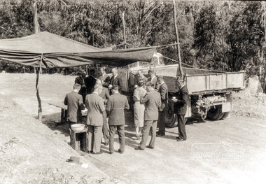
Photograph, Country Road Board members having morning tea just south of St Andrews, Heidelberg-Kinglake Road, 1962, 1962
Black and white photograph of Council and Country Road Board group with truckheidelberg kinglake road, kinglake road -
 Eltham District Historical Society Inc
Photograph, House extension, 6 (Lot 7) Bird Street, Eltham, c.1963, 1963c
Three black and white photographs of 1960s house extension at 6 Bird Street, Eltham 1. West side extension added. Built by Allan Giles. Dug holes for stumps, inspected by Council prior to photograph. Allan had his own plumber and electrician - all Masons 2. Glen Giles 4 years being born 1959, additional room built by his father Allan Giles 1960s (c.1963) 3. West side extensionbird street, houses, bayles, gwen baker -
 Eltham District Historical Society Inc
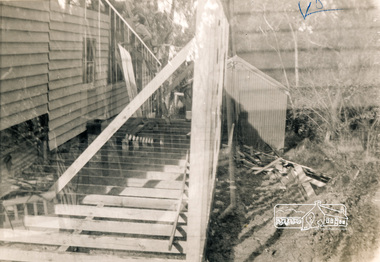
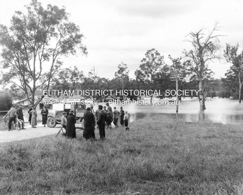
Photograph, Main Road, Eltham South, corner of Falkiner Street, flooded by the Diamond Creek, 1934
View of the Diamond Creek flooding across Main Road looking towards Eltham at intersection with Falkiner Street; a Council truck blocking Main Road, Eltham Lower Park on right, Eltham Park Tea Rooms (later Ansell and Muir) on left fooded. The bridge can just be seen on far right centre.Black and white photographmain road, eltham south, ansell and muir, diamond creek (creek), eltham park, eltham park tea room, falkiner street, floods, floodwater -
 Eltham District Historical Society Inc
Photograph, Old Bridge, Kaylock's Crossing, Brougham Street, Eltham, c.1895
Brougham Street was created in Josiah Holloway's 1851 subdivision of Little Eltham. It was one of several east-west streets shown on the subdivision plan as crossing the Diamond Creek. The western part was named Wellington Street on the subdivision plan but was later changed to conform with the name of the eastern part as acknowledgement of the continuity of the street. It is not known when the first bridge was constructed in Brougham Street however it was certainly mentioned at Council’s meeting of 2 June 1884 as being in a dangerous state of repair. This photo (c.1895) of an old bridge shows a very low-level simple log girder bridge crossing the creek at a right angle and so the approaches involved bends in the road alignment. This bridge was generally known as Kaylocks Bridge or Kaylock’s Crossing after the owner of the adjoining land. It was most likely built from around the mid-1850s, or a crossing of some fashion established as Richard George Kaylock, butcher of Little Eltham and his wife Emily Ann settled there in 1854. His property was in Wellington Street (now Brougham Street) and apparently extended across the Diamond Creek. The land on the western side of the creek was farmed, the house being on the eastern side. Kaylock's Bridge formed part of the original coach road to Eltham and in 1922 was described as an "old rustic bridge". Its low level and insubstantial construction made it susceptible to flood damage, necessitating frequent closures until repairs could be carried out. In September 1922, Council called for tenders for a new timber bridge to be constructed at Kaylock’s crossing. An engineering assessment carried out for the Council by Macleod Consulting at the time of the replacement suggested that the construction details indicate that it was in the 1900s, however this dating could possibly have been the result of numerous repairs undertaken over the years to flood damage. The tender was awarded to Mr Weller of Kangaroo Ground who commenced work in February 1923 on a higher-level timber trestle bridge. Work was slowed due to illness of the contractor and the accidental death of a man in March 1923 following the collapse of the bank after he had jumped into a hole that had just been blasted. The bridge was completed around July 1923 at which point the old structure was pulled up, marking what was described in the ‘Advertiser’ newspaper as the passing of an old and well-loved landmark in the district. In April 1924 the approach to Kaylocks bridge was washed away during the heavy flooding that destroyed the Main Road bridge. The western side was repaired, and an extra span was added to the eastern side using timber from the destroyed Main Road bridge. The bridge was again severely damaged four months later in August 1924 When a lack of finances delayed repairs to the Bridge Street bridge in 1931 (also referred to as Obelisk Bridge at the time), traffic had to detour via Brougham Street for some time. Local residents feared that the Bridge Street bridge might never reopen. Kaylocks Bridge was constantly subject to damage by floods. In the 1934 flood it was submerged by two feet of water. In more recent times the bridge was again severely damaged by flooding and repairs made. A new bridge and adjoining footbridge were constructed in 2009. Part of a slide show presentation "Bridges & Waterways of the Shire" by Russell Yeoman to the 13 September 1989 Society meeting. The presentation included slides of historic photos from the Shire of Eltham Pioneers collections as well as several recent views.Photo of earliest known crossing of the Diamond Creek at brougham StreetPostcard photo printbrougham street, eltham, wellington street, kaylocks bridge, bridge, diamond creek (creek) -
 Eltham District Historical Society Inc
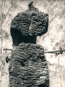
Photograph, George W. Bell, Diamond Creek, 1969, 1969
Canberra Times (ACT : 1926 - 1995), Thursday 9 January 1969, page 1 A day of century heat, 13 KILLED IN VICTORIAN FIRES ...About thirty houses and a public hall were destroyed by fire in the township of Diamond Creek. The group officer of the Diamond Creek Fire Brigade, Mr Tom Harrington, said tonight that he thought it was a "miracle" that no-one lost their lives in the fires. A relief centre for the homeless was set up by the Diamond Valley Shire Council. Mr Harrington said that the first fire call in the town was received at 10.45 am. "Within 20 minutes there were five more fires and it seemed like the whole town was alight", he said. "It was a chaotic day. All our best plans for fighting the fires became disorganised. "As 60-mile-an-hour winds swept fires through different parts of the town many fire fighters were unable to get from one fire to another. ," Black and white photograph of charred fire remnant Diamond Creek 1969diamond creek, fire, george w bell collection, bushfire, charred, burnt timber -
 Eltham District Historical Society Inc
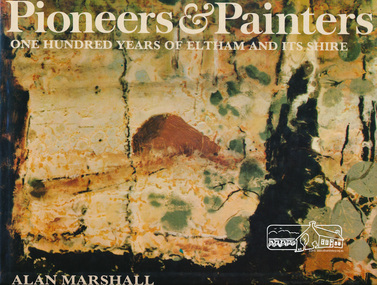
Book, Alan Marshall (1902-1984), Pioneers & painters : one hundred years of Eltham and its shire, 1971
Jacket painting by Clifton Pugh. "Eltham Shire is a well known as a district in which a large number of painters, sculptors, potters, writers and other creative people, The early settlers were, for the most part, resourceful and far-sighted ; the present residents are no less so. Mention the name Eltham and many things spring to mind ; conservation ; the integration of architecture with the environment ; mud-brick buildings; Montsalvat - the list is endless. In 1971, the centenary of the Shire's birth, the Council felt that the publication of a history would fittingly mark more than a century of achievement.." - Dust jacket. Contents: The Beginning Kangaroo Ground Education at Kangaroo Ground The Days of Gold Queenstown Panton Hill The Pioneer Women Christmas Hills and Yarra Glen Eltham Education at Eltham and Research Kinglake Hurstbridge by Sheila Ferguson Montmorency and Lower Plenty The New Way of Life Old Identities Eltham in modern times Educationalists and Writers Earth building in Eltham Early Painters by Peter Glass Painters Today by Peter Glass Warrandyte painters and Potters by Peter Glass Wildlife Present day This book provides a comprehensive history of the former Shire of Eltham and its first one hundred years. Hardback Book with Dust Jacket - 144 p. : illus. (part col.) ; ISBN 0170019489 eltham, alan marshall, shire of eltham, clifton pugh -
 Eltham District Historical Society Inc
Book, Eric J. Martin, Access to heritage buildings for people with disabilities / prepared by Eric J. Martin, 1997c
Paperback; 64 p. : ill. ; 30 cm.ISBN 0646349783buildings -
 Eltham District Historical Society Inc
Book, Graeme Davison, What makes a building historic? / Graeme Davison, 1986
Paperback; 12 p. : ill. ; 25 cm.ISBN 0730601366buildings -
 Eltham District Historical Society Inc
Book, Peter Marquis-Kyle et al, The illustrated Burra Charter : making good decisions about the care of important places / Peter Marquis-Kyle & Meredith Walker, 1992
Paperback; 84 p. : ill., ports ; 30 cm.ISBN 064612403buildings, monuments, social customs, art, culture, conservation