Showing 20892 items
matching eltham-hotel
-
 Tarnagulla History Archive
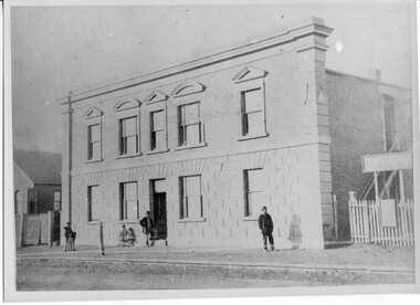
Photograph of Company's Hotel, Tarnagulla, Company's Hotel, Tarnagulla, late 19th Century (original image)
Murray Comrie Collection. Monochrome photograph depicting Company's Hotel, Tarnagulla which was formerly located in Commercial Road. This photograph is a fair copy of an older original, probably made in the late 1960s. tarnagulla, buildings, burstall hall, company's hotel, hotels, council chambers -
 Buninyong & District Historical Society
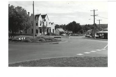
Photograph - B/W photograph, Roundabout - intersection of Learmonth and Warrenheip Streets Buninyong. Background Crown Hotel, 1995
Shows major intersection in mid 1990's. Record of intersection in mid 1990'sB/W photograph of intersection of Learmonth and Warrenheip Streets Buninyong. Crown Hotel centre background, bottle shop next door, and corner shop visible on right.buninyong, streeetscape, buiulding, crown hotel, corner shop -
 Camberwell Historical Society
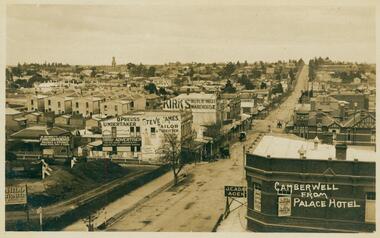
Postcard - Photo postcard, Camberwell from Palace Hotel, 24-01-1909
Frazer and Vallance Photo Post Card. Origin and writer of postcard unknown.Frazer and Vallance photo postcard showing view looking south from the Palace Hotel, Camberwell Junction. Writing on back of postcard, dated Jan 24th 1909. Writing on back of postcard which reads: My Dear Bella, I received your card on Wednesday and was quite pleased to get it, thank-you very much. This is the place I am living in at present - I rather like it, it is quite a change after Yack. Alex. P.S. has Hill any intentions of coming down next month. I have not saw L.C. yet. I never go out that way. Rember me to all at home. -
 Buninyong & District Historical Society
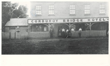
Photograph - Photograph of Original Photograph, Corduroy Bridge Hotel and Post Office, 1906, 1988
Building historyB/W photo of original photo of Corduroy Bridge Hotel, High St. Clarendon, circa 1906, shows Clarendon Post Office and members of Brown family.corduroy bridge hotel, clarendon, high street, clarendon post office -
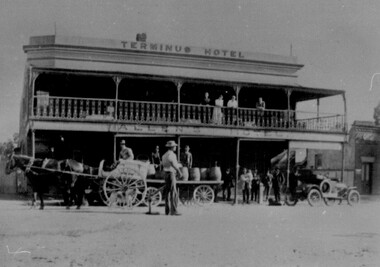 Wodonga & District Historical Society Inc
Photograph - Terminus Hotel, Wodonga 15 February 1910
The Terminus Hotel, Wodonga was built by James Thompson Hatch in 1873, the same year the railway reached Wodonga from Melbourne. It was named due to its close proximity to the railway terminus. It was sold to Messrs George Day and Kenneth McLennan of Albury. It was first licenced to J.G. Morton in January 1874. Annie Allen, from Ireland, took over as licensee of the hotel containing 14 rooms in 1879, after she and her husband, George James Allen, purchased it. In 1887 they added a new wing on the south boundary of the property next to Peter McLean’s store at 81 Sydney Road. The architects for the new wing were Gordon and Gordon. A billiard room, a dining room, and 18 other rooms were added on the vacant block of land between the Hotel and the Bank of Victoria. A balcony 6 feet wide was added on the north side. Included in the plans was the latest patent elevator, later known as a dumb waiter. Allen died in 1889 aged 52, and Annie Allen continued to run the Terminus. She later married John G. Haldon and was licensee of the hotel until December 1898 when the licence was transferred to William Carkeek. Carkeek, from Cornwall, arrived in the colony around 1860 and is considered one of the founders of Tallangatta. In November 1903, the license was transferred to Daniel Crawford, then in 1906 it was transferred to Mr Stephen Carkeek. In 1916 it passed into the hands of Mr H. W. Allen of Rutherglen, son of Mr George James Allen. On 1st June 1998 the Terminus Hotel was destroyed by fire. Estimates of damage range from between a conservative $750,000 to as high as $2 million. The remains of the building were demolished in 1999.The Terminus Hotel was one of the earliest hotels in Wodonga with clear links to the establishment of the railway line. It was an important business and meeting place for social gatherings.In 1879, the Terminus Hotel was purchased by Annie and George Allen.The hotel was advertised as a two storey brick building with bar, large dining and four rooms on the ground floor, all and commodious cellar. Upstairs a large parlour and 13 bedrooms. There was also a four-roomed weatherboard cottage, a blacksmith's shop and other buildings. The Allens had about 20 years of ownership, with Annie continuing to hold the licence under her new married name of Annie Haldon after George had died in 1889. In 1888, the Allens undertook extensive additions and renovations. Annie remained as the proprietor of the building until her death in 1904, but the business was leased to William Carkeek in December 1898. The building was eventually auctioned as part of the finalising of Annie's estate in 1909.Across top of building "TERMINUS HOTEL" Beneath balcony "ALLEN'S HOTEL"hotels wodonga, businesses wodonga, terminus hotel wodonga -
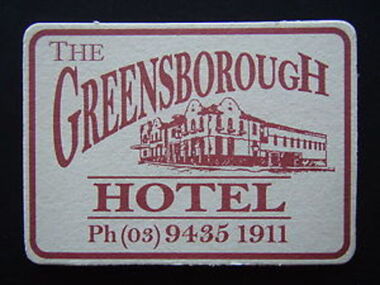 Greensborough Historical Society
Coaster - Digital Image, Greensborough Hotel, 1980s
Drink coaster from the Greensborough Hotel, 1980sPart of a collection of miscellaneous advertisements for businesses in Greensborough and surrounding areas.Digital copy of coaster, white card, red text.main street greensborough, greensborough hotel -
 Malmsbury Historical Society
Photograph (Item), "After Photo Of Commerc Hotel Clean Up Railway G/Shed,O/Shop", Malmsbury ca1988
People - Orr Street Buildings - Commercial Hotel -
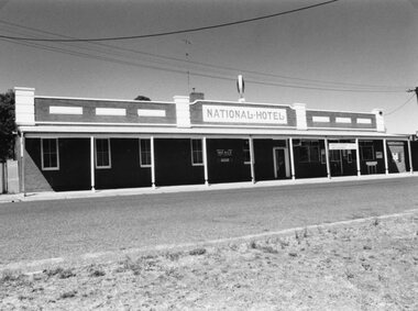 Stawell Historical Society Inc
Photograph, National Hotel in Wakeham Street Stawell c2000
National Hotel Wakeham Street Stawell c2000 stawell -
 Stawell Historical Society Inc
Photograph, Templar's House in Glenorchy which becomes the Wimmera Hotel
Templar's House in Glenorchy. Wimmera Hotel Glenorchy -
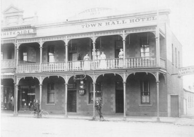 Stawell Historical Society Inc
Photograph, Town Hall Hotel with Ladies on Balcony c 1900
Town Hall Hotel c1900 Ladies on Balconystawell -
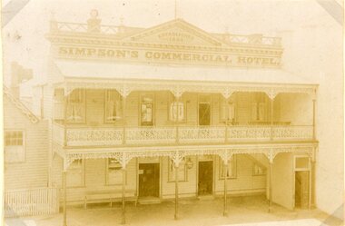 Stawell Historical Society Inc
Photograph, Simpsons Commercial Hotel in Main Street Stawell
Simpsons Commercial Hotel Main Street Stawellstawell -
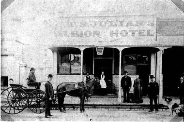 Stawell Historical Society Inc
Photograph, Earles Albion Hotel Stawell 1890's
Earles Albion Hotel Stawell 1890'sstawell -
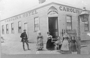 Stawell Historical Society Inc
Photograph, Hotel Carolina in Upper Clemes Street Stawell
Hotel Carolina. Upper Clemes Street Stawell.stawell -
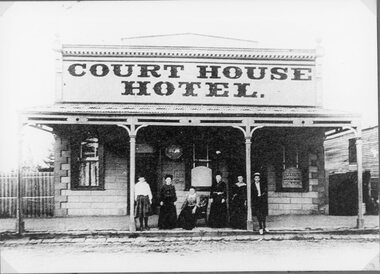 Stawell Historical Society Inc
Photograph, Court House Hotel in Patrick Street Stawell
Court House Hotel. Patrick St. Stawellstawell -
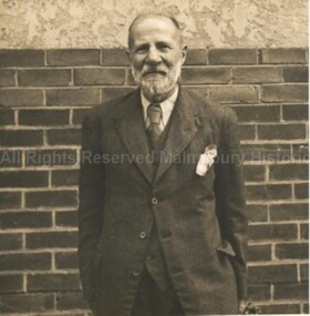 Malmsbury Historical Society
Photograph (Item), "B/W Mr Edward Townsend C1930, Malms Hotel", Malmsbury c1930s
People - "Townsend, Edward" Buildings - Malmsbury Hotel? -
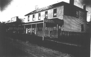 Malmsbury Historical Society
Photograph (Item), B/W Photo Duggans Malmsbury Weatherboard Hotel Pre 1940, Malmsbury pre1940
People - Duggan Family Buildings - Malmsbury Hotel -
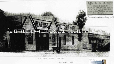 Whittlesea Historical Society Inc.
Photograph - Copy, Keating's Victoria Hotel, Epping, c.1900
Keating's Victoria Hotel, Epping c.1900A4 black and white copy of photograph from newspaper article also digital image on HD.epping, keating family, victoria hotel epping, keating's hotel, keating's victoria hotel -
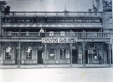 City of Ballarat Libraries
Postcard - Card Box Photographs, Carlyon's Club Hotel
Also known as Carlyon's Family & Commerical Hotel.carlyon's club hotel, building, hotel, commerical -
 Stawell Historical Society Inc
Photograph, Greens Creek Hotel & Post Office c1907
Greens Creek Hotel & Post Office c1907stawell -
 Stawell Historical Society Inc
Photograph, Wakeham Street Stawell including the National Hotel
Street Scene - Wakeham Street (National Hotel)stawell -
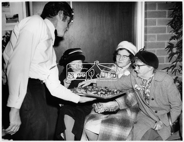 Eltham District Historical Society Inc
Photograph, Early Residents' Reunion, Shire of Eltham Centenary Celebrations, 8 Aug 1971
Three unknown women wearing hats enjoying an horderve with unknown waiter at the early residents reunion as part of the centenary celebrations for the Shire of Eltham in August 1971. The event was held in the West Riding Hall, Henry Petrie Community Centre, Montmorency. This photo forms part of a collection of photographs gathered by the Shire of Eltham for their centenary project book, "Pioneers and Painters: 100 years of the Shire of Eltham" by Alan Marshall (1971). The collection of over 500 images is held in partnership between Eltham District Historical Society and Yarra Plenty Regional Library (Eltham Library) and is now formally known as 'The Shire of Eltham Pioneers Photograph Collection.' It is significant in being the first community sourced collection representing the places and people of the Shire's first one hundred years.Digital imagesepp, shire of eltham pioneers photograph collection, centenary celebrations, shire of eltham, shire of eltham centenary, early residents, early residents' reunion, horderve, henry petrie community centre montmorency -
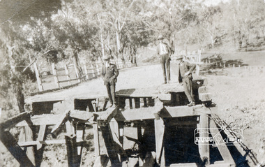 Eltham District Historical Society Inc
Photograph, Main Road Bridge, Eltham, c.1924
The wooden Main Road Bridge was substantially damaged in the 1924 flood and was replaced with a concrete structure Pages from a scrapbook belonging to Heather Jenkins (nee Sargeant) who lived as a child in the Police Residence at 728 Main Road, Eltham in the 1920s.This photo shows the flood damage to the bridge structure or the dismantling of the bridge post 1924 flood. Heather Sargeant was the daughter of Constable W.C. Sargeant, the local police officer in residence at Eltham, 1922-1927Glued on a brown paper scrapbook page (torn from scrapbook) with 9 black and white/sepia photos of varying sizes, 1 newspaper clipping and handwritten captions in ink.On verso in pencil "Const. W.C. Sargeant 1922-1927 - see Police list"heather jenkins (nee sargeant), eltham, police residence, constable w.c. sargeant, main road, main road bridge -
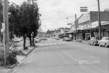 Eltham District Historical Society Inc
Photograph, Looking north along shopping centre, Main Road, Eltham, February 1968, Feb 1968
East side shops including Thompson's Pharmacy, Clinton's Hardware, Eltham Real Estate, N.H. Baxter Estate Agent, Willet's Food Centre, Bank of N.S.W., Chemist, Milk Bar, and Caltex Service Station on the corner with Luck Street. In February 1968 an unknown person took a series of photos from the Eltham Hotel at Pitt Street heading north along Main Road through the shopping centre to just north of Elsa Court covering the length of the section of Main Road which was duplicated shortly thereafter. Shows the condition and environment of the streesscape of Main Road, Eltham immediately prior to the duplication between Pitt Street and Elsa Court through the shopping centre. Also shows a number of shops and businesses that operated at that time.Black and white photographduplication, eltham, main road, shopping centre, bank of n.s.w., willet's food centre, thompson's pharmacy, n.h. baxter estate agent, milk bar, luck street, eltham real estate, clinton's hardware, caltex service station, chemist, clinton's hardware, eltham, eltham real estate, luck street., main road, milk bar, n.h. baxter estate agent, tt, thompson's pharmacy, willet's food centre, duplication, chemist -
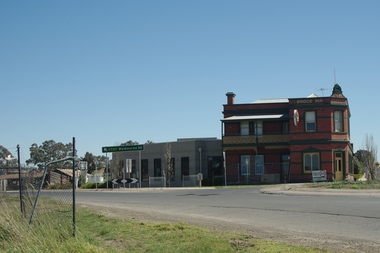 Greensborough Historical Society
Photograph - Digital Image, Bridge Inn Hotel Mernda 2018, 25/07/2019
In 2018 GHS members visited Turner's Bakery in Mernda for lunch and continued on to visit historic sites remaining in the Mernda area. This photograph shows the Bridge Inn Hotel Mernda, established 1891. The hotel is still operating in the 21st century.Mernda is an area of rapid modern growth with a few remaining historic buildings dating from the 19th century.Digital copy of colour photographmernda, bridge inn hotel mernda, mernda historic sites, hotels mernda -
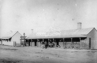 Eltham District Historical Society Inc
Slide - Photograph, Hotel de France, Panton Hill, c.1890
Three men and a dog stand on the verandah of the Hotel de France in Panton Hill, built about 1864. The hotel, store and post office were all under the same roof and were burned down in a fire in September 1904. This photo forms part of a collection of photographs gathered by the Shire of Eltham for their centenary project book,"Pioneers and Painters: 100 years of the Shire of Eltham" by Alan Marshall (1971). The collection of over 500 images is held in partnership between Eltham District Historical Society and Yarra Plenty Regional Library (Eltham Library) and is now formally known as the 'The Shire of Eltham Pioneers Photograph Collection.' It is significant in being the first community sourced collection representing the places and people of the Shire's first one hundred years.Digital image scanned from slide of print Slide (negative and print missing noted 20/11/1997)hotel de france, panton hill, shire of eltham pioneers photograph collection -
 Eltham District Historical Society Inc
Photograph, Liz Pidgeon, Heritage Excursion; East of Eltham, 6 Sep 2014, 20 May 2017
Newsletter No. 218, September 2014 September Excursion - East of Eltham Walk In Newsletter No. 197, March 2011, there was a brief history of Crown Allotment 15 Section 5 Parish of Nillumbik (CA 15) a parcel of land of a quarter of a square mile extending from Eucalyptus Road to Reynolds Road at the eastern extremity of Eltham. From the 1940s it was known as Stokes orchard. In later years it has been subdivided for residential purposes but leaving significant areas as power line and water supply reserves and bushland reserves that are habitat for the threatened For our excursion on 6th September we intend to walk through CA 15 to a bushland reserve east of Reynolds Road. The walk will traverse the boundary between suburban Eltham and the non-urban areas to the south and east. This is a pleasant walk through residential areas and bushland. Along the way we will discuss the early and more recent history of CA 15 as well as local natural history and geology. This walk is about 3.5 km in length and will take 2 to 2.5 hours. It will start at 2pm at the corner of Eucalyptus Road, Pitt Street and Nyora Road.Born Digitaleltham east, eltham district historical society, heritage excursion, activities, nyora road, reynolds road, gum tree road reserve, diosma road, stokes orchard, eucalyptus road -
 Eltham District Historical Society Inc
Photograph, Liz Pidgeon, Heritage Excursion; East of Eltham, 6 Sep 2014, 20 May 2017
Newsletter No. 218, September 2014 September Excursion - East of Eltham Walk In Newsletter No. 197, March 2011, there was a brief history of Crown Allotment 15 Section 5 Parish of Nillumbik (CA 15) a parcel of land of a quarter of a square mile extending from Eucalyptus Road to Reynolds Road at the eastern extremity of Eltham. From the 1940s it was known as Stokes orchard. In later years it has been subdivided for residential purposes but leaving significant areas as power line and water supply reserves and bushland reserves that are habitat for the threatened For our excursion on 6th September we intend to walk through CA 15 to a bushland reserve east of Reynolds Road. The walk will traverse the boundary between suburban Eltham and the non-urban areas to the south and east. This is a pleasant walk through residential areas and bushland. Along the way we will discuss the early and more recent history of CA 15 as well as local natural history and geology. This walk is about 3.5 km in length and will take 2 to 2.5 hours. It will start at 2pm at the corner of Eucalyptus Road, Pitt Street and Nyora Road.Born Digitaleltham east, eltham district historical society, heritage excursion, activities, nyora road, reynolds road, gum tree road reserve, diosma road, stokes orchard, eucalyptus road