Showing 3220 items
matching road map
-
 Whitehorse Historical Society Inc.
Letter - Correspondence, Vermont, 15/11/1987 12:00:00 AM
etter from Grace Gibbs to Keith Rooney containing information on the history of Vermont and hand-drawn sketch map of local orchards and farms - also information on Vermont Seventh Day Adventists, now Ringwood Seventh Day Adventist Church.Letter from Grace Gibbs to Keith Rooney containing information on the history of Vermont and hand-drawn sketch map of local orchards and farms - also information on Vermont Seventh Day Adventists, now Ringwood Seventh Day Adventist Church.etter from Grace Gibbs to Keith Rooney containing information on the history of Vermont and hand-drawn sketch map of local orchards and farms - also information on Vermont Seventh Day Adventists, now Ringwood Seventh Day Adventist Church.vermont, gibbs, clare, rooney, keith, vermont seventh day adventist church, ringwood seventh day adventist church -
Whitehorse Historical Society Inc.
Map, Gill's Springfield Road Estate, 1950?
... , Spencer Jackson. Gill's Springfield Road Estate Map Map ...Plan of subdivision for Gill's Springfield Road Estate, former orchard, 16 lots.Plan of subdivision for Gill's Springfield Road Estate, former orchard, 16 lots. Reprinted by Real Estate Agent, Spencer Jackson.Plan of subdivision for Gill's Springfield Road Estate, former orchard, 16 lots. land subdivision, norway avenue, blackburn, springfield road, blackburn, beverley crescent, blackburn, kevin avenue, blackburn, kerr street, blackburn, bordeaux avenue, blackburn, gill's estate, orchards, spencer jackson -
Whitehorse Historical Society Inc.
Map, State Electoral Districts, 1937
Map showing [Victorian] State Electoral Districts, Metropolitan, 1937.Map showing [Victorian] State Electoral Districts, Metropolitan, 1937. Scale: 40 chains to the inch.Map showing [Victorian] State Electoral Districts, Metropolitan, 1937.electoral boundaries, melbourne, elections -
Whitehorse Historical Society Inc.
Pamphlet, Blackburn Creeklands, 1990
Pamphlet produced by City of Nunawading on Blackburn Creeklands with photos and map.Pamphlet produced by City of Nunawading on Blackburn Creeklands with photos and map.Pamphlet produced by City of Nunawading on Blackburn Creeklands with photos and map.blackburn creeklands, blacks walk, kalang park, furness park -
 Whitehorse Historical Society Inc.
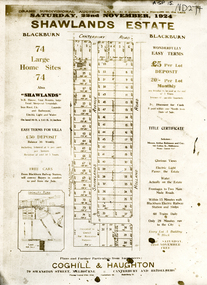
Document, Shawlands Estate, 22/11/1924 12:00:00 AM
Notice of Sale of land Holland Road and Canterbury RoadNotice of Sale of land Holland Road and Canterbury Road Blackburn Original in Haughton Maps LaTrobe LibraryNotice of Sale of land Holland Road and Canterbury Road land subdivision, canterbury road, blackburn south, holland road, shawlands avenue, coghill & haughton, shawlands estate, haughton map collection, state library of victoria. latrobe library -
 Whitehorse Historical Society Inc.
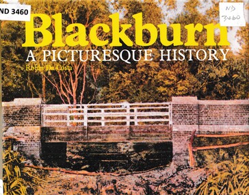
Book - Chronicle, Blackburn, A Picturesque History, 1978
A chronicle of Blackburn with photographs, diagrams and maps from the 1850's onwards.A chronicle of Blackburn with photographs, diagrams and maps from the 1850's onwards.non-fictionA chronicle of Blackburn with photographs, diagrams and maps from the 1850's onwards.open air school blackburn no3850, blackburn., morton park, traveller's rest hotel, blackburn lake sanctuary, blackburn creek hotel, blackburn road blackburn, blackburn post office, blue moon fruit co-operative ltd, blackburn railway station, pioneers, gordon crescent blackburn, lake road blackburn, goodwin george augustus, morton thomas richards burrowes, st johns anglican church blackburn, blackburn methodist church, blackburn church of christ, blackburn primary school no 2923, blackburn scout group 1st, blackburn and district tree preservation society, g.f. fankhauser -
 Whitehorse Historical Society Inc.
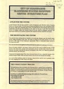
Pamphlet, City of Nunawading Blackburn Station Shopping Centre structure plan, 1990
Map of land use precincts, draft structure plan including overall strategic goals of Blackburn Station Shopping Centre. Also traffic managementMap of land use precincts, draft structure plan including overall strategic goals of Blackburn Station Shopping Centre. Also traffic management.Map of land use precincts, draft structure plan including overall strategic goals of Blackburn Station Shopping Centre. Also traffic managementblackburn station shopping centre, land use -
Whitehorse Historical Society Inc.
Map, Schwerkolt historical homestead, 10/04/2002 12:00:00 AM
Plans of Schwerkolt Cottage and Museum Complex.Plans of Schwerkolt Cottage and Museum Complex. Consists of master plan, details and site analysis, and accompanying letter, scale 1:500.Plans of Schwerkolt Cottage and Museum Complex. schwerkolt cottage & museum complex., plans -
Whitehorse Historical Society Inc.
Map, Municipality of Nunawading, c1950
Plan No 234, compiled and photo-lithographed at the Melbourne and Metropolitan Board of Works under the direction of G.R. McGowan, Chief Surveyor.Plan No 234, compiled and photo-lithographed at the Melbourne and Metropolitan Board of Works under the direction of G.R. McGowan, Chief Surveyor. Covers the area each Side of Canterbury Road from Orchard Grove to Vernon Street. Includes detail of creeks.Plan No 234, compiled and photo-lithographed at the Melbourne and Metropolitan Board of Works under the direction of G.R. McGowan, Chief Surveyor. blackburn south, gardiners creek, blackburn, blackburn creeklands -
Whitehorse Historical Society Inc.
Map, Shire of Blackburn and Mitcham, c1920
Map of the Shire of Blackburn and Mitcham (Sheet 2) with gas and sewered areas coloured.Map of the Shire of Blackburn and Mitcham (Sheet 2) with gas and sewered areas coloured. Scale 8 chains = 1 inch.Map of the Shire of Blackburn and Mitcham (Sheet 2) with gas and sewered areas coloured.shire of blackburn and mitcham, sewerage and sanitation, gas supply -
Whitehorse Historical Society Inc.
Map, Nunawading, c1850
Early map of Nunawading, Bulleen and part of Boroondara areas.Early map of Nunawading, Bulleen and part of Boroondara areas.Early map of Nunawading, Bulleen and part of Boroondara areas.shire of nunawading, bulleen, boroondara -
Whitehorse Historical Society Inc.
Map, City of Nunawading, n.d
Map of the City of Nunawading with streets and railway stations namedMap of the City of Nunawading with streets and railway stations named Scale 1 mile = 3.75 inMap of the City of Nunawading with streets and railway stations named city of nunawading, maps -
Whitehorse Historical Society Inc.
Map, City of Nunawading, c1980
Map of the City of Nunawading with list and location of 47 schools.Map of the City of Nunawading with list and location of 47 schools. Scale 1 mile = 3.75 inMap of the City of Nunawading with list and location of 47 schools. city of nunawading, maps, schools -
Whitehorse Historical Society Inc.
Map, Shire of Blackburn and Mitcham, c1920
Hand drawn map of the Shire of Blackburn and MitchamHand drawn map of the Shire of Blackburn and Mitcham (Sheet 2) Scale 4 chains = 1 inchHand drawn map of the Shire of Blackburn and Mitchamshire of blackburn and mitcham, tunstall, nunawading, mitcham, maps -
Whitehorse Historical Society Inc.
Document, Andreas Fritsch, 1992
History and maps of the brick quarry opened by Andreas Fritsch in Nunawading in 1856.History and maps of the brick quarry opened by Andreas Fritsch in Nunawading in 1856. His quarry was between Burwood Road and Mahoneys Reserve, enclosed with a letter from Geoff Ford, historian and pottery collector to Mrs B. Gray. Information on history taken from Niall Brennan's 'History of Nunawading'.History and maps of the brick quarry opened by Andreas Fritsch in Nunawading in 1856. clay, fritsch, andreas, ford, geoff, gray, beryl, pottery -
Whitehorse Historical Society Inc.
Map, Aerial photograph, c1950
Arial photo of Vermont South and Burwood East, Middleborough Road, Burwood Highway, Springvale Road, Highbury Road and environs.Aerial photo of Vermont South and Burwood East, Middleborough Road, Burwood Highway, Springvale Road, Highbury Road and environs.Arial photo of Vermont South and Burwood East, Middleborough Road, Burwood Highway, Springvale Road, Highbury Road and environs.vermont south, burwood east, aerial photographs -
 Whitehorse Historical Society Inc.
Document, Orcharding and the Blue moon Cooperative
... Whitehorse Historical Society Inc. 2-10 Deep Creek Road ...Typescript history of the Blue Moon Cooperative LtdTypescript history of the Blue Moon Cooperative Ltd also a map indicating the destinations to which fresh fruit was shipped by the Blue Moon Group of companies.Typescript history of the Blue Moon Cooperative Ltdcool stores, blue moon fruit co-operative ltd -
Whitehorse Historical Society Inc.
Document, McGlone's Estate Mitcham, 1/04/1921 12:00:00 AM
Copy of pamphlet of McGlone's Estate, Mitcham auctioned April 1921.Copy of pamphlet of McGlone's Estate, Mitcham auctioned April 1921. 24 allotments. Bordered by Whitehorse Road, McGlone Street, Station Street and Mitcham railway line and station. Original in Haughton maps, LaTrobe Library.Copy of pamphlet of McGlone's Estate, Mitcham auctioned April 1921. land sales, auctions, mcglone, john, mcglone, elizabeth, whitehorse road, mitcham, mcglone street, mitcham, station street, mitcham, mitcham railway station, haughton map collection, state library of victoria. latrobe library -
Whitehorse Historical Society Inc.
Legal record - Land Title, Musk Street, Blackburn
Land Titles referring to No. 1 Musk Street, BlackburnLand Titles referring to No. 1 Musk Street, Blackburn : 1. Vol. 542 Fol. 108222, James William Barnes, 1872; 2. Vol. 1877, Fol. 375367, Freehold Investment and Banking Company of Australia Limited, 1886; 3. Transfer 1507851 to John Thomas Williams, 1932; 4. Vol. 8109 Fol. 997 William Henry Rogers, 1955, with Plan of Subdivision CP 21670; 5. cadastral map, AMA zone 55, Sep 2000.Land Titles referring to No. 1 Musk Street, Blackburn musk street, blackburn, no. 1, maple street, blackburn, lawson street, blackburn, elder street, blackburn, barnes, james william, freehold investment and banking company of australia ltd, springfield road, blackburn, whitehorse road, blackburn, barnes estate -
Whitehorse Historical Society Inc.
Map, Burwood Road, Box Hill City, 1952
... Mitcham melbourne maps burwood road burwood parer street elgar ...Country Roads Board survey of Burwood Road, Burwood between Central Avenue and Elgar Road. Includes details of fencing, nature of buildings. With penciled additions to 1957.Country Roads Board survey of Burwood Road, Burwood between Central Avenue and Elgar Road. Includes details of fencing, nature of buildings. With penciled additions to 1957.Country Roads Board survey of Burwood Road, Burwood between Central Avenue and Elgar Road. Includes details of fencing, nature of buildings. With penciled additions to 1957.maps, burwood road, burwood, parer street, elgar road, cromwell street, ireland street, central avenue burwood, scott grove, somers street, gilmour street, evans street, edwards street, mills road -
Whitehorse Historical Society Inc.
Map, Victorian Railways, Blackburn to Ringwood, 1919
Schematic plan of rail line with notes of all signals and junctions. Signed by Gus. Ballard, Chief Engineer of Ways of Works.Schematic plan of rail line with notes of all signals and junctions. Signed by Gus. Ballard, Chief Engineer of Ways of Works.Schematic plan of rail line with notes of all signals and junctions. Signed by Gus. Ballard, Chief Engineer of Ways of Works.victorian railways, blackburn railway station, tunstall railway station, nunawading railway station, mitcham railway station, ringwood railway station -
Whitehorse Historical Society Inc.
Map, Dandenong Ranges area. Sheet 7, c1957
... Whitehorse Historical Society Inc. 2-10 Deep Creek Road ...Detailed map covering area from Mitcham and Vermont to Ringwood and Heathmont.Detailed map covering area from Mitcham and Vermont to Ringwood and Heathmont. Shows streets, block boundaries, buildings, railway and creeks. Note says prepared from State Aerial Survey, April 1954 and Cadastrial Survey information July 1956.Detailed map covering area from Mitcham and Vermont to Ringwood and Heathmont. maps, mitcham, vermont, ringwood, heathmont -
Whitehorse Historical Society Inc.
Map, Railway map of Victoria, 1912
... Whitehorse Historical Society Inc. 2-10 Deep Creek Road ...Detailed map of railways in Victoria including adjacent areas of New South Wales.Detailed map of railways in Victoria including adjacent areas of New South Wales. Also shows 'principal coach routes'. On verso map of suburban lines with eastern line as far as Croydon and Bayswater. key numbers on map linked to pages of a timetable.Detailed map of railways in Victoria including adjacent areas of New South Wales.maps, railways -
 Whitehorse Historical Society Inc.
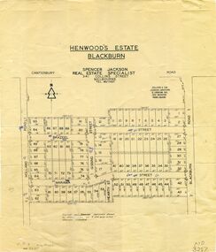
Map, Henwoods Estate, Blackburn
Plan of subdivision in Blackburn SouthPlan of subdivision in Blackburn South between Holland Road and Blackburn Road. Estate advertised by Spencer Jackson, 341 Collins Street.Plan of subdivision in Blackburn South land subdivision, henwoods estate, blackburn south, holland road, brazeel street, marama street, blackburn road, gissing street, hearty street -
Whitehorse Historical Society Inc.
Map, Burwood Road, Box Hill City, 15/02/1952 12:00:00 AM
... Road, Box Hill City Map Map ...Plan of subdivision of ten blocks in Burwood Road, Burwood.Plan of subdivision of ten blocks in Burwood Road, Burwood between Milford Avenue and Station Street. Marked as Survey Plan No 5441.Plan of subdivision of ten blocks in Burwood Road, Burwood. land subdivision, burwood road, burwood, milford avenue, burwood, central court, burwood -
Whitehorse Historical Society Inc.
Map, Burwood Road, Box Hill City, 15/02/1952 12:00:00 AM
... Whitehorse Historical Society Inc. 2-10 Deep Creek Road ...Plan of subdivision of 19 blocks in Burwood Road, Burwood.Plan of subdivision of 19 blocks in Burwood Road, Burwood between Greenwood Street and Middleborough Road. Marked as Survey Plan No 5442.Plan of subdivision of 19 blocks in Burwood Road, Burwood. land subdivision, burwood road, burwood, greenwood street, burwood, middleborough road, burwood -
Whitehorse Historical Society Inc.
Map, Facilities provided for you, 1970
Map of the City of Nunawading showing main roads and reserves with numbers indicating location of Halls, Infant Welfare Centres, Elderly Citizens Clubrooms and other major Council facilities. Route of proposes Healesville Freeway marked.Map of the City of Nunawading showing main roads and reserves with numbers indicating location of Halls, Infant Welfare Centres, Elderly Citizens Clubrooms and other major Council facilities. Route of proposes Healesville Freeway marked.Map of the City of Nunawading showing main roads and reserves with numbers indicating location of Halls, Infant Welfare Centres, Elderly Citizens Clubrooms and other major Council facilities. Route of proposes Healesville Freeway marked.city of nunawading, maps, maternal and child health centres, senior citizens centres, healesville freeway, parks and reserves -
Whitehorse Historical Society Inc.
Map, Melbourne Metropolitan Area Base Map series. Sheet 214, c1960
... Whitehorse Historical Society Inc. 2-10 Deep Creek Road ...Map showing northern section of the City of Nunawading together with parts of Shire of Doncaster and Templestowe.Map showing northern section of the City of Nunawading together with parts of Shire of Doncaster and Templestowe. Shows roads, creeks, block numbers and contours at 5 feet vertical increments. Note on map: 'prepared ... from State Aerial Survey, January 1957 and Cadastral Survey information February 1959'.Map showing northern section of the City of Nunawading together with parts of Shire of Doncaster and Templestowe. maps, city of nunawading, shire of doncaster and templestowe -
Whitehorse Historical Society Inc.
Map, Burwood Road, Box Hill City, 15/02/1952 12:00:00 AM
... Mitcham melbourne maps burwood road burwood andrews street ...Detailed map of subdivision along the north side of Burwood Road, Box Hill between Station Street and Middleborough Road.Detailed map of subdivision along the north side of Burwood Road, Box Hill between Station Street and Middleborough Road. Shows many block owners, types of buildings, nature of fencing. Marked as 'Survey Plan No 5440'.Detailed map of subdivision along the north side of Burwood Road, Box Hill between Station Street and Middleborough Road. maps, burwood road, burwood, andrews street, greenwood street, tennyson street, middleborough road, station street -
Whitehorse Historical Society Inc.
Map, Melbourne Metropolitan Planning Scheme. Map No 39, c1950
... Whitehorse Historical Society Inc. 2-10 Deep Creek Road ...Map of central Melbourne showing planning zones with gardens and principal buildings marked.Map of central Melbourne showing planning zones with gardens and principal buildings marked.Map of central Melbourne showing planning zones with gardens and principal buildings marked.maps, city of melbourne, city of fitzroy, city of south melbourne, city of collingwood