Showing 110054 items matching "roads"
-
 Kew Historical Society Inc
Photograph - 'Butleigh Wooton', 867 Glenferrie Road, John T Collins, 1979
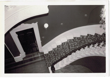
in 1882 Thomas Maidment paid the Society of Jesus £5,750 for nine allotments along Barkly Road (now Glenferrie Road). Maidment, who had arrived in Australia from the Glastonbury district in England in 1858, owned and managed a number of sheep stations in Victoria and subsequently became an '... eminently respectable ...' member of District society. In 1883 the Rate Books list Maidment's land in Barkly Road as the 'Buxton Hill Estate' and it was given an N.A.V. of £90, while in the following year his property attracted an N.A.V. of £160, suggesting that substantial improvements were taking place. Maidment's two-storey mansion, named 'Butleigh Wooton' after his birth-place in England, was completed in 1885 and was given an initial N.A.V. of £420. While Maidrnent is recorded as the owner of the building until at least 1896, Jane Maidment, his wife, continued the family ownership of the twenty-six roomed house with its extensive grounds until at least 1910. (Sanderson P. City of Kew Urban Conservation Study Vol 2)Butleigh Wooton is a substantial two storeyed house built in the Italianate style common in the 1880s. Its walls are rendered and it has limited applied decoration that includes brackets to the eaves line and engaged ionic columns under a broken pediment over the front entrance. The bowed window unit is of particular distinction and is not at all typical of this type of building. This interior by John T Collins is a view of the staircase from the first floor landing. (Sanderson P. City of Kew Urban Conservation Study Vol 2)Reverse: "JOHN COLLINS / 11 Anderson Road / Hawthorn East, 3123 / Film 395 Exposure 27A / Kew / Butleigh Wooton / Looking down on stairs / 8-4-79thomas maidment, butleigh wooton, 867 glenferrie road -- kew (vic.) -
 Kew Historical Society Inc
Photograph - 'Butleigh Wooton', 867 Glenferrie Road, John T Collins, 1979
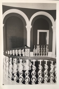
in 1882 Thomas Maidment paid the Society of Jesus £5,750 for nine allotments along Barkly Road (now Glenferrie Road). Maidment, who had arrived in Australia from the Glastonbury district in England in 1858, owned and managed a number of sheep stations in Victoria and subsequently became an '... eminently respectable ...' member of District society. In 1883 the Rate Books list Maidment's land in Barkly Road as the 'Buxton Hill Estate' and it was given an N.A.V. of £90, while in the following year his property attracted an N.A.V. of £160, suggesting that substantial improvements were taking place. Maidment's two-storey mansion, named 'Butleigh Wooton' after his birth-place in England, was completed in 1885 and was given an initial N.A.V. of £420. While Maidrnent is recorded as the owner of the building until at least 1896, Jane Maidment, his wife, continued the family ownership of the twenty-six roomed house with its extensive grounds until at least 1910. (Sanderson P. City of Kew Urban Conservation Study Vol 2)Butleigh Wooton is a substantial two storeyed house built in the Italianate style common in the 1880s. Its walls are rendered and it has limited applied decoration that includes brackets to the eaves line and engaged ionic columns under a broken pediment over the front entrance. The bowed window unit is of particular distinction and is not at all typical of this type of building. This interior by John T Collins is a view of the staircase from the first floor landing. (Sanderson P. City of Kew Urban Conservation Study Vol 2)Reverse: "JOHN COLLINS / 11 Anderson Road / Hawthorn East, 3123 / Film 395 Exposure 21A / Kew / Butleigh Wooton / Railing at head of stairs / 8-4-79thomas maidment, butleigh wooton, 867 glenferrie road -- kew (vic.), john t collins -
 Whitehorse Historical Society Inc.
Article, A House of character, 1990
When the Boyle farm was subdivided Len Boyle built this clinker brick home.When the Boyle farm was subdivided Len Boyle built this clinker brick home. In 1880 a youthful Mrs Boyle planted a pencil pine tree on the property. This tree still stands today in the garden of 359 Canterbury Road. This house is now for sale.When the Boyle farm was subdivided Len Boyle built this clinker brick home. boyle home, canterbury road, forest hill, no 359, boyle, len -
 Kew Historical Society Inc
Photograph - Civic event in Stradbroke Park, 1976
Stradbroke Park. Extent: Kilby Road to Harp Road at Burke Road. Historical Documentation: 1851 - Portion 91 purchased by Edward Glynn; 1888 - The Harp of Erin Estate (which included Section 91) offered for sale; 1896 - The area now known as Stradbroke Park was bisected by a creek that flowed from the Yarra via Hay's Paddock (q.v.) and extended through to Burke Road; 1943 - W.D. Birrell, Town Clerk of Kew, proposed that the creek be filled and a reserve created; 1954 - Entire area designated as 'open space' and named 'Stradbroke Park'. The line of the creek that ran through the Park created a further reserve on the north side of High Street, now known as 'Harrison Reserve'. Existing Condition: The park is largely of mown grass that has mature trees set into it It is possible that a number of these are remnant of the original vegetation, while there are also a number of exotic trees introduced, particularly at the northern end of the park. The southern end is dominated by playing fields. (Source: Sanderson, P 1988. Kew Conservation Study)Colour photographic positive (with colour degradation) of sporting teams at a civic event in Stradbroke Park in Kew East in May 1976. The event was officiated by the Mayor of Kew, Cr Alan Hutchinson. Stradbroke Park is situated on the western boundary of Kew and bordered by Burke and Harp Roads.stradbroke park, cr alan hutchinson, team sports -- kew (vic.) -
 Halls Gap & Grampians Historical Society
Photograph - B/W, C 1920s
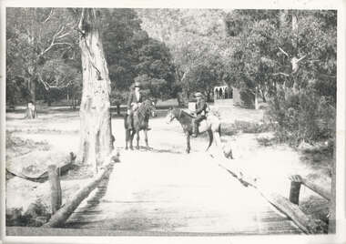
The Stoney Creek dray bridge. Stoney Creek has been bridged a number of times on school road since the creek was re-routed in the early 1900s. A dray bridge was built C 1910 by local residents, which stood them in good stead for more than a decade. This bridge was replaced by a higher timber structure. Image two is a story from 1906 relating to Marshall White and his family trying to recross Delley's bridge after finding the Stoney Creek dray bridge washed away.Photo of two men on horseback on a wooden bridge with low log railing. A shelter can be seen in the background and there are thick trees surrounding the road.structures, bridges -
 Orbost & District Historical Society
book, Johnson, Brenda, The Orbost Story 1959 to 1966, after 2000
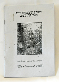
This story was written by Brenda Johnson and details her time in Orbost from 1959 -1966 settling on land at Lake Road in Newmerella.This book is a useful and interesting reference tool on life in Newmerella in the mid 20th century.A thin stapled paperback book of 31 pp. It is titled "The Orbost Story 1959 to 1966 Lake Road Newmerella Victoria". The cover is shiny silver with black print. In the centre is a black/white photograph of the block with numbers ( 2 3 ?) carved into a tree. There is a Land Rover in the background.Stapled inside back cover - "Bob Johnson" with telephone details and email address.newmerella-history johnson-brenda rural farming -
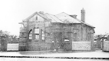 Surrey Hills Historical Society Collection
Photograph, Surrey Hills Post Office
The post office opened at this location in 1912. It was demolished in 2000. Post office history in the area: Until 1883 when the railway came through to Surrey Hills, this was essentially a rural community of scattered farms. Land subdivisions soon occurred along the railway line and limited postal services followed soon after, although a ‘permanent’ home for the post office was two decades away. George Sim Junior is acknowledged as our first postmaster; he opened a post office on 1 October 1884 in his father’s general store at 619-621 Canterbury Road, a few doors down from the Surrey Hills Hotel on the corner of Union Road. Over the next 20 years, the Surrey Hills Post Office moved several times into temporary, shared accommodation – in 1889 into Woodhead’s Corner Store at 364 Canterbury Road; then in 1895 to No 376, Hansen’s Exchange Building, part of Hansen’s Terrace (demolished) and in 1901 to 109 Union Road, on the corner of Windsor Crescent. Following Federation in 1901, the new Commonwealth Government established the Postmaster-General's Department to provide postal services to the nation. Many of the post offices constructed in the following years reflected a growing sense of Australian pride and nationalism. It was 1914 when building commenced on the ‘purpose-built’ post office at 609 Canterbury Road, Surrey Hills. Described as “a polychromatic Federation Freestyle building”, it served as the local post office for nearly 85 years until sold by the Commonwealth Government in c1999, after which the post office moved to the current, less prominent site at 100 Union Road. For nearly 10 years under private ownership, the building was successfully adapted for use as the base for two businesses, Gargoyles and Dragons and later the Surrey Sculpture Studio, and fortuitously the historic integrity of the building was maintained. However although renovated in the 1990's, structurally sound and of historic significance, it was not protected under local or commonwealth heritage legislation and was demolished soon after sale. This is an early image of a demolished building which should have been protected. In 1991, when the City of Camberwell conducted a heritage study, (which still informs the basis of the City of Boroondara’s heritage guidelines for this part of the municipality,) the post office was owned by the Commonwealth Government. As such, it could not be considered for heritage listing by the local authorities. Some years later, the Commonwealth and Australia Post rather belatedly recognized not only that post offices have heritage and social value, but also that the architecture of post offices as community buildings is important. A heritage management scheme was developed for the buildings they own or control under the Environment Protection and Biodiversity Act 1999. Unfortunately, the Surrey Hills Post Office had been sold and demolished before this was finally enacted in 2004. Black and white image, perhaps from a post card, of Surrey Hills post office at 609 Canterbury Road. The building is flanked by a picket fence. There is a woman, a dog and a man in front of the entrance. The man is in uniform - possibly a postal employee.post offices, canterbury road, businesses, surrey hills post office, surrey sculture studio, gargoyles and dragons -
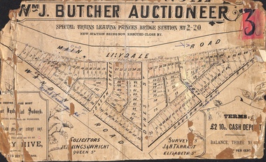 Ringwood and District Historical Society
Poster - Land Sale, Wm J. Butcher, Auctioneer - Albert Park Estate, Ringwood - c.1890
Central section of land sale subdivision advertisement glued to heavy cardboard backing. Photocopied SLV image of original advertisement shows map of 117 allotments for sale in Main Lilydale Road (later Old Lilydale Road), Wandin Road (later Mount Dandenong Road), Joseph Street, Dynes Street, Albert Street (later Wyrunga Street) and Government Road (later Carcoola Road), Ringwood East.Solicitors - Jenningw & Wright, Queen Street. Surveyors - J.&H. Tarrant, Elizabeth Street. Terms £2 10s cash deposit, balance three years at six per cent. -
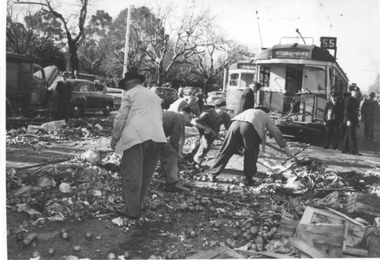 Melbourne Tram Museum
Photograph - Collision with a fruit truck - St Kilda Road, The Herald, 8/2/1953
Black and white photograph showing the result of a collision between possibly a W5 class tram, running a route 55 service in St Kilda Road, at Domain Junction. The front cabin of the tram has been sheared off, which it is designed to do. There is another tram behind the damaged one. A driver, conductor and an Inspector are in the photo while workmen clear up the mess. Photo by the Herald Sun 8/2/1953.Yields information about a collision between a truck and tram at Domain Junction during 1953.Photograph with hand written notes on rear and stamps on the rear.In ink "No. 2 - Tram & Vegetable truck Collision on St Kilda Road, Melbourne 8/2/53" and The Herald Sun copyright stamp.trams, tramways, collision, domain junction, route 55 -
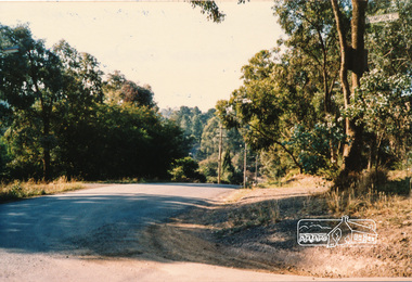 Eltham District Historical Society Inc
Photograph, Thompson Crescent area, Research
Three colour photographs of roads in the Thompson Crescent area, Research 1. Reynolds Road looking south from Thompson Crescent North 2. Reynolds Road/Thompson Crescent South 3. Reynolds Road/Thompson Crescent North, Researchthompson crescent, reynolds road, research -
 Ringwood and District Historical Society
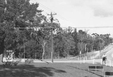
Photograph, Intersection of Tortice Drive, Old Warrandyte Road and Warrandyte Road 1981
Written on back of photograph, "19/6/81. Intersection of Tortice Drive, Old Warrandyte Road and Warrandyte Road." -
 Ringwood and District Historical Society
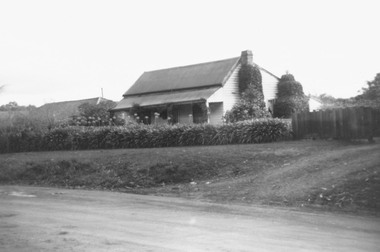
Photograph, Old house, Old Warrandyte Road, Ringwood, nearly opposite Quamby Road, 1978
Written on back of photograph, "Old house, Old Warrandyte Road, nearly opposite Quamby Road, June 1978". -
 Ringwood and District Historical Society
Photograph, Intersection of Warrandyte Road and Oban Road, North Ringwood. Looking south-east. 1981
Written on back of photograph, "18/4/81. Intersection of Warrandyte Road and Oban Road. Looking south-east". -
 St Kilda Historical Society
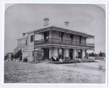
Photograph, Donald McDonald, Herford, 1872
Large residence on large elevated block for Frederick Christian Lange (1832-1888) and family in 1870. The architect Lloyd Tayler (1830-1900) designed it in an Italianate style. Over time adjoining allotments were purchased until the gardens covered nearly 15 acres. Lange was in partnership with Emil Thoneman trading under the name of Lange & Thoneman, merchants and general importers. Lange was also one of the local directors of the local Australasian directors for the Swiss Lloyd Marine Insurance Company. William Officer (1835-1913), pastoralist, bought the property from Lange in 1888 for 23,500 pounds. Following Officer's death the grounds were subdivided in 1914 and the house finally demolished in 1940. Noting the spelling difference, there is now a street named 'Hertford Street' very close to this location. black and white photograph copyAlma Road south west corner Lansdowne Road built for Federick C Lange (Merchant) Photo 1872 -
 St Kilda Historical Society
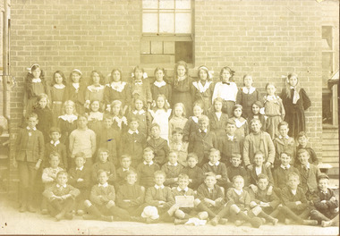
Photograph, St Kilda (Brighton Road)Primary School
Unable to read date in photograph but children's clothing suggests early 1900ssepia photograph mounted fair conditionSt Kilda (Brighton Road)Primary School. (?) Thomeson (?). 721 South Road, Moorabbin. Donated to the Historical Society. -
 Ringwood and District Historical Society
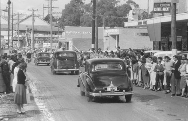
Photograph, City of Ringwood celebrations 1960
Black and white photograph (2 images)Image shows cavalcade of cars on Maroondah Highway moving east towards Wantirna Road with spectators lining road. -
Ringwood and District Historical Society
Photographs and pamphlet, Eastland Shopping Centre - pamphlet and Photos. C1980s, c.1980s
Pamphlet showing Eastland Shopping Centre and two photographs, one of Allan Robertson, City Engineer, and another with him and group looking at photo of the area.2 coloured photos and pamphlet about Eastland Shopping Centre +Additional Keywords: Robertson, AllanThe Road Ahead - we're on our way. -
 Ringwood and District Historical Society
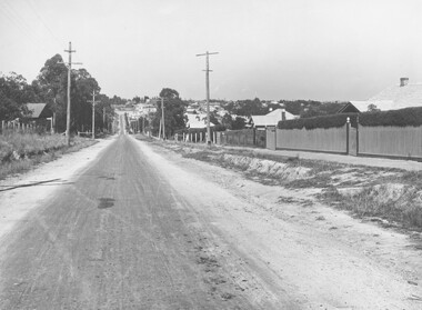
Photograph, Warrandyte Road (unmade Road). Ringwood. (undated, probably late 1960's/early 1970's)
Written on catalogue card, "Warrandyte Road". -
 Ringwood and District Historical Society
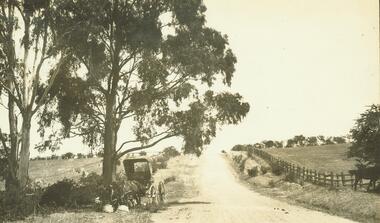
Photograph, Road to 'Quambee (undated)
With two horses attached to trap, feeding.Typed below photograph, "Road to 'Quambee'". -
 Bendigo Historical Society Inc.
Magazine - B2B BENDIGO'S OWN BUSINESS MAGAZINE, September 2004
Magazine, B2B Bendigo's Own Business Magazine, Business 2 Business, September 2004 , Price $2.20Newsprinters Pty.Ltd. Melbourne Road, Kialla.business, retail, advertising -
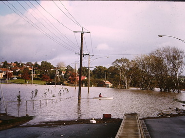
 St Kilda Historical Society
Photograph, Elwood floods 1989 - images collection, 7/02/1989
Glenhuntly Rd floods, February 1989colour photograph unmountedGlenhuntly Road floods Feb 89glenhuntly road, floods, 1989, elwood college, elwood secondary college, elwood -
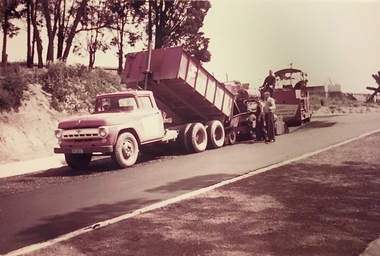 Kew Historical Society Inc
Photograph, Public Works, Road Construction, 1950s
An original photograph donated to the Kew Historical Society by the City's Engineering Department before the amalgamation of Kew into the City of Boroondara in 1994.While not all of the photographs are of Studley Park, Kew or East Kew, each photo provides a fine snapshot of the work of local government engineering departments of the period. They reveal they types of labour conducted, the techniques used and the equipment and machinery in the possession of the local government authority.Public works. Roadmaking machinery in the 1950s using a tip truck and other equipment. Inscription on reverse: "Road making. Date?" city of kew (engineering department), road construction maintenance -
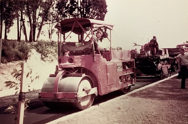 Kew Historical Society Inc
Photograph, Public Works, Road Construction, 1950s
An original photograph donated to the Kew Historical Society by the City's Engineering Department before the amalgamation of Kew into the City of Boroondara in 1994.While not all of the photographs are of Studley Park, Kew or East Kew, each photo provides a fine snapshot of the work of local government engineering departments of the period. They reveal they types of labour conducted, the techniques used and the equipment and machinery in the possession of the local government authority.Public works. Roadmaking in the 1950s using a steam roller. Inscription on reverse: "Road making. Date?" city of kew (engineering department), road construction building -
 Stawell Historical Society Inc
Book, Alexander Dumas, The Three Musketeers, 1949
Alan Tangey 83 Darlington Roadstawell education -
 Kew Historical Society Inc
Photograph - Flooding, Kilby Road, Kew, Ron Setford, 1974
Ron Setford and his wife Grace Setford lived in Tanner Avenue, East Kew, from c.1946 to c.1995. A keen photographer, he recorded the changing face of Kew over a 20 year period. Apart from 30 photographs of built structures and places in Kew dating from 1960 and 1961, 145 of his 35mm colour slides chronicle the development of the Eastern Freeway through the Yarra Valley over a five year period from c.1972 to c.1977. This important collection was donated to the Society by his granddaughter in 2025.This collection of 175 35mm slides is of local and statewide significance, owing to its subject matter, particularly the major development of road transport infrastructure during the 1970s with the construction of the Eastern Freeway. The photographer also took care to annotate and date most of his slides which enable the researcher to pinpoint temporal and spatial locations."Flood Kilby Road / May 74"ron setford, floods -- kew (vic.), kilby road -- kew (vic.) -
 Lakes Entrance Historical Society
Photograph - Hotel Ensay Victoria
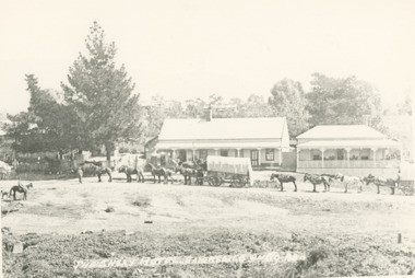
Black and white copy of photograph of hotel between Bruthen and Omeo with two horse drawn wagons in front, each wagon drawn by seven horses. Hotel on left with large pine tree and, residence on right, Ensay Victoria. Also an identical copyThe Ensay Hotel on Bairnsdale - Omeo Roadhotels, businesses -
 Lakes Entrance Historical Society
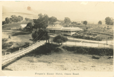
Postcard - Fregons Hotel Ensay Victoria
Black and white postcard of Fregons Hotel with suspension bridge across stream opposite, Ensay VictoriaFregon's Ensay Hotel Omeo Roadhotels, businesses -
 Ballarat Tramway Museum
Photograph - Black & White Photograph/s, 14/10/1973 12:00:00 AM
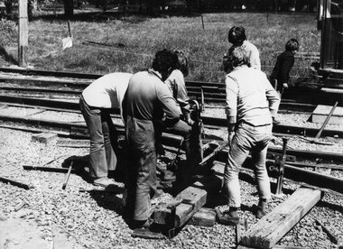
Yields information about the BTPS volunteers constructing the Trackwork at the BTPS depot in 1973 and who was undertaking the work.Black and white photograph of the BTPS workers boring a hole in the rail for a fish plate in the rails on No. 1 Road, 14 Oct. 1973. Featured in photograph are Bill Kingsley, Peter Reece, Richard Gilbert, Louis Melli and Peter Winspur. Photographer not known.In red ink on rear of photograph "Bill Kingsley, Peter Reece, Richard Gilbert, Louis Melli and Peter Winspur prepare the rail boring machine to bolt and plate the first rail on 1 road to the depot fan. Sun. 14 October 1973." tramways, trams, btps, depot, track laying -
 Bendigo Historical Society Inc.
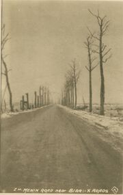
Postcard - ACC LOCK COLLECTION: MENIN ROAD NEAR BIRR :- X ROADS, 1914-1918
Postcard, WW1, B&W image of the Menin Road near Birr cross roads. Snow and burnt out trees on both sides of the road One copy Z10postcard, postcard, ww1, menin road, birr, france