Showing 13448 items matching "stations"
-
 Mordialloc College Alumni Association Inc (MCAA)
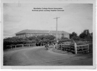
Photograph, 1954 Mordialloc-Chelsea High School and Station Street Railway Crossing Aspendale, 1954
Station Street Railway Crossing and Mordialloc-Chelsea High School. Photo courtesy of past student Heather Donovan nee Padman, -
 Port Melbourne Historical & Preservation Society
Photograph - Large wooden framed colour panorama photograph of Port Melbourne waterfront, Alison Kelly
Framed photograph. Taken from old Mission to Seamen building towards Station Pier. Shows Centenary Bridge and Abel Tasmanbuilt environment, centenary bridge, abel tasman, natural environment, maritime, piers and wharves -
Port Melbourne Historical & Preservation Society
Document - DVD, Public Records Office Victoria (PROV), Port Melbourne Police Station and Sergeant's Residence photos records and citation details, 1920s - 1930s
COPYRIGHT Public records Office Victoria DVD containing images of photographs relating to the Port Melbourne Police Station Sergeant's residencebuilt environment - civic, built environment - domestic, police, law, police station -
Port Melbourne Historical & Preservation Society
Audio - Oral History, Sylvia Gleeson, 29 May 1991
Interviewed by Pat Grainger at Sylvia's home at 98 Princes Street. Interview used in contributions to the book "They Can Carry Me Out" .Sylvia Gleeson discussing her life in Port Melbourne, particularly in relation to the operation of the kiosk on the East Wing Pier of Station PierDuration 01:03:07families, domestic life, piers and wharves - station pier, business and traders - kiosk, sylvia gleeson -
Clunes Museum
Book, GEOFF ARNOTT, REMEMBERING WEDDERBURN & NEIGHBOURING TOWNS
HISTORICAL RECOLLECTION OF WEDDERBURN AND SOUNDING TOWNSSOFT COVER BOOK, VARIOUSLY STREETSCAPE, RAILWAY STATION AND PUB IMAGES ON FRONT COVER, TOWN IN FOOD IMAGE ON BACK COVERnon-fictionHISTORICAL RECOLLECTION OF WEDDERBURN AND SOUNDING TOWNSwedderburn history, wedderburn townships -
 Linton and District Historical Society Inc
Photograph, Linton Railway Station and Stationmaster's House
Black and white photograph of platform and buildings at Linton Railway Station. The stationmaster's house can be seen on the right-hand side of the photograph.linton railway station, buildings, stationmaster's house linton -
Port Melbourne Historical & Preservation Society
Document - 2001 Calendar, Frank Gordon Estate Agents, c. 1920
Letterboxed in 2000Calendar for 2001 with colour-enhanced photo of Station Pier, steamers and the Ozone c1920, distributed by advertising estate agents Frank Gordonbusiness & traders - estate agents, piers and wharves - station pier, frank gordon & co -
 Linton and District Historical Society Inc
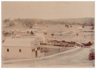
Photograph, Grenville Standard Building, Clyde Street, Linton
Sepia photograph of Grenville Standard building, with view of railway station and other buildings spread across open land at east of township."S E Surman".grenville standard [newspaper], buildings, linton railway station, clyde street linton -
Canterbury History Group
Map - Victorian Railways, Canterbury, Drainage Plan, cc1910
Drainage plan around Canterbury Station, Canterbury Road and Maling Road .5 pages of photocopies from the Public Record Officecanterbury, canterbury road, maling road, canterbury station, drainage, stormwater channels -
 Clunes Museum
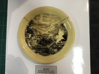
Artwork, other - PLATE
China Plate Smoke painted by R. Ford, Yellow China with Black, painting marked "Station Flat, Clunes" (RICHARD FORD)Trademark Johnson Bros Made in England Sticker marked "134"plate, richard ford -
 Port Melbourne Historical & Preservation Society
Photograph - Crowds, Station Pier, Port Melbourne, Roy Liebig, 1945
The donor's (Karen Bowden) grandfather - Roy Liebig (1897-1968) - took these photos in the 1940s. Karen, as administrtor of his estate, has extracted various photos and sent them to appropriate historical societies.A series of photographs taken by Roy Liebig in the 1940s Hard copy and digital. Crowds at Station Pier to see "Oranje" returning soldiersmaritime, war - world war ii, roy liebig, karen bowden, yarra river, oranje, piers and wharves - station pier -
Canterbury History Group
Photograph - Bronze Plaque in the ground in Theatre Place noting the original railway station entrance off Maling Road, Canterbury, Jan Pigot, 1994
Coloured photograph of Bronze Plaque in the ground in Theatre Place noting the original railway station entrance off Maling Road, Canterburycanterbury, maling road, theatre place, signs, canterbury railway station -
Canterbury History Group
Photograph - Street view of the enamelled picture plaque of the former Canterbury Station, Jan Pigot, 2004
Coloured photograph of the street view of the enamelled picture plaque of the former Canterbury Station on the brick wall at No. 111 Maling Road, Canterburycanterbury, maling road, theatre place, shops, signs, plaques -
Canterbury History Group
Photograph - Street view of the enamelled picture plaque of the former Canterbury Station, Jan Pigot, 2004
Coloured photograph of the street view of the enamelled picture plaque of the former Canterbury Station on the brick wall of No. 111 Maling Road, Canterburycanterbury, maling road, theatre place, shops, signs, plaques -
 Lakes Entrance Historical Society
Photograph - Broomes Maranui , Police Station Esplanade Lakes Entrance Victoria, 1938 c
In foreground is the stone wall beside the lake, concrete path and picnic table beside the Esplanade Lakes Entrance Victoria. c1938 Black and white photograph of a postcard showing Broomes Maranui Guesthouse with Police Station on the western side and the picture theatre on the eastern side.accommodation, transport -
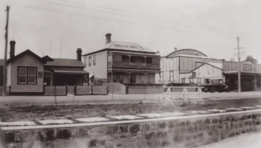
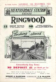 Ringwood and District Historical Society
Flyer, Subdivisional Land Auction Sale Brochures, Heatherdale Station Estate, Ringwood, Vic. - 1923 and 1924
Two double sided multi-folded pages advertising public auction sales of shop sites and residential allotments on Saturday, 15th December, 1923 and Saturday, 2nd February, 1924, including summary of local facilities, services and map showing layout of the estate. Includes a photograph depicting proposed site for first Heatherdale railway station and a panoramic view of Ringwood from the railway level crossing in Heatherdale Road. 1923 and 1924 flyers are identical except for the auction dates printed at the top.Subdivision includes Heatherdale Road, Molan Street, Yallourn Parade, Newman Street, and Madden Street. Agents - Knight & Harwood, 315 Collins Street, Melbourne, Phone 10615, 10616 Central, in conjunction with J.B. McAlpin, Opposite Railway Station, Ringwood. Phone Ringwood 7. Additional cardboard-backed copy of map includes later penciled sales notations for some blocks (VC 5801 refers). -
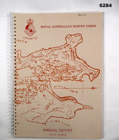 Bendigo Military Museum
Booklet - Royal Australian Survey Corps - Annual Report 1 Jul 87 - 30 Jun 88, Director of Military Survey -Army, 01.09.1988
Royal Australian Survey Corps Annual Report detailing Surveying and mapping activities 1 July 87 - 30 Jun 88. The first part of the report details the highlights during the period followed by Annexes A to J detailing Australian Map and Chart production. Annex A: 45 pages, Annex B: 1 page Aust Doppler Satelite Stations, Annex C: 1 page, Aust airborne Profile Recording, Annex D: 1 page Aust Aerial photography, Annex E: 1 page Aust Analytical Aerotriangulation, Annex F: 1 page Inertial Positioning System Network Traverses Fils Svy, Annex G: 1 page Global Positioning System Station/networks TI4100 Svy, Annex H: 1 page, Defence Cooperation Programme, Annex I 3 Pages RASvy Officer Manning, Annex J: 1 page RASvy ARES Manning Levels.Buff coloured light cardboard covers. Old map of Sydney Cove area printed in red/brown on front cover and Survey Corps Badge in red top left corner. "Map of the town of Sydney 1836" printed on back cover. A4 sized paper pages, 17 numbered pages plus, Annex A: 45 x pages, Annex B: 1 x page Aust Doppler Satellite Stations, Annex C: 1 x page, Aust Airborne Profile Recording, Annex D: 1 x page Aust Aerial photography, Annex E: 1 x page Aust Analytical Aerotriangulation, Annex F: 1 x page Inertial Positioning System Network Traverses Fils Svy, Annex G: 1 x page Global Positioning System Station/Networks TI4100 Svy, Annex H: 1 x page, Defence Cooperation Programme, Annex I 3 x pages RASvy Officer Manning, Annex J: 1 x page RASvy ARES Manning Levels.royal australian survey corps, rasvy, fortuna, army survey regiment, army svy regt, asr -
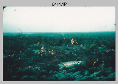 Bendigo Military Museum
Photograph - Royal Australian Survey Corps Surveyors in the Field – Northern Territory and Queensland, 1959 – 1960
This is a set of 10 photographs of surveyors and support staff in the field undertaking duties in the Northern Territory and North Queensland in 1959 – 1960. The surveyors were employed in the establishment of mapping and geodetic control. In this era surveyors used theodolites to observe horizontal and vertical angles and tellurometers to measure base line distances between survey stations. Laplace survey observations seen in Photo .1P was a series of precise observations carried out at geodetic survey stations to determine astronomic latitudes, longitudes and azimuths to achieve maximum precision in the survey network. Laplace observations were necessary in a geodetic network at every 6th survey station, however the National Mapping Council specified at this time the spacing would be ideally between 4-6 survey stations. The cairn shown in photo .4P was built by RASvy as a landmark over a trigonometric survey station. It was dismantled in 1960 to enable re-occupation and survey observations. It was not restored to the condition shown in the photo.This is a set of 10 photographs of surveyors and support staff in the field undertaking duties in the Northern Territory (NT) and Queensland (QLD) in 1959 – 1960. The photographs were printed on photographic paper and are part of the Army Survey Regiment’s Collection. The photographs were scanned at 300 dpi. .1) - Photo, colour, 1959. Tony Slattery occupying a Laplace survey station on a hill in the Mount Young area of the NT. .2) - Photo, colour, 1959. Surveyors’ camp in the Mount Young area of the NT, L to R: Spencer Snow and Tony Slattery. .3) - Photo, colour, 1959. Surveyors’ camp in the Peckman Hill area, near Katherine in the NT. .4) - Photo, colour, 1959. Cairn on Trig Hill, Borroloola, NT. Built by Spencer Snow, Tom Royle and Jack McCabe. .5) - Photo, colour, 1959. Survey party taking a break next to their Austin Champ vehicle, in transit between Katherine, NT and Wyndam WA. L to R: Tony Slattery, Dave Owens, John Van De Graff. .6) - Photo, colour, 1960. Surveyors’ camp between Mount Isa, QLD and Borroloola, NT. L to R: Pat Cox and John Van De Graff prepare their meal on an open fire. .7) - Photo, colour, 1960. Surveyor - Dennis Woods undertaking survey observations, using MRA1 tellurometer to measure base-line distances NW of Mount Isa, QLD. .8) - Photo, colour, 1960. Unidentified surveyors assessing recovery of their stalled Studebaker truck vehicle after attempting a water crossing in the NT. .9) - Photo, colour, 1960. Unidentified surveyor making batches of bread at a camp in the NT. Seen in the photo placing a lid with hot coals onto the camp oven. .10) - Photo, colour, 1960. Unidentified survey party occupying a survey station on a hill in the Mount near the Lawn Hill area, NW of Mount Isa, QLD. A MRA1 tellurometer to measure base-line distances appear on the right side of the photo. .9) - Photo, colour, 1960. Unidentified surveyors assessing recovery of their stalled Studebaker truck vehicle after attempting a water crossing in the NT. .10) - Photo, colour, 1960. Unidentified surveyor making batches of bread at a camp in the NT. Seen in the photo placing a lid with hot coals onto the camp oven. .1P to .10P annotated on back – personnel names, the year and the location. royal australian survey corps, rasvy, army survey regiment, asr, army svy regt, fortuna, surveying -
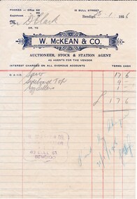 Bendigo Historical Society Inc.
Document - DONALD CLARKE COLLECTION: W.MCKEAN & CO. INVOICE
invoice dated 25/01/1956 fro Mr D. Clark, from W. McKean & Co., Auctioneer, Stock and Station Agent, for: saw £0.17.06 Sideboard Top £0.09.00 Egg Fillers £0.01.00 Invoice total £ 1.07.06. W. McKean & Co., Auctioneer, Stock and Station Agent, 53 Bull Street, Bendigo -
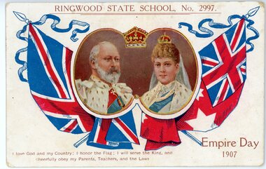 Ringwood and District Historical Society
Postcard, Ringwood State School No 2997- Empire Day 1907
Coloured Postcard"Written on back of Postcard" With complements Mr Hocking -Ringwood State School Grace Curry - Ringwood Railway Station. -
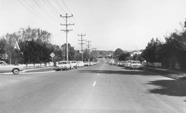 Ringwood and District Historical Society
Photograph, Bedford Rd. 1973. Looking towards Ringwood. Railway Station roof can be seen
Typed below photograph, "Bedford Rd. 1973. Looking towards Ringwood. Railway Station roof can be seen". -
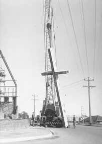 Ringwood and District Historical Society
Photograph, Cross erected outside new Methodist Church, Ringwood
Black and white photograph of mobile crane with large cross suspended from it. Man standing by crane.Typed below photograph, "Cross erected outside new Methodist Church Cnr. Station St. and Greenwood Ave." -
 Ringwood and District Historical Society
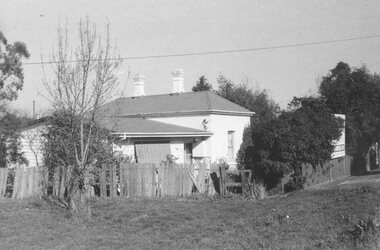
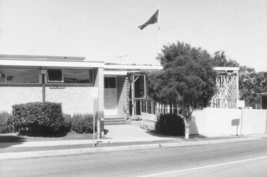
Photograph, Ringwood's first Police Station, 32 Mount Dandenong Road. (note room at left)
Written on back of photograph, "32 Mount Dandenong Road. Ringwood's first Police Station (note room at left). -
 Ringwood and District Historical Society
Photograph, Additions to R.S.L., Station Street 1973
Frame erectedWritten on back of photograph, "1973 = Additions to R.S.L., Station Street. Original building was Methodist Church Jubilee Hall". -
 City of Moorabbin Historical Society (Operating the Box Cottage Museum)
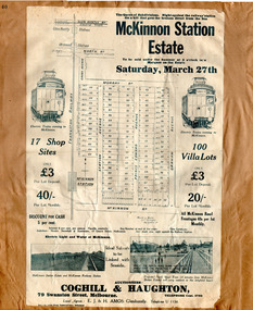
Flyer - The Railway Estate, McKinnon, 1920
At the end of World War One, there was a renewed interest in residential land and a number of estates opened up in the Municipality of Moorabbin.Example of the progress of the Municipality of MoorabbinAdvertising flyer for auction of real estate sales - plan of building blocks for saleMcKinnon Station Estate - 100 Villa lots & 17 business lots - Auction Saturday 27 March 1920mckinnon station estate, graham ave, prince edward ave, station street, mckinnon road, real estate, mckinnon, auction, moorabbin -
 St Kilda Historical Society
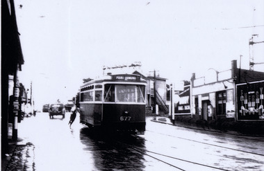
Photograph, Tram at Elsternwick Station level crossing, c. 1958
laminated black and white photograph (2 identical)Tram destination Point Ormond at Elsternwick Station when still a level crossing 195. Point Ormond 677. -
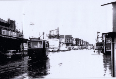 St Kilda Historical Society
Photograph, Elsternwick Station with level crossing, c. 1958
black and white photograph laminatedElsternwick Station with crossing gates beforethe bridge was built in 1958 tram, destination Point Ormond.The Rex. The Sun -
 Ringwood and District Historical Society
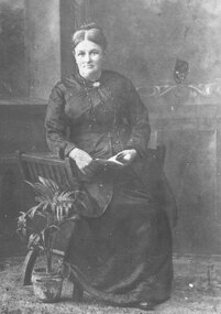
Photograph, Portrait - Catherine Rose (1858-1925) married James Keith Turnbull, Ringwood station master. c1890's
Black and white photograph of portrait.Written on back of photograph: "Catherine Rose (1858-1925) married James Keith Turnbull, Ringwood station master" -
 Ringwood and District Historical Society
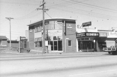
Photograph, South-West corner of entrance to Railway Station, Maroondah Highway, Ringwood - 4 March 1973
Black and white photograph Written on back of photograph: "West corner of entrance to railway station - 4 March 1973". CBC bank on corner. -
 Clunes Museum
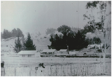
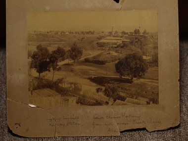
Photograph, CIRCA 1895 - 1900
PHOTOGRAPH OF SOUTH CLUNES BATTERY, SEPIA PHOTOGRAPH MOUNTED ON CARDBOARDHANDWRITTEN NOTES: LOOKING TOWARDS RAILWAY STATION, SOUTH CLUNES BATTERY FROM HILL ABOVE CREEK PARADElocal history, photography, photographs, mining