Showing 3220 items
matching road map
-
 Whitehorse Historical Society Inc.
Pamphlet, Heritage trails in Whitehorse - Blackburn, 2001
Heritage Trail through Blackburn - brochure with map and historical information and photographs of places of historical interest throughout Blackburn.Heritage Trail through Blackburn - brochure with map and historical information and photographs of places of historical interest throughout Blackburn. A heritage fund project supported by the Commonwealth.Heritage Trail through Blackburn - brochure with map and historical information and photographs of places of historical interest throughout Blackburn.walking trails, city of whitehorse, blackburn -
 Whitehorse Historical Society Inc.
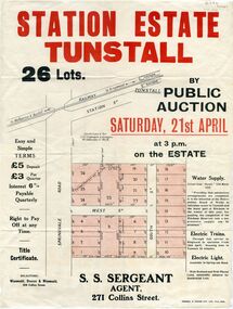
Pamphlet - Document, Station Estate Tunstall, 1923
Land Plan for auction of estate at Tunstall.Land Plan for auction of estate at Tunstall. Original in Haughton Maps, Latrobe LibraryLand Plan for auction of estate at Tunstall. auctions, station estate tunstall, s. s. sergeant (agent) -
 Whitehorse Historical Society Inc.
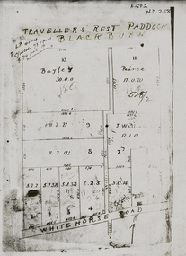
Pamphlet - Map, Travellers Rest Paddock
Map of Travelers' Rest Paddock, Blackburn subdivisionMap of Travellers Rest Paddock, Blackburn subdivision with frontage in Whitehorse RoadMap of Travelers' Rest Paddock, Blackburn subdivisionwhitehorse road, blackburn, travellers rest paddock, williams road, bayley, leonard sherwin, pearce, land subdivision -
Whitehorse Historical Society Inc.
Document, Australian Social History House Research Assignment, 1986
Social History of 2 Gordon Crescent, Blackburn,Social History of 2 Gordon Crescent, Blackburn, included - History of Blackburn, Architecture of the House and first owner, Thomas Richards Burrowes. Morton. Real Estate Brochures, Maps, Photos, Floor Plans.Social History of 2 Gordon Crescent, Blackburn, morton thomas richards burrowes, architecture -
 Whitehorse Historical Society Inc.
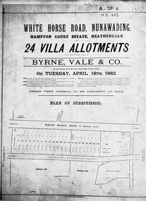
Document, Hampton Court Estate
Plan of subdivision Hampton Court EstatePlan of subdivision Hampton Court Estate Whitehorse Road, Nunawading 1882. Original in Vale Maps LaTrobe LibraryPlan of subdivision Hampton Court Estate hampton court estate, byrne vale & co. -
Whitehorse Historical Society Inc.
Map, Directory Maps of the County of Bourke, 1892
Directory maps of the County of Bourke, containing all the Parishes ...Directory maps of the County of Bourke, containing all the Parishes ... also a complete map of the Colony of Victoria, showing all the Counties, Parishes, Railways and stations to date, and the Mallee Blocks. Lithographed by G.S.B. Bonney for the Victorian Shire Map Company. Scale: 40 chains to the inch.Directory maps of the County of Bourke, containing all the Parishes ...maps, victoria. county of bourke, t.r.b. morton & son -
Whitehorse Historical Society Inc.
Pamphlet, Melbourne's water; a community problem, 1968
Collection of papers relating to Melbourne's future water needs by Leigh Blackburn with map extractsCollection of papers relating to Melbourne's future water needs by Leigh Blackburn with map extracts defining the area the author considers the most suitable for the development of future water resources and the dangers of the Lower Yarra Dam proposals.Collection of papers relating to Melbourne's future water needs by Leigh Blackburn with map extracts water supply, melbourne and metropolitan board of works, state rivers and water supply commission, lower yarra dam -
Whitehorse Historical Society Inc.
Document, List of schools in the city of Nunawading, 1969
List of schools in the City of Nunawading and hand drawn map showing locations.city of nunawading, schools -
 Whitehorse Historical Society Inc.
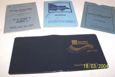
Book - State Savings Bank Books
Donor is a member of the Whitehorse Historical SocietyTwo State Savings Bank of Victoria bank books with blue cloth cover with map of Victoria embossed in dark blue. 139--153 Elizabeth Street branch 1956 (829444) 1960/68 (16616) Mitcham Branch. Plus state Savings Bank of Victoria Passbook cover, pale blue cardboard. Plus Travelers Cheques cover 1891-1999 State Bank Victoria. Very dark blue vinyl .The State Savings Bank of Victoriacommerce, banking -
 Whitehorse Historical Society Inc.
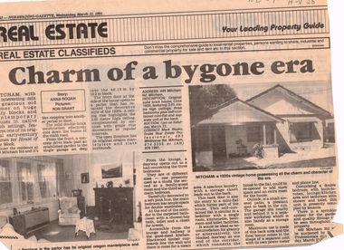
Article, Charm of a bygone era, 13/03/1991 12:00:00 AM
... Whitehorse Historical Society Inc. 2-10 Deep Creek Road ...Advertisement in Nunawading Gazette, 13 March 1991 for auction of 1920s houseAdvertisement in Nunawading Gazette, 13 March 1991 for auction of 1920s house at 449 Mitcham Road, Mitcham.Advertisement in Nunawading Gazette, 13 March 1991 for auction of 1920s houseauction maps, maps, plans -
Whitehorse Historical Society Inc.
Book, Sevenoaks Park, 1980 repr. 2004
A history of Jeffery Street Blackburn and surrounding area once known as Sevenoaks Park.A history of Jeffery Street Blackburn and surrounding area once known as Sevenoaks Park. Contains old maps and land titlesA history of Jeffery Street Blackburn and surrounding area once known as Sevenoaks Park. sevenoaks park, jeffery, mary ann, jeffery street blackburn, blackburn road blackburn, lake road blackburn, da costa, robin, burns, frank, satchwell, keith -
Whitehorse Historical Society Inc.
Map, City of Whitehorse, 2001
Key map of City of Whitehorse, showing parks and reserves, council and community facilities and services.Key map of City of Whitehorse, showing parks and reserves, council and community facilities and services.Key map of City of Whitehorse, showing parks and reserves, council and community facilities and services.libraries, child care centres, parks and reserves, senior citizens centres, maternal and child health centres, city of whitehorse -
Whitehorse Historical Society Inc.
Document, Melbourne's Valley of the Arts, 2002
Map, brochure and copy of 'Melbourne's Valley of the Arts Tourism Newsletter Jan 2002Map, brochure and copy of 'Melbourne's Valley of the Arts Tourism Newsletter Jan 2002Map, brochure and copy of 'Melbourne's Valley of the Arts Tourism Newsletter Jan 2002tourist attractions, map -
Whitehorse Historical Society Inc.
Article, Mitcham on the verge, 2000
Brief description of Mitcham - past and present, accompanied by small map and a table containing median house and flat prices.Brief description of Mitcham - past and present, accompanied by small map and a table containing median house and flat prices.Brief description of Mitcham - past and present, accompanied by small map and a table containing median house and flat prices.mitcham, city of whitehorse -
Whitehorse Historical Society Inc.
Document, F. S. Baker/ Yarra Hill country map, 1950s
Advertising leaflet for F. S. Baker, Mt. Pleasant Road Nunawading,Advertising leaflet for F. S. Baker, Mt. Pleasant Road Nunawading, Real Estate Agent c. 1950s, backed by Broadbent's Map no. 280, Yarra Hill CountryAdvertising leaflet for F. S. Baker, Mt. Pleasant Road Nunawading, broadbents, baker, f. s., mount pleasant road, nunawading, no. 20 -
Whitehorse Historical Society Inc.
Map, Blackburn Shopping Centre, 2006
Plan of Blackburn Shopping Centre c.1954, drawn by Bob Hoskins, showing businesses trading at that time.Plan of Blackburn Shopping Centre c.1954, drawn by Bob Hoskins, showing businesses trading at that time. Refer Tape NP2376 April 2001Plan of Blackburn Shopping Centre c.1954, drawn by Bob Hoskins, showing businesses trading at that time.blackburn shopping centre, hoskins furniture and floor coverings -
Whitehorse Historical Society Inc.
Map, State Electoral Map, 1926
State Electoral Map for 1926.State Electoral Map: Metropolitan and country areas, showing changes to electoral districts legislated in the Redistribution of Seats Bill 1926State Electoral Map for 1926.victoria, electoral boundaries -
 Whitehorse Historical Society Inc.
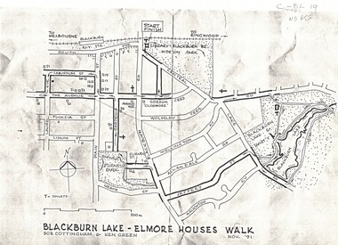
Map, Blackburn Lake - Elmore houses walk, 1/11/1991
... Whitehorse Historical Society Inc. 2-10 Deep Creek Road ...Map of Blackburn outlining a walk through the lake.Map of Blackburn outlining a walk through the lake. The route includes four Elmore houses.Map of Blackburn outlining a walk through the lake.maps, blackburn lake sanctuary, the avenue, blackburn, laburnum street, main street, gardenia street, blackburn road, gordon crescent -
Whitehorse Historical Society Inc.
Article, Art in bark, 2012
The Art in Bark state branch has displayed their mural of a map of the State of Victoria in eight panels.The Art in Bark state branch has displayed their mural of a map of the State of Victoria in eight panels. Col. photoThe Art in Bark state branch has displayed their mural of a map of the State of Victoria in eight panels. bark murals, art in bark association of australia, koonung cottage community house, gibson, robyn -
Whitehorse Historical Society Inc.
Map, Museum extension May 2002, 2002
Plan and elevation of extension to the Museum at Schwerkolt Cottage & Museum Complex May 2002.Plan and elevation of extension to the Museum at Schwerkolt Cottage & Museum Complex May 2002.Plan and elevation of extension to the Museum at Schwerkolt Cottage & Museum Complex May 2002.schwerkolt cottage & museum complex, extension -
 Whitehorse Historical Society Inc.
Map, Orchards 1922, 1922
1922 map showing orchards in Doncaster East, Blackburn, Mitcham, Tunstall, Ringwood, Vermont, East Burwood, Tally Ho.vermont orchards, tunstall, ringwood, blackburn, tally ho, east doncaster -
Whitehorse Historical Society Inc.
Map, Britannia Rise, 2012
Photos and plans of Britannia Rise.Photos and plans of Britannia Rise.Photos and plans of Britannia Rise.britannia rise', whitehorse road mitcham, no 569-571, mitcham railway station, eastlink, britannia mall, kenneth jones real estate -
Whitehorse Historical Society Inc.
Document, Blackburn Township Estate, 1906
110 business and residential sites for sale.110 business and residential sites for sale, Saturday 6th October 1906. Stamped by T.R.B. Morton, Financial and Estate Agent, 80 Swanston St. Melbourne.110 business and residential sites for sale.blackburn township estate, morton, thomas richards burrowes, haughton maps -
Whitehorse Historical Society Inc.
Map, City of Nunawading map, 1970s (post 1974)
Catchment area of Blackburn East Primary School.Catchment area of Blackburn East Primary School marked in texta on map of the City of Nunawading. Scale: 1 km:6 kmCatchment area of Blackburn East Primary School. city of nunawading, blackburn east primary school no. 4800 -
Whitehorse Historical Society Inc.
Map, Blackburn East Primary School
Plans of Blackburn East Primary SchoolPlans of Blackburn East Primary School (1)1957; (2) Master Plan ; (3) Master Plan 1973. (4) Scheme F: Staff and administrative facilities 1974, Scale 1/8:1'Plans of Blackburn East Primary Schoolblackburn east primary school no. 4800, master plan, admin facilities -
Whitehorse Historical Society Inc.
Map, Blackburn East Primary School
Proposed master plan 1955?Proposed master plan 1955? With Public Works Dept. detail survey 1979. Rolled map.Proposed master plan 1955? blackburn east primary school no. 4800, public works department -
Whitehorse Historical Society Inc.
Map, City of Nunawading Street and Block Map
City of Nunawading Street and Block map.City of Nunawading Street and Block map. Scale: 1:10,000. with enlargement, Canterbury Road South to Burwood Highway.City of Nunawading Street and Block map. canterbury road nunawading, burwood highway burwood east, city of nunawading -
Whitehorse Historical Society Inc.
Map, Blackburn East Primary School
Works Department detail survey.Public 1979. Rolled map. Works Department detail survey.Works Department detail survey.blackburn east primary school no. 4800, victoria. public works department -
Whitehorse Historical Society Inc.
Map, Map of Mitcham, 1916?
Copy of early map of Mitcham.Copy of early map of Mitcham showing main roads and large blocks of land with owners' namesCopy of early map of Mitcham. mitcham road mitcham, heatherdale road mitcham, whitehorse road mitcham, morton, william, ainger, f, morgan, r. r., harding, w, sergeant, r, mcclelland, john, wilson, w, cook, j -
Whitehorse Historical Society Inc.
Map, Melbourne Geological Map, 1937
Geological Map of Melbourne & Suburbs.Geological Map of Melbourne & Suburbs. Scale: 40 chains to 1 inch with inset 10 miles to 1 inch. Includes Municipal and Parish boundaries, railways and stations, electric tramways, cable tramways, Post Offices and State schools. Area bounded by Braybrook, Preston, Blackburn & Brighton. Printed on linen.Geological Map of Melbourne & Suburbs. melbourne, maps