Showing 2104 items
matching structures
-
 Moorabbin Air Museum
Manual (Item) - RAAF - Macchi MB326-H Aircraft Canopy Assy Structure MRN 30-31802-10
AAP 7297.001-3M -
Moorabbin Air Museum
Book (Item) - The Aircraft Engineer's Handbook No.1 , Airframe Structure And Controls Flying Instruments and Equipment
By W,J.C. Speller A.F.R.Ae.S -
Moorabbin Air Museum
Document - Design Manual Volume 2- Structures, Australian Aircraft Consortium
-
Moorabbin Air Museum
Drawing (Item) - Hudson Ambulance Conversion Stretcher Loading Hatch & Reinforcing Structure Looking Aft Drawing No.6
-
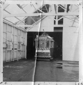 Ballarat Tramway Museum
Photograph - Black & White Photograph/s, 18/07/1972 12:00:00 AM
Demonstrates an aspect of the BTPS works on relocating trams ex the SEC depot in the nick of time - as the depot was being demolished. Shows the structure of the depot.Black and White photograph of Ballarat No. 38 inside the SEC depot, following the commencement of the demolition works prior to relocation to the BTPS depot, possibly on 18/7/1972, the day of its relocation.tramways, trams, moving trams, depot, sec depot, btps, tram 38 -
Moorabbin Air Museum
Manual (Item) - CA-31 Manuals - Canopy<>Fuselage structure, Front Fuselage & Cabin, Fuselage primary, Centre Fuselage, Fuselage
-
Moorabbin Air Museum
Booklet - Aircraft Sheetmetal Worker to: Aircraft Mechanic Structures, Aircraft Industry (Domestic Airlines Award) Award Restructuring Sampling Examination Notes
-
Moorabbin Air Museum
Document (Item) - Figures Depicting the Organisational Structure of CAC Management, 1973-1977, Commonwealth Aircraft Corporation Pty. Ltd. Organisation Chart
-
Moorabbin Air Museum
Booklet - Trade Structure of the RAF Electronic Engineering (Trade Group 2) Volume 2A. Trade Specification for Electronic Technician (Air), Ministry of Defence Electronic Engineering
-
Moorabbin Air Museum
Manual (item) - Nomad - series of folders on operations and structure of various components
-
Moorabbin Air Museum
Booklet - Forest Products Technical Notes No.1 Gluing Techniques for Timber Engineering Structures, The Division of Forest Products CSIRO
-
Moorabbin Air Museum
Document (Item) - 1964 Trade Structure Of The Royal Air Force Volume II Ground Signalling (Trade Group No.11)
AAP 3376A Vol.II -
Moorabbin Air Museum
Document (Item) - Various notes and correspondence, Jindivik Mk 4 work breakdown structure
-
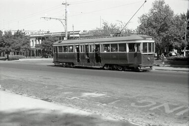 Ballarat Tramway Museum
Negative, Wal Jack, early 1950's
Yields information about tram services in Sturt St and the building structures.Negative and Digital images of the Wal Jack Ballarat Negative file of tram 39 in Sturt St at Dawson St. Tram has the destination of Mt Pleasant. In the background is the Golden City Hotel and the Harry Davies store.trams, tramways, drummond st nth, tram 39 -
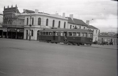 Ballarat Tramway Museum
Negative, Wal Jack, early 1950's
Yields information about tram services in Sturt St and Grenville St and the building structures.Negative and Digital images of the Wal Jack Ballarat Negative file of tram 39 entering Bridge St, crossing Grenville St after leaving Sturt St. In the background is the Bucks Head Hotel. a Jeweller and Handbags Novelties shop. Note the Forest City signal on the pole and a letter (receiving pillar) box.trams, tramways, bridge st, grenville st, sturt st, signals, forest city signals, tram 39 -
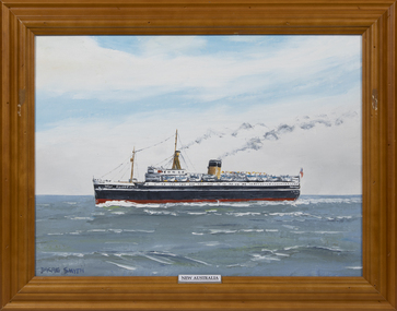 Queenscliffe Maritime Museum
Painting - New Australia, Dacre Smyth
SS New Australia was a UK-built turbo-electric passenger steamship that had a varied career from 1931 to 1966. She was built as the ocean liner Monarch of Bermuda, was a troop ship in the Second World War and was damaged by fire in 1947. She was then refitted to carry emigrants to Australia and renamed New Australia. In 1958 she was refitted again, renamed Arkadia and served as both a transatlantic liner and a cruise ship.The ship originally had three funnels. Thornycroft rebuilt her with a single funnel, plus an unusual bipod structure aft of her bridge that served as both a funnel and a mainmast. The MoT renamed her New Australia, contracted Shaw, Savill & Albion Line to manage her and put her into service carrying UK emigrants to Australia. She plied this trade from 1950 until 1957. In September 1958 New Australia was serving as a troop ship again when she suffered slight damage in a collision with a tanker in the Torres Strait.a framed oil painting of the migrant ship MV New AustraliaNew Australiamv new australia, migrant ships -
Bendigo Historical Society Inc.
Document - RESEARCH FOLDER COLLECTION: CAST IRON STRUCTURES, 1990 - 2015
Folder of research material compiled by Carol Holsworth. Received at History House in July 2023. Cast Iron Gates, Fences, Pillars, and Fountains Includes Photographs of examples of cast iron gates, fences, pillars and fountains in the Bendigo area, most with location details included. Descriptions Newspaper articles Research and history notes CataloguesCarol Holsworthbendigo, history, cast iron gates fences pillars -
Moorabbin Air Museum
Book - THE AEROPLANE STRUCTURE, A.C. KERMODE, 1964
-
Moorabbin Air Museum
Book - Luftwaffe Camouflage & Markings, 1935-45, Vol 1, K.A.Merrick
The book is a biographical coverage of the American 90th Bomb Group and its service during World War two. The book covers their active operations, inside thoughts about the group, and the commanders who commanded it. it is primarily structured as a narrative with accompanying photography.The front is a Black cover with a picture of a German twin turbine bomber. The back is a yellow cover with illustrations of the side of German aircraft.non-fictionThe book is a biographical coverage of the American 90th Bomb Group and its service during World War two. The book covers their active operations, inside thoughts about the group, and the commanders who commanded it. it is primarily structured as a narrative with accompanying photography.second world war, world war two, air bombing, united states air force, pacific theatre -
Moorabbin Air Museum
Book - Aircraft maintenance, Maintenance And Repair Of Aerospace Vehicles Third Edition Northrop Institute of Technology
Textbook for construction, inspection, operation & maintenance of structures, systems, powerplants for aircraft & other aerospace vehicles. Circa late 1960snon-fictionTextbook for construction, inspection, operation & maintenance of structures, systems, powerplants for aircraft & other aerospace vehicles. Circa late 1960s -
 Kew Historical Society Inc
Plan - Subdivision Plan, H C Crouch, Old Golf Links Estate, 1930s
The land in North Kew between the Outer Circle Railway and the River Yarra was released in sections. This release included 80 lots. Most of this area was released during the Depression years in the early 1930s.Subdivision plans are historically important documents used as evidence of the growth of suburbs in Australia. They frequently provide information about when the land was sold on which a built structure was subsequently constructed as well as evidence relating to surveyors and real estate and financial agents. The numerous subdivision plans in the Kew Historical Society's collection represent working documents, ranging from the initial sketches made in planning a subdivision to printed plans on which auctioneers or agents listed the prices for which individual lots were sold. In a number of cases, the reverse of a subdivision plan in the collection includes a photograph of a house that was also for sale by the agent. These photographs provide significant heritage information relating house design and decoration, fencing and household gardens.One part of a massive subdivision of the Old Golf Links Estate in North Kew of 80 allotments bordering Sutherland Avenue, Ramsay Avenue, Belford Road, Beresford Street and Coleman Avenue. Inset on the plan at the top left, the route of the Outer Circle Railway is clearly marked. The Kew Golf Links is identified in its current location. The land on which Greenacres Golf Club was to be constructed is at this time marked as ‘Recreation Ground’. The ‘new bridge’ over the Yarra at Burke Road is also marked on the inset map. The Plan identifies the surveyor (sic) H.C. Crouch BCE MVIS, 443 Little Collins St., Melbourne. The date of the subdivision auction sale in identified as Saturday September 25th at three o'clock.Annotations: "E" top left. "Golf Links" top right. Lots 73-76 ticked and listed as "6" poundssubdivisions -- kew (vic.), old golf links estate -
 Kew Historical Society Inc
Photograph - 29 Uvadale Grove, Kew, 1920
The numerous subdivision plans in the Kew Historical Society's collection represent working documents, ranging from the initial sketches made in planning a subdivision to printed plans on which auctioneers or agents listed the prices for which individual lots were sold. In a number of cases, the reverse of a subdivision plan in the collection includes a photograph of a house that was also for sale by the agent. Subdivision plans are historically important documents used as evidence of the growth of suburbs in Australia. They frequently provide information about when the land was sold on which a built structure was subsequently constructed as well as evidence relating to surveyors and real estate and financial agents. These photographs provide significant heritage information relating house design and decoration, fencing and household gardens.When 29 Uvadale Grove, Kew was offered for sale it was described as: ‘Kew. Fine locality, 3 minutes Cotham Road. Splendidly built 6 roomed Brick Villa. Rooms 17 x 14, 16 x 13, &c. Beautifully fitted throughout. Land 70 x 134 to ROW.’ The price was advertised as being £1,400. The house exhibits key features of Federation architecture such as the gabled roof with a facing of half-timber and stucco. The veranda has a curved corrugated iron roof supported by timber pillars and fretwork. The slate roof with terra cotta ridging and finials marks a transition to the more common use of Marseilles tiles in Federation architecture.subdivisions - kew (vic.), 29 uvadale grove - kew (vic.) -
 Kew Historical Society Inc
Photograph - 'Mount Eri', 9 Highbury Grove, 1919
Subdivision plans are historically important documents used as evidence of the growth of suburbs in Australia. They frequently provide information about when the land was sold on which a built structure was subsequently constructed as well as evidence relating to surveyors and real estate and financial agents. The numerous subdivision plans in the Kew Historical Society's collection represent working documents, ranging from the initial sketches made in planning a subdivision to printed plans on which auctioneers or agents listed the prices for which individual lots were sold. In a number of cases, the reverse of a subdivision plan in the collection includes a photograph of a house that was also for sale by the agent. These photographs provide significant heritage information relating house design and decoration, fencing and household gardens.A photograph of Mount Eri, 9 Highbury Grove, an 11-room house for sale near the junction of Cotham and Glenferrie Roads. The substantial red brick, slate-roofed house and its location are not identified in the photograph, although the extent of the house is noted. It was described then as ‘well situated’ and close to 3 trams. Mathers, a financial agent in Cotham Road, placed advertisements about the sale of the property in The Argus in May and June 1919. The advertisement additionally refers to a billiard room and asserts that the house has every modern convenience. An annotation on the plan indicates that the house, with tennis court, was sold for £1960. Following extensive research, the house has now been conclusively identified, albeit extended and rendered. The house was originally built in the 19th century as a school and for much of the 20th century was used as a venue for receptions. -
 Kew Historical Society Inc
Photograph - Victorian Villa, High Street, c.1922
Subdivision plans are historically important documents used as evidence of the growth of suburbs in Australia. They frequently provide information about when the land was sold on which a built structure was subsequently constructed as well as evidence relating to surveyors and real estate and financial agents. The numerous subdivision plans in the Kew Historical Society's collection represent working documents, ranging from the initial sketches made in planning a subdivision to printed plans on which auctioneers or agents listed the prices for which individual lots were sold. In a number of cases, the reverse of a subdivision plan in the collection includes a photograph of a house that was also for sale by the agent. These photographs provide significant heritage information relating house design and decoration, fencing and household gardens.An old inscription on this photograph identifies it as ‘an elegant timber villa in High Street. It occupied part of Lot 91, bought by Edward Glyn in the land sale of 16th October 1851, and run as a flower farm’. The subdivision called the ‘Flower Farm Estate’ in East Kew occurred in 1922. [The subdivision plan is on the reverse of this photo.] The Estate included 61 lots on either side of Boorool Road between High Street and Harp Road. In the MMBW Detail Plan 2017 of 1926, a number of these new villas had already been built. Matching houses with MMBW maps can always be a challenge, however if this house was near the corner of Boorool Road and High Street, it seems to fit the profile of a house called ‘Maxton’ (demolished).Photographer's name on photograph, lower right, and stamp on mount lower right: "A. Aberline, Glenferrie".houses - maxton - high street - kew (vic.), violet farm estate, subdivisions - kew (vic.) -
 Kew Historical Society Inc
Photograph - W.B. Villa, Kew, c.1919
The photograph offers significant information relating to late Victorian / Federation colour schemes and fencing.The block fronted villa has a corrugated iron roof and a flat projecting verandah, ornamented with a trellis design of timber. The front window features a timber shade, mounted on brackets. The treatment of the block-fronted panels shows that there is an attempt to highlight imitation quoining through use of a darker colour. The windows and door are also in this darker shade. The front fence and gate are made of wooden pickets. It is unlikely that the photograph was taken at the time of the villa's construction given the size of the shrub/tree in the front garden.Subdivision plans are historically important documents used as evidence of the growth of suburbs in Australia. They frequently provide information about when the land was sold on which a built structure was subsequently constructed as well as evidence relating to surveyors and real estate and financial agents. The numerous subdivision plans in the Kew Historical Society's collection represent working documents, ranging from the initial sketches made in planning a subdivision to printed plans on which auctioneers or agents listed the prices for which individual lots were sold. In a number of cases, the reverse of a subdivision plan in the collection includes a photograph of a house that was also for sale by the agent. These photographs provide significant heritage information relating house design and decoration, fencing and household gardens.A real estate photograph, mounted on brown card, showing a double fronted weatherboard villa, located in Kew, Victoria. On the reverse of the photograph is a subdivision plan for the Altyre Estate.Stamped on mount: Top - "KEW. Close tram. Fine View. / W.B. Villa Containing 8 Rooms. / Up-to-date Conveniences. EL Etc." Below - "Land 40 x 165. 615 pounds. Sold"houses - kew, real estate photographs -
![Kew and Hawthorn: Further heritage investigations - Assessment of specific sites / [by] Lovell Chen](/media/collectors/550653872162f11fb04854aa/items/5ebc8bf1a9d32b09e4a3fcb7/item-media/5ebc8c98a9d32b09e4a43ea2/item-fit-380x285.jpg) Kew Historical Society Inc
Kew Historical Society IncBooklet, Lovell Chen, Kew & Hawthorn: Further heritage investigations - Assessment of specific sites - Summary Report, 2011
Heritage Report of built structuresHeritage investigations. Assessment of specific sites in Kew and Hawthorn. Summary Report.non-fictionHeritage Report of built structuresheritage - kew (vic.), heritage - hawthorn (vic.) -
Kew Historical Society Inc
Journal, Kewriosity : November 1992
Kew enters bicycle friendly awards / p1. Carols by Candlelight / p1. Kew Business Co-ordinator / p1. Chief Executive's Column [New State Government Deficit Levy; Changes to Kew's Corporate Structure] / Malcolm Hutchinson pp2&3. Mayor's Comment / Cr Roger Streeton p.3. Diary Dates [November - December 1992] / p4. New Chapel for Trinity Grammar / p5. HIB Vaccination now available / p5. In Brief [Tennis anyone; 1993 Kinder enrolments; Kew Council School Holiday Program; Kew Band wins State award; Victorian Blind Cricket Association] p6. Snakes in Kew / p7. [4th] Kew Scouts looking good / p7. Rubella warning / p8. Town Crier wanted / p8. Area 6 Traffic Management Committee [area bounded by Cotham Rd, High St, Harp Rd, Burke rd] / p8.Kewriosity was a local newsletter combining Kew Council and community news. It was published between November 1983 and June 1994, replacing an earlier Kewriosity [broad] Sheet (1979-84). In producing Kewriosity, Council aimed to provide a range of interesting and informative articles covering its deliberations and decision making, together with items of general interest and importance to the Kew community and information not generally available through daily media outlets.non-fictionKew enters bicycle friendly awards / p1. Carols by Candlelight / p1. Kew Business Co-ordinator / p1. Chief Executive's Column [New State Government Deficit Levy; Changes to Kew's Corporate Structure] / Malcolm Hutchinson pp2&3. Mayor's Comment / Cr Roger Streeton p.3. Diary Dates [November - December 1992] / p4. New Chapel for Trinity Grammar / p5. HIB Vaccination now available / p5. In Brief [Tennis anyone; 1993 Kinder enrolments; Kew Council School Holiday Program; Kew Band wins State award; Victorian Blind Cricket Association] p6. Snakes in Kew / p7. [4th] Kew Scouts looking good / p7. Rubella warning / p8. Town Crier wanted / p8. Area 6 Traffic Management Committee [area bounded by Cotham Rd, High St, Harp Rd, Burke rd] / p8.publications -- city of kew (vic.), kewriosity, council newsletters, community newsletters -
Kew Historical Society Inc
Journal, Kewriosity : June 1991
Re locations [North Kew Tennis Club, 1st Kew Scouts] / 1. North's replacement kinder [Kew Preschool Association and North Kew Kindergarten in Pakington Street] / p1. Kinders - What to do? [Council finances] / p1. Junction Traffic Study / p1. Diary dates for June / p2. Bravo, Band! [Kew Youth Band, Kew Band] / p2. World's best animation [3 MBS fundraising] / p2. Travelling friends [St Anthony's Children's Home reunion] / p2. Commentary [Council budget] / Cr Daryl Oldaker p3. Chief Executive's Column [corporate structure] / Malcolm Hutchinson p3. Beat the beetle [elm leaf beetle] / p4. One electorate: six winners [Hare Clark system] / p4. Heritage Planning [Heritage Residential Zone and individual building controls] / p4. Vale - Allan Hutchinson J.P. 1938-1991 [obituary] / p4. Kewriosity lives on / p5. Nappies in Walpole Street [baby change room] / p6. St George's not dragg'n its feet [Three Year Accreditation Certificate] / p6. Get a dog ... But register it / p6. Sisters kick up heels [Our Lady of Missions dance] / p6. Davis Street's open day [Davis Street Kindergarten] / p7. Baby, Look at us now [High Street Kindergarten] / p6. [Fourth Kew] Scouts host Chernobyl children / p6. New threesome [Trio Nova] / p7. A good get-together [Kew Community House] / p7. A certain timbre [furniture design] / 7. Pride on wheels / p7. Keeping home fires burning [Dunnings Wood Yard] / p7. 1938 diarists / p8. Carey picnic / p8. Henry VIII Birthday / p8. Walk the Outer Circle [walking tours by Australian Railway Historical Society] / p8.Kewriosity was a local newsletter combining Kew Council and community news. It was published between November 1983 and June 1994, replacing an earlier Kewriosity [broad] Sheet (1979-84). In producing Kewriosity, Council aimed to provide a range of interesting and informative articles covering its deliberations and decision making, together with items of general interest and importance to the Kew community and information not generally available through daily media outlets.non-fictionRe locations [North Kew Tennis Club, 1st Kew Scouts] / 1. North's replacement kinder [Kew Preschool Association and North Kew Kindergarten in Pakington Street] / p1. Kinders - What to do? [Council finances] / p1. Junction Traffic Study / p1. Diary dates for June / p2. Bravo, Band! [Kew Youth Band, Kew Band] / p2. World's best animation [3 MBS fundraising] / p2. Travelling friends [St Anthony's Children's Home reunion] / p2. Commentary [Council budget] / Cr Daryl Oldaker p3. Chief Executive's Column [corporate structure] / Malcolm Hutchinson p3. Beat the beetle [elm leaf beetle] / p4. One electorate: six winners [Hare Clark system] / p4. Heritage Planning [Heritage Residential Zone and individual building controls] / p4. Vale - Allan Hutchinson J.P. 1938-1991 [obituary] / p4. Kewriosity lives on / p5. Nappies in Walpole Street [baby change room] / p6. St George's not dragg'n its feet [Three Year Accreditation Certificate] / p6. Get a dog ... But register it / p6. Sisters kick up heels [Our Lady of Missions dance] / p6. Davis Street's open day [Davis Street Kindergarten] / p7. Baby, Look at us now [High Street Kindergarten] / p6. [Fourth Kew] Scouts host Chernobyl children / p6. New threesome [Trio Nova] / p7. A good get-together [Kew Community House] / p7. A certain timbre [furniture design] / 7. Pride on wheels / p7. Keeping home fires burning [Dunnings Wood Yard] / p7. 1938 diarists / p8. Carey picnic / p8. Henry VIII Birthday / p8. Walk the Outer Circle [walking tours by Australian Railway Historical Society] / p8. publications -- city of kew (vic.), kewriosity, council newsletters, community newsletters -
Kew Historical Society Inc
Journal, Kewriosity : July 1985
Kew Safeway expansion / p1. Community Notes [Clubs and Societies; General; Politics; Religious notices; Support Groups] / p2&16.Update: Notes from Council - Kew's parklands / Cr Robin Saunders, Mayor [of Kew] p3. In Brief [We are desperate - Kew Community Bus; No Vacancy - Davis Street Kindergarten; Kew contributes to Housing Council; This is an emergency - Meals on Wheels; Elections coming up; Assistance grants distributed; Fence trees soon] / p4. Traffic Management / p4. Concern for residents top priority in hotels dispute [Prospect Hill Hotel; Harp of Erin/ p5. Friends of Kew Library take action {Library relocation; Kew Historical Society; Toy Library] / p5. Baby safety bassinet loan scheme off and running / p5. Neighbourhood Watch - Keeping an eye open [Operation identification / Neighbourhood Watch works; Home security meeting] / p6. Kew Community House - What we are about / p6. Kew Heritage Survey - Information exchange meeting / p7. Heritage assets [Houses and other buildings; Other structures and works; Streetscapes; Sites; Natural areas and open space; Panoramas, vistas or views] / p8. Nomination of potential heritage asset [survey form] / p9.Further comment [Line drawing - 'Ivy Grange'] / p10. Youth Page - Youth Theatre a-goer; Apology / p11. Some ways to avoid burning [incinerators] / p12. Learn how to paint on silk / p12. The ABC of the CAB [Citizens Advice Bureau] / p13. High times at Kew's Cemetery / Ellen Coates [social history] p14. Archer of the year 1984/85 [Gerry Hevey, Kew City Bowmen] / p15. Library News / p15. This Kewriosity is being delivered to you by - Kew Women's Hockey Club / p15. Letters - Small Business too pricey /Mrs J Chambers; Theft and vandalism hits Bowmen / Jim Bagnelli; A case of discrimination / Kathy Don.Kewriosity was a local newsletter combining Kew Council and community news. It was published between November 1983 and June 1994, replacing an earlier Kewriosity [broad] Sheet (1979-84). In producing Kewriosity, Council aimed to provide a range of interesting and informative articles covering its deliberations and decision making, together with items of general interest and importance to the Kew community and information not generally available through daily media outlets.non-fictionKew Safeway expansion / p1. Community Notes [Clubs and Societies; General; Politics; Religious notices; Support Groups] / p2&16.Update: Notes from Council - Kew's parklands / Cr Robin Saunders, Mayor [of Kew] p3. In Brief [We are desperate - Kew Community Bus; No Vacancy - Davis Street Kindergarten; Kew contributes to Housing Council; This is an emergency - Meals on Wheels; Elections coming up; Assistance grants distributed; Fence trees soon] / p4. Traffic Management / p4. Concern for residents top priority in hotels dispute [Prospect Hill Hotel; Harp of Erin/ p5. Friends of Kew Library take action {Library relocation; Kew Historical Society; Toy Library] / p5. Baby safety bassinet loan scheme off and running / p5. Neighbourhood Watch - Keeping an eye open [Operation identification / Neighbourhood Watch works; Home security meeting] / p6. Kew Community House - What we are about / p6. Kew Heritage Survey - Information exchange meeting / p7. Heritage assets [Houses and other buildings; Other structures and works; Streetscapes; Sites; Natural areas and open space; Panoramas, vistas or views] / p8. Nomination of potential heritage asset [survey form] / p9.Further comment [Line drawing - 'Ivy Grange'] / p10. Youth Page - Youth Theatre a-goer; Apology / p11. Some ways to avoid burning [incinerators] / p12. Learn how to paint on silk / p12. The ABC of the CAB [Citizens Advice Bureau] / p13. High times at Kew's Cemetery / Ellen Coates [social history] p14. Archer of the year 1984/85 [Gerry Hevey, Kew City Bowmen] / p15. Library News / p15. This Kewriosity is being delivered to you by - Kew Women's Hockey Club / p15. Letters - Small Business too pricey /Mrs J Chambers; Theft and vandalism hits Bowmen / Jim Bagnelli; A case of discrimination / Kathy Don. publications -- city of kew (vic.), kewriosity, council newsletters, community newsletters -
 Kew Historical Society Inc
Plan, Studley Heights Estate, 1936
Pru Sanderson, in her groundbreaking ‘City of Kew Urban Conservation Study : Volume 2 - Development History’ (1988), summarised the periods of urban development and subdivisions of land in Kew. The periods that she identified included 1845-1880, 1880-1893, 1893-1921, 1921-1933, 1933-1943, and Post-War Development. These periods were selected as they represented periods of rapid growth or decline in urban development. An obvious starting point for Sanderson’s groupings involved population growth and the associated economic cycles. These cycles also highlighted urban expansion onto land that was predominantly rural, although in other cases it represented the decline and breakup of large estates. A number of the plans in the Kew Historical Society’s collection can also be found in other collections, such as those of the State Library of Victoria and the Boroondara Library Service. A number are however unique to the collection.Subdivision plans are historically important documents used as evidence of the growth of suburbs in Australia. They frequently provide information about when the land was sold on which a built structure was subsequently constructed as well as evidence relating to surveyors and real estate and financial agents. The numerous subdivision plans in the Kew Historical Society's collection represent working documents, ranging from the initial sketches made in planning a subdivision to printed plans on which auctioneers or agents listed the prices for which individual lots were sold. In a number of cases, the reverse of a subdivision plan in the collection includes a photograph of a house that was also for sale by the agent. These photographs provide significant heritage information relating house design and decoration, fencing and household gardens.The ‘Studley Heights Estate’ on the South Side of Studley Park Road was launched in 1936. The seventeen allotments in the subdivision fronted Hyton Crescent and Studley Park Road.subdivision plans - kew, studley heights estate