Showing 2010 items
matching bendigo show
-
 Bendigo Historical Society Inc.
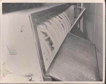
Photograph - BENDIGO BUTTER FACTORY PHOTOGRAPH 1957?
Black & white photograph 20cm x 25cm of the Bendigo Butter Factory in Mundy St., mounted on cardboard. It appears to have been part of a display, with explanatory notes attached to each photograph. See 3713-7d. On the reverse of the title photograph is the date 1950-1955 and a blue registration stamp with the words 'Pure creamery, Australia, Victoria regd'. An interior photograph shows a calendar with the date March 1957. This photograph is one of the cream being processed into butter.bendigo, industry, bendigo butter factory, bendigo butter factory. -
 Bendigo Historical Society Inc.
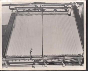
Photograph - BENDIGO BUTTER FACTORY PHOTOGRAPH 1957?
Black & white photograph 20cm x 25cm of the Bendigo Butter Factory in Mundy St., mounted on cardboard. It appears to have been part of a display, with explanatory notes attached to each photograph. See 3713-7d. On the reverse of the title photograph is the date 1950-1955 and a blue registration stamp with the words 'Pure creamery, Australia, Victoria regd'. An interior photograph shows a calendar with the date March 1957. This photograph is of cream being processed into butter.bendigo, industry, bendigo butter factory, bendigo butter factory. -
 Bendigo Historical Society Inc.
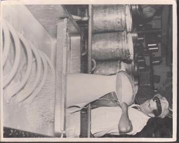
Photograph - BENDIGO BUTTER FACTORY PHOTOGRAPH 1957?
Black & white photograph 20cm x 25cm of the Bendigo Butter Factory in Mundy St., mounted on cardboard. It appears to have been part of a display, with explanatory notes attached to each photograph. See 3713-7d. On the reverse of the title photograph is the date 1950-1955 and a blue registration stamp with the words 'Pure creamery, Australia, Victoria regd'. An interior photograph shows a calendar with the date March 1957. This photograph shows a worker pouring cream into a strainer and cooler? He is named on the reverse as W. Brice.bendigo, industry, bendigo butter factory, bendigo butter factory. brice, w. -
 Bendigo Historical Society Inc.
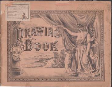
Book - DRAWING BOOK: PHOEBE LANSELL, 1880
'Drawing Book' - attached plate stating 'Student's Name' : Phoebe Lansell.; 'School Number': 161 Other ??. Pinky - fawn coloured cover - string- bound with cardboard pages and separating tissue paper .The front cover has a landscape scene sketch .An angel and cherub are holding back a curtain .A label shows School number 161 .The back cover shows a sketch of 'New Princes Bridge .Melbourne ' and St Patricks Cathedral-Post 1880's 90's .Inside are pencil sketchesperson, individual, phoebe lansell -
 Bendigo Historical Society Inc.
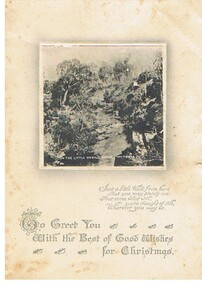
Document - MALONE COLLECTION: GREETING CARDS
Cream card with a 7 x 7 cm black & white scene of The Little Devil River, Victoria. The scene shows the river, trees & rocks. There is a narrow white border around the picture with grey shading. A verse is printed underneath.person, greeting cards, malone collection, malone collection, greeting cards -
 Bendigo Historical Society Inc.
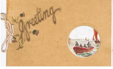
Document - MALONE COLLECTION: GREETING CARDS
Beige vellum card with white insert. Insert has 3.8mm coloured circular scene of 4 men in a red row boat with sailing boats in the background. The vallum outer has a cutout to show the scene. On the right is 'Greeting' printed in Brown & gold. Some thistle flowers around the G. Card and insert held together with a mauve cord.British Manufactureperson, greeting cards, malone collection, malone collection, greeting cards -
 Bendigo Historical Society Inc.
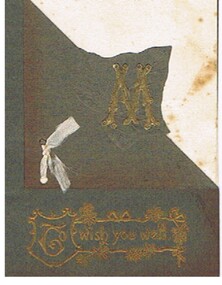
Document - MALONE COLLECTION: GREETING CARDS
Document. Greeting Cards. Grey card with a leaf embossed on it and cut along the leaf, folded back and tied with a piece of cream ribbon. Over the leaf is a gold embossed M. Below Printed in gold with decoration is: 'To wish you well'. Card has a cream insert which shows at the front where the grey has been folded back. Inside is printed 'From Mr. & Mrs. D. Malone Ninda Sea Lakeperson, greeting cards, malone collection, malone collection, greeting cards, mr. & mrs. d. malone, ninda sea lake -
 Bendigo Historical Society Inc.
Accessory - F. G. JONES COLLECTION: MASONIC DECORATIONS X 2, 1940's
Object. 1 - Life Governors Medal on sky blue ribbon for Freemasons Homes of Victoria. Small gold front plan of a building mounted centrally to ribbon. Medallion shows a 5 pointed star over a laurel wreath. Gold coloured compass & square on blue enamel background mounted in centre, long pin on the back. 2 - Keystone medal, burgundy & grey ribbon with mallet & chisel motif in metal, small white stone with lettering 'KSHT WSST' and Hebrew characters on reverse.societies, freemasons, regalia, f.g. jones collection, masonic decorations x 2 -
Bendigo Historical Society Inc.
Document - CENTRAL GOLDFIELDS RESTORATION FUND, March 1986
Pamphlet on the Central Goldfields Restoration Fund issued by the Victorian Ministry for Planning and Environment. Includes a map of the central goldfields region, introduction by Jim Kennan (Minister) and 3 photographs. Also a description on how the fund operates and how to apply for assistance. An insert of 2 blank application forms. Photos show , Miners using a sluice at Tarnagulla c.1880. Cnr of Sturt and Lydiard Sts, Ballarat c.1880. E. Eberhard Cordial Factory at Clunes c.1890.Victorian Ministry for Planning and Environmentorganization, government, central goldfields, restoration fund, ministry for planning and environment, j. kennan, tarnagulla, ballarat, clunes. -
 Bendigo Historical Society Inc.
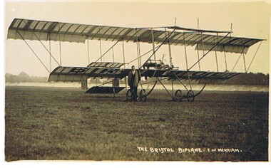
Postcard - BASIL WATSON COLLECTION: BRISTOL BIPLANE F.W. MERRIAM
Postcard: sepia coloured card, biplane. Written on bottom of card: 'The Bristol Biplane, F.W. Merriam' Image shows a biplane and man standing in front of plane.aviation, civilian, bristol biplane, basil watson, biplane -
 Bendigo Historical Society Inc.
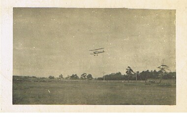
Postcard - BASIL WATSON COLLECTION: BIPLANE FLYING OVER COUNTRYSIDE
Postcard: biplane flying over countryside. Image shows plane, countryside not known.aviation, civilian, biplane, basil watson, biplane -
 Bendigo Historical Society Inc.
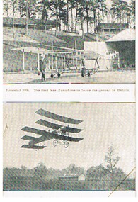
Postcard - BASIL WATSON COLLECTION: AVRO PLANE
Postcard: black and white card - two sections. On top aeroplane, 'Patented 1906, the first free aeroplane to leave the ground in Britain' On bottom of card, photo of three tiered wing aeroplane. Written on bottom' Avro' plane flying with only 14 h.p. On back of card: The 'Avro'plane. The first aeroplane illustrated was the first free heavier-than-air machine to leave the the ground. Before this however, very interesting flights were made when towed by a motor car at Brooklands Track. The other photo shows a flight with 14 horse power, but previous to this some hundreds of flights were made with only a nine horse power engine. A record which has not yet been beaten or equalled. Mr. A.V. Roe is now making monoplanes, biplanes and triplanes &c. For full particulars please write to A.V. Roe & Co., Brownsfield Mills, Manchester.aviation, civilian, avro biplane, basil watson, biplane, aeroplane -
 Bendigo Historical Society Inc.
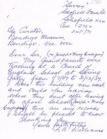
Document - CORRESPONDENCE RE: JOSEPH & MARY CADOGEN
School Correspondence to BHS re Joseph & Mary Cadogen and school at Spring Gully - information supplied to writer (Mr Willliams, Schofield NSW) 1971 re the school.. Location: First record available dates from the beginning of 1856. It is the Denominational School Board record from the Rev. J. D. Brennan of the Church of England. The record reads: School was conducted by Joseph Cadogen in the church hall which was used as a Sunday School of the wesleyan Chapel about the beginning of 1856. Records of the 1857 show that the weatherboard building - with a canvas roof and wooden floor , cost £100(pounds). Head teacher was Mr. J. Cadogen who was assisted by Elizabeth Hunt, (January-March), Jane Greenehame (april-May, and Mary Cadogen. This extract from 'the Valley of the springs' was compiled by Jack Hattam who advised me of no other mention or information re J. Cadogen.cottage, miners -
 Bendigo Historical Society Inc.
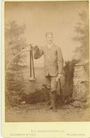
Photograph - HARRIS COLLECTION: MALE PHOTO, Ninteenth Century
Black & white E C Waddington & Co studio portrait of male standing beside penny farthing bicycle. Melbourne Show xxv xxv ? Barely discernible on gate photo right hand side. Male early thirties clothed in jackboots, breeches, buttoned up jacket, turned down collar with pale bow tie, moustache and badged cap. Double 'Albert' chain & fob watch.E C Waddington & Co Elizabetth St Melbourne.photograph, person, male -
 Bendigo Historical Society Inc.
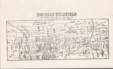
Map - BENDIGO GOLDFIELD MAP
Two not very clear copies of the Bendigo Goldfield Map. Streets, Railway Line, Lines of Reefs and mines are shown. Dept. of Mines, Victoria printed on the map. Shows reefs from Bird's Line of Reefs to Lightning Hill Line of Reef.map, bendigo, goldfields, bendigo goldfield map, lines of reefs, dept. of mines victoria -
Bendigo Historical Society Inc.
Map - UNDERGROUND SECTION OF 3 MINES
Underground section of three mines - Shaft No 94, New Chum United Co, Cross Section No 89 - Shaft No 93, Lansell's 222 (DENIS), Cross Section No 87 - Shaft No 92A (New Shaft), Lansell's 222, Cross Section No 86. Map shows depth of cross sections below the sill and stone encountered. Poppet legs are drawn at the top of the shafts. Lansell's 222 Shaft No 92A has measurements pencilled in.mining, parish map, new chum united, lansell's 222 (denis), lansell's 222 -
Bendigo Historical Society Inc.
Map - HUSTLER'S & CHRISTMAS LINES OF REEFS - PLAN OF LINES OF SECTION OF REEFS
Underground Survey of Mines Bendigo. Plan of Cross Section Lines Shewing Connections with Trigonometrical Stations and Base Lines. 13/3/99 Signed ? Stirling. Places and mines mentioned Speciman Hill, Tambour Major, Lansell's 180, Victory and Pandora, Great Extended Hustler's, Windmill Hill on Victoria Reef. Next part of map is a Plan of Lines of Section between the Hustler's and Christmas Lines of Reefs. 8/3/99. Signed ?. Transverse Section. Shows Tambour Major Co., near the Christmas Line of Reef, Crosscuts and their depth, geological features and stone encountered. Then shows Thistle Line, Charshalton Line, Napoleon Line, Nell Gwynne Line, New Chum Line, Lansell's No 180 with levels, depths and geological features. Drawing is continued in three parts to fit on paper. Lansell's East Shaft with levels and depths, geological features and stone encountered. Sheepshead Line, Old Shaft, Garden Gully Line, Victory and Pabndora Co with crosscuts, depths, geological features and stone encountered. Paddy's Gully Line, Derby Line, Millers Line, Hustler's Line, Great Extended Hustler's Co with levels, depths, geological features and stone encountered. A note beside a Saddle Reef: 360,000 pounds paid in dividends from this reef. Average ounces per ton gold noted where found. Reference Table for stone and geological features. Datum Line 700 feet above Sea Level Unscannedmining, parish map, hustler's & christmas lines of reefs, plan of lines of section of reefs, ? stirling, specimen hill, tambour major, lansell's 180, victory & pandora, great extended hustler's, windmill hill, victoria reef, tambour major co, christmas line, hustler's line, thistle line, carshalton line, napoleon line, nell gwynne line, new chum line, lansell's no 180, lansell's east shaft, sheepshead line, old shaft, garden gully line, paddy's gully line, derby line, miller's line, hustler's line, great extended hustler's co -
Bendigo Historical Society Inc.
Map - GREAT EXTENDED HUSTLER'S MINE - LONGITUDINAL SECTION OF THE GREAT EXTENDED HUSTLER'S MINE
Longitudinal Section of the Great Extended Hustler's Mine on the Hustler's Line of Reefs. Bulletin No 33, Plate No XIII. Map shows the Hustler's Tribute, 2 Old Shafts, Great Extended Hustler's Shaft, Latham & Watson's Shaft and Ironbark Gully. Datum Line 750 feet above Sea Level. Poppet Legs on the surface and Sill of Shaft 788.99 feet above Sea Level. Levels and their depths are shown and some geographical features. Some amounts of gold mined mentioned. Geological Survey of Victoria emblem and signed by H A Whitelaw, Underground Survey Office Bendigo, September 1913. Note - Plates 4, 8, 13,20, 26 & 31 form a Longitudinal Section from Fortuna Hustlers to Hustler's Consols Mine. This item has not been scanned or photographed.mining, parish map, great extended hustler's mine, longitudinal section of the great extended hustler's mine, geological survey of victoria, underground survey office bendigo, h a whitelaw, hustler's tribute, old shaft, great extended hustler's shaft, latham & watson's shaft, ironbark gully -
Bendigo Historical Society Inc.
Map - GREAT EXTENDED HUSTLER'S MINE - TRANSVERSE SECTION OF THE GREAT EXTENDED HUSTLER'S MINE
Transverse Section of the Great Extended Hustler's Mine on the Hustler's Line of Reef. Bulletin No 33, Plate No XII. Shows Poppet legs at the surface and Sill of Shaft at 788.99 feet above Sea Level, Cross Cuts and their depths, stone and geographical features encountered and their references and a number of enlarged drawing of sections of the cross cuts, Geological Survey of Victoria emblem and signed by H A Whitelaw, Underground Survey Office Bendigo, September 1913. The depths of crosscuts to No 21 were taken from plans of surveys by Mr Walker and Mr Craven, noted under Reference. Another note: This Saddle Reef is sketched from Mr Walker's plan. Dividends amounting to 360,000 pounds were obtained from it. This item has not been scanned or photographed.mining, parish map, great extended hustler's mine, transverse section of the great extended hustler's mine, old shaft, mr walker, mr craven, geological survey of victoria, underground survey office bendigo, h a whitelaw -
 Bendigo Historical Society Inc.
Map - GREAT EXTENDED HUSTLER'S MINE - PLAN OF THE GREAT EXTENDED HUSTLER'S MINE
Plan of the Great Extended Hustler's Mine. Bulletin No 33, Plate No XI. Shows No 2 Shaft, Latham & Watson's Shaft, levels and their depths and some geographical features. Geographical Survey of Victoria emblem and signed by H A Whitelaw, Underground Survey Office, Bendigo, September 1913. Has reference to photos.mining, parish map, great extended hustler's mine, no 2 shaft, latham & watson's shaft, geological survey of victoria, underground survey office bendigo, h a whitelaw -
 Bendigo Historical Society Inc.
Map - GREAT EXTENDED HUSTLER'S MINE - PLAN OF THE GREAT EXTENDED HUSTLER'S MINE
Plan of the Great Extended Hustler's Mine on the Hustler's Line of Reefs, Bendigo. Bulletin No 33, Plate No X. Lease No 7382. Plan has map of streets. Mine was located in the block bounded by Langston and Anderson Streets and was between the Hustler's Anticline at Surface and the Lightning Hill Anticline at Surface. Latham & Watson's Shaft is also mentioned. Levels are numbered and a table shows the Levels and their Depths. Geological Survey of Victoria. Signed by H A Whitelaw, Underground Suyrvey Office, Bendigo, September 1913. This item has not been scanned or photographed.mining, parish map, great extended hustler's mine, hustler's line of reefs, mining lease no 7382, geological survey of victoria, underground survey office bendigo, h a whitelaw, latham & watson's shaft -
Bendigo Historical Society Inc.
Map - FORTUNA HUSTLER'S MINE - TRANSVERSE SECTION OF THE FORTUNA HUSTLER'S MINE
Transverse Section of the Fortuna Hustler's Mine on the Hustler's Line of Reef, Bendigo. Bulletin No 33, Plate No III. Drawing shows poppet legs on the surface and Sill of Shaft 745.38 feet above Sea Level. Shows levels and their depths, geographical features and stone encountered. Reference table to stone and geographical features. Geographical Survey of Victoria emblem. Signed by H A Whitelaw, Underground Survey Office, Bendigo. This item has not been scanned or photographed.mining, parish map, fortuna hustler's mine, hustler's line of reef, geological survey of victoria, underground survey office bendigo, h a whitelaw -
 Bendigo Historical Society Inc.
Map - FORTUNA HUSTLER'S MINE - LONGITUDINAL SECTION OF THE FORTUNA HUSTLER'S MINE
Longitudinal Section of the Fortuna Hustler's Mine on the Hustler's Line of Reef, Bendigo. Bulletin No 33, Plate No IV. Shows poppet legs at the surface level, Datum Line 750 feet above Sea Level, levels and their depths, the amount of gold per ton and some geographical features. Geological Survey of Victoria emblem and signed by H A Whitelaw, Underground Survey Office, Bendigo. Note - Plates 4, 8, 13, 20, 26 & 31 form a Longitudinal Section from Fortuna Hustler's to Hustler's Consols Mine. This item has not been scanned or photographed.mining, parish map, fortuna hustler's mine, longitudinal section of the fortuna hustler's mine, geological survey of victoria, h a whitelaw, underground survey office bendigo, hustler's line of reef, hustler's consols mine -
Bendigo Historical Society Inc.
Map - HUSTLER'S CONSOLS MINE - TRANSVERSE SECTION OF THE HUSTLER'S CONSOLS MINE
Transverse Section of the Hustler's Consols Mine Bulletin No 33, Plate No XXXIII. Map shows poppet legs at the surface and Sill of Shaft 779.42 feet above Sea Level. Shows the different levels and their depths and the different stone and geographical features encountered. Has larger drawing of Section A - B. Geographical Survey of Victoria. Signed by H A Whitelaw, Underground Survey Office Bendigo, September 1913. This Item has not been scanned or Photographed.mining, parish map, hustler's consols mine, transverse section of the hustler's consols mine, geological survey of victoria, underground survey office bendigo, h a whitelaw -
Bendigo Historical Society Inc.
Map - HUSTLER'S REEF MINE - TRANSVERSE SECTION OF THE HUSTLER'S REEF MINE
Transverse Section of the Hustler's Reef Mine on the Hustler's Line of Reefs. Bulletin No 33, Plate No XVIII. Shows cross-cuts and their depth, different types of stone and geological features encountered. Drawing of poppet legs at the surface and Sill of Shaft 756.39 ft above Sea Level. Reference Table shows key to the different stone and geographical features encountered. Geographical Survey of Victoria. Signed by H A Whitelaw, Underground Survey Office, Bendigo, September 1913. Thompson's Reef is also mentioned on the map. This item has not been scanned or photographed.mining, parish map, hustler's reef mine, transverse section of the hustler's reef mine, geological survey of victoria, h a whitelaw, underground survey office bendigo, thompson's reef. -
 Bendigo Historical Society Inc.
Map - HUSTLER'S REEF MINE - EAST & WEST CROSS-CUTS, NORTH & SOUTH OF SHAFT
East & West Cross-cuts, North & South of Shaft, Hustler's Reef Mine Bulletin No 33, Plate No XIX. Map shows main shaft and smaller drawing of section with different stone encountered. Also gives location in relation to the shaft, e. g. 225'E & 150'S of Shaft. Reference diagram to show the different stone and features encountered. Geological Survey of Victoria emblem. Signed by H A Whitelaw, Underground Survey Office Bendigo, September 1913. This item has not been scanned or photographed.mining, parish map, hustler's reef mine, east & west cross-cuts north & south of shaft, geological survey of victoria, h a whitelaw, underground survey office bendigo -
Bendigo Historical Society Inc.
Map - HUSTLER'S REEF & HUSTLER'S REEF NO 1 MINES - PLAN OF THE HUSTLER'S REEF & HUSTLER'S REEF NO 1 MINES
Plan of the Hustler's Reef & Hustler's Reef No 1 Mines on the Hustler's Line of Reefs Bulletin No 33, Plate No XVII. Two drawings with different levels on each for clarity. Shows depth and some geographical features.Geological Survey of Victoria emblem. Signed by H A Whitelaw Underground Survey Office Bendigo, September 1913. This item has not been scanned or photographed.mining, parish map, hustler's reef & hustler's reef no 1 mines, plan of the hustler's reef & hustler's reef no 1 mines, hustler's line of reefs, geological survey of victoria, underground survey office bendigo, h a whitelaw -
Bendigo Historical Society Inc.
Map - HUSTLER'S REEF & HUSTLER'S REEF NO 1 MINES - PLAN OF THE HUSTLER'S REEF & HUSTLER'S REEF NO 1 MINES
Plan of the Hustler's Reef & Hustler's Reef No 1 Mines on the Hustler's Line of Reefs, Bendigo Bulletin No 33, Plate No XIV. No 8 connecting No 10 (Hustler's Reef), No 11 connecting No 13 (Hustler's Reef), No 13 (Hustler's Reef No 1) connecting No 15 (Hustler's Reef) and No 10 Hustler's Reef No 1 rise to Comet Mine. Map shows different levels in relation to the two shafts, the lines of the Hustler's Line of Reefs and the Lightning Hill Line of Reefs, the approximate Boundary of Lease and the Comet Co., the adjoining lease. Table on the left shows the levels and their depths of the two mines. Signed by H A Whitelaw, Underground Survey Office, Bendigo, September 1913. Geological Survey of Victoria emblem. This item has not been scanned or photographed.mining, parish map, hustler's reef & hustler's reef no 1 mines, plan of the hustler's reef & hustler's reef no 1 mines, hustler's line of reefs lightning hill line of reefs, comet co., h a whitelaw, underground survey office bendigo, geological survey of victoria -
Bendigo Historical Society Inc.
Map - HUSTLER'S REEF & HUSTLER'S REEF NO 1 MINES - PLAN OF THE HUSTLER'S REEF & HUSTLER'S REEF NO 1 MINES
Plan of the Hustler's Reef & Hustler's Reef No 1 Mines on the Hustler's Line of Reefs, Bendigo Bulletin No 33, Plate No XVI. Plan shows the two shafts and the levels in relation to it. No 9 Level 896 feet 9 inches connecting No 10 Level at 867 feet 2 inches. Plan shows depth of levels and geographical features. Signed by H A Whitelaw, Underground Survey Office, Bendigo. Geographical Survey of Victoria emblem.mining, parish map, hustler's reef & hustler's reef no 1 mines, hustler's line of reefs, plan of the hustler's reef & hustler's reef no 1 mines, h a whitelaw, underground survey office bendigo, geographical survey of victoria, mining -
Bendigo Historical Society Inc.
Map - HUSTLER'S REEF & HUSTLER'S REEF NO 1 MINES - PLAN OF THE HUSTLER'S REEF & HUSTLER'S REEF NO 1 MINES
Plan of the Hustler's Reef & Hustler's Reef No 1 Mines on the Hustler's Line of Reefs Bulletin No 33, Plate No XV. Plan shows the two mines with depth of levels, geological features and levels in relation to the shaft. Geological Survey of Victoria emblem and signed by H A Whitelaw, Underground Survey Office Bendigo, September 1913. Note - The Lease Boundaries shown on this plan are only in their approximate relative positions to Nos 13, Intermediate and 14 Levels of the Hustler's Reef No 1 workings, and Nos 15, 16 and 17 Levels of the Hustler's Reef workings.mining, parish map, hustler's reef & hustler's reef no 1 mines, plan of the hustler's reef & hustler's reef no 1 mines, geological survey of victoria, underground survey office bendigo, h a whitelaw, hustler's line of reefs