Showing 10473 items
matching plan
-
 Ringwood and District Historical Society
Newspaper, Scrapbook Clipping, Library Collection, Ringwood, Victoria, `
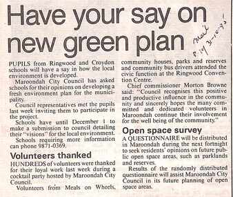
``Newspaper clipping from The "Mail" , 31-10-95 P19 .Have your say on new green plan.Pupils from Ringwood and Croydon schools will have a say in how the local environment is developed.Maroondah City Council has asked schools for their opinions on developing a fresh environment plan for the municipality. -- Hundreds of volunteers were thanked for their loyal work last week during a cocktail party hosted by Martoondah City Council. Chief Commissioner Morton Browne thanked the "many committed and dedicated volunteers". A questionnaire will be distributed in Maroondah during the next fortnight to seek residents' opinions on future public open space areas, such as parklands and reserves.` -
 8th/13th Victorian Mounted Rifles Regimental Collection
Document - letter re centenary
This was an ambitious plan. It is not clear if the event took place.Letter from Brigadier KV Rossi, Chief Marshall Anzac Day Ceremonies dated 15 January 1985 seeking agreement to a plan to have 8/13 Victorian Mounted Rifles take a key role in Anzac Day march 1985 marking 150th Anniversary of Victoria and Centenary of Victorian Mounted Rifles - Two pages.military, rsl, anzac day, centenary, melbourne -
Whitehorse Historical Society Inc.
Article, Nunawading gets parlour red light
Nunawading Council's Amenity and Community Services Committee has rejected an application for a second brothel within the city. the applicant was Janice Sharp.Nunawading Council's Amenity and Community Services Committee has rejected an application for a second brothel within the city. the applicant was Janice Sharp. If the full council meeting follows the advice of the committee and rejects the application there will almost certainly be another appeal to the Planning Appeals Tribunal.Nunawading Council's Amenity and Community Services Committee has rejected an application for a second brothel within the city. the applicant was Janice Sharp. brothels, city of nunawading. amenity and community services committee, alfred street, blackburn, coyne, william, baglin, tim, plummer, jan, thornton crescent, mitcham, sharp, janice, victoria. planning appeals tribunal -
Whitehorse Historical Society Inc.
Map, Site for Wesleyan Church, Nunawading, 1855
Photocopy of manuscript map showing names of landholders.Photocopy of manuscript map showing names of landholders. Note on verso: Plan of allotments in the City of Melbourne appropriated to the Wesleyans. Site for Wesleyan Church, Nunawading 1848 (Corner of Burwood and Elgar Roads - S of Burwood, W of Elgar)Photocopy of manuscript map showing names of landholders. churches, wesleyan church, burwood, burwood road, burwood, elgar road, burwood, maps -
 Surrey Hills Historical Society Collection
Book, Keep it for the future - how to set up small community archives, 2007
Contents/Summary: Getting started - collecting records and keeping archives: what are archives?; common mission of archives; types of records; deciding whether to set up an archives or donate records; developing an archives policy -- Acquiring and organising archives: deciding what to keep - appraisal; Receiving records - acquisition; Recording essential information - accessioning; Arranging and describing records -- Preserving archives: storing archives; packaging and containers; Environmental conditions; handling archives -- Accessing archives: access policy; access forms; archives reading room; register of requests for records; security measures; copyright and privacy; guides and fact sheets; copying; volunteers; promotion and display; grants for community heritage collections -- Preparing a disaster recovery plan -- Appendices: Sources for further information; Archiving software; Suppliers of archival papers and products. Soft cover book of 64 pages, indexed; broad areas covered are acquisition, management, preservation, access and disaster plan recovery for community archives.Soft cover book of 64 pages, indexed; broad areas covered are acquisition, management, preservation, access and disaster plan recovery for community archives.archives -
 Surrey Hills Historical Society Collection
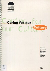
Book, Caring for our culture: national guidelines for museums, galleries and keeping places, 1998
This book contains a series of questions framed to help museums explore their direction and plans for the future and a set of 'technical guidelines' which set out minimum standards and which are for self evaluation by the museum.39p; 30 cm; This book contains a series of questions framed to help museums explore their direction and plans for the future and a set of 'technical guidelines' which set out minimum standards and which are for self evaluation by the museum.museums, administration, keeping places, galleries, guidelines -
 Federation University Historical Collection
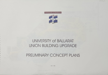
Plan, University of Ballarat Union Building Upgrade Preliminary Concept Plans, November 1998, 11/1998
University of Ballarat is a predecessor of Federation UniversitySpiral bound Plans for University of Ballarat Union Building Upgrade Nov 1998union building upgrade, university of ballarat, preliminary concept plans, union building, albert coates building, mount helen campus, building, u building -
Glenelg Shire Council Cultural Collection
Plan - Plan - Portland, Victoria, n.d
Plan of Portland, compiled and drawn by T.E.C. Henry, Assistant Surveyor, Nov. 1893 -
 Federation University Historical Collection
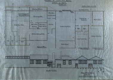
Plan - Plans, Ballarat School of Mines Plans for the Additions to Trades Class Rooms
Born in Ballarat, George William Clegg F.R.V.I.A. was articled to Tappin, Gilbert and Dennehy who had architectural offices in Melbourne, Sydney and Ballarat, from 1885-1889. Clegg formed a partnership with Gilbert who ran the Ballarat Office and later with Kell and Miller. This eventually became Clegg and Miller, then Clegg Miller and Morrow, and finally Clegg and Morrow (1916). From about 1907 up until his resignation in 1918 Clegg taught Architecture and Building Construction at the Ballarat School of Mines. From 1918 he pursues interests in the Eureka Terracotta and Tile Company.Two plans on linen, relating to additions in the trade classrooms at the Ballarat School of Mines.ballarat school of mines, george clegg, george william clegg, george w. clegg, clegg, miller and morrow, trades, architecture, buildings -
Federation University Historical Collection
Plan - Plans, Barkly Street Girls' School Sewerage Plans, c1952
Two hand coloured sewerage plans .1) Barkly Street .2) as aboveplans, sewerage plans, percy everett, barkly street, ballarat east, girls' school -
Port Melbourne Historical & Preservation Society
Plan - Operation geometry of gantry, Inner East, Ferry Terminal, Station Pier, Port Melbourne, Engineering Division, Port of Melbourne Authority, 27 May 1985
Plan - Operation geometry of gantry at Station Pier Inner East Ferry Terminalmelbourne harbor trust - port of melbourne authority -
Port Melbourne Historical & Preservation Society
Plan - Passenger ship, Oriana, shipside doors and centres of cranes, Vckers-Armstrong Ship Building Ltd, 1961
Plan - Passenger ship Oriana (1961) - shipside doors and centres of cranes - arrangement.melbourne harbor trust - port of melbourne authority -
Port Melbourne Historical & Preservation Society
Plan, The Township of Sandridge, 30 Mar 1859
Plan of the township of Sandridge.Lithographed at the Public Lands Office, Melbourne, March 30th 1859engineering - roads streets lanes and footpaths, municipal district of sandridge -
Port Melbourne Historical & Preservation Society
Plan - Fencing, Ada Mary A'Beckett Free Kindergarten, Fishermans Bend, Martin & Tribe, Architects, 25 May 1948
Martin & Tribe - ArchitectsBlueprint of plan: Fencing layout Ada Mary A'Beckett Free Kindergarten, 1947education - kindergartens, garden city, built environment - civic, fishermans bend, ada mary a'beckett, martin & tribe, ada mary a'beckett kindergarten -
Port Melbourne Historical & Preservation Society
Plan - Side balcony, Port Melbourne Town Hall, Port Melbourne City Council, 1916
Plan - Details of side balcony, doors and main windows (1915 Town Hall).port melbourne town hall -
Port Melbourne Historical & Preservation Society
Plan - Open drainage channel, cnr Beach Street and Railway Place, Port Melbourne, Frederick William Bull, Principal Surveyor, 1862
Plan for open drainage channel at corner of Beach Street and Railway Place, 1892."Open Channel at Foot of Railway Place":Signed by Frederick William Bull, Principal Surveyorengineering - canals and drainage, engineering department - borough of sandridge, frederick william bull, business and traders - hotels -
Port Melbourne Historical & Preservation Society
Plan - Central rockery, Graham Street between Station and Princes Street, Port Melbourne, Engineering Department, City of Port Melbourne, 1950s
Plan - Central rockery in Graham Street between Station and Princes Street, 1950s.built environment - civic, parks and gardens -
Port Melbourne Historical & Preservation Society
Plan - Soundings, Yarra River, Operation Division, Port of Melbourne Authority, Jul 1987
Port of Melbourne Authority. Plan: soundings of Yarra River at entrance Beacon No 23melbourne harbor trust - port of melbourne authority, beacon no 23 -
Port Melbourne Historical & Preservation Society
Plan - Elevations at Concourse Level for gangway at Outer West berth, Station Pier, Port Melbourne, Port of Melbourne Authority, 1987
Plan - Elevations at Concourse Level - Gangway Station Pier - Outer West Berthpiers and wharves - station pier, melbourne harbor trust - port of melbourne authority -
Port Melbourne Historical & Preservation Society
Plan - Details at Concourse Level for gangway at Outer West berth, Station Pier, Port Melbourne, Port of Melbourne Authority, 1987
Plan - Details at Concourse Level - Gangway - Station Pier - Outer West Berthpiers and wharves - station pier, melbourne harbor trust - port of melbourne authority -
Port Melbourne Historical & Preservation Society
Plan - Williamstown Road from Farrell Street to Derham Street, Engineering Department, Town of Port Melbourne, 1893 - 1919
Plan of Williamstown Road, from Farrell Street to Derham Street. Loan No.5.engineering - roads streets lanes and footpaths -
Port Melbourne Historical & Preservation Society
Plan - Various ships, Melbourne Harbor Trust, 1980s
Various shipping plans of passenger ships from Melbourne Harbor Trust 1980s.piers and wharves - station pier, melbourne harbor trust - port of melbourne authority -
Port Melbourne Historical & Preservation Society
Plan - Concept, Boulevard upgrade at Sandridge Beach, landscape, 2003
Plans. Landscape concept for the Boulevard upgrade at Sandridge Beach. Dated October 2003local government - city of port phillip, engineering - roads streets lanes and footpaths -
Port Melbourne Historical & Preservation Society
Plan - Improvments, Beach Street, Port Melbourne, Beach Street Improvements, 9 Nov 1915
Plan for Beach Street improvements 1915 - hand drawn in ink and hand coloured.Signed by Heath and Chairman RH Gill - Scale altered in red ink from 2ft to the inch to 4ft to the inch (at bottom centre)built environment - civic, arthur victor heath, town clerks, richard henry gill, mayors -
Port Melbourne Historical & Preservation Society
Plan - Football Ground, Department of Survey & Lands, 13 May 1880
Plan for Football Ground on land being granted by Department of Survey & Lands, 1880sport - australian rules football, sport - recreational grounds, j kitchen & sons pty ltd, port melbourne football club, pmfc -
University of Melbourne, Burnley Campus Archives
Plan, Road Diversions, 1881-1889
Sketch plan of Burnley College grounds showing road diversions in 1881 and 1889.burnley college -
University of Melbourne, Burnley Campus Archives
Plan, Burnley College Site, c. 1990
Miscellaneous plans of the Burnley site with enlargements of sections. Roughly sorted. Different periods.burnley college, gardens -
University of Melbourne, Burnley Campus Archives
Plan, Landscape Construction Facility/Field Station Entry Development Proposal, 1997-1998
The same plan, coloured, drawn by Phil Tulk with different dates: 27.11.1997 and 18.05.1998.phil tulk, field station, landscape construction facility -
University of Melbourne, Burnley Campus Archives
Plan, S. Soerono, Project Xerophytic Garden, 1989
Planting Plan and Coloured Elevation from Pt A to A₁ by S. Soerono, dated 10.11.1989s. soerono, landscape design, xerophytic gardens -
University of Melbourne, Burnley Campus Archives
Plan - Planting Design, Cul-de-sac Planting Design, Nov 2020
john rayner, garden plan, plant list