Showing 5959 items
matching 1881-1994
-
 Emerald Museum & Nobelius Heritage Park
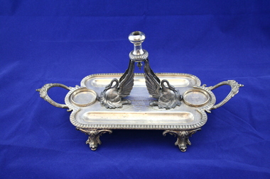
Silver plated pen and inkstand
Silver plated inkstand with two handles and four decorative legs, candle holder supported in middle by two swan figures presented to Joseph Bosisto but found in a houjse in Richmond next door to engineering shop owned by Melville Lobers (buried in Macclesfield) who is a relative of Mirren Alenson. Joseph Bosisto was a pharmaceutical chemist from Yorkshire, who set up eucalyptus distilleries at Emerald, Menzies Creek and Macclesfield in 1882. Joseph Bosisto was a Commissioner of the Melbourne International Exhibition 1880-1881 Presented to Joseph Bosisto Esq. M.L.A. by the employees of the Public Parks and Gardens 1882 -
 Clunes Museum
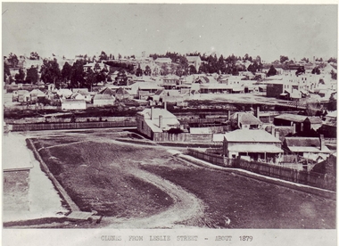
photograph
BLACK AND WHITE PHOTOGRAPH OF CLUNES TOWNSHIP TAKEN FROM IN THE VICINITY OF GEORGE STREET, LOOKING WEST - ONE ORIGINAL PHOTOGRAPH MOUNTED ON CARD AND 6 PHOTOCOPIES. ORIGINAL AND 2 COPIES SAY VIEW FROM LESLIE STREET. COPY MOUNTED ON CARD - VIEW FROM GEORGE STREET. 3 PHOTOCOPIES HAVE LESLIE STREET CHANGED TO GEORGE STREET. NOTE ON BACK OF .4 - CLUNES FROM LESLIE (CROSSED OUT) GEORGE ST , 1879 (CROSSED OUT) 1881 OR 2FROM GEORGE STREET. LOOKING WESTlocal history, photography, photographs, clunes township -
 Mission to Seafarers Victoria
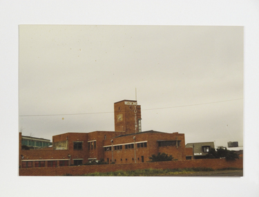
Photograph - Photograph, Colour, 1988
The photograph taken in 1988 before it was demolished shows the Art Deco style building also known as the King George V memorial Building, commissioned by merchant and philanthropist, Alfred Michael Nicholas (1881-1937) and designed by prolific Melbourne-based architect Harry A. Norris (1888-1966) in 1937 best known for his commercial work in Melbourne city centre. Architect Harry A Norris, one of Melbourne's early designers in the Moderne style had a strong relationship with the wealthy Nicholas family who made their fortune on the production of Aspro, a replacement for the German Aspirin when it was made unavailable during WWI. After the Nicholas Building on Swanson Street (1926), the Nicholas Factory in South Melbourne, and the mansion 'Burnham Beeches' in the Dandenongs (1931), the former Missions to Seamen building in Port Melbourne (1937) was a gift from Alfred Nicholas to the Church of England. “The new Institute will be a modern two story building in brick, with a high clock-tower, a memorial chapel, a hall for talking pictures, lounges, and billiard-rooms. It will stand in about an acre of ground between the two piers at Port Melbourne. The building of the mission has been made possible by a bequest of about£15,000 by the late Mr. A. M. Nicholas.” – The Argus 19th May, 1937. The building had a cruciform floor plan which contains a chapel, a large hall, other recreation rooms, sleeping accommodation on the first floor and a sundeck and living quarters for the chaplain and the caretaker. After being left derelict for years, it was demolished in 1994 to Colour photograph of Port Melbourne Missions to Seamen demolished in 1995.harry a. norris, alfred m. nicholas, art deco, 1937, missions to seamen, brick, king george v memorial building, 1988, zeitgeist, arts centre -
 University of Melbourne, Burnley Campus Archives
Plan - Photocopy, County, c.1930
Given to Archives by Emma Ferguson and Jo van Berkel who used it in preparation of their 1994 thesis on the history of the Burnley Gardens. Photocopy of a plan depicting Burnley College as it was in the 1930's. It shows the Pavilion and surrounding gardens, coops and yards, various small outbuildings. Shows the contours of the land in the northern section of the property bordering Swan St. Some additions and comments have been added to original document, mainly to do with sewerage and water supplyburnley college, pavilion, emma ferguson, jo van berkel -
![Public Works, Barry Street [Kew], 1955](/media/collectors/550653872162f11fb04854aa/items/586f97ffd0ce2307f0beee65/item-media/586f985ed0ce2307f0bf0aa6/item-fit-380x285.jpg) Kew Historical Society Inc
Kew Historical Society IncPhotograph, City of Kew, Public Works, Barry Street [Kew], 1955
Original photograph donated to the Kew Historical Society by the City's Engineering Department before the amalgamation of Kew into the City of Boroondara in 1994.This 1955 photograph provides a fine snapshot of the work of local government engineering departments in the 1950s. They reveal they types of labour conducted, the techniques used and the equipment and machinery in the possession of the local government authority.Trees in Barry Street, Kew. Barry Street, Kew, looking south to the intersection of Stawell Street. Inscription [pencil] B1955. Stamped: "Please quote No. Gx2320 when ordering. Laurie Richards JW 1528"barry street (kew), gutters, nature strips, street trees -
 Kew Historical Society Inc
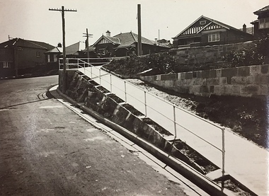
Photograph, City of Kew, Public Works, Road Making, c.1920s
An original photograph donated to the Kew Historical Society by the City's Engineering Department before the amalgamation of Kew into the City of Boroondara in 1994. While not all of the photographs are of Studley Park, Kew or East Kew, each photo provides a fine snapshot of the work of local government engineering departments of the period. They reveal they types of labour conducted, the techniques used and the equipment and machinery in the possession of the local government authority.Public works. A high retaining wall holds back an embankment on a steep slope around which a road turns. It is believed that the photograph dates from the 1920s. Inscription on reverse: "A difficult corner designed to obviate the use of steps. / Pedestrians using the road in front of the dwellings step off the pathway at the telegraph pole".city of kew (engineering department), engineering, road construction building -
 Kew Historical Society Inc
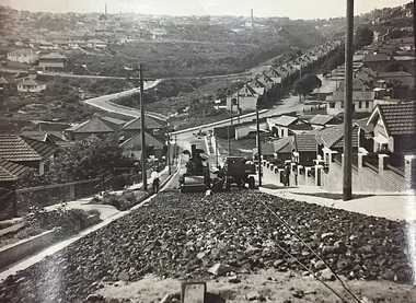
Photograph, City of Kew, Public Works, Road Construction, c. 1920s
An original photograph donated to the Kew Historical Society by the City's Engineering Department before the amalgamation of Kew into the City of Boroondara in 1994. While not all of the photographs are of Studley Park, Kew or East Kew, each photo provides a fine snapshot of the work of local government engineering departments of the period. They reveal they types of labour conducted, the techniques used and the equipment and machinery in the possession of the local government authority. Public works. A photograph of a suburban street under construction using a steamroller. The street was photographed to demonstrate the issues relating to grading. Neither the street nor the location has been identified. Inscription on reverse: "The construction of a roadway in a 1 in 3 1/2 grade. / The waggon is hauling the roller, by means of a cable attached to a pulley anchored at the top of the grade." engineering, city of kew (engineering department), road making construction -
 Kew Historical Society Inc
Photograph, City of Kew, Public Works, Road Construction, c.1920s
An original photograph donated to the Kew Historical Society by the City's Engineering Department before the amalgamation of Kew into the City of Boroondara in 1994.While not all of the photographs are of Studley Park, Kew or East Kew, each photo provides a fine snapshot of the work of local government engineering departments of the period. They reveal they types of labour conducted, the techniques used and the equipment and machinery in the possession of the local government authority. Public works. A photograph of a suburban street under construction using a steamroller. Neither the street nor the location has been identified. It is believed that the photograph can be dated to the 1920s. Inscription on reverse: "Road making. (?1920s cars)".steamroller, road construction building, city of kew, city of kew (engineering department) -
 Kew Historical Society Inc
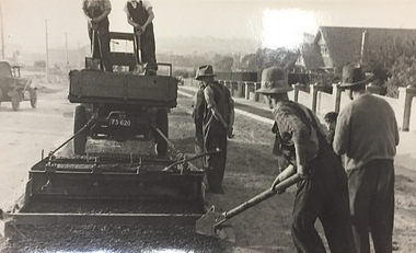
Photograph, City of Kew, Public Works, Road Construction, c.1920s
An original photograph donated to the Kew Historical Society by the City's Engineering Department before the amalgamation of Kew into the City of Boroondara in 1994.While not all of the photographs are of Studley Park, Kew or East Kew, each photo provides a fine snapshot of the work of local government engineering departments of the period. They reveal they types of labour conducted, the techniques used and the equipment and machinery in the possession of the local government authority. Public works. A close-up photograph of a grader being pulled by a truck. road construction building, city of kew, city of kew (engineering department), bituminising, grader -
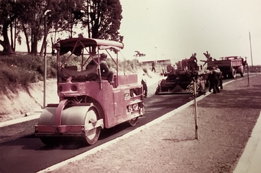
 Kew Historical Society Inc
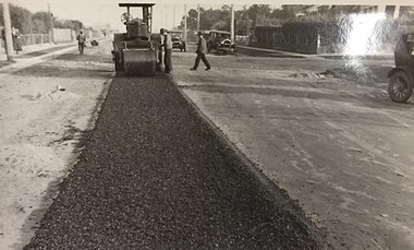
Photograph, Public Works, Road Construction, 1950s
An original photograph donated to the Kew Historical Society by the City's Engineering Department before the amalgamation of Kew into the City of Boroondara in 1994.While not all of the photographs are of Studley Park, Kew or East Kew, each photo provides a fine snapshot of the work of local government engineering departments of the period. They reveal they types of labour conducted, the techniques used and the equipment and machinery in the possession of the local government authority. Public works. Road making in the 1950s using a steam roller and a mechanical grader. Inscription on reverse: "Road making." city of kew (engineering department), road construction building, road maintenance -
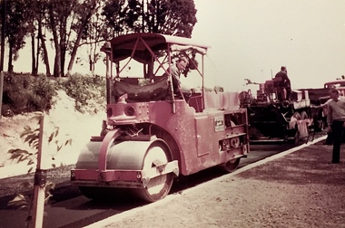
 Kew Historical Society Inc
Photograph, Public Works, Road Construction, 1950s
An original photograph donated to the Kew Historical Society by the City's Engineering Department before the amalgamation of Kew into the City of Boroondara in 1994.While not all of the photographs are of Studley Park, Kew or East Kew, each photo provides a fine snapshot of the work of local government engineering departments of the period. They reveal they types of labour conducted, the techniques used and the equipment and machinery in the possession of the local government authority.Public works. Road making in the 1950s using a steam roller and a mechanical grader. Inscription on reverse: "Road making." city of kew (engineering department), road construction -
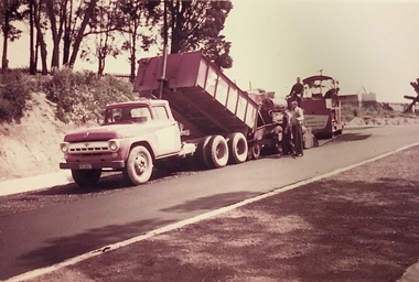 Kew Historical Society Inc
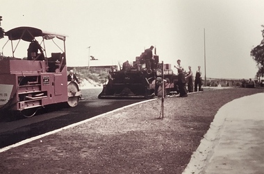
Photograph, Public Works, Road Construction, 1950s
An original photograph donated to the Kew Historical Society by the City's Engineering Department before the amalgamation of Kew into the City of Boroondara in 1994.While not all of the photographs are of Studley Park, Kew or East Kew, each photo provides a fine snapshot of the work of local government engineering departments of the period. They reveal they types of labour conducted, the techniques used and the equipment and machinery in the possession of the local government authority.Public works. Roadmaking machinery in the 1950s using a tip truck and other equipment. Inscription on reverse: "Road making. Date?" city of kew (engineering department), road construction maintenance -
 Kew Historical Society Inc
Photograph, Public Works, Road Construction, 1950s
An original photograph donated to the Kew Historical Society by the City's Engineering Department before the amalgamation of Kew into the City of Boroondara in 1994.While not all of the photographs are of Studley Park, Kew or East Kew, each photo provides a fine snapshot of the work of local government engineering departments of the period. They reveal they types of labour conducted, the techniques used and the equipment and machinery in the possession of the local government authority.Public works. Roadmaking in the 1950s using a steam roller. Inscription on reverse: "Road making. Date?" city of kew (engineering department), road construction building -
Bialik College
Album (Item) - "A Fractured Torah Tale", Bialik College, Theatre Production, 1993
Grade 2 and 3 theatre production for 1994, performed at Stonnington Theatre, Deakin University, Malvern. Performed on 1 December. judaism, bialik college, theatre production, 1990s -
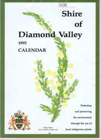 Greensborough Historical Society
Calendar, Shire of Diamond Valley, Shire of Diamond Valley 1995 Calendar, 1995_
Copies of this calendar were distributed to households in the Shire of Diamond Valley. This 1994 Calendar features images of indigenous plants painted by Jan Lowe. Includes a Guide to services provided by Shire of Diamond Valley. The Shire of Diamond Valley was a Local Government Area located about 20 kilometres northeast of Melbourne. The shire covered an area of 74.38 square kilometres and existed from 1964 until 1994.The annual calendar is a record of the activities and services in the former Shire of Diamond Valley.28 page calendar illustrated with images of local flora, with 16 page liftout "Shire of Diamond Valley Resource Guide"shire of diamond valley, shire of diamond valley calendar, jan lowe -
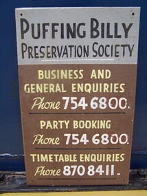 Puffing Billy Railway
Puffing Billy Preservation Society contact sign, pre 1977
Puffing Billy Preservation Society contact sign Contact details of the Puffing Billy Preservation Society on this sign were located at Belgrave in a prominent position. It dates to pre 1994, possibly pre 1977. The sign shows telephone numbers of seven digits in use before the current eight digits were introduced around 1994. The numbers shown here are no longer in use for the Puffing Billy Railway. Historic - Puffing Billy Preservation Society signPuffing Billy Preservation Society contact sign small wooden rectangle painted sign Puffing Billy Preservation Society Enquirespuffing billy, sign -
Glen Eira City Council History and Heritage Collection
Document (Item) - Newspaper (digital), Caulfield Contact, 1979
The Caulfield Contact was the official newspaper of the City of Caulfield from 1976-1994. The City of Caulfield was the Municipal Council for an area of the South Eastern suburbs of Melbourne, including Brighton East, Carnegie, Caulfield, Elsternwick, Gardenvale, Glen Huntly, McKinnon, Murrumbeena, Ormond and St Kilda East. Following Amalgamation of City of Caulfield and parts of the City of Moorabbin in 1994, the Caulfield Contact was followed by the Glen Eira News.city of caulfield, caulfield, glen eira, city of glen eira, caulfield contact -
Glen Eira City Council History and Heritage Collection
Document (Item) - Newspaper (digital), Caulfield Contact, 1980
The Caulfield Contact was the official newspaper of the City of Caulfield from 1976-1994. The City of Caulfield was the Municipal Council for an area of the South Eastern suburbs of Melbourne, including Brighton East, Carnegie, Caulfield, Elsternwick, Gardenvale, Glen Huntly, McKinnon, Murrumbeena, Ormond and St Kilda East. Following Amalgamation of City of Caulfield and parts of the City of Moorabbin in 1994, the Caulfield Contact was followed by the Glen Eira News.city of caulfield, caulfield -
Glen Eira City Council History and Heritage Collection
Document (Item) - Newspaper (digital), Caulfield Contact, 1981
The Caulfield Contact was the official newspaper of the City of Caulfield from 1976-1994. The City of Caulfield was the Municipal Council for an area of the South Eastern suburbs of Melbourne, including Brighton East, Carnegie, Caulfield, Elsternwick, Gardenvale, Glen Huntly, McKinnon, Murrumbeena, Ormond and St Kilda East. Following Amalgamation of City of Caulfield and parts of the City of Moorabbin in 1994, the Caulfield Contact was followed by the Glen Eira News.city of caulfield, caulfield -
Glen Eira City Council History and Heritage Collection
Document (Item) - Newspaper (digital), Caulfield Contact, 1982
The Caulfield Contact was the official newspaper of the City of Caulfield from 1976-1994. The City of Caulfield was the Municipal Council for an area of the South Eastern suburbs of Melbourne, including Brighton East, Carnegie, Caulfield, Elsternwick, Gardenvale, Glen Huntly, McKinnon, Murrumbeena, Ormond and St Kilda East. Following Amalgamation of City of Caulfield and parts of the City of Moorabbin in 1994, the Caulfield Contact was followed by the Glen Eira News.city of caulfield, caulfield -
Glen Eira City Council History and Heritage Collection
Document (Item) - Newspaper (digital), Caulfield Contact, 1983
The Caulfield Contact was the official newspaper of the City of Caulfield from 1976-1994. The City of Caulfield was the Municipal Council for an area of the South Eastern suburbs of Melbourne, including Brighton East, Carnegie, Caulfield, Elsternwick, Gardenvale, Glen Huntly, McKinnon, Murrumbeena, Ormond and St Kilda East. Following Amalgamation of City of Caulfield and parts of the City of Moorabbin in 1994, the Caulfield Contact was followed by the Glen Eira News.city of caulfield, caulfield -
Glen Eira City Council History and Heritage Collection
Document (Item) - Newspaper (digital), Caulfield Contact, 1984
The Caulfield Contact was the official newspaper of the City of Caulfield from 1976-1994. The City of Caulfield was the Municipal Council for an area of the South Eastern suburbs of Melbourne, including Brighton East, Carnegie, Caulfield, Elsternwick, Gardenvale, Glen Huntly, McKinnon, Murrumbeena, Ormond and St Kilda East. Following Amalgamation of City of Caulfield and parts of the City of Moorabbin in 1994, the Caulfield Contact was followed by the Glen Eira News.city of caulfield, caulfield -
Glen Eira City Council History and Heritage Collection
Document (Item) - Newspaper (digital), Caulfield Contact, 1985
The Caulfield Contact was the official newspaper of the City of Caulfield from 1976-1994. The City of Caulfield was the Municipal Council for an area of the South Eastern suburbs of Melbourne, including Brighton East, Carnegie, Caulfield, Elsternwick, Gardenvale, Glen Huntly, McKinnon, Murrumbeena, Ormond and St Kilda East. Following Amalgamation of City of Caulfield and parts of the City of Moorabbin in 1994, the Caulfield Contact was followed by the Glen Eira News.city of caulfield, caulfield -
Glen Eira City Council History and Heritage Collection
Document (Item) - Newspaper (digital), Caulfield Contact, 1986
The Caulfield Contact was the official newspaper of the City of Caulfield from 1976-1994. The City of Caulfield was the Municipal Council for an area of the South Eastern suburbs of Melbourne, including Brighton East, Carnegie, Caulfield, Elsternwick, Gardenvale, Glen Huntly, McKinnon, Murrumbeena, Ormond and St Kilda East. Following Amalgamation of City of Caulfield and parts of the City of Moorabbin in 1994, the Caulfield Contact was followed by the Glen Eira News.city of caulfield, caulfield -
Glen Eira City Council History and Heritage Collection
Document (Item) - Newspaper (digital), Caulfield Contact, 1987
The Caulfield Contact was the official newspaper of the City of Caulfield from 1976-1994. The City of Caulfield was the Municipal Council for an area of the South Eastern suburbs of Melbourne, including Brighton East, Carnegie, Caulfield, Elsternwick, Gardenvale, Glen Huntly, McKinnon, Murrumbeena, Ormond and St Kilda East. Following Amalgamation of City of Caulfield and parts of the City of Moorabbin in 1994, the Caulfield Contact was followed by the Glen Eira News.city of caulfield, caulfield -
Glen Eira City Council History and Heritage Collection
Document (Item) - Newspaper (digital), Caulfield Contact, 1988
The Caulfield Contact was the official newspaper of the City of Caulfield from 1976-1994. The City of Caulfield was the Municipal Council for an area of the South Eastern suburbs of Melbourne, including Brighton East, Carnegie, Caulfield, Elsternwick, Gardenvale, Glen Huntly, McKinnon, Murrumbeena, Ormond and St Kilda East. Following Amalgamation of City of Caulfield and parts of the City of Moorabbin in 1994, the Caulfield Contact was followed by the Glen Eira News.city of caulfield, caulfield -
Glen Eira City Council History and Heritage Collection
Document (Item) - Newspaper (digital), Caulfield Contact, 1989
The Caulfield Contact was the official newspaper of the City of Caulfield from 1976-1994. The City of Caulfield was the Municipal Council for an area of the South Eastern suburbs of Melbourne, including Brighton East, Carnegie, Caulfield, Elsternwick, Gardenvale, Glen Huntly, McKinnon, Murrumbeena, Ormond and St Kilda East. Following Amalgamation of City of Caulfield and parts of the City of Moorabbin in 1994, the Caulfield Contact was followed by the Glen Eira News.city of caulfield, caulfield, caulfield contact -
 Glen Eira City Council History and Heritage Collection
Document (Series) - Newspaper (digital), Caulfield Contact
Generated by Caulfield City Council, transferred to Glen Eira City Council at Amalgamation.Newsletter for City of CaulfieldBy Year then by Edition/MonthThe Caulfield Contact was the official newspaper of the City of Caulfield from 1976-1994. The City of Caulfield was the Municipal Council for an area of the South Eastern suburbs of Melbourne, including Brighton East, Carnegie, Caulfield, Elsternwick, Gardenvale, Glen Huntly, McKinnon, Murrumbeena, Ormond and St Kilda East. Following Amalgamation of City of Caulfield and parts of the City of Moorabbin in 1994, the Caulfield Contact was followed by the Glen Eira News.brighton east, carnegie, caulfield, elsternwick, gardenvale, glen huntly, mckinnon, murrumbeena, ormond, st kilda east, saint kilda east, east brighton, east st kilda, east saint kildabrighton east, carnegie, caulfield, elsternwick, gardenvale, glen huntly, mckinnon, murrumbeena, ormond, st kilda east, saint kilda east, east brighton, east st kilda, east saint kilda -
Glen Eira Historical Society
Document - Caulfield City Rifle Club No. 119, 294 Glen Huntly Road, Elsternwick
A two page black and white photocopy of a report from the Caulfield Conservation Study on 294 Glen Huntly Road, Caulfield City Rifle Club by Andrew Ward, 09/1994. The report includes a description of the exterior of the property, a brief overview of the history of the building and a statement of its significance. It also includes a black and white photograph (150mm x 100mm) of the exterior of the building, dated 09/1994.caulfield conservation study, architectural features, glen huntly road, ward andrew, caulfield city rifle club, pavey p a -
 Kew Historical Society Inc
Document - Urban Planning Document, City of Kew, City of Kew : Minimum Size of Allotment Required, 1945-1955
A document outlining the relevant by-laws produced by the City Of Kew to regulate the minimum size of allotments in Barkers Road, Burke Road, Cotham Road, Glenferrie Road and Studley Park Road, as well as in other streets more generally. The by-laws specify the size of allotments in which single unit dwellings, attached houses and maisonettes, and flats could be built. In the ‘main streets’ a minimum land area for single unit dwellings was 8,100 square feet, with an average frontage of 60’ and a depth of 135’. In other streets this was reduced to an overall size of 6,250 square feet, with an average dimensions of 50’ x 125’. In specifying the land area required by flats, different sizes were regulated for the construction of between two and six flats. Six flats at the time when the regulations were passed must have been the upper limit permitted. Understanding the size of land listed in imperial measurements can be a challenge. Within Australia, the so-called quarter acre block was approximately 11,000 square feet. Those specified in the by-laws would appear to be smaller. The document was pasted on the reverse of a subdivision plan in the collection.This is a rare (undated) document produced by the City of Kew defining how subdivision within the municipality should occur. The document was created to constrain unbridled speculation in subdivisions in the various parts of Kew and East Kew.Undated typed document, issued by the City of Kew (1921-1994) indicating the minimum size of allotment required in Barkers Road, Burke Road, Cotham Road, Glenferrie Road and Studley Park Road. The document is mounted on board and waterstained. It was presumably used by a real estate agent. [Formerly catalogued as MAP.0066].city of kew - by-laws and regulations, subdivisions - kew - studley park