Showing 10987 items matching "land "
-
 City of Moorabbin Historical Society (Operating the Box Cottage Museum)
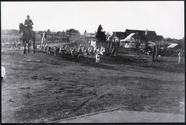
Photograph, Black & White Oakleigh Hunt Club in Jasper Rd c 1920, c1920
The Melbourne Hunt Club was founded by Mr George Watson in 1852 with hounds brought to Australia from Ireland and moved its headquarters a number of times as the city grew between 1897 and 1929, The kennels were originally at Kirk's Bazaar, in Bourke Street, Melbourne, subsequently they moved to St Kilda, Caulfield, Deer Park, Oakleigh, Cranbourne and finally to their current location in Packenham. Oakleigh was the favoured spot, mainly because of the railway and the unloading ramp at the station. Riders and horses arrived on special trains and hunted over the surrounding market gardens, but not without friction. After 1929, significant numbers of Hunt Club members had access to motorized horse transport and besides, Oakleigh was becoming too built up. The Hunt Club moved on to Cranbourne The club maintains the oldest continual pack of hounds in Australia. The Melbourne Hunt Club was founded 1852 by George Watson and imported foxhounds from Ireland. As the Melbourne suburbs spread the Club moved several times. 1920 it was in Oakleigh and now is possibly situated in Packenham Black & White photograph showing men riding horses with a pack of hounds coming down a dirt road . Houses and vacant land in backgroundwatson george, oakleigh, melbourne hunt club, smith j l; smith mary ann, stanley helen, smith vic, smith harry redvers, chaff cutter, horse drawn carts, toll gates brighton, motor cars 1900, steam engines, early settlers, bentleigh, parish of moorabbin, city of moorabbin, county of bourke, moorabbin shire, king richard, charman s, highett william, ormond francis, maynard dennis, market gardeners, vineyards, orchards -
 Bendigo Historical Society Inc.
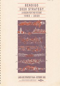
Document - VERN ROBSON COLLECTION: BENDIGO 2020 STRATEGY, October, 1993
Document, 92 pages bound, 'Bendigo 2020 Strategy, a vision for the future, 1993 - 2020' Land use strategy plan - October 1993.bendigo, council, city of greater bendigo -
 Bendigo Historical Society Inc.
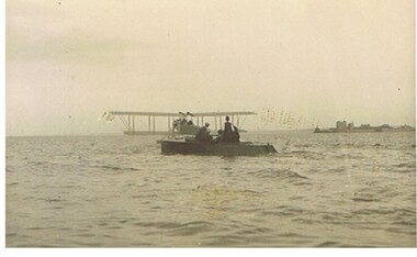
Postcard - BASIL WATSON COLLECTION: BIPLANE ON WATER
Postcard: sepia coloured card. Biplane floating on water, men in boat in foreground. On RH side of photo in distance buildings on spit of land.A. Rapp, marine photographeraviation, civilian, biplane, basil watson, biplane, aeroplane -
 Bendigo Historical Society Inc.
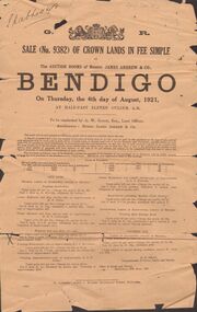
Document - ABBOTT COLLECTION: CROWN LAND SALE ADVERTISEMENT
Document : Crown Land Sale, 4th. August, 1921, advertising flyer. Magazine site in Golden Square is marked with a blue cross for identification.bendigo, industry, abbott & co., abbott, j.h., abbott, h.a., bendigo, industry, retail, hardware -
 Whitehorse Historical Society Inc.
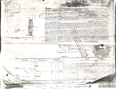
Document - Land Title, David Boyle, 28/11/1873
Titles Office photocopy of Land Title granted to David Boyle in Canterbury Road, Forest Hill, originally granted on 28 November 1873.boyle, david, canterbury road, forest hill, land sales -
 Whitehorse Historical Society Inc.
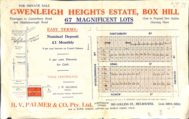
Document, Gwenleigh Heights Estate, Box Hill, unknown
Land plan of 67 allotments for sale between Canterbury Road, Middleborough Road and Agnew Street, Box Hill. (Now Blackburn South)land subdivision, middleborough road, blackburn south, canterbury road, agnew street, aberdeen road, h. v. palmer (estate agent) -
 Whitehorse Historical Society Inc.
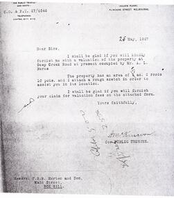
Document - Letter, Schwerkolt Family, 27/05/1957
Letter from Public Trustee about inspection of land at Schwerkolt Cottage which had fallen into disrepair. Value of property was 430 pounds.land values, schwerkolt cottage, burns, a.r., public trustee, deep creek road, mitcham -
 Whitehorse Historical Society Inc.
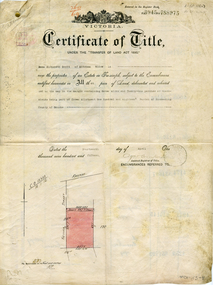
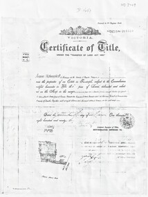
Legal record - Document, Certificate of Title - Scott, 14/04/1915 12:00:00 AM
Certificate of Title dated 14/4/1915 in the name of Emma Elizabeth Scott.Certificate of Title dated 14/4/1915 in the name of Emma Elizabeth Scott. Land bounded by Victoria Street and Scott Street, MitchamCertificate of Title dated 14/4/1915 in the name of Emma Elizabeth Scott.land titles, scott, emma elizabeth, scott street, mitcham, victoria street -
 Whitehorse Historical Society Inc.
Programme - Document, Centenary Mass at St John's School, Mitcham, 22/05/1988
Program of Centenary Mass for St John's School, Mitcham. Included is a short history of the school commenced 1872 on land donated by William McGlone.catholic schools, st johns catholic school, mitcham, mcglone, william -
Whitehorse Historical Society Inc.
Newspaper, Pre-School All Set To Get A New Home, 1/03/1996 12:00:00 AM
Whitehorse Council has reached in-principle agreement to lease land at Vermont Primary School to Vermont Pre-School and build a Centre for it on the site.Whitehorse Council has reached in-principle agreement to lease land at Vermont Primary School to Vermont Pre-School and build a Centre for it on the site.Whitehorse Council has reached in-principle agreement to lease land at Vermont Primary School to Vermont Pre-School and build a Centre for it on the site.schools, vermont preschool, vermont primary school, no. 1022, city of whitehorse, oscar, geoff, wallace, marie, ward, peter -
Whitehorse Historical Society Inc.
Document, Open space between Yarran Dheran and Schwerkolt Cottage, 2001
Report of an open space assessment by Melbourne Parks and Waterways land between Yarran Dheran and Schwerkolt Cottage.Report of an open space assessment by Melbourne Parks and Waterways land between Yarran Dheran and Schwerkolt Cottage. Council Paper PROP/016781Report of an open space assessment by Melbourne Parks and Waterways land between Yarran Dheran and Schwerkolt Cottage. yarran dheran, nunawading and district historical society inc., schwerkolt cottage -
Whitehorse Historical Society Inc.
Legal record - Land Title, Certificate of Title, 1968
Certificate of Title to Roger Robert Charles Jeanne De Stoop and Wivine Marie de Stoop for land in Joseph Street Blackburn North.Certificate of Title to Roger Robert Charles Jeanne De Stoop and Wivine Marie de Stoop for land in Joseph Street Blackburn North.Certificate of Title to Roger Robert Charles Jeanne De Stoop and Wivine Marie de Stoop for land in Joseph Street Blackburn North.de stoop, wivine, de stoop, roger, joseph street blackburn north, land titles -
 Whitehorse Historical Society Inc.
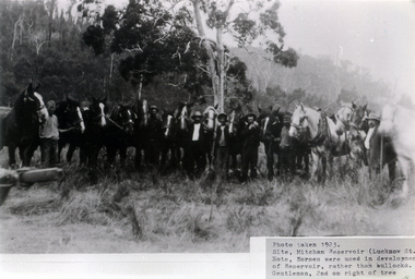
Photograph, Mitcham Reservoir
Photo of Teams of Horses used for clearing land for the Melbourne and Metropolitan Board of Works reservoir at Mitcham. (Copy of framed Photo see NP842).melbourne and metropolitan board of works, mitcham reservoir -
 Whitehorse Historical Society Inc.
Legal record - Document, Benno Schwerkolt, 01/03/1893
Certificate of Title issued to Carl Benno Schwerkolt for land in Edgerton Road, Mitcham dated 20 Mar 1893A photocopy of certificate of Title issued to Carl Benno Schwerkolt for land in Edgerton Road, Mitcham dated 20 Mar 1893 and successive transfers.Certificate of Title issued to Carl Benno Schwerkolt for land in Edgerton Road, Mitcham dated 20 Mar 1893 schwerkolt, carl benno, land titles -
 Rutherglen Historical Society
Image, Olive Codling
Photo was taken by Miss Olive Codling, who was a life member of the Wodonga Historical Society. Photograph is believed to have been taken on the occasion of a Tour of Mt Ophir winery by the North East Branch, 1st combined meeting.Black and white photograph of a rural area with gold mining mullock heaps in the background. In the foreground is a shallow depression that appears to be a dried wet-land.Written on back of photo: "Rutherglen | Wod. Hist. Soc. | 1st N. E. Region Meeting?"mt ophir, mount ophir, gold mining, mullock heaps -
 Mt Dandenong & District Historical Society Inc.
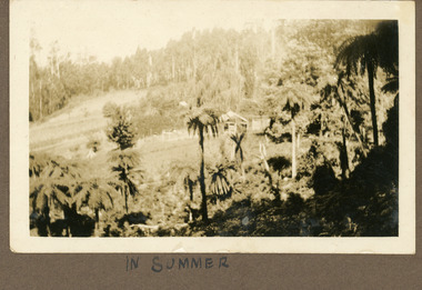
Photograph
The photograph is from the album of Ivy Child. It shows the homestead where she lived with her parents Ted and Ethel Child. The photograph is presumably taken during the summer. Ivy May Child (1910 – 1989) was the daughter of Arthur Edward (Ted) Child (1878 – 1964) and Ethel May Madden (1888 – 1970). Ted Child was the son of Matthew Francis Child (1839 – 1933) and Martha Jeeves (1857 – 1926). He was the grandson of one of the early pioneers Francis Child. Ivy grew up on the family property on Childs Road and took many photographs. Most of these are glued into her photo album. The album covered the years from c1927 – 1932. Ivy married Henry William Burgess (1906 – 1968) in 1944. The photographs remain in their original state in the album with individual copies made. Sepia photograph with tree ferns in the foreground. A homestead with fence is just visible in the centre with cleared land beyond rising up to thick bush.Handwritten below photograph in album: IN SUMMERivy child, child, homestead, kalorama, summer, tree fern -
 Old Colonists' Association of Ballarat Inc.
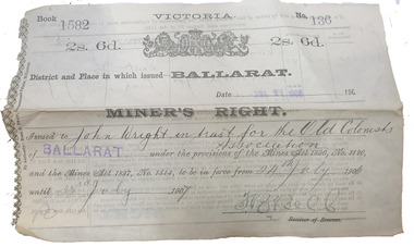
Document, Miners' Right issued to John Wiight in Trust for the Old Colonists' Association of Ballarat, 21/07/1906
A miners' right issued to John Wiight in Trust for the Old Colonists' Association of Ballarat. The land under Miners' Right was in Humffray Street South.miners' right, ballarat old colonists' association, john wright, humffray street south -
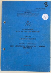 8th/13th Victorian Mounted Rifles Regimental Collection
Book - APC Manual
Blue soft cover book " Australian Army Manual of Land Warfare Part two Armour Training. The Armoured Personnel Carrier Regiment " apc, armour, army, reserve -
 Sunbury Family History and Heritage Society Inc.
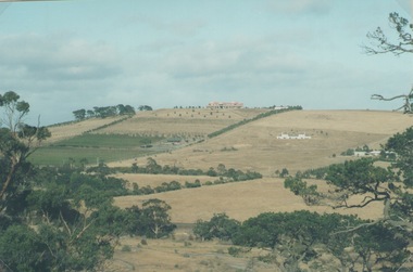
Photograph, Sue Palmer, Landscape, March 2001
The photograph was part of a collection from a photograph competition organised bye the Sunbury & District Heritage Association in March 2001. It is a view of the former vineyard growing area in Sunbury which was situated along Vineyard Road. One of the remaining vineyards is visible in the photo. From 1860 to the early 1900s many vineyards were operating in Sunbury. The east facing slopes along Vineyard Road were suitable for vine growing as was the flats along Jacksons Creek.A non-digital coloured landscape photograph of a hillside showing some cultivation and grazing land and three houses as well as some native trees. sunbury, vineyards, wine production -
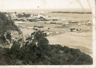 Lakes Entrance Historical Society
Postcard - Township, 1930c
Black and white small format postcard showing the township situated on the land between the Cunninghame Arm and North Arm. Lakes Entrance VictoriaLakes Entrance from Princes Highway (on back)bridges, township, topography, waterways -
University of Melbourne, Burnley Campus Archives
Newspaper - Newspaper Cutting, The Leader, Royal Horticultural Society's Autumn Show, 1942
Full page of "The Leader" April 8, 1942 p12. Collage of photographs includes one of A.W. Jessep with members of the Women's Land Army.burnley school of horticulture, a.w. jessep, women's land army, royal horticultural society, rhsv, dahlias, garden show -
Lakes Entrance Historical Society
Book, Le Cheminant, Marion, Nyerimilang, 1999
A short history of the Victorian State Park, Nyerimilang, on the Gippsland Lakes, from selection of the land to acquisition by Parks Victoria and formation of Friends of Nyerimilang.parks, settlers, waterways -
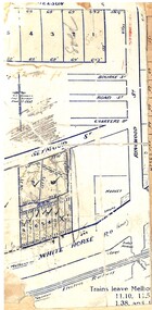
 Ringwood and District Historical Society
Document, Plan of Subdivision - Part of Crown Portion 5, Parish of Ringwood, County of Bourke - (Undated)
Map showing layout of 4 numbered allotments coloured red and land coloured blue appropriated or set aside for drainage and sewerage puposes.Map includes Nelson Street and Ringwood Street, Ringwood, Vic. -
 Ringwood and District Historical Society
Map, Partially trimmed copy of a retail and residential auction advertisement, Ringwood, Vic. - 1926
One of 3 unrelated land subdivision maps on cardboard backing. Numbered allotments on Nelson Street, Seymour Street and Whitehorse Road, Ringwood.W.J. Bonwick, Licensed Surveyor, Phone WU4830. Location map also includes Bourke Street, Bond Street, Charter Street, Ringwood Street, and Shops and Market sites in Ringwood. -
 Lakes Entrance Historical Society
Postcard - View of Bruthen, W S Vogt Bairnsdale, 1918 c
Black and white postcard showing township, roads and rail, bridges and barked trees with cultivated land beside Tambo River Bruthen VictoriaTambo River at Bruthentownship, bridges, roads and streets -
 Whitehorse Historical Society Inc.
Photograph, Highland Avenue Mitcham, No.38
Three coloured photographs of the clearing of 38 Highland Avenue, Mitcham in 2006. This is the last piece of land that was originally part of Cherry Tree Farmcherry tree farm, mitcham, highland avenue, no.38, farming -
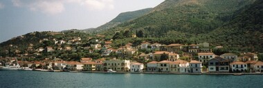 Ithacan Historical Society
Photograph, Port of Vathi
Vathi is the main town on the Island of Ithaca, built around the natural harbour. The architecture of the town shows the influence of Venetians who ruled the island from c1500 till 1797, following which the island was ruled briefly by the French and then became a British Protectorate until unification with Greece in 1864. The original venetian style buildings were mainly destroyed in the devastating earthquakes of 1953. However, the style of building has been retained and building regulations on the island require all new buildings to adhere to the traditional architecture of the island. A coloured panoramic view of the port of Vathi. The buildings have been built along a narrow strip of coastal land at the foot of the mountain range. -
 Bayside Gallery - Bayside City Council Art & Heritage Collection
Photograph, Department of Crown Lands and Survey, Victoria, Melbourne Project: Brighton and Elwood, 1976
The Department of Crown Lands and Survey (1857-1983) was responsible for the administration of survey and mapping and the sale, occupation and management of crown land throughout its existence. This aerial photograph shows parts of Brighton and Elwood and was taken on 1 December 1976brighton, elwood, department of crown lands and survey, aerial photograph, elsternwick park, point ormond, north road, ormond esplanade, st kilda street, glen huntly road, bayside, port phillip bay, map, cartographic material, melbourne project 1976 -
 Bendigo Historical Society Inc.
Document - H.A. & S.R. WILKINSON COLLECTION: CONTRACT OF SALE
Conditions of sale by private contract dated 22nd August, 1934 between A.E.A. Ogilvie (seller) and J.L. Samson (buyer) for land situate Maple Street, Golden Square, at present occupied by the vendor, being the land described in certificate of registration residence area No. 30186, together with building on the said land. Price 60 pounds. Also a letter signed by A. Ogilvie to Mr. H.A. Wilkinson to pay Mr. J.L.Samson the sum of 1 pound and 1 shilling from proceeds of sale of property in Maple Street, the letter is dated 5th September, 1934.organization, business, h.a. & s.r wilkinson real estate -
 Bendigo Historical Society Inc.
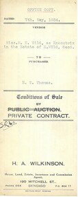
Document - H.A. & S.R. WILKINSON COLLECTION: CONTRACT OF SALE
Conditions of sale by private contract dated 7th May, 1934 between Miss M.H. Wild as executrix in the estate of E. Wild deceased (seller) and E.T. Thomas (buyer) for land situate Hargreaves Street corner Wattle Street, Bendigo being Crown allotment 25 section 97C described in certificate of title volume 1562 folio 332318. Also that piece of land adjoining above being land described in residence area certificate No.30319 in the books of the mining registrar at Bendigo. Together with 6-roomedweatherboard dwelling and all sundry. Price 350 pounds.organization, business, h.a. & s.r wilkinson real estate