Showing 2090 items
matching mountain
-
 Marysville & District Historical Society
Flyer (item) - Information flyer, Artworkz Tourism, Marysville-Cora Lynn Falls, 20-04-2018
A flyer that was produced as a guide to the Cora Lynn Falls near Marysville in Victoria.A flyer that was produced as a guide to the Cora Lynn Falls near Marysville in Victoria. These falls are located on the Marysville-Wood's Point Road. Cambarville is notable for its giant mountain ash (Eucalyptus regnans) trees within the Cumberland Memorial Scenic Reserve, and relics from former sawmills and gold mining. The Big Culvert is located nearby on the Marysville - Woods Point Road, which was historically part of the Yarra Track. Cambarville was established as a timber mill town in the 1940s. Timber mill owners A Cameron and FJ Barton named Cambarville. They established the mill to salvage timber from trees destroyed in the 1939 bushfires. Cambarville was impacted by the 2009 Black Saturday bushfires and any remaining structures were destroyed.marysville, victoria, photograph, cora lynn falls, waterfalls, cambarville, marysville-wood's point road, eucalyptus regnans, cumberland memorial scenic reserve, mining, big culvert, yarra track, a cameron, fj barton, 1939 bushfires, 2009 black saturday bushfires, timber mills -
Marysville & District Historical Society
Booklet (item) - Information booklet, Artworkz Tourism, Cora Lynn Falls, Unknown
An information booklet that was produced as a guide to the Cora Lynn Falls near Marysville in Victoria.An information booklet that was produced as a guide to the Cora Lynn Falls near Marysville in Victoria. These falls are located on the Marysville-Wood's Point Road. Cambarville is notable for its giant mountain ash (Eucalyptus regnans) trees within the Cumberland Memorial Scenic Reserve, and relics from former sawmills and gold mining. The Big Culvert is located nearby on the Marysville - Woods Point Road, which was historically part of the Yarra Track. Cambarville was established as a timber mill town in the 1940s. Timber mill owners A Cameron and FJ Barton named Cambarville. They established the mill to salvage timber from trees destroyed in the 1939 bushfires. Cambarville was impacted by the 2009 Black Saturday bushfires and any remaining structures were destroyed.marysville, victoria, photograph, cora lynn falls, waterfalls, cambarville, marysville-wood's point road, eucalyptus regnans, cumberland memorial scenic reserve, mining, big culvert, yarra track, a cameron, fj barton, 1939 bushfires, 2009 black saturday bushfires, timber mills -
Marysville & District Historical Society
Flyer (item) - Information flyer, Artworkz Tourism, Marysville-Cumberland Waterfall, Unknown
A flyer that was produced as a guide to the Cumberland Falls near Marysville in Victoria.A flyer that was produced as a guide to the Cumberland Falls near Marysville in Victoria. These falls are located on the Marysville-Wood's Point Road. Cambarville is notable for its giant mountain ash (Eucalyptus regnans) trees within the Cumberland Memorial Scenic Reserve, and relics from former sawmills and gold mining. The Big Culvert is located nearby on the Marysville - Woods Point Road, which was historically part of the Yarra Track. Cambarville was established as a timber mill town in the 1940s. Timber mill owners A Cameron and FJ Barton named Cambarville. They established the mill to salvage timber from trees destroyed in the 1939 bushfires. Cambarville was impacted by the 2009 Black Saturday bushfires and any remaining structures were destroyed.marysville, victoria, photograph, waterfalls, cumberland falls, p. 2328, rose series postcard, souvenir, rose stereograph company, cambarville, marysville-wood's point road, mountain ash, eucalyptus regnans, cumberland memorial scenic reserve, mining, timber milling, big culvert, a cameron, fj barton, black saturday bushfires -
Marysville & District Historical Society
Booklet (item) - Information Booklet, Artworkz Tourism, Cumberland Falls, Unknown
An information booklet that was produced as a guide to the Cumberland Falls near Marysville in Victoria.An information booklet that was produced as a guide to the Cumberland Falls near Marysville in Victoria. These falls are located on the Marysville-Wood's Point Road. Cambarville is notable for its giant mountain ash (Eucalyptus regnans) trees within the Cumberland Memorial Scenic Reserve, and relics from former sawmills and gold mining. The Big Culvert is located nearby on the Marysville - Woods Point Road, which was historically part of the Yarra Track. Cambarville was established as a timber mill town in the 1940s. Timber mill owners A Cameron and FJ Barton named Cambarville. They established the mill to salvage timber from trees destroyed in the 1939 bushfires. Cambarville was impacted by the 2009 Black Saturday bushfires and any remaining structures were destroyed.marysville, victoria, photograph, waterfalls, cumberland falls, p. 2328, rose series postcard, souvenir, rose stereograph company, cambarville, marysville-wood's point road, mountain ash, eucalyptus regnans, cumberland memorial scenic reserve, mining, timber milling, big culvert, a cameron, fj barton, black saturday bushfires -
Marysville & District Historical Society
Document (item) - Word document, Rene de Koning, The Cumberland Giant Tree, 09-11-2022
An account of the early history of the Cumberland Giant Tree near Marysville in Victoria.An account of the early history of the Cumberland Giant Tree near Marysville in Victoria. The Big Tree was, at one stage, known to be the tallest hardwood tree in the world standing at 92 meters (301ft, 6 inches). However, it was reduced to 84 meters by a wind storm in 1959. It is a mountain ash. There is a walking track through the forest to the Big Tree.big tree, mountain ash, cambarville, victoria, marysville -
 Marysville & District Historical Society
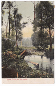
Postcard (item) - Colour postcard, Nicholas John Caire, Brook Scene at Marysville, 1906
One of a series of postcards of photographs taken by socialite photographer Nicholas John Caire. N.J. Caire had a great love for the area and in the late 1800's took many photographs of Marysville and its surrounds.One of a series of postcards of photographs taken by socialite photographer Nicholas John Caire. N.J. Caire had a great love for the area in and surrounding Marysville and in the late 1800's took many photographs of Marysville and its surrounds. N.J. Caire was born in 1837 in Guernsey. He arrived in Adelaide about 1860 along with his parents who encouraged his early interest in photography. He opened a studio in Adelaide in 1867 after traveling extensively throughout the Gippsland taking photographs. After marrying in 1870 he moved to Talbot in Victoria until 1876 when he opened a studio in the Royal Arcade in Melbourne. After 1885 N.J. Caire gave up his city work and made his home in South Yarra and devoted the rest of his life to outdoor photography, specializing in the bush, the gullies and the mountains of south-eastern Victoria. POST CARD This Space may be used for Correspondence. (FOR ADDRESS ONLY) Postmark/ Geelong/ 22/ Rest is illegible Glad to know you/ are keeping better/ & trust you will go/ on so doing accept/ love & best wishes/ for a happy Xmas/ we will be all/ thinking of you/ Yours M.P. Philip Mip Rittocto/ "Hospital"/ Lt Ryrie St/ Geelongmarysville, victoria, nicholas john caire, brook scene, souvenir, postcard -
 Marysville & District Historical Society
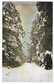
Postcard (item) - Colour postcard, Tommy's Bend, in the Snow, Marysville, Unknown
A colour postcard of Tommy's Bend, Marysville in Victoria taken during winter.A colour postcard of Tommy's Bend, Marysville in Victoria taken during winter. Tommy's Bend is a stretch of road 10 kilometres from Marysville on the Woods Point Road up to Lake Mountain.POST CARD Printed in Australia Stamp/ Here This space may be used for Correspondence/ within the Commonwealth without/ extra postage THIS SPACE FOR NAME AND/ ADDRESSmarysville, tommy's bend, winter, marysville-wood's point road, postcard, souvenir -
Marysville & District Historical Society
Article (item) - Newspaper article, The Alexandra and Eildon Standard, Indigenous history in the shire after colonisation, 08-03-2017
A newspaper article regarding indigenous history in the Murrindindi Shire after colonisation of the region.A newspaper article regarding indigenous history in the Murrindindi Shire after colonisation of the region.Wednesday, March 8, 2017alexandra, kulin, taungurung, goulburn, woi wurrung, yarra, acheron river, little river, dandenong ranges, land board, aboriginal guardian, william thomas, aboriginal station, lands minister, acheron station, mohican run, rubicon river, cathedral mountain, john green, mohican station, upper yarra, yarra tribe, woori yallock, hoddles creek, yarra river, badger creek, healesville, coranderrk, christmas bush, prostanthera lasianthos, black's spur -
Marysville & District Historical Society
Document (item) - Gold Mine Prospectus, Messrs Bruce & Robinson, Prospectus-Chester & Locke's Golden Secret Gold Mining Company, 1899
A copy of the prospectus for the Chester & Locke's Golden Secret Mining Company near Marysville in Victoria.A copy of the prospectus for the Chester & Locke's Golden Secret Mining Company near Marysville in Victoria. The Golden Bower gold mine was a quartz reef mine. William Edward Chester discovered the Golden Secret gold vein which became part of the Golden Bower Mine at Chesterville near Donovans Creek on the Cumberland goldfield which he mined with George Locke until the late 1930s. FOR PRIVATE CIRCULATIONshare prospectus, chester & locke's golden secret mining company, marysville, victoria, yarra track, upper yarra district, david newell, j.g. aikman, w.j. mountain, andrew barrie, gold mining, messrs w.p. jones and co., william chester, george locke, chesterville -
Marysville & District Historical Society
Document (Item) - Report, John F. Waghorn, Yarra Track, Unknown
A report on the history of the Yarra Track by John Waghorn, a local amateur historian.A report on the history of the Yarra Track by John Waghorn, a local amateur historian. John Waghorn was an amateur historian, an authority on the history of Victoria's postal services. He could tell you how mail was delivered in the high country in the 1880s, where the town of Gobur was, or when the overland Melbourne-Sydney mail service began. He admitted that his hobby has got a little out of hand. He had 30 filing cabinets, and indexes of more than 70,000 postal workers over the past 160 years crammed into three rooms at his home. If an ancestor was a postmaster in a Victorian town, he may have been able to reveal the person's occupation, income and working conditions.yarra track, john waghorn, victoria's postal services, wood's point, sydney road, longwood, merton, mansfield, postmasters, bonnie doon, melville merton mansfield, eltham, healesville, marysville, walhalla, melbourne-warburton-wood's point line, loose bags, heidelberg post office, eltham post office, kangaroo ground post office, yarra glen post office, marysville post office, healesville post office, mansfield post office, jamieson post office, gaffney's creek post office, wood's point post office, postal department, george rieck, stockman, jones, beecher, stockman's reward, big river, mary mcdonald, upper yarra river, donovan's creek, cornelius donovan, bridget buggy, matlock, alexandra, william farrell, jordan diggings, new chum, watts river, black spur, narbethong, granton, acheron river, mount strickland, paradise plains, mount grant, mount arnold, jordan goldfields, william robley, robley's spur, big river crossing, great dividing range, cumberland valley, james mcguigan, w elliot, christopher harrison, james marsh, cobb and co, box hill, lilydale, fehrings, koehlers, shaws, bear creek, cairnsville, cumberland creek, walkers, golden bower mine, collins' mountain home hotel, walsh's creek post office, rosa mcveigh, frank barton, hitchins, matthew kennedy, william morris, e r nichols, t woods, tom burchell, peter kerr, henry kuyper, william podlech, george koehler, henry brockmann, henry petty, thomas smith, jacob butchart, john perry, slingsby davis, royal mail hotel, walter gray, john summers, travellers rest hotel, lockington, the oaks, the springs, st clair, thomas crawford, springvale hotel, john sinclair, saint clair hotel, gould, mathews, willie we have missed you hotel, germany, johan fehring, adelaide, linton, ballarat, gunbower, murray river, anna katerina fehring, 1890s depression, land boom, fehring place, fred baker, alf sparke, fehring's hotel, mcveigh's hotel, wood's point mountaineer, l cox, victorian country directories, letson cox, coburg, maria hayes, setson, fitzroy, richmond, john cox, jordan river, jericho, e. norris, le poidevin, newell, o'brien, alhambra, sinclair, parker, ellis, tripp, quin, vernon, thompson, charsley, james fahie, george locke, william chester, chesterville, kirwan, cumberland reserve, blue spruce, e.s. and a bank, selby joyce, selby charles joy, selby joseph joyce -
Marysville & District Historical Society
Document (Item) - Document-Table, Judith Vimpani, Yarra Track Hostelries- Marysville to Woods Point, Unknown
A document outlining all the hostelries that existed along the Yarra Track between Marysville and Wood's Point.A document outling all the hostelries that existed along the Yarra Track between Marysville and Wood's Point.yarra track, marysville, wood's point, woods point, fernshaw, paradise plains, black spur, mount grant, george edwards, walker family, melbourne, new chum, hit & miss restaurant, mr clifford, michael woods, glen watts, tri bhean hotel, ewen cameron, ewen hugh cameron, thomas barton, butler's wood's point directory, globe hotel, swanston street, mount juliet, ben more & c, jordan district, jefferson's watts bridge inn, matthew jefferson, reefer's hotel, boyle's hotel, william henry johnson, samuel boyle, black spur hotel, fisher's creek, narbethong, fisher's home hotel, black spur inn, frederick fisher, william hodson, wood's point road, acheron river, acheron bridge hotel, john robson, granton, clifford, wilks creek, wilks creek hotel, patrick maloney, steavenson, marysville hotel, australian hotel, junction hotel, the dutchman's restaurant, henry kuyper, william podlech, mount arnold, mount arnold hotel, charles schultz, james toohey, john gleeson, joy burchall, ian newman, henry brockman, belle isle, belle elle, bellell creek, upper yarra, guerin's bridge, bell's hotel, henry petty, celia moran, ruth petty, cumberland creek, cumberland creek store and restaurant, cumberland creek hotel, charles edwin hargreaves, annie hargreaves, urina hargreaves, alice hargreaves, healesville, josiah hargreaves, henderson drysdale, henry whelan, halfway house, thomas smith, svendson, gosling, donovans creek, chesterville, perry's hotel, john perry, perry's coach and horses hotel, edward courtney, scandinavian hotel, the swede's, walker's hotel, jacob burchart, golden fleece, theodore kappler, george koehler's hotel, david walker, millicent walker, elsie jowett, bill walker, big river, royal mail hotel, shaw's, slingsby davies, edwin jones, elizabeth jane parker, sandridge, archibald charles edwin jones, matlock, alexander myers, frank berwick frederick jones, ned jones, jennie jones, sophie milllicent parker jones, thomas shaw, dorothy walker, travellers rest hotel, reefton, summers, john fehring, f fehring, katerina fehring, john christoph blumeyer, anne fehring, john baker, evelyn observer, anna katrina baker, hannah catherine baker, john frederick baker, mcmahon's creek, oaks, the springs, st clair, sinclair's valley, mountain home hotel, neilson, collins, waters, jan emma sinclair, john sinclair, mr cox, peter sinclair, willie we have missed you hotel, spring vale hotel, robert matthews, thomas crawford -
 Marysville & District Historical Society
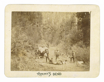
Photograph (Item) - Black and white photograph, Tommy's Bend, c1900
An early black and white photograph taken at Tommy's Bend near Marysville in Victoria.An early black and white photograph taken at Tommy's Bend near Marysville in Victoria. Tommy's Bend is a stretch of road 10 kilometres from Marysville on the Woods Point Road up to Lake Mountain. This road was originally constructed as a corduroy road (or log road) is a type of road or timber trackway made by placing logs, perpendicular to the direction of the road over a low or swampy area. The result is an improvement over impassable mud or dirt roads, yet rough in the best of conditions and a hazard to horses due to shifting loose logs.ARMSTRONG COLLECTION 42 STATION STREET/ SANDRINGHAM 3191/ TEL. (03) 9521 5442/ IAN M.L. ARMSTRONG OAMtommy's bend, marysville, victoria, marysville-wood's point road, corduroy road -
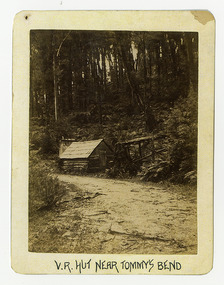
 Marysville & District Historical Society
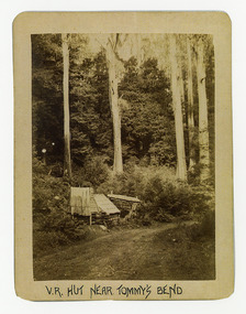
Photograph (Item) - Black and white photograph, V.R. Hut near Tommy's Bend, c1900
An early black and white photograph of a Victoria Roads worker's hut near Tommy's Bend near Marysville in Victoria. An early black and white photograph of a Victoria Roads worker's hut near Tommy's Bend near Marysville in Victoria. Tommy's Bend is a stretch of road 10 kilometres from Marysville on the Woods Point Road up to Lake Mountain.ARMSTRONG COLLECTION 42 STATION STREET/ SANDRINGHAM 3191/ TEL. (03) 9521 5442/ IAN M.L. ARMSTRONG OAMtommy's bend, marysville, victoria, marysville-wood's point road -
 Marysville & District Historical Society
Photograph (Item) - Black and white photograph, Beech Forest Beyond Tommy's Bend, c1900
An early black and white photograph of The Beeches, which is known as the Beech Grove, near Tommy's Bend near Marysville in Victoria.An early black and white photograph of The Beeches, which is known as the Beech Grove, near Tommy's Bend near Marysville in Victoria. Tommy's Bend is a stretch of road 10 kilometres from Marysville on the Wood's Point Road up to Lake Mountain. The Beeches Rainforest Walk is a loop that starts at Taggerty Cascades before winding through Myrtle Beech and Mountain Ash woodland and is one of the many walking tracks in and around Marysville. It is accessible from Lady Talbot Drive which is a 24 kilometer scenic rainforest car journey which passes a number of walks and waterfalls in the Yarra Ranges National Park. Lady Talbot Drive is named after Lady Sarah Elizabeth, the wife of Sir Reginald Talbot, who was the Governor of Victoria from 25th April, 1904 to 6th July 1908.ARMSTRONG COLLECTION 42 STATION STREET/ SANDRINGHAM 3191/ TEL. (03) 9521 5442/ IAN M.L. ARMSTRONG OAMtommy's bend, marysville, victoria, marysville-wood's point road, beech grove, wood's point road, lake mountain, beeches rainforest walk, taggerty cascades, myrtle beech, mountain ash, lady talbot drive, lady talbot forest drive, lady sarah elizabeth talbot, sir reginald talbot -
 Marysville & District Historical Society
Photograph (Item) - Black and white photograph, Bridge Over The Cumberland, c1900
An early black and white photograph of a bridge over the Cumberland Creek near Marysville in Victoria.An early black and white photograph of a bridge over the Cumberland Creek near Marysville in Victoria. The Cumberland Creek is in the Cumberland Valley near Cambarville which was a timber town near Marysville. Cambarville is notable for its giant mountain ash (Eucalyptus regnans) trees within the Cumberland Memorial Scenic Reserve, and relics from former sawmills and gold mining. The Big Culvert is located nearby on the Marysville - Woods Point Road, which was historically part of the Yarra Track. Cambarville was established as a timber mill town in the 1940s. Timber mill owners A Cameron and FJ Barton named Cambarville. They established the mill to salvage timber from trees destroyed in the 1939 bushfires. Cambarville was impacted by the 2009 Black Saturday bushfires and any remaining structures were destroyed.ARMSTRONG COLLECTION 42 STATION STREET/ SANDRINGHAM 3191/ TEL. (03) 9521 5442/ IAN M.L. ARMSTRONG OAMcumberland creek, marysville, victoria, cumberland valley, cambarville, mountain ash, eucalyptus regnans, cumberland memorial reserve, the big culvert, marysville-wood's point road, yarra track, a cameron, fj barton, 2009 black saturday bushfires -
 Marysville & District Historical Society
Photograph (Item) - Black and white photograph, Way to Cumberland Falls, c1900
An early black and white photograph of the forest near the Cumberland Falls in Victoria.An early black and white photograph of the forest near the Cumberland Falls in Victoria. The falls are located on the Marysville-Wood's Point Road. Cambarville is notable for its giant mountain ash (Eucalyptus regnans) trees within the Cumberland Memorial Scenic Reserve, and relics from former sawmills and gold mining. The Big Culvert is located nearby on the Marysville - Woods Point Road, which was historically part of the Yarra Track. Cambarville was established as a timber mill town in the 1940s. Timber mill owners A Cameron and FJ Barton named Cambarville. They established the mill to salvage timber from trees destroyed in the 1939 bushfires. Cambarville was impacted by the 2009 Black Saturday bushfires and any remaining structures were destroyed.ARMSTRONG COLLECTION 42 STATION STREET/ SANDRINGHAM 3191/ TEL. (03) 9521 5442/ IAN M.L. ARMSTRONG OAMcumberland falls, cambarville, marysville, victoria, waterfalls, postcard, souvenir, mountain ash, mining, timber mills, big culvert, yarra track, a cameron, fj barton, black saturday bushfires, 1939 bushfires, eucalyptus regnans -
 Marysville & District Historical Society
Photograph (Item) - Black and white photograph, Cumberland Falls, c1900
An early black and white photograph of Cumberland Falls near Marysville in Victoria.An early black and white photograph of Cumberland Falls near Marysville in Victoria. These falls are located on the Marysville-Wood's Point Road. Cambarville is notable for its giant mountain ash (Eucalyptus regnans) trees within the Cumberland Memorial Scenic Reserve, and relics from former sawmills and gold mining. The Big Culvert is located nearby on the Marysville - Woods Point Road, which was historically part of the Yarra Track. Cambarville was established as a timber mill town in the 1940s. Timber mill owners A Cameron and FJ Barton named Cambarville. They established the mill to salvage timber from trees destroyed in the 1939 bushfires. Cambarville was impacted by the 2009 Black Saturday bushfires and any remaining structures were destroyed.ARMSTRONG COLLECTION 42 STATION STREET/ SANDRINGHAM 3191/ TEL. (03) 9521 5442/ IAN M.L. ARMSTRONG OAMcumberland falls, cambarville, marysville, victoria, waterfalls, postcard, souvenir, mountain ash, mining, timber mills, big culvert, yarra track, a cameron, fj barton, black saturday bushfires, 1939 bushfires, eucalyptus regnans -
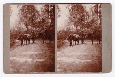 Marysville & District Historical Society
Photograph (Item) - Black and white bi-focal image, Unknown
An early black and white bi-focal image of men and packhorses on the Marysville-Wood's Point Road in Marysville in Victoria.An early black and white bi-focal image of men and packhorses on the Marysville-Wood's Point Road in Marysville in Victoria. This is now known as the Marysville-Wood's Point Road. The Marysville-Woods Point Road was originally part of the Yarra Track, constructed in the early 1860s to provide access between Healesville and the Woods Point Goldfields. Despite the steep terrain and engineering difficulties, the Yarra Track soon became a busy route used by pack horses, horse-drawn drays, and wagons. Today this sealed mountain road is a popular scenic drive between Marysville and Warburton.Packhorses on Wood'spoint Road/ Marysville/ Victoriapackhorses, wood's point road, marysville-wood's point road, marysville, victoria, yarra track, healesville, wood's point goldfields, warburton -
Marysville & District Historical Society
Document (Item) - Newspaper article, The Argus, New Tourist Road. Marysville to Wood's Point Magnificent Forest Scenery, 02-1924
A newspaper article regarding the opening of the Marysville-Wood's Point Road in February 1924.A newspaper article regarding the opening of the Marysville-Wood's Point Road in February 1924. The Marysville-Woods Point Road was originally part of the Yarra Track, constructed in the early 1860s to provide access between Healesville and the Woods Point Goldfields. Despite the steep terrain and engineering difficulties, the Yarra Track soon became a busy route used by pack horses, horse-drawn drays, and wagons. Today this sealed mountain road is a popular scenic drive between Marysville and Warburton.marysville-wood's point road, yarra track, healesville, wood's point goldfields, warburton, the argus -
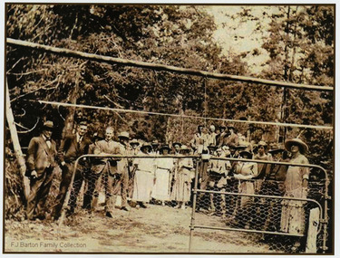 Marysville & District Historical Society
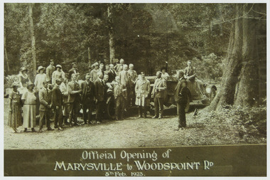
Photograph (Item) - Black and white photograph, 05-02-1924
An early black and white photograph of the ceremonial re-opening of the Marysville-Wood's Point Road in 1924.An early black and white photograph of the ceremonial re-opening of the Marysville-Wood's Point Road in 1924. The Marysville-Woods Point Road was originally part of the Yarra Track, constructed in the early 1860s to provide access between Healesville and the Woods Point Goldfields. Despite the steep terrain and engineering difficulties, the Yarra Track soon became a busy route used by pack horses, horse-drawn drays, and wagons. Today this sealed mountain road is a popular scenic drive between Marysville and Warburton.F.J. Barton Family Collectionmarysville-wood's point road, marysville, wood's point goldfields, healesville, yarra track, warburton -
 Marysville & District Historical Society
Photograph (Item) - Black and white photograph, 05-02-1924
An early black and white photograph of the ceremonial re-opening of the Marysville-Wood's Point Road in 1924.An early black and white photograph of the ceremonial re-opening of the Marysville-Wood's Point Road in 1924. The Marysville-Woods Point Road was originally part of the Yarra Track, constructed in the early 1860s to provide access between Healesville and the Woods Point Goldfields. Despite the steep terrain and engineering difficulties, the Yarra Track soon became a busy route used by pack horses, horse-drawn drays, and wagons. Today this sealed mountain road is a popular scenic drive between Marysville and Warburton.F.J. Barton Family Collectionmarysville-wood's point road, marysville, wood's point goldfields, healesville, yarra track, warburton -
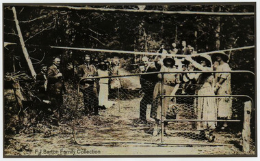
 Marysville & District Historical Society
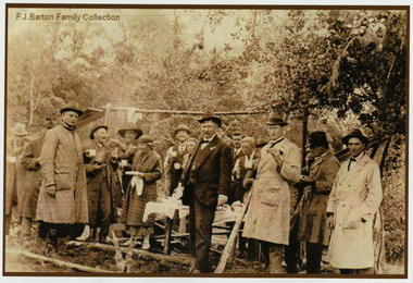
Photograph (Item) - Black and white photograph, Official Opening of MARYSVILLE to WOODSPOINT RD 5th Feb, 1923, 05-02-1924
An early black and white photograph which was taken after the ceremonial re-opening of the Marysville-Wood's Point Road in 1924. The date of 1923 on the photograph is incorrect.An early black and white photograph which was taken after the ceremonial re-opening of the Marysville-Wood's Point Road in 1924. The date of 1923 on the photograph is incorrect. The Marysville-Woods Point Road was originally part of the Yarra Track, constructed in the early 1860s to provide access between Healesville and the Woods Point Goldfields. Despite the steep terrain and engineering difficulties, the Yarra Track soon became a busy route used by pack horses, horse-drawn drays, and wagons. Today this sealed mountain road is a popular scenic drive between Marysville and Warburton.Official Opening of/ MARYSVILLE to WOODSPOINT RD/ 5th Feb, 1923marysville-wood's point road, marysville, wood's point goldfields, healesville, yarra track, warburton, the argus -
Marysville & District Historical Society
Document (Item) - Research Document, Joan Anderson, John W Lindt, Unknown
An account of the life of John W Lindt.An account of the life of John W Lindt. John William Lindt (1845–1926), was a German-born Australian landscape and ethnographic photographer, early photojournalist, and portraitist. John Lindt was responsible for a folio of photographs of the Fernshaw and Watts River area and he sold over 25,000 images of the Black Spur from his original negatives. In 1895 he was able to purchase land on the North East side of the Black Spur and subsequently built his home and guesthouse "The Hermitage" from where he continued his photographic career. In 1913 he collaborated with Nicholas Caire to produce a tourist booklet on the area. In 1925 the Argus reported that Lindt "continues to produce remarkable and most artistic pictures of the beauties of mountain landscape. He is not a believer in the blurred effects favoured by many ... instead he is a master of detail." Aged 81 Lindt died of heart failure during disastrous bushfires on 19 February 1926 at the Hermitage. He was survived by his wife Catherine who continued to run ‘The Hermitage’ guest house before she retired to the city.john william lindt, fernshaw, watts river, black spur, the hermitage, nicholas, nicholas john caire, the argus -
 Marysville & District Historical Society
Photograph (Item) - Black and white photographs, Unknown
Early black and white photographs of John William Lindt.Early black and white photographs of John William Lindt. John William Lindt (1845–1926), was a German-born Australian landscape and ethnographic photographer, early photojournalist, and portraitist. John Lindt was responsible for a folio of photographs of the Fernshaw and Watts River area and he sold over 25,000 images of the Black Spur from his original negatives. In 1895 he was able to purchase land on the North East side of the Black Spur and subsequently built his home and guesthouse "The Hermitage" from where he continued his photographic career. In 1913 he collaborated with Nicholas Caire to produce a tourist booklet on the area. In 1925 the Argus reported that Lindt "continues to produce remarkable and most artistic pictures of the beauties of mountain landscape. He is not a believer in the blurred effects favoured by many ... instead he is a master of detail." Aged 81 Lindt died of heart failure during disastrous bushfires on 19 February 1926 at the Hermitage. He was survived by his wife Catherine who continued to run ‘The Hermitage’ guest house before she retired to the city.john william lindt, fernshaw, watts river, black spur, the hermitage, nicholas, nicholas john caire, the argus -
Marysville & District Historical Society
Document (Item) - Book extract, John (Jack) Cato, John William Lindt F.R.G.S. of Melbourne-The Story of the Camera in Australia, 1955
An account of the life of John Willliam Lindt extracted from the book The Story of the Camera in Australia.An account of the life of John Willliam Lindt extracted from the book The Story of the Camera in Australia. John William Lindt (1845–1926), was a German-born Australian landscape and ethnographic photographer, early photojournalist, and portraitist. John Lindt was responsible for a folio of photographs of the Fernshaw and Watts River area and he sold over 25,000 images of the Black Spur from his original negatives. In 1895 he was able to purchase land on the North East side of the Black Spur and subsequently built his home and guesthouse "The Hermitage" from where he continued his photographic career. In 1913 he collaborated with Nicholas Caire to produce a tourist booklet on the area. In 1925 the Argus reported that Lindt "continues to produce remarkable and most artistic pictures of the beauties of mountain landscape. He is not a believer in the blurred effects favoured by many ... instead he is a master of detail." Aged 81 Lindt died of heart failure during disastrous bushfires on 19 February 1926 at the Hermitage. He was survived by his wife Catherine who continued to run ‘The Hermitage’ guest house before she retired to the city. John (Jack) Cato was a keen photographer from an early age and was the author of The Story of the Camera in Australia which when it was first published in 1955, was the first history of Australian photography and photographs.john william lindt, fernshaw, watts river, black spur, the hermitage, nicholas, nicholas john caire, the argus, john (jack) cato, the story of the camera in australia -
 Marysville & District Historical Society
Photograph (Item) - Black and white photograph, Unknown
An early black and white photograph of "The Hermitage" at Narbethong in Victoria.An early black and white photograph of "The Hermitage" at Narbethong in Victoria. "The Hermitage" was built by photographer John William Lindt as a home and guesthouse in 1894. John Lindt had previously photographed the mountain scenery of the Black Spur and purchased 71 acres and subseqently built his home and guesthouse from where he continued his career. "The Hermitage had a garden designed by John Lindt's friend, Ferdinand von Mueller, who was at one stage the Director of the Melbourne Botanic Gardens. The garden featured New Guinea tree houses from which John Lindt made frequent panoramas of his property and the surrounding forest of towering mountain ash. Aged 81 Lindt died of heart failure during disastrous bushfires on 19 February 1926 at the Hermitage. He was survived by his wife Catherine who continued to run ‘The Hermitage’ guest house before she retired to the city.the hermitage, john william lindt, narbethong, victoria, black spur, ferdinand von mueller, melbourne botanic gardens, new guinea, catherine lindt