Showing 3968 items
matching newsletters
-
 Kew Historical Society Inc
Journal, Kewriosity : December 1984
New look - Kewriosity / p1. Community Notices [Religious notices; Clubs] / p2. Update: Notes from Council - Caring about your community / Cr Robin Saunders [Mayor of Kew] p3. Depot works on schedule / p3. Kew Library on the move / p4. [Kew] Recreation Centre / p4. Carols by candlelight / p5. Occasional Care Centre / p5. Full Day Care Centre / p5. Traffic management / p5. Kew Bowling Club - Women make history / Jack Gervasoni p6. Housing needs in Kew / p6. Youth Page - Welcome [Scouting in Kew] / p7. Merry Christmas and Happy New Year/ p8-9. Things to do in Kew / p10-11. Library news / p11. Red alert for Scouts [2nd Kew Scout Group] / p12. Kew Festival / p12.Kewriosity was a local newsletter combining Kew Council and community news. It was published between November 1983 and June 1994, replacing an earlier Kewriosity [broad] Sheet (1979-84). In producing Kewriosity, Council aimed to provide a range of interesting and informative articles covering its deliberations and decision making, together with items of general interest and importance to the Kew community and information not generally available through daily media outlets.non-fictionNew look - Kewriosity / p1. Community Notices [Religious notices; Clubs] / p2. Update: Notes from Council - Caring about your community / Cr Robin Saunders [Mayor of Kew] p3. Depot works on schedule / p3. Kew Library on the move / p4. [Kew] Recreation Centre / p4. Carols by candlelight / p5. Occasional Care Centre / p5. Full Day Care Centre / p5. Traffic management / p5. Kew Bowling Club - Women make history / Jack Gervasoni p6. Housing needs in Kew / p6. Youth Page - Welcome [Scouting in Kew] / p7. Merry Christmas and Happy New Year/ p8-9. Things to do in Kew / p10-11. Library news / p11. Red alert for Scouts [2nd Kew Scout Group] / p12. Kew Festival / p12. publications -- city of kew (vic.), kewriosity, council newsletters, community newsletters -
Kew Historical Society Inc
Journal, Kewriosity : November 1984
60th issue / p1. "Woodlands Avenue" to accomodate 3YO's [Kew Pre-School Support Group; East Kew Baptist Church] / p1. [Kew] Community Festival extended / p1. Books and games for children / p2. 68th Anniversary Hyde Park Uniting Church / p2. Seniors & Lions / p2. Kew [Daytime] Garden Club / p2. Action Programme [Rheumatism and Arthritis Association of Victoria] / p2. Hyde Park Uniting Church Fellowship / p2. Mayoral Column [Council Budget] / p3. A foster family's experience [Inner East Foster Care] / p4. Volunteer helpers needed / p4. Aspects of alcohol use in the community / p4. Kew Citizens' Band / p4. Youth Pages - Welcome [Kew appoints full time youth worker - Ian Patching; International Youth Year 1985; Youth Resource Centre] / p5. Summer - a time for recreation / p6. [Kew] Recreation Centre update - Report from Consultative Committee / p7. Traffic management / p7. Things to do in Kew / p8. Occasional Care Centre / p9. Library news / p9. Tipping facilities / p9. Senior Citizens' Activity Groups in Kew / p9. Kew/Hawthorn Citizens' Advice Bureau / p10. Kalker Montessori Kindergarten / p10. The Billabong Club / p10. Australian Labor Party / p10. Kew Garden Club and Native Plant Group / p10. Parents of Gays / p10. Kew Community House Annual Report [Glendonald; Elderly; Youth; Unemployed; Single parents; Counselling?; Citizens Advice Bureau; Churches; Mural; Courses & Activities; Drop-in Centre; Volunteers] / Mary Scomazzon p11-12. Kew Community House Youth Group / p12.Kewriosity was a local newsletter combining Kew Council and community news. It was published between November 1983 and June 1994, replacing an earlier Kewriosity [broad] Sheet (1979-84). In producing Kewriosity, Council aimed to provide a range of interesting and informative articles covering its deliberations and decision making, together with items of general interest and importance to the Kew community and information not generally available through daily media outlets.non-fiction60th issue / p1. "Woodlands Avenue" to accomodate 3YO's [Kew Pre-School Support Group; East Kew Baptist Church] / p1. [Kew] Community Festival extended / p1. Books and games for children / p2. 68th Anniversary Hyde Park Uniting Church / p2. Seniors & Lions / p2. Kew [Daytime] Garden Club / p2. Action Programme [Rheumatism and Arthritis Association of Victoria] / p2. Hyde Park Uniting Church Fellowship / p2. Mayoral Column [Council Budget] / p3. A foster family's experience [Inner East Foster Care] / p4. Volunteer helpers needed / p4. Aspects of alcohol use in the community / p4. Kew Citizens' Band / p4. Youth Pages - Welcome [Kew appoints full time youth worker - Ian Patching; International Youth Year 1985; Youth Resource Centre] / p5. Summer - a time for recreation / p6. [Kew] Recreation Centre update - Report from Consultative Committee / p7. Traffic management / p7. Things to do in Kew / p8. Occasional Care Centre / p9. Library news / p9. Tipping facilities / p9. Senior Citizens' Activity Groups in Kew / p9. Kew/Hawthorn Citizens' Advice Bureau / p10. Kalker Montessori Kindergarten / p10. The Billabong Club / p10. Australian Labor Party / p10. Kew Garden Club and Native Plant Group / p10. Parents of Gays / p10. Kew Community House Annual Report [Glendonald; Elderly; Youth; Unemployed; Single parents; Counselling?; Citizens Advice Bureau; Churches; Mural; Courses & Activities; Drop-in Centre; Volunteers] / Mary Scomazzon p11-12. Kew Community House Youth Group / p12. publications -- city of kew (vic.), kewriosity, council newsletters, community newsletters -
Kew Historical Society Inc
Journal, Kewriosity : October 1984
[Kew] Recreation Centre update [The Committee; Resident Attitude Survey] / p1. [Anglican] Archbishop's first visit to East Kew [St Paul's Church] / p1. Community [Asian Evangelical Fellowship; Hyde Park Fellowship; Kew Baptist Church; Kew Native Plant Group; Kew Garden Club; Kew (Daytime) Garden Club; Fashion Parade; The Rheumatism and Arthritis Foundation of Victoria; Retiring?; Anyone for tennis?; Games evening] / p2. Council - Mayoral Column / Cr Robin Saunders / p3. New Depot / p3. Library News / p3. Calling on people with disabilities in Kew / p3. Dieback in Kew's Plane Trees / p3. Kew's new Councillors - Roger Streeton; Chester Keon-Cohen] / p4. Kew Junction Shopping Centre - Liftout Guide / p5-6, 11-12. Youth Pages - Welcome / p7. Earth Club Camps / Phil Smith p7. Training the oldies / Elizabeth Trapani p7. Holiday fun around Kew / p8&9. Things to do in Kew / p10. A bit further afield / p10. Community - Artisst take dance , drama & art to the streets / p13. Asthma Foundation / p13. Council - More thoughts about the Community House / p14. 1985 Kew Festival / p14. Development Plan for Lower Yarra / p15. Jackie Kookaburra goes to Sea / p15. Migrant woman candidate for Kew [Anna-Maria Dierer, ALP] / p15. Council/Community - Traffic Management; New Residents' Kit; Family Fun Day [East Kew Uniting Church]; Older Person's Action Centre; Kew Citizens' Band - Engagement list / p16.Kewriosity was a local newsletter combining Kew Council and community news. It was published between November 1983 and June 1994, replacing an earlier Kewriosity [broad] Sheet (1979-84). In producing Kewriosity, Council aimed to provide a range of interesting and informative articles covering its deliberations and decision making, together with items of general interest and importance to the Kew community and information not generally available through daily media outlets.non-fiction[Kew] Recreation Centre update [The Committee; Resident Attitude Survey] / p1. [Anglican] Archbishop's first visit to East Kew [St Paul's Church] / p1. Community [Asian Evangelical Fellowship; Hyde Park Fellowship; Kew Baptist Church; Kew Native Plant Group; Kew Garden Club; Kew (Daytime) Garden Club; Fashion Parade; The Rheumatism and Arthritis Foundation of Victoria; Retiring?; Anyone for tennis?; Games evening] / p2. Council - Mayoral Column / Cr Robin Saunders / p3. New Depot / p3. Library News / p3. Calling on people with disabilities in Kew / p3. Dieback in Kew's Plane Trees / p3. Kew's new Councillors - Roger Streeton; Chester Keon-Cohen] / p4. Kew Junction Shopping Centre - Liftout Guide / p5-6, 11-12. Youth Pages - Welcome / p7. Earth Club Camps / Phil Smith p7. Training the oldies / Elizabeth Trapani p7. Holiday fun around Kew / p8&9. Things to do in Kew / p10. A bit further afield / p10. Community - Artisst take dance , drama & art to the streets / p13. Asthma Foundation / p13. Council - More thoughts about the Community House / p14. 1985 Kew Festival / p14. Development Plan for Lower Yarra / p15. Jackie Kookaburra goes to Sea / p15. Migrant woman candidate for Kew [Anna-Maria Dierer, ALP] / p15. Council/Community - Traffic Management; New Residents' Kit; Family Fun Day [East Kew Uniting Church]; Older Person's Action Centre; Kew Citizens' Band - Engagement list / p16. publications -- city of kew (vic.), kewriosity, council newsletters, community newsletters -
Kew Historical Society Inc
Journal, Kewriosity : September 1984
Mayoral Column / Cr Robin Saunders p1. Local Area Traffic Management / p1. Community News / p2. Kew's new mayor [Cr Robin Saunders] / p3. Retiring Councillors [Cr Martin Solomons; Cr Joe Leaman] / p3. 1985 Kew Community Festival / p3. Library News / p3. 'Germs' - a musical [East Kew Primary School] / p4. "Kiss Me Kate" comes to Kew [Starlight Theatrical Company] / p4. Hyde Park Fellowship / p4. Dance / p4. Missionary Sisters of St Peter Claver / p4. What is the Rotary Club of Kew doing? / p4. WORCO [Worco Recyclotron Project] / p4. Youth pages - Welcome; Teen Club; St Hilary's Earth Club / p5. So you need help with housing? / p6&11. Community [Classes for older adults; Baby sitting clubs; Kew Historical Society; Children's Services; Probus Club of Kew] / p7. Municipal Depot update / p8. Council wants E6 and park / p8. Have you enrolled your child for kindergarten yet? / p9. Kew Toy Library / p10. Full Day Care Centre / p10. Things to do in Kew / p11. A bit further afield / p11. [Multilingual information about incinerator use] / p13. [Kew] Community House / p13-15. Disability access in Kew / p15. Heidelberg Tip / p16. New Residents Kit / p16. Kew Swimming Club / p16. Little Athletics / p16. Child restraints / p16.Kewriosity was a local newsletter combining Kew Council and community news. It was published between November 1983 and June 1994, replacing an earlier Kewriosity [broad] Sheet (1979-84). In producing Kewriosity, Council aimed to provide a range of interesting and informative articles covering its deliberations and decision making, together with items of general interest and importance to the Kew community and information not generally available through daily media outlets.non-fictionMayoral Column / Cr Robin Saunders p1. Local Area Traffic Management / p1. Community News / p2. Kew's new mayor [Cr Robin Saunders] / p3. Retiring Councillors [Cr Martin Solomons; Cr Joe Leaman] / p3. 1985 Kew Community Festival / p3. Library News / p3. 'Germs' - a musical [East Kew Primary School] / p4. "Kiss Me Kate" comes to Kew [Starlight Theatrical Company] / p4. Hyde Park Fellowship / p4. Dance / p4. Missionary Sisters of St Peter Claver / p4. What is the Rotary Club of Kew doing? / p4. WORCO [Worco Recyclotron Project] / p4. Youth pages - Welcome; Teen Club; St Hilary's Earth Club / p5. So you need help with housing? / p6&11. Community [Classes for older adults; Baby sitting clubs; Kew Historical Society; Children's Services; Probus Club of Kew] / p7. Municipal Depot update / p8. Council wants E6 and park / p8. Have you enrolled your child for kindergarten yet? / p9. Kew Toy Library / p10. Full Day Care Centre / p10. Things to do in Kew / p11. A bit further afield / p11. [Multilingual information about incinerator use] / p13. [Kew] Community House / p13-15. Disability access in Kew / p15. Heidelberg Tip / p16. New Residents Kit / p16. Kew Swimming Club / p16. Little Athletics / p16. Child restraints / p16. publications -- city of kew (vic.), kewriosity, council newsletters, community newsletters -
Kew Historical Society Inc
Journal, Kewriosity : August 1984
Community key to festival success / p1. Kew Citizens' Band returns / p1&2. Community [Hyde Park Fellowship; Kew Baptist Church; Asian Evangelical Partnership; Kew City Bowmen; Kew Garden Club; Native Plant Group; Kew (Daytime} Garden Club; RAAV Action Programme; Australian Labor Party; "indoor Recreation Centre"; Neighbourhood Watch established in Kew; Sacred Heart Caring Group; Kew Historical Society; Victoria's 150th: opening of 150 private gardens; Kew Amateur Swimming Club; Kew Bowling Club; Childminding ] / p2, 14, 16. Mayor's Column / Cr Jill O'Brien [Mayor of Kew] / p3. Traffic Management / p3. "The Gatehouse' [Dementia; Willsmere; Mental health] / p4. Youth Pages [Youth After-School Programme; Youth Holiday programme] / p5. [Youth] Unemployment??? / p6&11. Kew Junction Shopping Centre - Lift-out guide / p7-10. Things to do in Kew; A bit further afield ... / p11. Survival English [Literacy] / p12. Liability [Occupiers' Liability Act] / p12. Municipal elections / p12. Council - Commonly asked questions - and answers / p15. Kewriosity editorial guidelines /p16.Kewriosity was a local newsletter combining Kew Council and community news. It was published between November 1983 and June 1994, replacing an earlier Kewriosity [broad] Sheet (1979-84). In producing Kewriosity, Council aimed to provide a range of interesting and informative articles covering its deliberations and decision making, together with items of general interest and importance to the Kew community and information not generally available through daily media outlets.non-fictionCommunity key to festival success / p1. Kew Citizens' Band returns / p1&2. Community [Hyde Park Fellowship; Kew Baptist Church; Asian Evangelical Partnership; Kew City Bowmen; Kew Garden Club; Native Plant Group; Kew (Daytime} Garden Club; RAAV Action Programme; Australian Labor Party; "indoor Recreation Centre"; Neighbourhood Watch established in Kew; Sacred Heart Caring Group; Kew Historical Society; Victoria's 150th: opening of 150 private gardens; Kew Amateur Swimming Club; Kew Bowling Club; Childminding ] / p2, 14, 16. Mayor's Column / Cr Jill O'Brien [Mayor of Kew] / p3. Traffic Management / p3. "The Gatehouse' [Dementia; Willsmere; Mental health] / p4. Youth Pages [Youth After-School Programme; Youth Holiday programme] / p5. [Youth] Unemployment??? / p6&11. Kew Junction Shopping Centre - Lift-out guide / p7-10. Things to do in Kew; A bit further afield ... / p11. Survival English [Literacy] / p12. Liability [Occupiers' Liability Act] / p12. Municipal elections / p12. Council - Commonly asked questions - and answers / p15. Kewriosity editorial guidelines /p16. publications -- city of kew (vic.), kewriosity, council newsletters, community newsletters -
Kew Historical Society Inc
Journal, Kewriosity : July 1984
Street trees in Kew [Carol Frank-Mas & Associates, Landscape Architects Report] / p1. Community [Gamblers Annymousl Action Programme; Save the Children Fund; Kew Garden Club; Native Plant Group; Kew Baptist Church; Hyde Park Fellowship; Film afternoon; Toy Library; Kew Junction Traders - advertising] / p2. Raoul Wallenberg Gardens / p3. Kew Recreation Centre / p3. Kew Historical Society / p3. Kew Community House / p4. Youth Pages [New Youth Centre for Kew; Unemployed? / p5. International Youth Year 1985 [What is it? So..., In Kew! Plans] / p6-7. [Youth] Talkback / p7. Things to do in Kew [&] A bit further afield [Kew Drop-in; After school activities; The Gap; Teen Club; Community House] / p8. Mayoral Comment - "Villa Alba" / Cr Jill O'Brien [Mayor of Kew] / p9. Community Directory updates / p9. Sahara Yoga [Centre] / p10. Community artists / p10. Highbury Grove Playgroup / p10. Kew Senior Citizens' Centre / p10. Powerlines and street trees / p11. Kindergarten enrolments / p11. Immunisation sessions / p11. Roadworks / p11. Drivers needed [Kew Community Bus] / p11. Domestic noise / p11. C.A.B. [Citizens' Advice Bureau] / p11. Kew (Daytime) Garden Club / p11. Kew people for nuclear disarmament / p11. H.K.C. Activities Centre / p11. Children's Services in Kew [Occasional Care Centre; Children's Services Officer; Full-Time Day Care Centre; Three Year Old Kindergarten; After School Programme; Extended Hours Kindergarten] / p12.Kewriosity was a local newsletter combining Kew Council and community news. It was published between November 1983 and June 1994, replacing an earlier Kewriosity [broad] Sheet (1979-84). In producing Kewriosity, Council aimed to provide a range of interesting and informative articles covering its deliberations and decision making, together with items of general interest and importance to the Kew community and information not generally available through daily media outlets.non-fictionStreet trees in Kew [Carol Frank-Mas & Associates, Landscape Architects Report] / p1. Community [Gamblers Annymousl Action Programme; Save the Children Fund; Kew Garden Club; Native Plant Group; Kew Baptist Church; Hyde Park Fellowship; Film afternoon; Toy Library; Kew Junction Traders - advertising] / p2. Raoul Wallenberg Gardens / p3. Kew Recreation Centre / p3. Kew Historical Society / p3. Kew Community House / p4. Youth Pages [New Youth Centre for Kew; Unemployed? / p5. International Youth Year 1985 [What is it? So..., In Kew! Plans] / p6-7. [Youth] Talkback / p7. Things to do in Kew [&] A bit further afield [Kew Drop-in; After school activities; The Gap; Teen Club; Community House] / p8. Mayoral Comment - "Villa Alba" / Cr Jill O'Brien [Mayor of Kew] / p9. Community Directory updates / p9. Sahara Yoga [Centre] / p10. Community artists / p10. Highbury Grove Playgroup / p10. Kew Senior Citizens' Centre / p10. Powerlines and street trees / p11. Kindergarten enrolments / p11. Immunisation sessions / p11. Roadworks / p11. Drivers needed [Kew Community Bus] / p11. Domestic noise / p11. C.A.B. [Citizens' Advice Bureau] / p11. Kew (Daytime) Garden Club / p11. Kew people for nuclear disarmament / p11. H.K.C. Activities Centre / p11. Children's Services in Kew [Occasional Care Centre; Children's Services Officer; Full-Time Day Care Centre; Three Year Old Kindergarten; After School Programme; Extended Hours Kindergarten] / p12. publications -- city of kew (vic.), kewriosity, council newsletters, community newsletters -
Kew Historical Society Inc
Journal, Kewriosity : June 1984
Mayoral Comment - Swedish hero honoured in Kew [Raoul Wallenberg] / Cr Jill O'Brien p1. The village without a name [Edgevale Road] / Barbara Giles p1. Billabong Club / p2. Wine bottling / p2. Sunday afternoon at Kew / p2. Kew Garden Club / p2. Native Plant Group / p2. Asian Evangelical Fellowship / p2. Early Planning for retirement / p2. The Rheumatism and Arthritis Association of Victoria / p2. Kew (Daytime) Garden Club / p2. Hyde Park Fellowship / p2. Penguin Club / p2. F.A.C.S. [Family and Community Services Programme / p3. New Residents Kits / p3. Parking permits for people with physical disabilities / p3. Occupational Therapist in Kew / p4. Physiotherapists / p4. Speech pathology / p4. Children's Services / p4. Area 10 Traffic Management / p5. Kew Historical Society happenings / p5. Community artists / p5. New Victoria building regulations / p6. Voting / p6. Safety [footpaths] / p6. Domestic noise / p6. Volunteers ["Gatehouse"]/ p7. Foster Care information [Inner East Foster Care] / p7. Kew Residents Group / p7. Black sheep and family crests [Kew Library, Genealogy] / p7. Infantile Paralysis [Poliomyelitis] / p7. Kew Community House News / Rhonda McCaw p8. Art Show / p8. Immunisation Sessions / p8. Parks and gardens / p8.Kewriosity was a local newsletter combining Kew Council and community news. It was published between November 1983 and June 1994, replacing an earlier Kewriosity [broad] Sheet (1979-84). In producing Kewriosity, Council aimed to provide a range of interesting and informative articles covering its deliberations and decision making, together with items of general interest and importance to the Kew community and information not generally available through daily media outlets.non-fictionMayoral Comment - Swedish hero honoured in Kew [Raoul Wallenberg] / Cr Jill O'Brien p1. The village without a name [Edgevale Road] / Barbara Giles p1. Billabong Club / p2. Wine bottling / p2. Sunday afternoon at Kew / p2. Kew Garden Club / p2. Native Plant Group / p2. Asian Evangelical Fellowship / p2. Early Planning for retirement / p2. The Rheumatism and Arthritis Association of Victoria / p2. Kew (Daytime) Garden Club / p2. Hyde Park Fellowship / p2. Penguin Club / p2. F.A.C.S. [Family and Community Services Programme / p3. New Residents Kits / p3. Parking permits for people with physical disabilities / p3. Occupational Therapist in Kew / p4. Physiotherapists / p4. Speech pathology / p4. Children's Services / p4. Area 10 Traffic Management / p5. Kew Historical Society happenings / p5. Community artists / p5. New Victoria building regulations / p6. Voting / p6. Safety [footpaths] / p6. Domestic noise / p6. Volunteers ["Gatehouse"]/ p7. Foster Care information [Inner East Foster Care] / p7. Kew Residents Group / p7. Black sheep and family crests [Kew Library, Genealogy] / p7. Infantile Paralysis [Poliomyelitis] / p7. Kew Community House News / Rhonda McCaw p8. Art Show / p8. Immunisation Sessions / p8. Parks and gardens / p8. publications -- city of kew (vic.), kewriosity, council newsletters, community newsletters -
Kew Historical Society Inc
Journal, Kewriosity : May 1984
Bringing back the memories - in style [William Martin, Elder Care] / p1. Petrie Square / p1. Billabong Club / p2. Kew Garden Club / p2. Gone Bush! [Native Plant Group] / p2. Kew Bowling Club / p2. The Rheumatism and Arthritis Association Kew Self Help Group / p2. National Arthritis Week in Victoria / p2. Kew (Daytime) Garden Club / p2. Hockey [Kew Women's Hockey Club] / p2. Scouts / p2. May School Holiday Programme [Mobile New Trailer Games; Drop-in Centre; Kew Traffic School; Building or renovating; / p3. Kew Youth Resource Centre / p3. How Green is Our Valley - a continuing saga [S.E.C. Yarra Valley Powerlines] / p4. Mayoral Comment - Kew, its park and the SEC / Cr Jill O'Brien p5. Kew heritage [proposed heritage study] / p5. Philharmonic [Kew Philharmonic Orchestra] / p6. Kew Holiday Programme [Sacred Heart Church] / p6. The Gibbs Wathen Family re-union / p6. Yarra River Study - Dights' Falls to Burke Road / p6. Starlight Theatrical Company / p6. Kew Community House - 2nd Term Programme / p7. Public meeting - information sharing in Kew [Kewriosity Editorial Committee] / p7. Recyclotron / p7. Public Meeting - SEC Power Line / p8. Datelines [KPSA auction of pre-loved goods; A.L.P.; Guide Dogs Toastmasters Club, Kew - 100th meeting] / p8. Building? [regulations] / p8.Kewriosity was a local newsletter combining Kew Council and community news. It was published between November 1983 and June 1994, replacing an earlier Kewriosity [broad] Sheet (1979-84). In producing Kewriosity, Council aimed to provide a range of interesting and informative articles covering its deliberations and decision making, together with items of general interest and importance to the Kew community and information not generally available through daily media outlets.non-fictionBringing back the memories - in style [William Martin, Elder Care] / p1. Petrie Square / p1. Billabong Club / p2. Kew Garden Club / p2. Gone Bush! [Native Plant Group] / p2. Kew Bowling Club / p2. The Rheumatism and Arthritis Association Kew Self Help Group / p2. National Arthritis Week in Victoria / p2. Kew (Daytime) Garden Club / p2. Hockey [Kew Women's Hockey Club] / p2. Scouts / p2. May School Holiday Programme [Mobile New Trailer Games; Drop-in Centre; Kew Traffic School; Building or renovating; / p3. Kew Youth Resource Centre / p3. How Green is Our Valley - a continuing saga [S.E.C. Yarra Valley Powerlines] / p4. Mayoral Comment - Kew, its park and the SEC / Cr Jill O'Brien p5. Kew heritage [proposed heritage study] / p5. Philharmonic [Kew Philharmonic Orchestra] / p6. Kew Holiday Programme [Sacred Heart Church] / p6. The Gibbs Wathen Family re-union / p6. Yarra River Study - Dights' Falls to Burke Road / p6. Starlight Theatrical Company / p6. Kew Community House - 2nd Term Programme / p7. Public meeting - information sharing in Kew [Kewriosity Editorial Committee] / p7. Recyclotron / p7. Public Meeting - SEC Power Line / p8. Datelines [KPSA auction of pre-loved goods; A.L.P.; Guide Dogs Toastmasters Club, Kew - 100th meeting] / p8. Building? [regulations] / p8. publications -- city of kew (vic.), kewriosity, council newsletters, community newsletters -
Kew Historical Society Inc
Journal, Kewriosity : April 1984
Information sharing in Kew - Public Meeting (Kewriosity Editorial Committee] / p1. Hay's Paddock - something for everyone / p1. Kew Citizens' Band Concert Tour / p2. 3MBS-FM: Kew's own radio station / p2. Community artists / p2. Public meeting [Shrublands, Children with disabilities] / p2. Financial counselling [Care Force, Citizens' Advice Bureau] / p3. Kew Recreation Centre / p3. Children's Services / p3. Fires and incinerators / p4. New Building Regulations / p3. Eggshell spectacular [Kew Library] / p3. Kew East Primary School [history] / G.F. Lindsay p4. Heritage Week - Historical Photograph Collection / p5. Renaissance dancing / p5. K.G.C. leaves no stone unturned [Kew Garden Club] / p5. Native Plant Group / p5. Exercise the rhythmic way / p5. Kew Young Liberals / p5. Rheumatism and arthritis / p5. Traffic management / p6. Drivers and jockeys wanted [Meals on Wheels] / p6. Delivering Kewriosity / p6. Hyde Park Fellowship / p6. Rate payments / p6. Information officer / p6. Trash and treasure [Carnsworth Garoopna] / p6. Youth Resource Centre / p7. Kew City Bowmen / p7. Scrabble [The Scrabble Club] / p7. Billabong Club / p7. Kew (Daytime) Garden Club / p7. Mayoral Comment - Media Merger; Role of Council / Cr Jill O'Brien, Mayor [of Kew] / p8. Coming events / p8.Kewriosity was a local newsletter combining Kew Council and community news. It was published between November 1983 and June 1994, replacing an earlier Kewriosity [broad] Sheet (1979-84). In producing Kewriosity, Council aimed to provide a range of interesting and informative articles covering its deliberations and decision making, together with items of general interest and importance to the Kew community and information not generally available through daily media outlets.non-fictionInformation sharing in Kew - Public Meeting (Kewriosity Editorial Committee] / p1. Hay's Paddock - something for everyone / p1. Kew Citizens' Band Concert Tour / p2. 3MBS-FM: Kew's own radio station / p2. Community artists / p2. Public meeting [Shrublands, Children with disabilities] / p2. Financial counselling [Care Force, Citizens' Advice Bureau] / p3. Kew Recreation Centre / p3. Children's Services / p3. Fires and incinerators / p4. New Building Regulations / p3. Eggshell spectacular [Kew Library] / p3. Kew East Primary School [history] / G.F. Lindsay p4. Heritage Week - Historical Photograph Collection / p5. Renaissance dancing / p5. K.G.C. leaves no stone unturned [Kew Garden Club] / p5. Native Plant Group / p5. Exercise the rhythmic way / p5. Kew Young Liberals / p5. Rheumatism and arthritis / p5. Traffic management / p6. Drivers and jockeys wanted [Meals on Wheels] / p6. Delivering Kewriosity / p6. Hyde Park Fellowship / p6. Rate payments / p6. Information officer / p6. Trash and treasure [Carnsworth Garoopna] / p6. Youth Resource Centre / p7. Kew City Bowmen / p7. Scrabble [The Scrabble Club] / p7. Billabong Club / p7. Kew (Daytime) Garden Club / p7. Mayoral Comment - Media Merger; Role of Council / Cr Jill O'Brien, Mayor [of Kew] / p8. Coming events / p8. publications -- city of kew (vic.), kewriosity, council newsletters, community newsletters -
Kew Historical Society Inc
Journal, Kewriosity : March 1984
Kew Festival 1984 / p1. Kew Festival programme / p2-5. Kew Community House [Background; What is a Community House?; the Co-ordinator; the Community House and the Kew Festival] / p6. Skin Diving [Kew Skin Diving Club] / p6. That's life / p6. Could you open your home to a child? [Inner East Foster Care] / p7. Book Fair / p7. Mayoral Comment - New Municipal Depot / p8. Coming events / p8.Kewriosity was a local newsletter combining Kew Council and community news. It was published between November 1983 and June 1994, replacing an earlier Kewriosity [broad] Sheet (1979-84). In producing Kewriosity, Council aimed to provide a range of interesting and informative articles covering its deliberations and decision making, together with items of general interest and importance to the Kew community and information not generally available through daily media outlets.non-fictionKew Festival 1984 / p1. Kew Festival programme / p2-5. Kew Community House [Background; What is a Community House?; the Co-ordinator; the Community House and the Kew Festival] / p6. Skin Diving [Kew Skin Diving Club] / p6. That's life / p6. Could you open your home to a child? [Inner East Foster Care] / p7. Book Fair / p7. Mayoral Comment - New Municipal Depot / p8. Coming events / p8. publications -- city of kew (vic.), kewriosity, council newsletters, community newsletters -
Kew Historical Society Inc
Journal, Kewriosity : December 1983
Action taken on security of children [Safety House Programme] / p1. Youth venue needed / p1. Extraordinary election - Central Ward / p1. Poodle guides [Guide dogs] / p2. New Welfare Officer [Jennene Arnel] / p2. Uniting Church Normanby Road 'Play Group' or Pre Kinder Support Group / p2. The Rotary Club of Kew / p3. Probus Club [of Kew] / p3. Holiday Programme Activities / p4. Where and what is "Bodalla"? [aged care] / p4. Lisa's school day [Glendonald] / p5. Give a piece of our past this Christmas [Illustrations, Kew Historical Society] / p5. Know your local school [Kew High School] / p6. Coming events / p7. Carols by Candlelight / p8.Kewriosity was a local newsletter combining Kew Council and community news. It was published between November 1983 and June 1994, replacing an earlier Kewriosity [broad] Sheet (1979-84). In producing Kewriosity, Council aimed to provide a range of interesting and informative articles covering its deliberations and decision making, together with items of general interest and importance to the Kew community and information not generally available through daily media outlets.non-fictionAction taken on security of children [Safety House Programme] / p1. Youth venue needed / p1. Extraordinary election - Central Ward / p1. Poodle guides [Guide dogs] / p2. New Welfare Officer [Jennene Arnel] / p2. Uniting Church Normanby Road 'Play Group' or Pre Kinder Support Group / p2. The Rotary Club of Kew / p3. Probus Club [of Kew] / p3. Holiday Programme Activities / p4. Where and what is "Bodalla"? [aged care] / p4. Lisa's school day [Glendonald] / p5. Give a piece of our past this Christmas [Illustrations, Kew Historical Society] / p5. Know your local school [Kew High School] / p6. Coming events / p7. Carols by Candlelight / p8. publications -- city of kew (vic.), kewriosity, council newsletters, community newsletters -
Kew Historical Society Inc
Journal, Kewriosity : November 1983
High Street/Cotham Road intersection / p1. Traffic Management Study - Area 6 / p1. Kew Council elections / p1. Not an elephant joke [community newspapers] / p2. Kew–Hathorn C.A.B. [Citizens' Advice Bureau] / p3. Family trees [Genealogy] / p3. Little Aths / p3. Kew Hebrew Congregation / p3. Asthma Education / p4. A place of shades [Boroondara General (Kew) Cemetery] / Barbara Giles p4. More than a school [Villa Maria Society; St Paul's School for the Blind and Visually Handicapped] / p5. Who is she? [Community Education Officer - Nancy Nankervis] / p6. Toastmasters - who are they? / p6. Art classes [Donald Cameron] / p6. Fundraising [St Paul's Church Hall] / p6. Kew Cricket underway [Kew Cricket Club] / p7. Kew Baptist Church / p7. Coming events / p8.Kewriosity was a local newsletter combining Kew Council and community news. It was published between November 1983 and June 1994, replacing an earlier Kewriosity [broad] Sheet (1979-84). In producing Kewriosity, Council aimed to provide a range of interesting and informative articles covering its deliberations and decision making, together with items of general interest and importance to the Kew community and information not generally available through daily media outlets.non-fictionHigh Street/Cotham Road intersection / p1. Traffic Management Study - Area 6 / p1. Kew Council elections / p1. Not an elephant joke [community newspapers] / p2. Kew–Hathorn C.A.B. [Citizens' Advice Bureau] / p3. Family trees [Genealogy] / p3. Little Aths / p3. Kew Hebrew Congregation / p3. Asthma Education / p4. A place of shades [Boroondara General (Kew) Cemetery] / Barbara Giles p4. More than a school [Villa Maria Society; St Paul's School for the Blind and Visually Handicapped] / p5. Who is she? [Community Education Officer - Nancy Nankervis] / p6. Toastmasters - who are they? / p6. Art classes [Donald Cameron] / p6. Fundraising [St Paul's Church Hall] / p6. Kew Cricket underway [Kew Cricket Club] / p7. Kew Baptist Church / p7. Coming events / p8. publications -- city of kew (vic.), kewriosity, council newsletters, community newsletters -
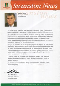 Melbourne Tram Museum
Magazine, Swanston Trams, "Swanston News", Oct. 1997
Newsletter -single A4 sheet printed on gloss paper - "Swanston News" - issue No. 1, undated published at the time of the formation of Swanston Trams. Welcome message from Russell Nathan, Managing Director and noting the need for change. See also Reg Item 385 for another version. Swanston trams formed Oct. 1997 (see https://en.wikipedia.org/wiki/M-Tram - accessed 17/3/2018)trams, tramways, swanston trams -
 Melbourne Tram Museum
Newsletter, North Fitzroy Depot, "North Fitzroy Depot Bulletin", 1980 - 1981
Set of two duplicated newsletters printed on coloured foolscap duplicated paper, "North Fitzroy Depot Bulletin" .1 - 25-11-1980 - moves against conductor's jobs, public transport, medical issues, one man operations, Lonie report, prepaid tickets, rosters and running times. .2 - 5-1-1981 - conductors, buses, rosters, Clifton Hill, Bourke St trams, uniforms, awards.Handwritten note / letter from Chris Jacobson.trams, tramways, conductors, medical, tickets, one man trams, bourke st, uniforms -
 Melbourne Tram Museum
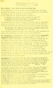
Newsletter, Yarra Trams, "Gold Medal Moments - April 2006", Apr. 2006
Newsletter - two fold A4, full colour titled "Gold Medal Moments - April 2006", featuring a Golding cartoon on the front cover, about the 2006 Melbourne Commonwealth Games. Has many comments from passengers, including of Z81, Karachi tram and many photos. Included in the item is a letter from the Premier of Victoria, Steve Bracks and Minister for Transport, congratulating Yarra trams and staff for the event.trams, tramways, yarra trams, commonwealth games, karachi, passengers, cartoons, tram 81 -
 Melbourne Tram Museum
Magazine, Glen Eira Historical Society, "Glen Eira Historical Society Newsletter", Sep. 2014
Parts OF the Glen Eira Historical Society Newsletter" for September 2014 with items on the McKinnon Road shopping centre, a report on a talk by Ian Jenkin of the ARHS Vic Div about the Caulfield horse tramway and the PMTT and a report of a walk along the horse tram route conducted by Peter Carwardine of the ARHS in July 2014. Includes a donation note from Member Keith Stodden, dated 25-9-2014trams, tramways, caulfield, horse trams, glen eira, mckinnon rd -
Glen Eira Historical Society
Document - St David’s Uniting Church, Glen Huntly
Brief history on St David’s Presbyterian Church, 144 Grange Road, Glen Huntly, mentioning that the church first began at Mr. A W F. Smith's home, on the corner of Grange and Glen Huntly Road. St David’s Uniting Church, March and April, 1984 newsletters; Newspaper article on forthcoming auction of 140 Grange Road, dated 29/03/2004st david’s uniting church, pollard rev., flynn john dr., grange road, wallace rev., muirhead j, glen huntly, boyd rev, smith a.w. f., clau j rev., love rev., foundation stones, millar rev., vertigan s.a rev., moorhead kenneth rev, sunday schools, grange road, manses, moorhead joan, piper pat, glen huntly, james street, wright l mrs, piper geoff, fenton leo, lambe j, barnes p, allen beryl, nicholls betty, courtnay sam, mccowan r, allen percy -
Glen Eira Historical Society
Letter - Cromarty School For Girls
Two articles on Cromarty Jubilee. An Article taken from the Caulfield Historical Society Newsletter Vol.11 December 1972 regarding the history and Jubilee year and launch of a short school history. Correspondence from Doris McKellar on the success of the annual At Home, at Dorothy Jacobs dated 23/11/1972. Includes brief history of school and mention of some past students.cromarty school for girls, day misses, orrong road south, sandham street, cromarty old girls association, clubs and associations, jacob dorothy, stephenson miss, teachers, milne barbara, elsternwick, mckellar doris, archer margaret lee -
 Eltham District Historical Society Inc
Work on paper (item) - Photograph, 2 Metery Road, Eltham South
Robert and Ada Zull built an Alistair Knox designed house at 2 (lot 8) Metery Road, Eltham, a one acre property for their family of five in the mid 1960s. Susan Bennett, nee Zull's reminiscences are published in EDHS Newsletter, February and April 2020. "..My father bought second hand bricks and began to pave them over the quagmire outside..."This series of photographs together with the account of personal remiscences provide a unique document of the construction of an Alistair Knox designed home. Knox was a pioneer in the use of mudbricks and recycled materials and is significant to his contribution of this style of architecture in Eltham and the wider Shire of Nillumbik.zull family, eltham south, 2 metery road, alistair knox, bush block, construction, vw beetle -
 Vision Australia
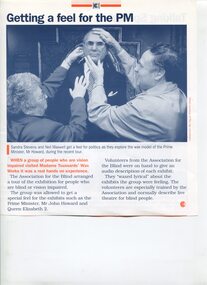
Document - Text, Getting a feel for the PM
Collection of articles featuring an image of Neil Maxwell feeling the waxen head of Prime Minister John Howard, during a visit to Madame Tussaud's exhibition. In some images, he is accompanied by Sandra Stevens, who is also feeling the head. One article is from an Association for the Blind newsletter, two pieces from the Age newspaper, and the rear page of an Association for the Blind publication.Collection of images and articles showing Neil Maxwell with the wax figure of PM John Howardnon-fictionelizabeth maxwell, neil maxwell, sandra stevens, madame tussaud's -
![Australian Nursing Federation 'Proud to be a nurse' badge, [2006?]](/media/collectors/5bb42dc221eaf31100db1d3b/items/5c523b8f21ea6710d8cc88fb/item-media/5c523b9f21ea6710d8cc9ca1/item-fit-380x285.jpg) Australian Nursing & Midwifery Federation
Australian Nursing & Midwifery FederationAustralian Nursing Federation 'Proud to be a nurse' badge, [2006?]
Button distributed to and worn by Australian Nursing Federation (ANF) members. The ANF has been campaigning for greater professional recognition of nurses since its inception as the Victorian Trained Nurses’ Association in 1901. The front cover of the July 2006 issue of the Victorian Branch newsletter 'On the Record' features a nurse wearing a sticker with a similar design as this badge, suggesting it was manufactured and distributed around this time.Circular blue, green and white plastic badge. Silver metal, plastic-coated, with safety pin fastener adhered to back. Badge printed with 'Proud to be a NURSE' and the ANF [Australian Nursing Federation] logo.nursing, unionism, professional identity, nurses, lobbying, badges, buttons, pins, trade unions, labour history, australian nursing federation -
 Melbourne Legacy
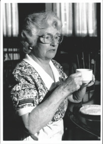
Photograph, Widows Club, 1991
A close up photo of a lady drinking a cup of tea. The photo featured in the March 1992 edition of the Widows' Newsletter which names her as Sue Sargent - Volunteer Helper. The date is assumed as 1991 due to the reference number from the photographic studio 911030 could mean 30 October 1991, along with 00645, 00646, 00647, 00648, 00649, 00651 and 00661 - 00666.Keesing Photographers took a series of photos on the same day of various ladies and some were committee members at different clubs. Presumably there had a been a meeting at Legacy House of members from the many clubs (including Hampton, Highett, Caufield).Black and white photo of a Legacy widow with a cup of tea and a proof sheet.Label on the back from Keesing Photographic with Reference No: 911030C-24. Pg 3 C in pencilwidows, widows club -
 Eltham District Historical Society Inc
Audio - Audio Recording, Peter Pidgeon; J.H. Clark Photos, 13 Aug 2022
EDHS Newsletter No. 265 August 2022 We are fortunate to have in our collection a wide range of early images of the Eltham district. Some of these are part of the Shire of Eltham Pioneers Photograph Collection (SEPP) held in partnership between the Eltham District Historical Society and the Yarra Plenty Regional Library (Eltham Library). Some are part of the group of photographs collected when the Pioneers and Painters book was published to commemorate the 1971 centenary of the Shire of Eltham. A prominent photographer of some of these early images is John Henry (Harry) Clark, whose background story is detailed in the article on page 7 of this newsletter. We are indebted to him for recording places and people that now are treasured reflections of days gone by. At our meeting at 2.00pm on Saturday 13th August 2022, we will explore some selected Clark images from our collection and with some try to show the current locations where these were taken.1:07:53 duration Digital MP3 file; 23.3MB Also PowerPoint presentation (compressed)audio recording, eltham district historical society, meeting, society meeting, eltham, j.h. clark photo, peter pidgeon -
 Melbourne Legacy
Photograph, Refreshments, 1996
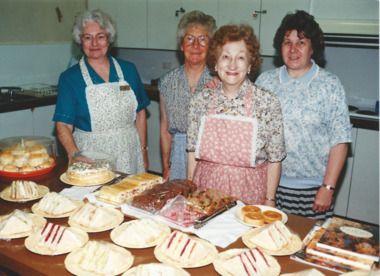
Photos of Legacy Widows, volunteers and staff, preparing food for visitors to Legacy House. Legacy House was open Monday to Friday with many events scheduled for Widows to participate in such as Tuesday craft sessions, painting lessons, stamp sorting and a cup of tea was always available. From a Widows' Newsletter the lady on the far left is Sue Sargent a volunteer helper. The paid kitchen lady is Audrey, seen on far right in striped skirt. Some of the photos were featured in the April 1996 edition of The Answer newsletter, which mentions 'Audrey and her band of volunteer helpers serve refreshments at minimal cost to all Legacy ladies calling into the Clubrooms, Monday to Friday 10 - 3:30pm.' "Legacy house at two nine three A good place for a chat and a cup of tea Monday to Friday, week in and out Something for everyone, there is no doubt So don't be lonely, don't be shy Come to the city and give us a try!!"A record of the type of activities Legacy provided as a social outlet for widows. Colour photo of widows preparing food at Legacy HousePrinted on the back "widows, answer, activities -
 Orbost & District Historical Society
framed photograph, early 20th century
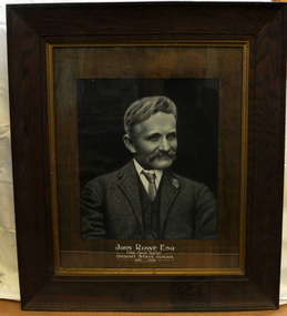
John Rowe began his teaching career at Orbost and Jarrahmond in 1886, a career which continued at Orbost until 1908 when he retired due to ill health. He began teaching at Orbost, (initially part-time with Jarrahmond) on 10th May 1886, following the very short tenure of the first appointee, Campbell MacKay. (more information Newsletter June 2018 - Lois Crisp)This item is associated with the history of education in the Orbost district.A large enhanced photograph in black / white of the head and shoulders of a moustached man in a suit.on front - "John Rowe Esq, First Head Teacher of Orbost State School"rowe-john education-orbost -
 Warrnambool and District Historical Society Inc.
Book, I fell down a beer cellar, 2004
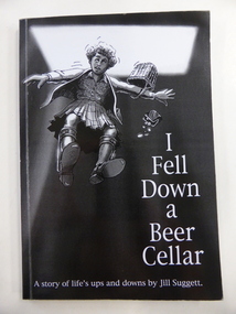
This is the autobiography of Jill Suggett, born 1940, the daughter of Lindsay and Enid Suggett of Warrnambool. She suffered from cerebral palsy and, in later life, bi-polar disorder. Despite this she lived a rich and active life, becoming a librarian and publishing several books. She was a member of the Warrnambool and District Historical Society and was the newsletter editor for the Society from 1968 to 1976 and was a Life Member of the Society. This book is of interest as it is the autobiography of Jill Suggett, a life member of the Warrnambool and District Historical Society (Jill is now deceased). This is a soft cover book of 120 pages. The cover has a black background and a black, grey and white image of a girl tumbling into a cellar. The lettering on the front cover is white and on the spine it is black. On the back cover there is a printed extract from the Foreword. The book has a Foreword, 21 chapters and several black and white photographs. The inscription is handwritten in blue biro. ‘Donated by Reg. Smith 2005’ history of warrnambool, jill suggett -
Glen Eira Historical Society
Article - Trinity Congregational Church, Glen Huntly
History of Trinity Congregational Church, Glen Huntly by J. O’ Donnell dated April 1973. Article tells where the church building came from, its features and how the land in Grange Road was obtained. How, after its removal from South Melbourne to Grange Road; it was re-erected a porch and timber cross were added. Source is Caulfield Historical Society Newsletter.trinity congregational church, gothic architecture, market gardens, primitive methodists, gables, glen huntly, grange road, towers, gas lighting, mercy g., porches, congregational union., rosstown sugarmill -
Eltham District Historical Society Inc
Document - Folder, Prentice, Jeff
Jeff Prentice attended Eltham Primary School 1946-1952. Contents Typed manuscript: "School Days at Eltham Primary" by Jeff Prentice. Letter: Jeff Prentice to Eltham District Historical Society, 1 March 2005. Plans to write a history of Eltham. Newsletter, Eltham District Historical Society, No 173, March 2007. Jeff Prentice's memories of Eltham Primary School days.Newspaper clippings, A4 photocopies, etcjeff prentice, eltham primary school, john arnaud, alan pitman, chris jarvis, ken docherty, max forster, sydney stevenson, david bell, braidwood arthur street eltham, adlingtons paddock eltham, stan jobbing -
 Eltham District Historical Society Inc
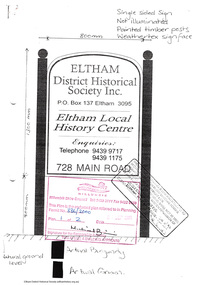
Document - Folder, Application for a street sign, 1999-2000
Folder 67 of the Harry Gilham Collection. Folder includes information and some duplication relating to the installation of a sign in front of 728 Main Road, Eltham by Eltham District Historical Society. Includes newsletter no 138, design of sign and related wording on sign, quotation by John Sharp Signs, Eltham, notes and planning permit submitted to Nillumbik Shire Council, and associated plans 1999-200030 pages in manilla foldereltham district historical society, planning permit, signage, john sharp signs, local history centre -
 Orbost & District Historical Society
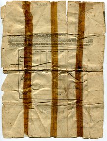
ticket, 1880's
The Potosi was built in Scotland in 1873 by John Elder and Co.It was a cargo/passenger iron screw steamer and sailed from 1880-1887 under the Orient Line Australia service. Samuel James Lynn was born in 1865 in Coleraine, Northern Ireland. Sam left his home in Coleraine in 1883 at the age of 17. (More information in O.D.H.S. newsletter No. 91 September, 2012 by Margaret Hollands) Samuel Lynn was a well-known Orbost pioneer. Ho owned much property throughout the district , bred Clydesdale horses and fattened about 600 cattle. He was in great demand as a judge of both cattle and horses at agricultural shows in Victoria and interstate. He was a shire councillor for 30 years and president several times. He took a great interest in the sporting clubs of the town and played cricket until late in life. He was goal umpire for the local football team for many years, judged for the Orbost Racing Club and was the first president of the Orbost Bowls Club. He was also a member of the first municipal band. A paper passenger's contract ticket for Samuel Lynn on the Steam Ship Potosi from Royal Albert Dock, Liverpool, United Kingdom to Melbourne, Australia. It is white with black print and hand-written details.front - signed "Samuel Lynn"lynn-samuel potosi-steamship