Showing 11164 items matching "planning "
-
 Port Melbourne Historical & Preservation Society
Plan - Structural Arrangement for gangway at Outer West berth, Station Pier, Port Melbourne, Port of Melbourne Authority, 1987
Plan - Structural Arrangement - Gangway Outer West Berth - Station Pierpiers and wharves - station pier, melbourne harbor trust - port of melbourne authority -
Port Melbourne Historical & Preservation Society
Plan - Proposed crossing, Rouse Street at Nott Street, George Kelly, Borough Surveyor, 27 Oct 1864
Place of Proposed Crossing in Rouse Street (Corner Nott Street) PlanGeo. Kelly, Cr.(?), Borough Surveyor, Sandridge, 27-10-1864engineering - roads streets lanes and footpaths, george kelly -
Port Melbourne Historical & Preservation Society
Plan - Proposed railway along Howe Parade to Webb Dock, 1973
Plan of proposed railway along Howe Parade to Webb Dock 1973R.C.B. drawing no 7931piers and wharves - webb dock, perce mcguire white, perce white -
Port Melbourne Historical & Preservation Society
Pamphlet - Brochure, cabin plan, P&O Orient Lines - SS Canberra, Sep 1964
Probably with materials from Station Pier kiosk, donated by Ted RohanPlan of first class accommodation on the P&O Orient liner Canberratransport - shipping, canberra, p&o lines -
Port Melbourne Historical & Preservation Society
Plan, B A Carter, Land Plan Primary School 1427 Port Melb, c. 1975
The design for extensive planting and landscaping of Nott Street Primary School, Port MelbournePlan of Landscape design for Nott Street Primary School, Port Melbourne.education - primary schools, nott street primary school -
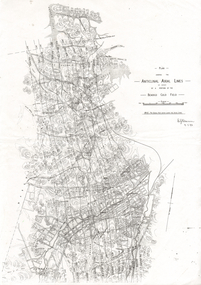 Bendigo Historical Society Inc.
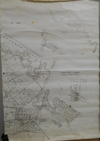
Document - LONG GULLY HISTORY GROUP COLLECTION: ANTICLINAL AXIAL LINES - BENDIGO GOLD FIELD
plan shewing the Anticlinal Axial lines of a portion of the Bendigo gold Field.bendigo, history, long gully history group, the long gully history group - anticlinal axial lines - bendigo gold field, e j dunn, christmas line, thistle line, carshalton line, napoleon line, nell gwynne line, new chum line, sheepshead line, deborah line, garden gully line, paddy's gully line, derby line, miller's line, hustlers line, lightning line -
 Bendigo Historical Society Inc.
Map - JACK FLYNN COLLECTION: TARNAGULLA SHEET 3, No date visible
Map: Parish of Tarnagulla Sheet 3, County of Gladstone. Parish plan.map, gladstone, parish plan, tarnagulla sheet 3 -
 Bendigo Historical Society Inc.
Map - JACK FLYNN COLLECTION: TOWNSHIP OF STANHOPE, December 1950
Map: Township of Stanhope, Parish of Girgarre, County of Rodney. Parish plan.By Authority J. J. Gourley, Government Printer, Melbourne. Drawn and Reproduced at the Dept, of Lands and Survey, Melbourne, Victoria.map, rodney, township, stanhope -
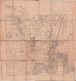
 Bendigo Historical Society Inc.
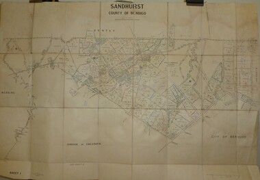
Map - JACK FLYNN COLLECTION: SANDHURST SHEET 6, January 1947
Map: Parish of Sandhurst Sheet 6. County of Bendigo. Parish plan.By Authority J. J. Gourley, Government Printer, Melbourne. Drawn and Reproduced at the Dept, of Lands and Survey, Melbourne, Victoria.map, bendigo, parish plan, sandhurst sheet 6 -
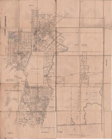
 Bendigo Historical Society Inc.
Map - JACK FLYNN COLLECTION: SANDHURST SHEET 2, January 1947
Map: Parish of Sandhurst Sheet 2, County of Bendigo. Parish plan.By Authority J. J. Gourley, Government Printer, Melbourne. Drawn and Reproduced at the Dept, of Lands and Survey, Melbourne, Victoria.map, bendigo, parish plan, sandhurst sheet 2 -
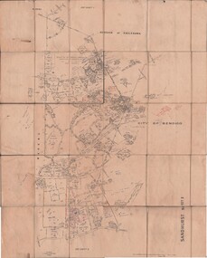
 Bendigo Historical Society Inc.
Map - JACK FLYNN COLLECTION: SANDHURST SHEET 1, January 1947
Map: Parish of Sandhurst sheet 1, County of Bendigo. Parish plan.map, bendigo, parish plan, sandhurst -
 Bendigo Historical Society Inc.
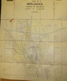
Map - JACK FLYNN COLLECTION: MOLIAGUL, 7/02/1931
Map: Township of Moliagul, Parish of Moliagul, County of Gladstone. Parish plan.map, gladstone, township, moliagul -
 Bendigo Historical Society Inc.
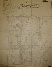
Map - JACK FLYNN COLLECTION: MOLIAGUL, October 1946
Map: Parish of Moliagul, Sheet 1, County of Gladstone. Parish plan.map, gladstone, parish plan, moliagul -
 Bendigo Historical Society Inc.
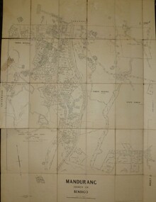
Map - JACK FLYNN COLLECTION: MANDURANG SHEET 2, March 1947
Map: Parish of Mandurang, Sheet 2, County of Bendigo. Parish plan.By Authority J.J.Gourley Government Printer Melbourne. Drawn and Produced at the Dept, of Lands and SurveyMelbourne, Victoria. March 1947.map, bendigo, parish plan, mandurang -
 Bendigo Historical Society Inc.
Map - JACK FLYNN COLLECTION: GIRGARRE, 1957
Map: Township of Girgarre, Parish of Kyabram, County of Rodney. Parish plan.By Authority: W. M. Houston, Government Printer, Melbourne. Drawn and reproduced at the Department of Lands and Survey, Melbourne.map, rodney, township, girgarre -
 Bendigo Historical Society Inc.
Map - JACK FLYNN COLLECTION: COHUNA, 1963
Map: Photocopy of parish plan showing Cohuna and a portion of the Gunbower Creek.By Authority. A.C. Brooks Government Printer, Melbourne. Drawn and Reproduced at the Department of Lands and Survey, Melbourne.1963.map, gunbower, parish plan, cohuna , gunbower creek -
 Bendigo Historical Society Inc.
Map - JACK FLYNN COLLECTION: BET BET, 18/08/1931
Map: Parish of Bet Bet, Counties of Gladstone and Talbot . Parish plan.By Authority H.J. Green Govt, Printer. Photo Lithographed at the Department of Lands and Survey, Melbourne. 18.8.31map, gladstone, parish plan, bet bet, counties of gladstone and talbot. -
 Bendigo Historical Society Inc.
Map - JACK FLYNN COLLECTION: GOORNONG, August 1953
Map: Township of Goornong, Parish of Goornong, County of Bendigo. Parish plan.By Authority W.M. Houston. Government Printer. Drawn and Reproduced at the Dept., of Lands and Survey, Melbourne, Victoria. August 1953map, bendigo, township, goornong -
Bendigo Historical Society Inc.
Map - SANDHURST (PART), Circa 1880's
Map: Parish plan showing Charleston Rd. Lloyd St. areamap, bendigo, parish plan, sandhurst, charleston road, lloyd street -
Bendigo Historical Society Inc.
Map - LYELL, 4/06/1873
Map: Lyell. Parish plan (number 278 in map cupboard 1)map, bendigo, parish plan, lyell -
 Bendigo Historical Society Inc.
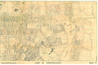
Map - SHIRE OF STRATHFIELDSAYE SHEET 3 PLAN OF PROPERTIES
large 97x65cm paper Shire of Strathfieldsaye Sheet 3 Plan of Properties-map, bendigo, shire of strathfieldsaye -
Tatura Irrigation & Wartime Camps Museum
Document, Geological Plan, Eildon Dam Site, 1945
To record details of geological aspects of EildonA series of maps illustrating rock formations etc., locations, boundaries and planswater/irrigation, documents, maps -
University of Melbourne, Burnley Campus Archives
Leaflet, Burnley Field Days'93, 1993
Leaflet promoting Burnley Field days to traders, incl. site planburnley, field days, 1993 -
 Canterbury Primary School
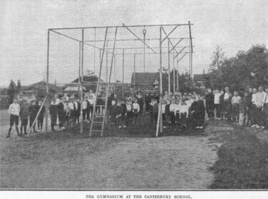
Photograph, Gymnasium
Gymnasium built to a design brought back to Canterbury from the USA. No longer there.2 Photographs and 1 plan of a gymnasium located on the north side of school. -
Koorie Heritage Trust
Book, Baragwanath, W, Memoirs of the Geological Survey of Victoria : No. 15 The Aberfeldy District, Gippsland, 1925
15 v. : ill., plates, maps, plans, diagrs. ; 34 cm. lcsh: 1. geology -- victoria -- periodicals. 2. geology -- victoria. i. geological survey of victoria. ii. victoria. dept. of mines. -
Whitehorse Historical Society Inc.
Document, Recreation strategy plan (2004 - 2009), 1/03/2004 12:00:00 AM
Report on recreation facilities within City of Whitehorse and proposals for future planning.Report on recreation facilities within City of Whitehorse and proposals for future planning.Report on recreation facilities within City of Whitehorse and proposals for future planning.city of whitehorse, sports and recreations, sportsgrounds, sporting clubs -
 Whitehorse Historical Society Inc.
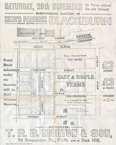
Document, Kings Padddock Blackburn
Plan showing land for sale at Kings PaddockPlan showing land for sale at Kings Paddock, Blackburn (second section).Plan showing land for sale at Kings Paddockauctions, kings paddock, blackburn, south parade, laburnum street, the avenue, fuchsia street, laurel grove, main street, t.r.b. morton & son -
Whitehorse Historical Society Inc.
Article, Career takes a leap forward, 1992
Nunawading's new Group Manager, Planning and Development, Ray Glickman, appointedNunawading's new Group Manager, Planning and Development, Ray Glickman, appointedNunawading's new Group Manager, Planning and Development, Ray Glickman, appointedglickman, ray, city of nunawading -
Whitehorse Historical Society Inc.
Map, Melbourne and Metropolitan Board of Works, 1925
1925 plan of the Yan Yean, Maroondah and O'Shannassy water supply systems.1925 plan of the Yan Yean, Maroondah and O'Shannassy water supply systems.1925 plan of the Yan Yean, Maroondah and O'Shannassy water supply systems.water supply, melbourne and metropolitan board of works -
Whitehorse Historical Society Inc.
Document, City of Whitehorse Arts and Cultural Strategy, 1/10/2003 12:00:00 AM
Outlines current status and proposed plans for artistic and cultural activities in the city.Outlines current status and proposed plans for artistic and cultural activities in the city.Outlines current status and proposed plans for artistic and cultural activities in the city.city of whitehorse, whitehorse centre, box hill community arts centre, schwerkolt cottage & museum complex