Showing 3220 items
matching road map
-
 Whitehorse Historical Society Inc.
Map, Nunawading Road District, 01/04/1863
... . Proclaimed Roads 149. Nunawading Road District Map Map ...Plan of proposed new road - April 1863 & estimated expenses.Plan of proposed new road - April 1863 & estimated expenses. Scale 20 chains per inch. Proclaimed Roads 149.Plan of proposed new road - April 1863 & estimated expenses.nunawading road district, roads and streets -
Whitehorse Historical Society Inc.
Map, Schwerkolt Cottage Historical Building, 1973
Plans for the construction of the Historical Museum in the grounds of Schwerkolt Cottage by the City of Nunawading.Plans for the construction of the Historical Museum in the grounds of Schwerkolt Cottage by the City of Nunawading.Plans for the construction of the Historical Museum in the grounds of Schwerkolt Cottage by the City of Nunawading.schwerkolt cottage & museum complex, museum -
Whitehorse Historical Society Inc.
Map, Proposed Mitcham Shopping Centre, 1979
Proposed shopping complex of Mitcham.Proposed shopping complex of Mitcham - site plan and ground floor tenancy layout. Four stages of development for this shopping centre by Clarke Hopkins and Clarke Architects included.Proposed shopping complex of Mitcham.mitcham shopping centre, city of nunawading, coles supermarket, mitcham -
Whitehorse Historical Society Inc.
Map, Tunstall 1945, 1945
A map drawn from memory about 20 years ago by Colin Fraser of the businesses and residents of Tunstall, 1945, including the location of Fraser General Store.A map drawn from memory about 20 years ago by Colin Fraser of the businesses and residents of Tunstall, 1945, including the location of Fraser General Store.A map drawn from memory about 20 years ago by Colin Fraser of the businesses and residents of Tunstall, 1945, including the location of Fraser General Store.tunstall, tunstall railway station, tunstall avenue nunawading, tunstall state school no 4190, fraser, colin -
 Whitehorse Historical Society Inc.
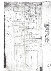
Map, Shire of Nunawading 1888
Plan showing owners of land in the South Riding of the Shire of Nunawading, 1888. South Boundary Road is now Highbury Road.shire of nunawading. south riding, south boundary road, burwood east, highbury road, springvale road, mahoneys road, forest hill, holland road, blackburn south, burwood highway -
 Whitehorse Historical Society Inc.
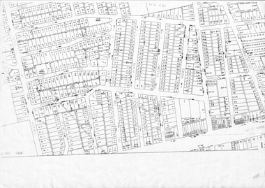
Map, Cadastral map, ca 1955
Cadastral map showing house and lot numbers (ca 1955) in Mitcham.plans, ormond avenue, mitcham, hardwood court, bruce street, page street, victoria avenue, mitcham road, whitehorse road, dunlavin road, doncaster east road, harrison street, william street, alexander street, fellows street, peel street, milne street, albert street, edward street, shirley court, burnett street, haines street -
 Whitehorse Historical Society Inc.
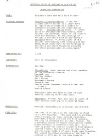
Document, Landscape Submission, c 1976
A landscape submission written for the National Trust of Australia (Victoria) for Blackburn Lake and the Bell Bird Streets.A landscape submission written for the National Trust of Australia (Victoria) for Blackburn Lake and the Bell Bird Streets. Definitions given of boundaries of the Lake area, ownership, housing and gardens. Photographs and map.A landscape submission written for the National Trust of Australia (Victoria) for Blackburn Lake and the Bell Bird Streets.blackburn lake sanctuary, waratah crescent, blackburn, jeffery street, hill street, boongarry avenue, linum street, laurel grove, acacia avenue, city of nunawading, melbourne and metropolitan board of works, furness park, camberwell grammar school -
Whitehorse Historical Society Inc.
Document, Mitcham before 1940s, 1970s?
Four pages of sketch maps of Mitcham business areas.Four pages of sketch maps of Mitcham business areas. Includes: brief history of three hotels; Timeline of development 1851-1971; Details from 1924 Census re local traffic; Details from 1854 Census re populationnon-fictionFour pages of sketch maps of Mitcham business areas. hill hotel, mitcham, mitcham hotel, australia. census 1854, census 1924, traffic, mitcham road mitcham, station street mitcham, britannia street mitcham, whitehorse road mitcham, harvest home hotel -
Whitehorse Historical Society Inc.
Map, Kylana Estate Tunstall, 1926
Auctioneer's plan of sub-division of Kylana Estate Tunstall.Auctioneer's plan of sub-division of Kylana Estate Tunstall, 8 sites, 2nd Oct 1926. Auctioneer: Sergeant & LehmannAuctioneer's plan of sub-division of Kylana Estate Tunstall.heather grove tunstall, kylana estate, springvale road tunstall, tunstall -
Whitehorse Historical Society Inc.
Map, Blackburn Heights Estate, 1923
Auction plans of sub-division for Blackburn heights Estate.Auction plans of sub-division for Blackburn heights Estate, 130 sites, 8th December 1923Auction plans of sub-division for Blackburn heights Estate.springfield road blackburn north, surrey road blackburn north, gordon street blackburn north, koonung road blackburn north, harris street blackburn north, hirst street blackburn north, deane street blackburn north, blackburn heights estate, blackburn north -
Whitehorse Historical Society Inc.
Document, Fromelles, 2012
Transcription of talk on the Battle of Fromelles.Transcription of talk on the Battle of Fromelles by Lambos Englezos to Whitehorse Historical Society 14 April 2012. With map of battle area. Tape at NP 3908Transcription of talk on the Battle of Fromelles.world war 1914-1918, fromelles -
Whitehorse Historical Society Inc.
Map, Sands and McDougall's Map of Melbourne & Suburbs, 1950s
... Whitehorse Historical Society Inc. 2-10 Deep Creek Road ...Wall map of Melbourne and suburbs 12-18 mile radius of CBD.Wall map of Melbourne and suburbs 12-18 mile radius of CBD.Wall map of Melbourne and suburbs 12-18 mile radius of CBD.melbourne, maps -
Whitehorse Historical Society Inc.
Map, Ringwood, 1935
Australia Ringwood and area map.Australia1:63,360 series map, Ringwood N.849 Zone 7. Scale 1 inch to 1 mile. Approximate scope: Prahran-Cockatoo, Lilydale-DandenongAustralia Ringwood and area map.maps, ringwood -
Whitehorse Historical Society Inc.
Map, Schwerkolt Museum Extension 2010, 1/06/2010 12:00:00 AM
Plans for construction of an extension of the museum building of the Schwerkolt Cottage & Museum Complex (Visitor Centre).Plans for construction of an extension of the museum building of the Schwerkolt Cottage & Museum Complex (Visitor Centre). Lovell Chen, Architects.Plans for construction of an extension of the museum building of the Schwerkolt Cottage & Museum Complex (Visitor Centre).schwerkolt cottage & museum complex, museum building -
 Whitehorse Historical Society Inc.
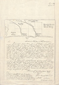
Document - Correspondence, Anderson's Station, 2/10/1842
Photocopy of a letter from James Anderson dated 2 October 1842 complaining of incursions by stock of Major Newman on Anderson's adjoining land. Includes sketch map of relative locations of neighbouring runs bordered by the Yarra River.anderson, james, newman, (major), dawsons station, ross station, yarra river, agriculture, pioneers, deep creek, nunawading -
 Whitehorse Historical Society Inc.
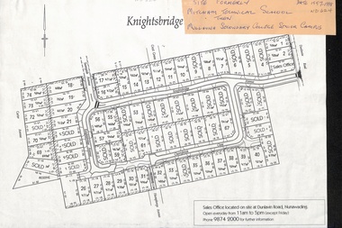
Map, Knightsbridge Estate, Nunawading, Ca 1997 - 1998
Plan of subdivision of former Mitcham Technical School and later Mullauna Secondary College Senior Campus - Knightsbridge Estate.land subdivision, knightsbridge estate, mitcham technical school, mullauna secondary college, senior campus, cherrybrook close, nunawading, knightsbridge avenue, sunnyside avenue, crest grove, dunlavin road, mitcham, carter avenue, humphreys avenue -
Whitehorse Historical Society Inc.
Map, Map Of The Entire City Of Nunawading, 1920s?
City of Nunawading published by Frank Fisher & Co. Estate Agents.City of Nunawading published by Frank Fisher & Co. Estate Agents.City of Nunawading published by Frank Fisher & Co. Estate Agents.city of nunawading, maps -
 Whitehorse Historical Society Inc.
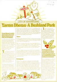
Pamphlet, Yarran Dheran: a bushland park, 1/10/1982
Pamphlet explaining the history and development of Yarran Dheran. A map is included and features and attractions including Schwerkolt Cottage.bushland, yarran dheran, mullum mullum creek, city of nunawading, schwerkolt, johann august, quarries -
Whitehorse Historical Society Inc.
Map, Alterations to residence, 1/02/1979 12:00:00 AM
Plans of proposed alterations and additions to residence for Mr. R. Doreian.Plans of proposed alterations and additions to residence for Mr. R. Doreian at 567 Whitehorse Road, Mitcham Scale 1:100,500|2 copies, 1 stamped APPROVEDPlans of proposed alterations and additions to residence for Mr. R. Doreian.dorien, bob, whitehorse road, mitcham no.567 -
Whitehorse Historical Society Inc.
Map, Mitcham RSL Meeting Hall, 4/12/1963 12:00:00 AM
Working drawing including elevations & sections for the new RSL Meeting Hall in Mitcham.Working drawing including elevations & sections for the new RSL Meeting Hall in Mitcham. Architect: Bates Smart & McCutcheon.Working drawing including elevations & sections for the new RSL Meeting Hall in Mitcham. mitcham returned servicemen's league, mcdowall street, mitcham, harrison street, mitcham -
Whitehorse Historical Society Inc.
Map, Mitcham RSL building, 6/08/1964 12:00:00 AM
Working drawing including pans and elevations for the new RSL building, centre section, in Mitcham.Working drawing including pans and elevations for the new RSL building, centre section, in Mitcham. Architect Bates Smart & Mc Cutcheon.Approved by Nunawading Council 21 Sep 1964.With City of Nunawading Notice to Builders.Working drawing including pans and elevations for the new RSL building, centre section, in Mitcham.mitcham returned servicemens league, mcdowall street, mitcham, harrison street, mitcham -
 Whitehorse Historical Society Inc.
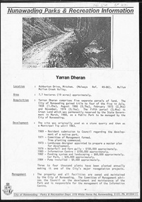
Document, Yarran Dheran, ?1985
Information brochure on development and features of Yarran Dheran Reserve, including map. Prepared by City of Nunawading Parks and Recreation Department, ?1985.yarran dheran, parks and reserves -
Whitehorse Historical Society Inc.
Map, Proposed layout at car park for Mitcham RSL, 14/12/1972
Plan of car park for proposed Mitcham RSL, McDowall Street, Mitcham.Plan of car park for proposed Mitcham RSL, McDowall Street, Mitcham. Architect: L.R.Saward. Amended 19 Feb.1973. Approved by Nunawading Council 16 Mar 1973.Plan of car park for proposed Mitcham RSL, McDowall Street, Mitcham. mitcham returned servicemens league, mcdowall street mitcham -
 Whitehorse Historical Society Inc.
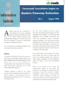
Pamphlet, Eastern Freeway Extension, 1/08/1998 12:00:00 AM
Information bulletin giving history map showing features of extension,Information bulletin giving history map showing features of extension, members of liaison group established for consultation.Information bulletin giving history map showing features of extension,freeways, springvale road, nunawading, mitcham road, mitcham, park road, mullum mullum creek, deep creek road, loughnan road, ringwood, harrison street, acacia court, maroondah highway, city of whitehorse, city of manningham, city of maroondah, melbourne water, victoria. department of natural resources and environment, environment protection authority, victoria, vicroads, eastern freeway -
Whitehorse Historical Society Inc.
Book, The Herald Road Guide, 1930's
A Road Guide Book of Victoria and routes to Sydney, Brisbane, Canberra, Adelaide and Alice Springs.A Road Guide Book of Victoria and routes to Sydney, Brisbane, Canberra, Adelaide and Alice Springs.A Road Guide Book of Victoria and routes to Sydney, Brisbane, Canberra, Adelaide and Alice Springs.maps, tourism, australia, victoria -
Whitehorse Historical Society Inc.
Map, Eastern Suburbs, 1922
... Whitehorse Historical Society Inc. 2-10 Deep Creek Road ...Enlargement of sections of 1922 Ringwood Commonwealth Survey - Imperial General Staff (West - Camberwell; North - Templestowe; East - Ringwood; South - Clayton)maps, nunawading, tunstall, box hill, blackburn, mitcham, vermont, burwood east, mont albert -
Whitehorse Historical Society Inc.
Pamphlet, Getting about Nunawading, 1990's
Maps of schools, parks, bicycle and public transport routes in the City of Nunawading.Maps of schools, parks, bicycle and public transport routes in the City of Nunawading.Maps of schools, parks, bicycle and public transport routes in the City of Nunawading.public transport, city of nunawading -
Whitehorse Historical Society Inc.
Map, Mullauna College, 2015
Plan of proposed extensions to Mullauna College at an Open Day 21 Jun 2015.Plan of proposed extensions to Mullauna College at an Open Day 21 Jun 2015. Brand Architects, Wellington Parade, East Melbourne.Plan of proposed extensions to Mullauna College at an Open Day 21 Jun 2015.mullauna secondary college, extensions -
Whitehorse Historical Society Inc.
Map, Nunawading, 1965
... Whitehorse Historical Society Inc. 2-10 Deep Creek Road ...Map of Nunawading and surrounds: Eltham, Templestowe, Doncaster, Box Hill, Warrandyte, Park Orchards, Ringwood, Croydon, Lilydale and Mooroolbark .Map of Nunawading and surrounds: Eltham, Templestowe, Doncaster, Box Hill, Warrandyte, Park Orchards, Ringwood, Croydon, Lilydale and Mooroolbark . UBD map issued by Gazette Newspapers. Scale: 1:50,000Map of Nunawading and surrounds: Eltham, Templestowe, Doncaster, Box Hill, Warrandyte, Park Orchards, Ringwood, Croydon, Lilydale and Mooroolbark . blackburn, nunawading, vermont, forest hill, burwood east -
Whitehorse Historical Society Inc.
Map, Mitcham, 1880s?
... Canterbury Road Mitcham Hand drawn map of area north and south ...Hand drawn map of area north and south of Whitehorse Road and South of Canterbury Road c.1880-1900.Hand drawn map of area north and south of Whitehorse Road and South of Canterbury Road c.1880-1900. Probably sketched by a McClare descendant. Includes locations and names of settlers of that time.Hand drawn map of area north and south of Whitehorse Road and South of Canterbury Road c.1880-1900. whitehorse road, mitcham, mitcham road, mitcham, l l vale road, vermont, canterbury road, mitcham