Showing 3382 items
matching bridge road
-
 Glenelg Shire Council Cultural Collection
Photograph - Photograph - Blairs Bridge over Salt Creek, c. 1970
Photographic print of a rephotographed photograph. Image shows wooden bridge and Blair's Bridge over Salt Creek. Flagstaff and Lighthouse Keeper's quarters on Observatory Hill. -
Glenelg Shire Council Cultural Collection
Photograph - Photograph - Portland scene, c. 1970
... Cliff Street Portland great-ocean-road Front: 'Bridge over ...Photographic print of a rephotographed photograph. Image shows lower north slope Observatory Hill, fence along base, then wooden bridge over Salt Creek that drains into bay, near the Spit Portland.Front: 'Bridge over Portland drain' - green ink -
Glenelg Shire Council Cultural Collection
Photograph - Sheet of 12 contact prints - Various historic Portland buildings and Landmarks, c. 1970
Sheet of 12 contact prints of rephotographed photographs. Identifying numbers 5726 a, b, c, d, e, f, g, h, i, j, k, l (a) S.S. 'Dawn' at Railway Pier (b) Macs Hotel (c) Dr. C. Grier, Res. Julia Street (d) Bentinck Street, South from All Saints (e) Captain James Fawthrop (f) Bridge over Salt Creek (g) 'Prospect' (h) 'Windsor Cottage' (i) Bentinck Street from sea (j) London Hotel (k) 'Greenmount' (l) British fleet at anchor in Portland BayFront: (b) Macs Hotel (l) British fleet in portland Bay, Sept 30 1891 CN-865-G -
Glenelg Shire Council Cultural Collection
Negative - Glass Plate Negative - Bridge across Salt Creek with 'Kingsley' in background, c. 1890
Glass plate negative. Image shows the bridge across Salt Creek with 'Kingsley' in background. -
Glenelg Shire Council Cultural Collection
Negative - Glass Plate Negative - Man with a bicycle near a bridge, c. 1890
Stereoscopic glass plate negative. Image shows a man with a bicycle standing at one end of wooden bridge. -
 Greensborough Historical Society
Photographs, Greensborough Views, 1900c
... & district in the early 1900's. Records the houses, roads and bridge ...Various views of Greensborough & district in the early 1900's.Records the houses, roads and bridge in Greensborough.2 copies of early Greensborough district photographs.Nilgreensborough, bluestone bridge, main street, aqueduct bridge, plenty river -
 Greensborough Historical Society
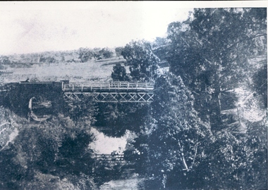
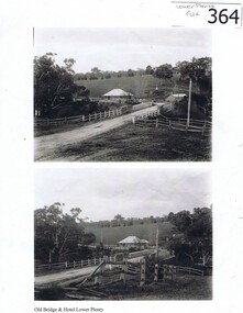
Photograph (copy), Old Bridge and Hotel Lower Plenty, 1925c
2 historical views of the Lower Plenty bridge and hotel. Original photographs are in the Victorian State Library collection.Both the bridge and hotel remain but are in a very different landscape. This shows the area about 110 years ago.A4 photocopy of 2 black and white photographslower plenty, lower plenty hotel, plenty river, lower plenty river bridge. -
 Greensborough Historical Society
Report, Examining Draughtsman's Report - Watts River Aqueduct, 20/07/1897
This Field Survey was commissioned by the Melbourne Board of Works and was used to position the Maroondah Aqueduct bridge north of Greensborough at its crossing point on the Plenty River. It incorporated the use of wrought iron water pipes and therefore is of lighter construction than other similar bridges in the district. It features a traverse of the Plenty RiverThe Maroondah Aqueduct bridge is a significant example of late 19th century engineering. A 4 page reproduction of an Office of Titles document. Copy of handwritten report includes maps.maroondah aqueduct, watts river aqueduct, bridge, greensborough, office of titles, 1897, wrought iron water pipes, plenty river, melbourne board of works -
 Halls Gap & Grampians Historical Society
Photograph - B/W
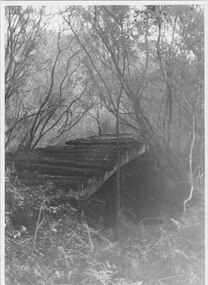
Photo shows old rail bridge, surrounded by bush & passing over what appears to be a creek. Bridge is supported by wooden trestles. structures, bridges -
 Halls Gap & Grampians Historical Society
Photograph - B/W, C 1880
1880-1902 Land owned by Robert and Sarah Graham who owned a large portion of land best described as Upper Fyans Valley. At some time after 1880, they sold a parcel of the land under Sundial Peak to David Austin who built a slab hut. C1896, The land was sold to James and Amy Balmain which they named 'Bellfield' Amy was a daughter of John D/Alton who built the Stawell Water Supply System. Balmain purchased the vacant school cottage at Burnt Bridge and moved it to 'Bellfield' Over the next six years the house was enlarged to accommodate their growing family but sold in 1902 following the death of Amy Balmain.House with addition People leaving house by horse and carriage, people standing in groundsState Library Victoria, Rose's Australasian Views Victorian Series photographed and published by George Rose 123 Chapel St., Windsor, Victoriabuildings, houses, bellfield -
 Halls Gap & Grampians Historical Society
Photograph - Sepia
Myrtlebank before bridgeGuest House before bridge Appears to be taken from post card photoThe rose Series P 4971accommodation, guesthouses, myrtlebank -
 Halls Gap & Grampians Historical Society
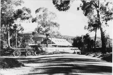
Photograph - B/W, C 1918
Early stages of guest houseGuest House and grounds Driveway leading up to house has a wagon in foreground before the bridge was builtAgfa Quality paper made in Germanyaccommodation, guesthouses, myrtlebank -
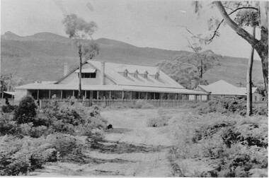
 Halls Gap & Grampians Historical Society
Book - B/W
Norval Guest-House Aginda and Wettenhall The original Norval The story of Norval begins in 1917 when it was built as a private residence for Mr and Mrs William Thompson. Mrs Thompson was a pioneer of the tourist business, having come from Ballarat to Hall's Gap in 1909 to manage Bellfield Guest-house According to Ida Stanton, in her history of Hall's Gap entitled "Bridging the Gap", Mr Thompson and his wife acquired the six roomed shearers quarters at "Hankelow", on land leased by the Wettenhall family, on the south side of Bellfield. Mr Thompson, she says, completely dismantled the quarters, carefully marking each board, then hired George McKeon to cart the material up to where the original Norval house stood. With great care, the rooms were rebuilt into a home for William and his wife Mathilda. Catherine Good, the daughter of Viola (nee Wettenhall) and niece of Dr Roland, in here "Recollections" entitled "Look to the Mountains - Viola's View 1887-1979", mentions Hankelow. Speaking of her days at Glen Holford, the Wettenhall home at Pomonal, Viola says "Verona and Francie Dennis, my cousins, and I went for one very exciting trip. Father (i.e Dr Roland's father) had bought 300 acres in the Gap to take sheep from Carr's Plains in time of drought, and had a little cottage there with one of the Glen Holford men and his wife in charge. It was called Hankelow. So we three set off over the Range from Glen Holford on foot and leading a pack horse with our night attire and no doubt sponge bags. "We stayed the night at Hankelow with Jim and Minnie. Minnie had been a housemaid at Glen Holford. I was very fond of her. It makes one laugh to think of the excitement of "roughing it"! Minnie gave us a lovely dinner with meringues, and cream, I remember, then early morning tea. After breakfast we were driven in the buggy to the foot of the Goat Rock (since renamed Mt Rosea) and off we went - walking in our long skirts and ankle boots. There was no track of any kind, nor blazed trail - we just made for the top. It was rather frightening at times because we couldn't see where the top was an it always seemed to get further and further away. The last mile was so terribly steep, with a lot of lose shale where you went up twelve inches and slipped back six. Now you motor to about a couple of miles from the top and then have a graded path. Anyway, we got there and back safely and were rewarded with a magnificent view" By a strange coincidence, Hankelow, the source of Norval Guest-house in times past (if the name can be applied to the property as a whole, which seems likely) is in fact also the source of our Wettenhall Campsite! Hankelow was named after a property owned by the Wettenhall family in England. In 1917 William and Mathilda retired to their newly built home (Norval) "to escape from the tourist business" However, so many people made requests to stay with them that they found it necessary to add several more rooms and sleepouts to their home. In this way, early in 1921, the guest-house began to take shape. Mr Thompson, a former librarian of the Mechanics Institute in Ballarat, named the house "Norval". The name "Norval" comes from a quotation from the play 'Douglas" by John Home. Written in the mid-16th century the play is set in the Grampian Mountains of Scotland. The story is of a boy who was parted from this mother during his early childhood, and was given to a shepherd who raised him. Some eighteen years later the mother by chance happens to meet here son, and not knowing his true identity, asks his name. He answers, "My name is Norval; and in the Grampian hills my father feeds his flocks." Perhaps it was simply because "Norval" was associated with the "Grampians" that it was chosen by Mr Thompson. He may also have been conscious of feeding "flocks" of tourists in his expanding, guest-house. Norval Guest-house prospered. It was known for its fine cooking and friendly atmosphere - a tradition which has carried through to the modern Norval! It closed between 1940 and 1949 because of the second world war. In 1949 it was decided to almost completely rebuild the house. Most of the old building (Hankelow plus) was demolished and rebuilt to a much larger and more modern plan. And then, on May 1, 1965, it was purchased by the Committee of Management of the Methodist and Presbyterian Conference Centres. At this time the guest-house was owned and operated by Marjorie and Lachland McLennan, Mrs McLennan being the daughter of William and Mathilda Thompson, the pioneers of the establishment. The McLennans had operated the Guest-house since about 1930.Photocopy 2 pages of article from book titled 'In the Making' title of article Norval guest House the original Norvalaccommodation, guesthouses, norval -
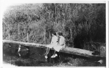 Halls Gap & Grampians Historical Society
Photograph - B/W
Photo shows 2 women sedated on wooden footbridge over the Wannon riverstructures, bridges -
 Halls Gap & Grampians Historical Society
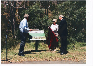
Photograph, 2004
2004Photo shows Joe Helper MP, Janet Witham, Historian and Robert Irwin, Mayor at the official opening of the new Delley's Bridge at the entrance to Hall's Gappeoplestructures, bridges -
 Halls Gap & Grampians Historical Society
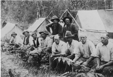
Photograph - Sepia, C 1909
Grampians halls Gap at Stoney Creek Dredge. The site of the Stoney Creek diggings was in the upper catchment area of the creek, beside Silverband Road. For further information see: 'Bridging the Gap' by Ida Stanton, p. 49 and 'Victoria's Wonderland' by Halls Gap and Grampians Historical Society, p. 41.Photo shows eight men seated, two standing, 3 tents in background. 2nd right Alfred D'Alton 4th Right James Oliverwater supplies, d'alton, water supplies, channels -
 Halls Gap & Grampians Historical Society
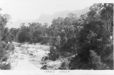
Photograph - B/W
Photo shows Fyans Creek, looking South West towards the Pinnacle. View probably taken from the bridge. Fyans Creek appears to be very wide, perhaps after a flood.scenery, fyans creek -
 Halls Gap & Grampians Historical Society
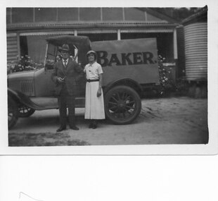
Photograph, C 1930s
Wilfred (Fred) Warren and niece Ida Warren (who later married Robert Greer). They are shown standing in front of Warren's Bakery van, which is parked in front of their house. Warren bakery was started in 1929 by John Warren, his wife Florence, their daughter Ida and an aunt Miss Vine. see Bridging the Gap p.58A man and a woman standing in front of a truck marked "Baker.". There is a house in the background.people, warren, transport, trucks -
 Halls Gap & Grampians Historical Society
Photograph - B/W, C 1880
This photo shows the first Delley's Bridge, built to cross the Fyans Creek to provide access to Halls Gap and beyond in the 1880's. The bridge was swept away a number of times in floods. This bridge was replaced by a higher timber structure but constant erosion of the creek bank eventually led to its replacement by a timber and concrete structure. After nearly 50 years of its use, wear and tear necessitated a fourth bridge to be erected in 2001.A log bridge across a creek with a man standing on the bridge. A woman in a white dress and hat is beside the creek and a man is standing near her on the bank. In the left background a house can just be seen through the trees.structures, bridges -
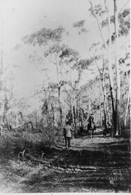 Halls Gap & Grampians Historical Society
Photograph - B/W, C 1880s
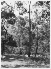
... This photo is of the road approaching Delley's Bridge... is of the road approaching Delley's Bridge. It shows methods of transport ...This photo is of the road approaching Delley's Bridge. It shows methods of transport and the access route to Halls Gap in the late 19th Century.A man with a walking stick walking away from the camera on a rutted dirt road through trees and bush. Another man is approaching from the opposite direction on horseback.access routes, roads -
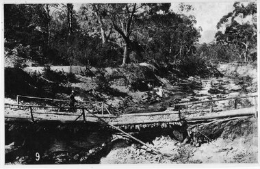
 Halls Gap & Grampians Historical Society
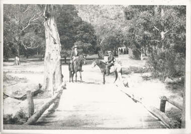
Photograph, C 1911
... . access routes roads structures bridges The photo shows a dirt ...This is the second Delley''s Bridge. A new and more substantial bridge was built in 1911, only to be badly damaged in a 1917 flood. The collapsed western end was rebuilt, this time supported by concrete pillars.The photo shows a dirt road crossing a creek via a wooden bridge. A woman is driving a horse and buggy onto the far end of the bridge. There are ferns in the foreground and trees in the background.access routes, roads, structures, bridges -
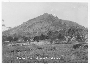 Halls Gap & Grampians Historical Society
Photograph, C 1910s
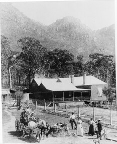
This is a picture of Sentinal Peak, showing Delley's Bridge and Delley's house. This is the second bridge built over Fyans Creek in 1911. The house is Delley's Inn, which became a regular stop-off for thirsty travellers.The photo shows a rocky peak. In the middle distance, in front of the peak, is a house on the left and on the right a wooden bridge can be seen crossing a creek. In the foreground is the creek with a fenced paddock in front of it.access routes, roads, scenery, peaks -
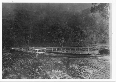
 Halls Gap & Grampians Historical Society
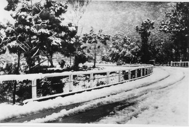
Photograph - B/W, C 1940
The third Delley's Bridge, built in 1940 with a curved deck, was situated slightly upstream from the previous bridge. Though it was subject to snow cover from time to time, raging floodwaters were not a threat after Bellfield Dam was built in the 1960s.The picture shows a curving bridge with a wood and wire railing. The bridge and surrounding trees are covered in snow.structures, bridges -
 Halls Gap & Grampians Historical Society
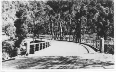
Photograph - Photocopy, C 1930s
... railing. An unsurfaced road crosses the bridge and the area.... An unsurfaced road crosses the bridge and the area is surrounded ...The third Delley's Bridge, a timber and concrete structure with a curved deck, built in 1940. It was situated slightly upstream from the previous bridge. After nearly 50 years of its use, wear and tear necessitated a fourth bridge to be erected in 2001.The picture shows a curving bridge with a wood and wire railing. An unsurfaced road crosses the bridge and the area is surrounded by trees.structures, tents -
 Halls Gap & Grampians Historical Society
Photograph - B/W, C 1920s
The Stoney Creek dray bridge. Stoney Creek has been bridged a number of times on school road since the creek was re-routed in the early 1900s. A dray bridge was built C 1910 by local residents, which stood them in good stead for more than a decade. This bridge was replaced by a higher timber structure. Image two is a story from 1906 relating to Marshall White and his family trying to recross Delley's bridge after finding the Stoney Creek dray bridge washed away.Photo of two men on horseback on a wooden bridge with low log railing. A shelter can be seen in the background and there are thick trees surrounding the road.structures, bridges -
 Halls Gap & Grampians Historical Society
Photograph - B/W, C 1940- (before 1950)
Stoney creek has been 'bridged' a number of times in School Rd, since the creek was re-routed in the early 1900's. A dray bridge was built c1910 by local residents which stood them in good stead for more than a decade.Photo of 'school bridge' over Stoney Creek. Gravel road in foreground leading to a wooden bridge surrounded by tall gum trees.structures, bridges -
 Halls Gap & Grampians Historical Society
Photograph - B/W, C 1933
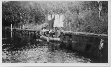
The photo shows the Wannon River in flood. Augustus (Gus) Knight built the footbridge. The boat was constructed using kerosene tins or honey tins.Photo shows five adults, four standing and one squatting, on a foot bridge. There are four children in front of them in a boat.structures, bridges -
 Halls Gap & Grampians Historical Society
Photograph - B/W, C 1933
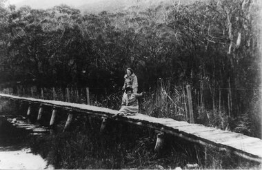
The photo shows "Knight's Bridge" at the Wannon River Crossing.Photo shows two women, one sitting and one standing leaning on the other woman's shoulder. They are on a wooden footbridge with water in the foreground and thick bush in the background.structures, bridges -
 Halls Gap & Grampians Historical Society
Photograph - B/W, C 1970s (?)
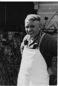
Robert Greer was the Hall's Gap baker. He married Ida Warren and they had a daughter Rae. Robert & Ida inherited the bakery from Ida's father John Warren who established the business in 1929. For further details see Bridging the Gap, p.56Photo shows man (Robert Greer) in an apron standing outside his house.people, greer, buildings, bakery -
 Halls Gap & Grampians Historical Society
Photograph - B/W, C 1950s (?)
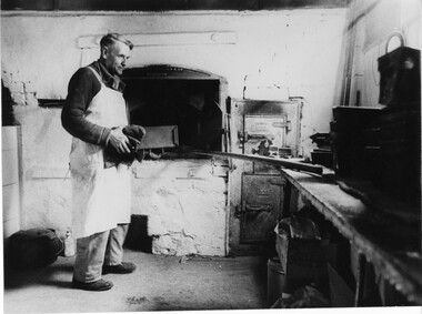
Robert Greer, baker, married Ida Warren whose family started the bakery; in 1929. Robert & Ida inherited the Bakery from Ida's father John Warren. for further information see Bridging the Gap p. 56Photo shows Robert Greer, baker standing with a load tin in his hands, inside the bakery. Baking tins & ovens can be seen in the photo.Folio no.48 Negative no.25people, greer, buildings, bakery