Showing 110058 items matching "roads"
-
 Ringwood and District Historical Society
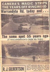
Newspaper - Photographs and Clippings, Article comparing Warrandyte Road, Ringwood, in 1912 and 1967
Newspaper cutting showing a photos of Warrandyte Road, taken from Mullum Mullum Road, in 1912 and 1967.Extract from Eastern Post Gazette 13 December 1967, page 39 -
 Ringwood and District Historical Society
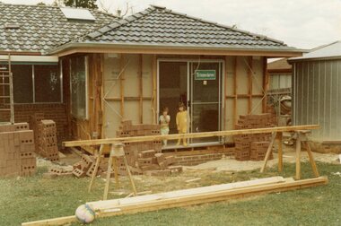
Photograph, Adding a room onto the Mitchell house at 168 Oban Road, North Ringwood in February 1979
Near the corner of Cormistom Road and Florence Avenue onto Oban Road. The house is still there today (2024).Taken by Roy J Mitchell -
 Whitehorse Historical Society Inc.
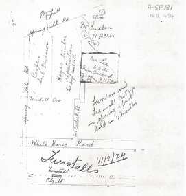
Document, 1924 Tunstall Properties, 11/02/1924 12:00:00 AM
Hand drawn plans of properties bordered by Tunstall (Nunawading) Railway Station,Hand drawn plans of properties bordered by Tunstall (Nunawading) Railway Station, Springvale Road and Springfield Road.Hand drawn plans of properties bordered by Tunstall (Nunawading) Railway Station, plans, whitehorse road, nunawading, tunstall railway station, tunstall avenue, springvale road, springfield road, luxton, lee, mcculloch street, hayes timber, cooper, land subdivision -
 Whitehorse Historical Society Inc.
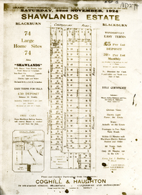
Document, Shawlands Estate, 22/11/1924 12:00:00 AM
Notice of Sale of land Holland Road and Canterbury RoadNotice of Sale of land Holland Road and Canterbury Road Blackburn Original in Haughton Maps LaTrobe LibraryNotice of Sale of land Holland Road and Canterbury Road land subdivision, canterbury road, blackburn south, holland road, shawlands avenue, coghill & haughton, shawlands estate, haughton map collection, state library of victoria. latrobe library -
 Whitehorse Historical Society Inc.
Document - Correspondence, Healesville Road, 1/09/1937
Claim for reimbursement from Country Roads Board for amounts expended on the Burwood Road by Shire of Blackburn and Mitcham.burwood road, roads and streets, shire of blackburn and mitcham, victoria. country roads board -
Whitehorse Historical Society Inc.
Document - Correspondence, Burwood Road, 25/11/1937
Claim for reimbursement from Country Roads Board for amounts expended on Burwood Road by Shire of Blackburn and Mitchamburwood road, shire of blackburn and mitcham, victoria. country roads board, roads and streets -
Whitehorse Historical Society Inc.
Document - Correspondence, Burwood Road, 16/12/1937
Claim for reimbursement from Country Roads Board for amounts expended on Burwood Road by Shire of Blackburn and Mitchamshire of blackburn and mitcham, victoria. country roads board, burwood road, roads and streets -
 Whitehorse Historical Society Inc.
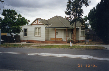
Photograph, Whitehorse Road, Mitcham No.427, 21/12/2001 12:00:00 AM
Coloured photograph of 427 Whitehorse Road, Mitcham showing Dunlavin Road side of house being renovated.whitehorse road, mitcham, no.427 -
 Whitehorse Historical Society Inc.
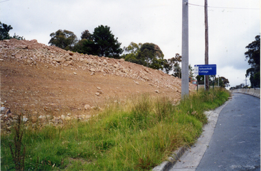
Photograph, Bridgeworks - Mitcham
Coloured photograph of earthworks on side of road during bridge construction along Deep Creek Road, Mitchamdeep creek road, mitcham -
 Whitehorse Historical Society Inc.
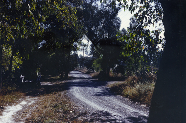
Photograph, Glenburnie Road, Vermont, 1967
Part of Tim Shambrook's Collection for 'This is Vermont'. Not used.Coloured photo of Glenburnie Road, Vermont, taken in 1967, showing dirt track before road was made.glenburnie road, vermont, shambrook, tim -
 Whitehorse Historical Society Inc.
Photograph, Mitcham Methodist Church
Mitcham Methodist Church. Now 339 Mitcham Road - Roads Service Station. Cross Ref: ND1837.methodist church mitcham, glasson, bill -
 Whitehorse Historical Society Inc.
Photograph, Cnr. Cochrane & Whitehorse Road, 1/06/1999 12:00:00 AM
Coloured photo looking towards Mitcham Road from Corner Cochrane Street and Whitehorse Road, Mitcham.whitehorse road mitcham, cochrane street mitcham, overhead powerlines -
 Whitehorse Historical Society Inc.
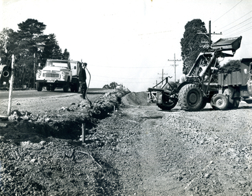
Photograph, Canterbury Road Vermont
Coloured print of a 110 slide of the making of the dual highway of Canterbury Road Vermont, near Mitcham Road.canterbury road vermont, mitcham road, vermont, roads and streets -
 Whitehorse Historical Society Inc.
Photograph, Adult Deaf & Dumb Home, Blackburn, C.1970
B/W photo of view from road of Adult Deaf & Dumb Home, Central Road, Blackburnadult deaf & dumb home, blackburn -
 Whitehorse Historical Society Inc.
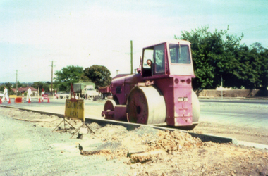
Photograph, Roadworks in Canterbury Road, Forest Hill
Black and white photo of Roadworks in Canterbury Road, Forest Hill. east of Springvale Road in conjunction with C.R.B.canterbury road, forest hill, victoria. country roads board -
 Whitehorse Historical Society Inc.
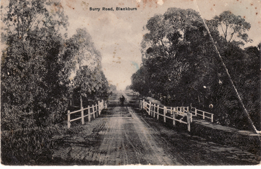
Postcard, Surry (Sic) Road, Blackburn
Black and white Postcard entitled Surry (sic) Road, Blackburn. Shows unmade road, bridge and jinker.surrey road, blackburn. -
 Whitehorse Historical Society Inc.
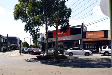
Photograph, Blackburn roundabout, 2012
Coloured photograph of the Blackburn roundabout with Blackburn Road coming in from the right to join Railway Road - 2012blackburn road, blackburn, railway road, blackburn roundabout, shops, shopping -
 Whitehorse Historical Society Inc.
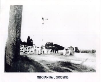
Photograph, Mitcham Railway Crossing, C 1920's
A black and white photograph of a steam train about to cross Mitcham Road. White gates across road.mitcham railway crossing, railways -
 Whitehorse Historical Society Inc.
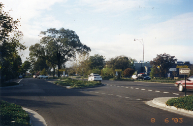
Photograph, Whitehorse Road, Mitcham
Coloured photo of Whitehorse Road looking east from the corner of Doncaster East Road. Taken 2003whitehorse road, mitcham -
 Whitehorse Historical Society Inc.
Photograph, A. C. Brown Stores, c. 1918
Used by Robin Da Costa in 'Blackburn - a picturesque history'Black & white photo of A. C. Brown Stores - south east cnr Railway Road & Blackburn Roadrailway road blackburn, blackburn road blackburn, a. c. brown stores -
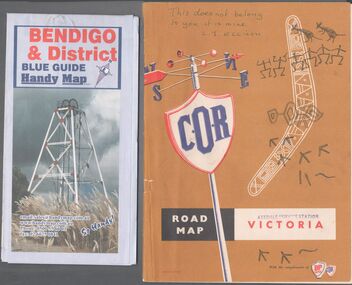 Bendigo Historical Society Inc.
Map - Road maps
BHS CollectionTwo road maps. On, Bendigo & District blue guide handy map the other a road map of Victoria. On the back of the Bendigo map the date October 2000. On the Victoria map the words in pen "This doesn't belong to you, it is mine". L.J. Ellison and a blue stamp of Axedale service station. Aileen and John Ellison Collection.road map, victoria, bendigo -
Canterbury History Group
Photograph - Lawson Bros. Grocers Pty Ltd, 1935
Interior view of a Lawson Bros grocers shop, either Highfield Road or Maling Road Canterbury c1935.canterbury, lawson bros.> grocers pty ltd, grocers, food -
Canterbury History Group
Photograph - Prospect Hill Road, Canterbury, 1920c
Black and white photograph of Prospect Hill Road Canterbury, near Maling Road, looking west, 1920ccanterbury, prospect hill road, roads and streets, houses -
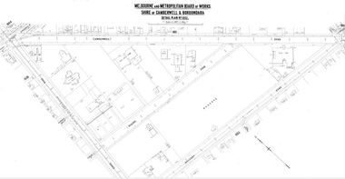 Camberwell Historical Society
Map (Item) - MMBW map, Melbourne and Metropolitan Board of Works, Melbourne and Metropolitan Board of Works - Shire of Boroondara and Camberwell - Detail Plan no. 1852, August 1904
Lithographer L.E, exd W.A.L., August 1904, no. 95. 40P. 15Wmelbourne and metropolitan board of works, map, camberwell, cartography -
Canterbury History Group
Photograph - Photograph of the bronze plaque for the Canterbury Road and Maling Road junction, Jan Pigot, 2004
Coloured photograph of the bronze plaque for the Canterbury Road and Maling Road junction. There are 2 copies of this photograph in the pocket.canterbury, maling road, shops, signs, plaques -
Canterbury History Group
Photograph - Two assistants serving behind the counter at No. 88 maling Road, Jan Pigot, 27/03/1993 12:00:00 AM
Coloured photograph of two assistants serving behind the counter of the Maling Road Patisserie at No. 88 Maling Road.canterbury, maling road, shops, foods -
Canterbury History Group
Photograph - Outside view of shop on the corner of Maling Road and Theatre Place at No. 109 Maling Road, Jan Pigot, 27/03/1993 12:00:00 AM
Coloured photograph of the outside view of shop on the corner of Maling Road and Theatre Place at No. 109 Maling Roadcanterbury, maling road, shops -
Canterbury History Group
Photograph - Street view of shop at No. 94 Maling Road, Jan Pigot, 1994
Coloured photograph of the street view of the Pharmacy on the corner of Maling Road and Bryson Street at No. 94 Maling Roadcanterbury, maling road, shops, signs -
 Halls Gap & Grampians Historical Society
Photograph - B/W, C 1940s (?)
... Roads ...Photo shows an unsealed section of Grampians Rd. near Jimmy's Creek. The sharp profile of Mt Frederick can be seen in the distance.access routes, roads -
 Halls Gap & Grampians Historical Society
Photograph - B/W, C ?
... Roads ...This is the ford over the Stoney Creek and shelter shed.The photo shows a track leading down to a large pergola type structure, surrounded by thick bush. There is a tall gum on the right of the picture, beside the track. A large branch of a tree can be seen in the top left foreground.access routes, roads