Showing 10386 items
matching plan
-
 Port Melbourne Historical & Preservation Society
Plan - Evans Street from Ingles Street to Boundary Street, Engineering Department, Town of Port Melbourne, 1893 - 1919
Plan of Evans Street from Ingles Street to Boundary Street Loan no 5 1893.engineering - roads streets lanes and footpaths -
Port Melbourne Historical & Preservation Society
Plan - Pickles Street from Sandridge Road to Spring Street/Tribe Street, Borough of Sandridge, 23 Jul 1880
Plan of Pickles Street, from Sandridge (City) Road to Spring Street/Tribe Street.engineering - roads streets lanes and footpaths -
Port Melbourne Historical & Preservation Society
Plan - Johnson Street from Graham Street to Danks Street, Borough of Port Melbourne, 25 Jul 1890
Plan of Johnson Street, from Graham Street to Danks Street. (including Drainage Sections)Michael Minahan (?) Contractor, 25-7-1890engineering - roads streets lanes and footpaths, michael minahan -
Port Melbourne Historical & Preservation Society
Plan - Concept, Boulevard upgrade at Sandridge Beach, existing conditions, 2003
Plans. Existing conditions. Concept for the Boulevard upgrade at Sandridge Beach. Dated October 2003local government - city of port melbourne, engineering - roads streets lanes and footpaths -
Port Melbourne Historical & Preservation Society
Plan - Concept, Boulevard upgrade at Sandridge Beach, traffic treatment, 2003
Plans. Traffic treatment. Concept for the Boulevard upgrade at Sandridge Beach. Dated October 2003local government - city of port melbourne, engineering - roads streets lanes and footpaths -
Port Melbourne Historical & Preservation Society
Plan - Standard Port Melbourne Council verandah, 1898
Plan for the standard council verandah designed 1890s, adopted 1899 but cancelled; then adopted 1901.Details of adoption and subsequent adoption, signed by Edwards, Crockford, Watson; written in blue pencil on back : verandahbuilt environment - commercial, henry norval edwards, william watson, arthur victor heath, edward c crockford, town clerks, david clark armstrong -
 University of Melbourne, Burnley Campus Archives
Plan, Department of Public Works, Nursery Potting Soil Bins, 1941
Plan for removal and re-erection of soil bins by Dept. of Public Works. P.P.M. Engineer.burnley school of horticulture, nursery -
University of Melbourne, Burnley Campus Archives
Plan, Aberfeldie, Trawalla, 1905
Photocopies of plans of 2 adjoining house and garden sites in Toorak, Victoria, 'Aberfeldie' and 'Trawalla'. Handwritten, "Map 937a, Map 937b 'Trawalla', Map 937c, Map 937d."aberfeldie, trawalla -
University of Melbourne, Burnley Campus Archives
Plan (Item) - Cul-de-sac planting design, 2020
cul-de-sac, planting design, john rayner -
University of Melbourne, Burnley Campus Archives
Plan, Overall Plans VACH
nursery, site plan, field station -
University of Melbourne, Burnley Campus Archives
Document, Garden Week, 1986-1991
Notes for planning Garden Week, attendance figures, site plan, etc.garden week, attendance -
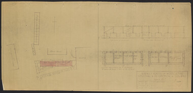
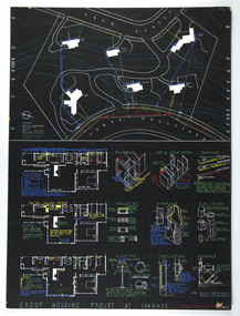 RMIT Design Archives
Architectural drawings, Plans and details for the Group Housing Project, Ivanhoe
Includes site plan; floor plans and details of utilities, interior and fittings.architecture, domestic architecture -
University of Melbourne, Burnley Campus Archives
Plan, S. Subari, Footscray Park Existing Conditions, 1987-1991
Plans by the City Engineer, City of Footscray File No 4329 drawn by S. Subari 25/9/1987. Scale 1:1000. (1) Sheet 1 of 2, 1 full plan with plant legend for trees by letter, 2 sections of plan enlarged with numbering for "Other Trees," different numbering on each. (2) Sheet 2 of 2, full plan with plant legend for trees by letter. (3) Footscray Park: Key to Tree Species. (4) 2 copies handwritten notes by John Hawker, 1 set numbered. Plant survey January 1991.footscray park, s. subari -
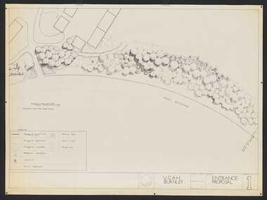 University of Melbourne, Burnley Campus Archives
Plan, Entrance Proposal, 1987-1988
Plans for Entrance from Yarra Boulevard. (1) Tracing paper and paper copies, Entrance Proposal Drawing No. 1. V.C.A.H. Burnley, Aug '87 by R.C., Planting Plan. Tracing paper and paper copies V.C.A.H. Burnley 28.9.88 by JK.vcah, burnley -
University of Melbourne, Burnley Campus Archives
Plan, Alton-Hascombe Feature Survey, c. 1990
1 tracing paper and 2 paper copies, plan by Department of Conservation, Forests and Lands. Division of Survey and Mapping. Scale 1:1000. Plan of property includes buildings, gardens and paddocks. 1 copy has significant buildings coloured.alton-hascombe, survey -
 Kew Historical Society Inc
Plan - Subdivision Plan, Summerhill Estate, 1920-1940
Pru Sanderson, in her groundbreaking ‘City of Kew Urban Conservation Study : Volume 2 - Development History’ (1988), summarised the periods of urban development and subdivisions of land in Kew. The periods that she identified included 1845-1880, 1880-1893, 1893-1921, 1921-1933, 1933-1943, and Post-War Development. These periods were selected as they represented periods of rapid growth or decline in urban development. An obvious starting point for Sanderson’s groupings involved population growth and the associated economic cycles. These cycles also highlighted urban expansion onto land that was predominantly rural, although in other cases it represented the decline and breakup of large estates. A number of the plans in the Kew Historical Society’s collection can also be found in other collections, such as those of the State Library of Victoria and the Boroondara Library Service. A number are however unique to the collection.The Kew Historical Society collection includes almost 100 subdivision plans pertaining to suburbs of the City of Melbourne. Most of these are of Kew, Kew East or Studley Park, although a smaller number are plans of Camberwell, Deepdene, Balwyn and Hawthorn. It is believed that the majority of the plans were gifted to the Society by persons connected with the real estate firm - J. R. Mathers and McMillan, 136 Cotham Road, Kew. The Plans in the collection are rarely in pristine form, being working plans on which the agent would write notes and record lots sold and the prices of these. The subdivision plans are historically significant examples of the growth of urban Melbourne from the beginning of the 20th Century up until the 1980s. A number of the plans are double-sided and often include a photograph on the reverse. A number of the latter are by noted photographers such as J.E. Barnes.The Summerhill Estate was a subdivision in Glen Iris of 24 ‘choice allotments’. The lots were primarily on both sides of Dillon Grove. Other lots at each end of the subdivision faced Margaret Street and Summerhill Road. It was from the latter that the subdivision took its advertised title. The lots were originally advertised for £10 deposit with 20 subsequent payments over five years. Pencilled on the printed plan is a change to the deposit required; a reduction to 20/-. Annotations indicate that the new deposits ranged from 30/- to 45/-. The most expensive lots faced Summerhill Road. This subdivision plan is unusual in that the front and rear of the card are for subdivisions in different localities.subdivision plans - glen iris, summerhill estate -
 Kew Historical Society Inc
Plan - Subdivision Plan, Goldthorns Hill Estate, 1925
Pru Sanderson, in her groundbreaking ‘City of Kew Urban Conservation Study : Volume 2 - Development History’ (1988), summarised the periods of urban development and subdivisions of land in Kew. The periods that she identified included 1845-1880, 1880-1893, 1893-1921, 1921-1933, 1933-1943, and Post-War Development. These periods were selected as they represented periods of rapid growth or decline in urban development. An obvious starting point for Sanderson’s groupings involved population growth and the associated economic cycles. These cycles also highlighted urban expansion onto land that was predominantly rural, although in other cases it represented the decline and breakup of large estates. A number of the plans in the Kew Historical Society’s collection can also be found in other collections, such as those of the State Library of Victoria and the Boroondara Library Service. A number are however unique to the collection.The Kew Historical Society collection includes almost 100 subdivision plans pertaining to suburbs of the City of Melbourne. Most of these are of Kew, Kew East or Studley Park, although a smaller number are plans of Camberwell, Deepdene, Balwyn and Hawthorn. It is believed that the majority of the plans were gifted to the Society by persons connected with the real estate firm - J. R. Mathers and McMillan, 136 Cotham Road, Kew. The Plans in the collection are rarely in pristine form, being working plans on which the agent would write notes and record lots sold and the prices of these. The subdivision plans are historically significant examples of the growth of urban Melbourne from the beginning of the 20th Century up until the 1980s. A number of the plans are double-sided and often include a photograph on the reverse. The Goldthorns Hill Estate subdivision was first put up for auction in 1925. The subdivision took its name from the mansion ‘Goldthorns’, shown on the plan between Normanby Road and Lady Loch’s Drive. Contemporary advertisements describe forty-three home sites being fro sale, yet only forty-one appear on this plan. Buyers were lured by the prospect of the proposed extension of the Burke Road tram to High Street. Discerning buyers were advised that only one house could be built per allotment, and that houses needed to be constructed of brick, stone or concrete and have a slate or tiled roof.goldthorns avenue -- kew east (vic.), lady loch drive -- kew east (vic.), argyle road -- kew east (vic.), lady brassey drive -- kew east (vic.), campbell street -- kew east (vic.), goldthorns -- kew (vic.), subdivisions -- kew east (viv.), goldthorns hill estate -
 Kew Historical Society Inc
Plan - Subdivision Plan, Jas R Mathers Son & McMillan, Clifton Estate, Kew, c. 1916
Pru Sanderson, in her groundbreaking ‘City of Kew Urban Conservation Study : Volume 2 - Development History’ (1988), summarised the periods of urban development and subdivisions of land in Kew. The periods that she identified included 1845-1880, 1880-1893, 1893-1921, 1921-1933, 1933-1943, and Post-War Development. These periods were selected as they represented periods of rapid growth or decline in urban development. An obvious starting point for Sanderson’s groupings involved population growth and the associated economic cycles. These cycles also highlighted urban expansion onto land that was predominantly rural, although in other cases it represented the decline and breakup of large estates. A number of the plans in the Kew Historical Society’s collection can also be found in other collections, such as those of the State Library of Victoria and the Boroondara Library Service. A number are however unique to the collection.The Kew Historical Society collection includes almost 100 subdivision plans pertaining to suburbs of the City of Melbourne. Most of these are of Kew, Kew East or Studley Park, although a smaller number are plans of Camberwell, Deepdene, Balwyn and Hawthorn. It is believed that the majority of the plans were gifted to the Society by persons connected with the real estate firm - J. R. Mathers and McMillan, 136 Cotham Road, Kew. The Plans in the collection are rarely in pristine form, being working plans on which the agent would write notes and record lots sold and the prices of these. The subdivision plans are historically significant examples of the growth of urban Melbourne from the beginning of the 20th Century up until the 1980s. A number of the plans are double-sided and often include a photograph on the reverse. A number of the latter are by noted photographers such as J.E. Barnes.The Clifton Estate was an ambitious subdivision. It included 61 allotments bordering Cotham and Park Hill Roads, and Florence and Adeney Avenues. It is difficult to ascertain the exact year when the ‘Clifton Estate’ was surveyed, subdivided and first auctioned. The uncertainty may be due to allotments being released during the First World War. The subdivision took its name from the house ‘Clifton’ (lot 5) on the corner of Adeney Avenue and Cotham Road. The outline of Clifton (since demolished) and the extent of its land following the subdivision are represented on the plan. The auctioneers have also shown ‘Maryfield’ and ‘Wimba’, the neighbouring properties in Cotham Road, on the plan."B"subdivision plans - kew, clifton estate, cotham road, adeney avenue, florence avenue, park hill road -
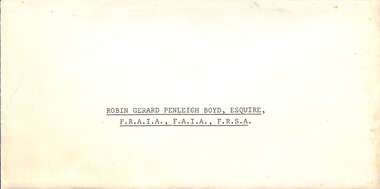 Robin Boyd Foundation
Award, Commonwealth of Australia, Honours and Awards, 1971
This is the citation appointing Robin Gerard Penleigh Boyd, Esquire F.R.A.I.A., F.A.I.A., F.R.S.A. a Commander of the Civil Division of the Most Excellent Order of the British Empire. The citation states "Member, National Capital Planning Committee. For services to Architecture and Government".Citation on Governor General Commonwealth of Australia letterhead in envelope.Honours and Awards 12 June, 1971. Appointed a Commander of the Civil Division of the Most Excellent Order of the British Empire Robin Gerard Penleigh Boyd, Esquire F.R.A.I.A., F.A.I.A., F.R.S.A. Member, National Capital Planning Committee. For services to architecture and Government. -
 Mission to Seafarers Victoria
Poster, Ying-Lan Dann, Circular Temporalities, July 2022
Take Hold of the Clouds is a curated exhibition featuring two key works by renowned international contributors – Forensic Architecture’s Cloud Studies (2021) and Cauleen Smith’s Sojourner (2018) – along with six, newly commissioned, responsive works from local and national creative practitioners. The experimental exhibition is distributed across seven of the city’s most significant buildings and urban spaces, with each temporal creative work adding a new layer to how we understand these spaces in relation to the world around us. Embedding the work within the city itself rather than a traditional gallery, the exhibition models best practices for high-impact yet sustainable and resource-sensitive exhibition-making. Created in partnership with Monash University, Take Hold of the Clouds navigates the Weekend’s theme of Built/Unbuilt through a series of thoughtful encounters in which artists reveal the invisible stories and issues in corners of the city. The exhibition is conceived by Tara McDowell, Director of Curatorial Practice at Monash Art, Design and Architecture, and co-curated with Fleur Watson, Open House Melbourne’s Executive Director. To create this poster, the artist used a copy of of one of Walter Butler plans for the 7171 building held in the archives as an homage to the architect. The sketch was then retouched to make it loo like a blueprint. The Mission is one of the sites open every year during Open House. A3 size Blue print type plan print on glose paper.open house melbourne, 2022, ying-lan dann, circular temporalities, norla dome, blueprint, plans, walter richmond butler (1864–1949), cultural events -
 Ringwood and District Historical Society
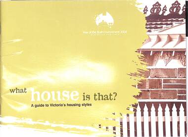
Book, What house is that?, 2007
A guide to Victoria's housing styles and eras (first and second editions)First edition - 2004, The Year of the Built Environment. Foreword by Mary Delahunty, MP, Minister for Planning. Second edition, Foreword by Hon. Justin Madden, MLC, Minister for Planning. -
Whitehorse Historical Society Inc.
Article, Two cities to go into the blender, 1994
After a year's speculation the Local Government Board has recommended in its interim report that the two municipalities be merged to form the new City of Koornung.After a year's speculation the Local Government Board has recommended in its interim report that the two municipalities be merged to form the new City of Koornung. Most of the amalgamation will be undertaken by Commissioners (to be appointed by the State Government) Nunawading City Manager, Warwick Dilley, believes to develop a corporate plan.After a year's speculation the Local Government Board has recommended in its interim report that the two municipalities be merged to form the new City of Koornung.local government, victoria. local government board, city of nunawading, city of box hill, dilley, warwick, port, ian, amalgamations -
 City of Kingston
Pamphlet - Colour, Arthur Tuckett & Son, Auctioneers and Subdivisional Specialists, Auction of Station Estate, Moorabbin, 1923
Sales plan for land in the suburb of Moorabbin, bounded by Railway Crescent, South Road, Jasper Road and Pattersons Road.The developing urban area of Moorabbin within the City of Kingston. This land sale pamphlet illustrates the subdivision of land within the municipality and the changing demographic of the district as new houses are constructed.Colour pamphlet advertising an auction of the Station Estate Moorabbin. Incorporates details of the shopping facilities, proximity to the railway line, variety of schools and churches in the area, and a sales plan for home sites and shop fronts. Incorporates a map of the estate bordered by Pattersons Road, Japer Road, South Road and Railway Crescent. Handwritten in grey pencil top right front page: Station Estate / late [indecipherable] Handwritten in red pencil on subdivision map: x [on majority of properties marked on the map] Handwritten in grey pencil on subdivision map: additional subdivisions drawn in and large lines drawn across the mapmoorabbin, land sales, estate -
University of Melbourne, Burnley Campus Archives
Plan, City Square, 1977- 1991
(1) Photocopy of plan by City of Melbourne, City Architects Office No VA47. Date not clear (January 1981?). (2) Melbourne Civic Square Stage 1, Level 2: Plan SW Sector/ Lower Square Level. Project and drawing no 7620 WT00, 20.11.1977, Revision date 10.07.1979 by Denton Corker Marshall Pty. Ltd. for Melbourne City Council. (3) Level 2: N.W. Sector. (4) Level 2: S.E. Sector. (5) Level 2: N.E. Sector. (6) Level 3 Plan: N.E. Sector Upper Square Level. (7) Level 3 Plan: S.E. Sector. (8) Melbourne City Square Diagramatic Plan: View from top of Wales Corner Building Refer 2A. (9) Melbourne Cityscope, November 5, 1990, Map 39 pp 1-2 and Map 39 June 1991. (10) Portfolio: City Square by Simon Howe, Site Inventory and Analysis, Concept Plans 1, 2, Preliminary Plan, (all Scale 1:200), Section Elevation A-A, Scale 1:100.city square, melbourne -
Bendigo Historical Society Inc.
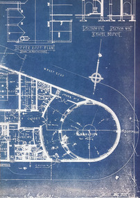
Plan - MARKS COLLECTION: PLAN OF UNDERGROUND SURVEY G. DENNIS MINE
Plan drawn on heavy parchment 'underground survey G. Dennis' printed on top of plan. Plan shows boundary lines and peg site. P. Bonati claim marked on bottom of plan. B. Letter with plan on letterhead 'City of Sandhurst, Town Hall, July 2nd. 1873' Addressed to Mr. George Dennis, Sir, In reply to your letter of the 19th. Ulto I am empowered to state that subject to the formation of the road referred to, your existing rights are conserved, and the council will undertake not to object to the renewal of your least. The only conditions being that you shall not sink a shaft in the street or attempt to obstruct it when formed. I have the honour to be, Sir, your obedient servant, Geo Fletcher, Town Clerk.bendigo, mining, g. dennis claim -
 University of Melbourne, Burnley Campus Archives
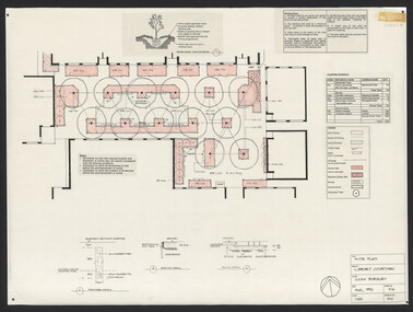
Plan, Steve Mullany, Classroom Quadrangle/Library Courtyard, 1985-1999
Various plans. (1) Photocopy of Section A-A, 1985 and 1 photocopy of part of plan. (2) Tracing paper copy, Construction Plan Classroom/Library Quadrangle Feb. 1986. (3) Master Plan, coloured and detailed and 1 copy not detailed, Classroom Quadrangle Landscape Redevelopment by S. Mullany, 10 August 1988. (4) 4 tracing paper and 2 paper copies Set of Plans Library Courtyard Aug 1992 by KW. (5) Miscellaneous sketches. (6) Assessment task. (7) Sketch Proposal Quad Entry by M. Green May 1995. (8) Quadrangle Steps Redevelopment 7/12/99 by Phil Tulk. (9) Tracing paper and paper copies Quadrangle Steps Redevelopment by JK 20.12.99.classroom, library, courtyard, steve mullany -
Bendigo Historical Society Inc.
Document - MARKS COLLECTION: STRATHFIELDSAYE PLAN 1854
Plan drawn on light paper. Written on LH side of plan 'Plan of Part of the Parish of Strathfieldsaye 1854. Scale (shown) Lithographed at the Surveyor Generals Office, Melbourne July 10th. By I. Jones'. Plan shows Emu Creek and Village Reserve at top of plan, Shepherd's Creek on RH side, Parish Boundary Line on RH and bottom of plan.map, bendigo, shire of strathfieldsaye 1854 -
 University of Melbourne, Burnley Campus Archives
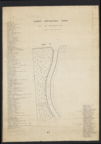
Plan, Burnley Horticultural School. Site for Experimental Plots, 1930
Pencilled notes: Planted 1930 (according to Mr. Fish). Revised 1932, 1937. Still in existence 20-9-50 A.J.T[eese] Plan with Swan St on N side and curved metal road from N to S. Details of plants on either side numbered with position marked on plan. Scale 1 inch to 20 feet. Sealed in plastic cover. Used for Centenary display. On reverse side: "Entrance & Garden Outlay"burnley horticultural school, experimental plots -
University of Melbourne, Burnley Campus Archives
Plan, Flat Concrete Roof & New Staff Room, 1981
(1) Photocopy of plan showing Flat Concrete Roof and New Staff Room. (2) Title of a plan which is probably of (1). Internal Modifications dated 4.6.81 by J.T. Crean, Ass't Director of Public Works. Donated by Sandi Pullman 2012.staff, sandra pullman -
 Melbourne Legacy
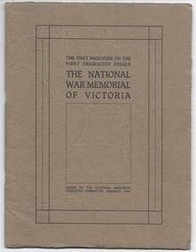
Booklet, The First Brochure on the First Premiated Design. The National War Memorial of Victoria, 1928
A booklet produced by Hudson and Wardrop, Architects, who had won the contest for the design of the Shrine. This booklet shows their models of the Shrine in photos and diagrams of the site. It goes into detail of the plans for Rock of Remembrance, the eye of light, the porticos, the tympanums, the inner Shine, and materials it will use, etc. It says: 'The theme is Remembrance, and the doing is indicative of Remembrance. It is Australian in feeling, in that is stands for the highest of Australian ideals - ideals we fought for - Patriotism, Sacrifice, Justice and Freedom.' Messrs Hudson and Wardrop were also returned servicemen. This booklet could have been used to inform the public of the plans whilst fundraising for the building project. In 1928 the Governor asked for the public to contribute approx £100,000 towards the project, while the State Government had already guaranteed £80,000. (Actual budget ended up being £250,000). Item was in an envelope with other photos and programmes from different items relating to the Shrine of Remembrance - including discussions on its location and design. Labelled 'Shrine of Remembrance S1 - S14' it was part of an old archive numbering system, that showed there has been efforts in the past to collect, order and save items of Legacy's history. (01181 - 01190, 01206 - 01211, 01649, 01650).A record of the planning for the Shrine of Remembrance with details from the architects who had won the design contest. There was an effort to record historical events for the "Archive Committee" which collected this and other documents relating to the Shrine together in a file (see items 01181 - 01190, 01206 - 01211, 01649, 01650).Booklet x 20 pages, describing plans for the Shrine, buff paper in a dark grey brown cover with black and white photos and black print.memorial, shrine of remembrance