Showing 2090 items
matching bendigo maps
-
 Bendigo Historical Society Inc.
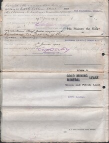
Document - MCCOLL, RANKIN AND STANISTREET COLLECTION: NAPOLEON REEF GOLD MINING CO. N.L, 1938
5 Page Legal Document with map of lease area, 6 land application forms (see attached pdf for details).organization, business, industrial - mining, mccoll rankin & stanistreet, mining, gold mining, napoleon reef -
 Bendigo Historical Society Inc.
Map - DERBY, No date visible
... Inc. History House 11 Mackenzie Street Bendigo goldfields MAP ...Map: Derby. Hand draughted parish plan (number 303 in map cupboard 1)map, bendigo, parish plan, derby -
Bendigo Historical Society Inc.
Map - EPPALOCK, COUNTY OF BENDIGO MAP, 3/11/1882
... EPPALOCK, COUNTY OF BENDIGO MAP...Map: Eppalock, County of Bendigo. Parish plan (number 302... Inc. History House 11 Mackenzie Street Bendigo goldfields MAP ...Map: Eppalock, County of Bendigo. Parish plan (number 302 in map cupboard 1)map, bendigo, parish plan, eppalock -
Bendigo Historical Society Inc.
Map - NEILBOROUGH, 15/10/1877
... Map: Neilborough, County of Bendigo. Parish plan (number... Inc. History House 11 Mackenzie Street Bendigo goldfields MAP ...Map: Neilborough, County of Bendigo. Parish plan (number 301 in map cupboard 1)map, bendigo, parish plan, neilborough, elysian flat -
Bendigo Historical Society Inc.
Map - HUNTLY, Circa 1870's
... Inc. History House 11 Mackenzie Street Bendigo goldfields MAP ...Map: Huntly, Hand draughted parish planmap, bendigo, parish plan, huntly -
Bendigo Historical Society Inc.
Map - LEICHARDT, Circa 1870's
... Inc. History House 11 Mackenzie Street Bendigo goldfields MAP ...Map: Leichardt, Hand draughted parish plan ( number 300 in map cupboard 1 )map, bendigo, parish plan, leichardt -
Bendigo Historical Society Inc.
Map - ELMORE, 3/03/1875
... Map: Elmore, County of Bendigo. Parish plan... Inc. History House 11 Mackenzie Street Bendigo goldfields MAP ...Map: Elmore, County of Bendigo. Parish planmap, bendigo, parish plan, elmore -
 Bendigo Historical Society Inc.
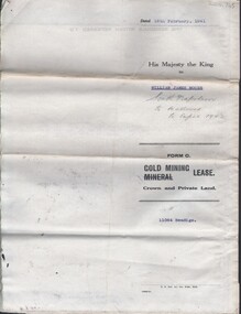
Document - MCCOLL, RANKIN AND STANISTREET COLLECTION: NAPOLEON REEF GOLD MINING CO. N.L, 18 Feb 1941
Document: 4 Page legal document with map of lease area issued to William James Moore of Bendigo, Lease No. 11064 Bendigo, Vol. 325 Fol. 35881 County of Bendigo Parish of Sandhurst, 15 year lease from 18th February 1941, in vacinity of Curnow St, Booth St, Maple St and Rowan Sts, Lease by South Napoleon to be allowed to lapse in 1942, signed by Major General Sir Winston Joseph Dugan Governor of Victoria, William James Moore & witnessed by Walsh, Wardens Clerk Bendigo.organization, business, industrial - mining, mccoll rankin & stanistreet, mining, gold mining, napoleon reef -
Bendigo Historical Society Inc.
Map - JANIEMBER EAST, No date visible
... Inc. History House 11 Mackenzie Street Bendigo goldfields MAP ...Map: Janiember East, Hand Draughted? Parish plan (number 299 in map cupboard 1)map, bendigo, parish plan, janiember east , serpentine -
Bendigo Historical Society Inc.
Map - COUNTRY LANDS, 4/06/1874
... Inc. History House 11 Mackenzie Street Bendigo goldfields MAP ...Map: Country lands, Parishes of Goornong, Egerton, Elmore and Nolan, County of Bendigo. Parish plan (number 298 in map cupboard 1)map, bendigo, country lands, country lands, goornong, elmore, egerton, nolan -
Bendigo Historical Society Inc.
Map - LOCKWOOD, 13/03/1876
... Map: Lockwood, County of bendigo. Parish plan... Inc. History House 11 Mackenzie Street Bendigo goldfields MAP ...Map: Lockwood, County of bendigo. Parish planmap, bendigo, parish plan, lockwood -
 Bendigo Historical Society Inc.
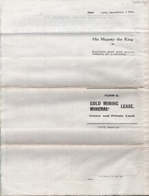
Document - MCCOLL, RANKIN AND STANISTREET COLLECTION: NAPOLEON REEF GOLD MINING CO. N.L, 22 August 1950
Document: 5 Page legal document with map of lease area, Lease No. 11273 Bendigo, Vol.331, Fol. 36453, 15 year lease from 12 December 1949, in vicinity of Inglis, Harvey & Curnow Streets, Signed by Dallas Brooks, Gov of Victoria & J.J. Stanistreet, Mine Manager.organization, business, industrial - mining, mccoll rankin & stanistreet, mining, gold mining, napoleon reef -
Bendigo Historical Society Inc.
Map - AXEDALE, 26/07/1877
... Map: Axedale, Counties of Bendigo and Rodney. Parish plan... Inc. History House 11 Mackenzie Street Bendigo goldfields MAP ...Map: Axedale, Counties of Bendigo and Rodney. Parish planmap, bendigo, parish plan, axedale -
Bendigo Historical Society Inc.
Map - REDCASTLE, 15/10/1878
... Inc. History House 11 Mackenzie Street Bendigo goldfields MAP ...Map: Redcastle, County of Rodney. Parish planmap, rodney, parish plan, redcastle -
Bendigo Historical Society Inc.
Map - METCALFE, 30/10/1878
... Inc. History House 11 Mackenzie Street Bendigo goldfields MAP ...Map: Metcalfe, County of Dalhousie. Parish plan (also has a smaller addition glued onto the right hand side)map, dalhousie, parish plan, metcalfe -
Bendigo Historical Society Inc.
Map - AXEDALE, 10/10/1904
... Map: Axedale, Counties of Bendigo and Rodney. Parish plan... Inc. History House 11 Mackenzie Street Bendigo goldfields MAP ...Map: Axedale, Counties of Bendigo and Rodney. Parish plan (number 297 in map cupboard 1)map, bendigo, parish plan, axedale -
Bendigo Historical Society Inc.
Map - MANDURANG 2, March 194-?
... Inc. History House 11 Mackenzie Street Bendigo goldfields MAP ...Map: Mandurang 2, County of Bendigo. Parish plan (number 296 in map cupboard 1)map, bendigo, parish plan, mandurang -
Bendigo Historical Society Inc.
Map - MANDURANG, 10/11/1909
... Map: Mandurang, County of Bendigo. Parish plan... Inc. History House 11 Mackenzie Street Bendigo goldfields MAP ...Map: Mandurang, County of Bendigo. Parish planmap, bendigo, parish plan, mandurang -
Bendigo Historical Society Inc.
Map - MANDURANG, Date unreadable
... Map: Mandurang, County of Bendigo. Parish plan... Inc. History House 11 Mackenzie Street Bendigo goldfields MAP ...Map: Mandurang, County of Bendigo. Parish planmap, bendigo, parish plan, mandurang -
Bendigo Historical Society Inc.
Map - MANDURANG 2, Examined 11/12/1879
... Inc. History House 11 Mackenzie Street Bendigo goldfields MAP ...Map: Mandurang 2, County of Bendigo. Parish planmap, bendigo, parish plan, mandurang -
Bendigo Historical Society Inc.
Map - MANDURANG 1, March 1947
... Inc. History House 11 Mackenzie Street Bendigo goldfields MAP ...Map: Mandurang 1, County of Bendigo. Parish plan (number 295 in map cupboard 1)map, bendigo, parish plan, mandurang -
Bendigo Historical Society Inc.
Map - JANIEMBER EAST, 26/07/1879
... Inc. History House 11 Mackenzie Street Bendigo goldfields MAP ...Map: Janiember East, County of Bendigo. Parish planmap, bendigo, parish plan, janiember east, serpentine -
Bendigo Historical Society Inc.
Map - HAYANMI, 16/05/1879
... Map: Hayanmi, County of Bendigo. Parish plan (number 294... Inc. History House 11 Mackenzie Street Bendigo goldfields MAP ...Map: Hayanmi, County of Bendigo. Parish plan (number 294 in map cupboard 1)map, bendigo, parish plan, hayanmi -
Bendigo Historical Society Inc.
Map - HUNTLY, 16/11/1903
... Map: Huntly, County of Bendigo. Parish plan... Inc. History House 11 Mackenzie Street Bendigo goldfields MAP ...Map: Huntly, County of Bendigo. Parish planmap, bendigo, parish plan, m -
Bendigo Historical Society Inc.
Map - REDCASTLE AND DARGILE, No date visible
... Inc. History House 11 Mackenzie Street Bendigo goldfields MAP ...Map: Redcastle and Dargile. Parish planmap, parish plan, redcastle, dargile -
Bendigo Historical Society Inc.
Map - REDCASTLE, 15/10/1878
... Inc. History House 11 Mackenzie Street Bendigo goldfields MAP ...Map: Redcastle, County of Rodney. Parish plan. (number 293 in map cupboard 1)map, rodney, parish plan, redcastle -
Bendigo Historical Society Inc.
Map - WESTON RESURVEY, June 20th 1875
... Inc. History House 11 Mackenzie Street Bendigo goldfields MAP ...Map: Weston, Resurvey.Hand draughted Parish plan (number 292 in map cupboard 1)map, parish plan, weston -
Bendigo Historical Society Inc.
Map - STRATHFIELDSAYE, 25/06/1877
... Map: Strathfieldsaye, County of Bendigo. Parish plan... Inc. History House 11 Mackenzie Street Bendigo goldfields MAP ...Map: Strathfieldsaye, County of Bendigo. Parish plan (number 291 in map cupboard 1)map, bendigo, parish plan, strathfieldsaye -
Bendigo Historical Society Inc.
Map - PARISHES OF WARRAGAMBA AND MINTO, No date visible
... Inc. History House 11 Mackenzie Street Bendigo goldfields MAP ...Map: Parishes of Warragamba and Minto,Hand draughted parish plan. (number 290 in map cupboard 1)map, parish plan, warragamba, minto -
Bendigo Historical Society Inc.
Map - HUNTLY ALLOTMENTS, No date visible
... Inc. History House 11 Mackenzie Street Bendigo goldfields MAP ...Map; Huntly Allotments, County of Bendigo. Parish plan (number 289 in map cupboard 1)map, bendigo, allotments, huntly allotments